Adolphe JoanneLivre Rare Book

199 résultats
1899réf. CZC-13391Itinéraire général de la France, illustré de 6 cartes et 24 plans. Renseignements pratiques mis au courant en 1903. vol. 18x13, bon état intérieur, couverture bleue avec usures, 343pp + 106pp, catalogue Joanne. Paris, Hachette, 1899 ref/117
1899réf. CZC-13391Itinéraire général de la France, illustré de 6 cartes et 24 plans. Renseignements pratiques mis au courant en 1903. vol. 18x13, bon état intérieur, couverture bleue avec usures, 343pp + 106pp, catalogue Joanne. Paris, Hachette, 1899 ref/117
réf. ria9782014022575_inpPaperback. New. New Book; Fast Shipping from UK; Not signed; Not First Edition; Dictionnaire géographique et administratif de la France et de ses colonies. 7 Se-Z / publié sous la direction de Paul JoanneDate de l'édition originale : 1890-1905Le présent ouvrage s'inscrit dans une politique de conservation patrimon paperback
réf. 139103791X.Gpaperback. Good. Access codes and supplements are not guaranteed with used items. May be an ex-library book. paperback
réf. 0483245887.Ghardcover. Good. Access codes and supplements are not guaranteed with used items. May be an ex-library book. hardcover
réf. 1390032175.Ghardcover. Good. Access codes and supplements are not guaranteed with used items. May be an ex-library book. hardcover
réf. 1396480161.Ghardcover. Good. Access codes and supplements are not guaranteed with used items. May be an ex-library book. hardcover
réf. 0366058657.Ghardcover. Good. Access codes and supplements are not guaranteed with used items. May be an ex-library book. hardcover
1875réf. 481434L. Hachette Paris 1875. First Edition. Softcover. Good copy in the original stiff-card wrappers; edges slightly nicked and dust-dulled as with age. Slight suggestions of foxing overall. Remains particularly well-preserved overall. Date suggested. Physical description; VIII-464 p. figure carte et plans ; In-16. Subjects; 19th-Century Tourism. Railway Tourism. Topography & Local History. Urban Travel & City. Directories. Publishing History. L. Hachette, Paris paperback
réf. 1391776747.Ghardcover. Good. Access codes and supplements are not guaranteed with used items. May be an ex-library book. hardcover
réf. 0483096989.Ghardcover. Good. Access codes and supplements are not guaranteed with used items. May be an ex-library book. hardcover
réf. ria9783752538540_inpPaperback. New. New Book; Fast Shipping from UK; Not signed; Not First Edition; Unveränderter Nachdruck der Originalausgabe von 1867. paperback
réf. 420497Hachette. Hardcover. Fair. Blue cloth with gilt titles to front and spine rubbed and bumped corners. Scuffed back board and spine. First few pages of prelims missing. Front and back boards partly detached though the remaining pages are firmly attached to the binding. French text. Contains numerous pull out maps all of which are intact and in good condition. Original publisher's advertisement section at the back of the book. Hachette hardcover
réf. 0332703517.Ghardcover. Good. Access codes and supplements are not guaranteed with used items. May be an ex-library book. hardcover
réf. 0366549278.Ghardcover. Good. Access codes and supplements are not guaranteed with used items. May be an ex-library book. hardcover
réf. 1391308247.Ghardcover. Good. Access codes and supplements are not guaranteed with used items. May be an ex-library book. hardcover
réf. ria9783752538557_inpHardcover. New. New Book; Fast Shipping from UK; Not signed; Not First Edition; Unveränderter Nachdruck der Originalausgabe von 1867. hardcover
réf. ria9783382203566_inpPaperback. New. New Book; Fast Shipping from UK; Not signed; Not First Edition; Réimpression inchangée de l'édition originale de 1868. La maison d'édition Anatiposi publie des livres historiques en réimpression. En raison de leur âge ces livres peuvent présenter des pages manquantes ou une qualité moindre. Notre o paperback
réf. 351991 page in8 - trés bon état - En tête: "Guides et Itinéraires sous la direction de M. Adolphe Joanne" - "Librairie Hachette" -
réf. 7399"Contenant 108 gravures et 6 cartes" Paris chez Hachette et Cie 1873 Grand in-8 (192 x 272mm) dos chagrin vert à 4 nerfs, caissons ornés or, plats percaline verte, ornée à froid, gardes moirées,toutes tranches dorées, 2ff., IV, 431 pages, bien complet de ses cartes et gravures ... Très bel exemplaire, au papier très blanc, rare sans rousseurs , et angles parfaits ....
réf. 016934Paris: Librarie de L. Hachette . Hardcover. Good. Hardcover book in good condition. Includes fragile extraordinary map of Paris in back pocket. No date on book map dated 1859. Covers show some shelf wear rubbing at spine's top and bottoms. Some writing in pen and pencil on end pages title page. Light foxing throughout. Text complete. Questions welcome. We ship internationally from the United States and Canada every week. If buying internationally please be aware that additional charges may apply for heavier books. We guarantee a safe quick and secure transaction. 10 years in online bookselling experience. Librarie de L. Hachette hardcover
1867réf. 73669Hachette | Paris 1867 | 11 x 17.80 cm | relié
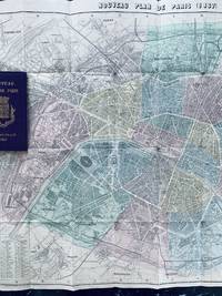
1867réf. 73669Paris: Hachette 1867. Fine. Hachette Paris 1867 11 x 17.80 cm relié Collection des guides Joanne series. Alphabetical list of Paris streets with also the list of omnibuses and their routes fares mobile carriages and other public transport. Publisher's binding in full purple cloth. Smooth unlettered spine. Title and arms of Paris on the first cover. Large folding map of Paris in colors. Several small tears. Handsome copy. The Paris of Napoleon III and Haussmann. This map of Paris was published for the 1867 Paris Universal Exhibition. At the end of the chapter on public carriages one reads: ""A special service from Place du Palais-Royal to Pont d'Iéna will operate throughout the duration of the exhibition"". Hachette hardcover
1873réf. RO30008448Hachette. 1873. In-Folio. Relié. Bon état, Couv. convenable, Dos satisfaisant, Intérieur frais. 95 planches de cartes topographiques en couleurs augmentées d'une description/explication de la carte (double page explication-carte en regard); une carte découpée; une carte dépliante abîmée; cartonnage éditeur, titre doré sur plat et dos, motifs dorés sur dos, roulettes; dessiné par Alp. Mouraux, gravé chez Erhard.. . . . Classification Dewey : 912-Atlas, cartes et plans