631 resultados
1967ref. 44603Copenhagen 1967-69. 4to. Orig. hcloth. 12918453 pp. tables and more that 200 plates. some folding. Clean and fine. hardcover
ref. DADAX0817308245New unknown
ref. SONG1908145161Used: Good unknown
ref. DADAX0230363261New unknown
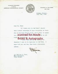
1920ref. 501237"V. Stefansson" in black fountain pen ink on pictorial American Geographical Society letterhead Ottawa Ontario Canada July 9 1920. 8 1/2" x 11"; 1 page; very good. Together with the original typed envelope stamped and postmarked Ottawa Ont. July 9 1920 with two stamps. To Dr. William C. Thro East Northport Long Island New York "Dear Dr. Thro: If I were only in New York I should take instant advantage of your invitation to visit you on the Long Island coast but I shall be spending most of my summer in Canada with only an odd visit to the city. I shall look you up in the fall or whenever I come to be regularly in New York. I hope both you and Mrs. Thro have a delightful summer. V. Stefansson." Stefansson 1879-1962 American ethnologist/explorer/author; lived amongst the Eskimo 1906-07; Canadian/Alaskan Arctic expedition commander 1913-18; consultant to Dartmouth College's Northern Studies program 1947-62. unknown
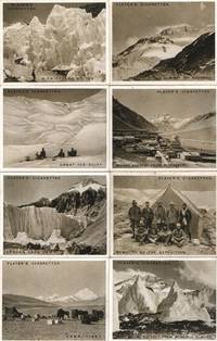
ref. 53426with wonderful views from the route taken through the plains of Tibet up the Rongbuk Glacier the North Col with its ice wall and the North-East Ridge beginning with nine members of the expedition including Irvine and Mallory who lost their lives card 1 Everest from the glacier the monastery at 16000 feet and that at Shekar-Dzong on a rock pinnacle astonishing pictures of the ice formations Nepalese porters climbing the ice wall at 22000 feet and a view taken from 'The Top of the World' at 28000 feet by Dr Somervell looking down on the peaks and clouds card 18 the other photographs are by Captain Noel the descriptions are most evocative and informative about the weather the rarefied air the temperatures and the local living conditions together 14 cards 3" x 2½" John Player & Sons no date circa lacking cards 36131619 and 20 unknown
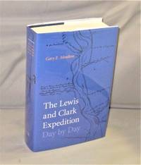
2018ref. 28379Lincoln:: University of Nebraska Press 2018. First Printing of the First US Edition. A Fine unread copy in a Fine dust jacket. In May 1804 Meriwether Lewis William Clark and their Corps of Discovery set out on a journey of a lifetime to explore and interpret the American West. The Lewis and Clark Expedition Day by Day follows this exploration with a daily narrative of their journey from its starting point in Illinois in 1804 to its successful return to St. Louis in September 1806. This accessible chronicle presented by Lewis and Clark historian Gary E. Moulton depicts each riveting day of the Corps of Discovery’s journey. Drawn from the journals of the two captains and four enlisted men this volume recounts personal stories scientific pursuits and geographic challenges along with vivid descriptions of encounters with Native peoples and unknown lands and discoveries of new species of flora and fauna. University of Nebraska Press, unknown
2003ref. 004175Potts Point NSW Australia: Hordern House 2003. Hardcover. As New/as new. 4to. xv 1168 pp. Bound in full olive cloth title in gilt on cover and spine three ribbon bookmarks in illustrated dust jacket. Includes bibliography and index. This is the first volume in a five-volume work. As New in As New dust jacket. Hordern House hardcover
ref. thl89London: Trübner & Co. 1886. First Edition. Meteorological and magnetic observations made at Fort Rae a Hudson’s Bay Company post on the north shore of Great Slave Lake from Sept. 1 1882 to August 31 1883. Fort Rae formed one of a series of circumpolar positions occupied in accordance with the scheme proposed by Lieut. Weyprecht for concerted physical observations to be carried on for at least a full year at different stations situated around the Poles. The four-man expedition under the command of Captain Henry P.Dawson was organized by the Royal Society of London and financed by the Government of Canada and Great Britain. Arctic Bib. 7748. folio. pp. xiv 326. 32 folding charts. 3 plans in text. A very good copy in original blind-stamped cloth title & verso of last chart browned. thl89 London: Trübner & Co., 1886 hardcover
1844ref. E0023xcii616 pages with bibliography. Octavo 8 1/2" x 5 1/2" bound in contemporary half calf with black spine label and gilt lettering. Publications de la Societe d'Etudes pour la colonisation de la Guyane francaise Number 4. The bibliographical catalogue occupies pages 579-616 and contains descriptions of 240 works on Guiana. Sabin 56097. First edition. French Guiana French: Guyane française officially Guyane is an overseas department French: département d'outre-mer or DOM of France located on the northern coast of South America. It has borders with two nations Brazil and Suriname. Like the other DOMs French Guiana is also an overseas region of France one of the 26 regions of France. Its currency is the euro. The prefecture is Cayenne. The addition of the adjective "French" comes from colonial times when three such colonies existed: British Guiana now Guyana Dutch Guiana now Suriname and French Guiana. The three are still often collectively referred to as the Guianas. French Guiana was originally inhabited by a number of indigenous American people. It was settled by the French during the 17th century. After the Treaty of Paris in 1763 Louis XV sent 12000 settlers to French Guiana to colonise the region. One and a half years later only a few hundred survived.2 Its infamous Île du Diable Devil's Island was the site of penal settlements from 1852 until 1951. More than 70000 French convicts were deported to French Guiana between 1852 and 1939.3 In 1809 a Portuguese-British naval squadron took French Guiana for the Portuguese Empire. With the signing of the Treaty of Paris in 1814 the region was handed back to the French though a Portuguese presence remained until 1817. A border dispute with Brazil arose in the late nineteenth century over a vast area of jungle leading to the short-lived pro-French independent state of Counani in the disputed territory and some fighting between settlers before the dispute was resolved largely in favor of Brazil by the arbitration of the Swiss government. Condition: Front inner hinge cracked rubbing to hinges and corners some internal foxing else a very good copy. Imprimerie de Bethune and Plon hardcover
ref. 115717London Harrison & Sons 1921. . First edition; 4to; four photographic plates to the rear; publisher's original paper wrapper; a fine copy; iii 106pp. A report on the pendulum observations made by Charles Seymour Wright during Captain Scott's 'Terra Nova' expedition. Rosove 293-6. A1. London, Harrison & Sons, 1921. unknown
ref. 115719London Harrison & Sons 1924. . First edition; 4to; five figures in text folding plan in rear pocket; publisher's original paper wrapper; a fine copy; 75pp. A collection of scientific and logistical data compiled during the 'Terra Nova' expedition by Colonel H.G. Lyons notably containing a detailed description and fold-out plan of the 'Terra Nova' steamship itself. Rosove 293-13. A1. London, Harrison & Sons, 1924. unknown
ref. 115716London Harrison & Sons 1921. . First edition; 4to; four figures in text; publisher's original paper wrapper; a fine copy; viii 46pp. An official report into the auroral observations made at Cape Evans and Cape Adare during Captain Scott's 'Terra Nova' expedition. Rosove 293-5. A1. London, Harrison & Sons, 1921. unknown
ref. 115722London Harrison & Sons 1923. . First edition; 4to; 15 plates one folding diagram 12 figures in text five folding maps in rear pocket light water stain to inner margin; publisher's original paper wrapper; a very good copy; xiii 40pp. A detailed scientific report from the 'Terra Nova' expedition with maps photographs and diagrams of the Ross Archipelago. Authored by Frank Debenham later founder and first director of the Scott Polar Research Institute. Rosove 293-9. A1. London, Harrison & Sons, 1923. unknown
ref. 115723London British Museum 1921. . First edition; 4to; eight figures in text one plate leaf; publisher's original paper wrapper; a fine copy; pp. 101-130. Geological report from the 'Terra Nova' expedition detailing the sedimentary rock formations of South Victoria Land with maps diagrams and photographs. Rosove 292-5. London, British Museum, 1921. unknown
ref. BN610349Karluk. Die Geschichte einer verratenen Expedition McKinlay William L and Seib Günter Karluk. Die Geschichte einer verratenen Expedition McKinlay William L and Seib Günter Karluk. Die Geschichte einer verratenen Expedition McKinlay William L and Seib Günter unknown
1904ref. 34773Edinburgh: T. & T. Clark 1904. First Edition. profusely illustrated with 33 black and white illustrations on glossy plates including a map and city plan and with a fold out map of the Mounds of Nippur. 8vo publisher's original buff decorated cloth the upper cover with a portrait of a Hillah workman in buff red black and white within a black border with black lettering the spine gilt lettered and ruled in black with small Sumerian bird symbol in red top edge gilt. xii 355 pp. A fine copy the text-block perfectly clean and fresh slight mellowing to prelims and fore-edge only the binding very sound and fresh with just a tiny bit of age evidence a beautiful copy. FIRST EDITION AND A POPULAR ACCOUNT OF THE IMPORTANT BABYLONIAN EXPEDITION OF THE UNIVERSITY OF PENNSYLVANIA. The author was the only English member of the American expedition giving him a unique perspective on its intentions and discoveries. BY NILE AND EUPHRATES is not a typical expedition log; it is an account of life in an excavator's camp the journey to camp and the people encountered along the way. As British member of Petrie's archeological expedition to Egypt and Mesopotamia Geere was present during the important excavations at Nippur. Nippur was situated on both sides of the ancient bed of the Shatt-en-Nil canal one of the earliest courses of the Euphrates between the present bed of that river and the Tigris almost 160 km southeast of Baghdad. The canal bed divides the site into an East Mound and West Mound. It is represented by the great complex of ruin mounds known to the Arabs as Nuffar written by the earlier explorers Niffer and later as Nippur. Nippur was first excavated briefly by Sir Austen Henry Layard in 1851. But full-scale digging was begun by the expedition from the University of Pennsylvania. The work involved four seasons of excavation between 1889 and 1900 and was led by John Punnett Peters John Henry Haynes and Hermann Volrath Hilprecht all of whom were known to and cited by Geere. Thousands of tablets were found at a smaller mound dubbed "tablet hill" about 7.5 meters in average height and 52 square meters in area southeast of the temple mound.A true arch one of the world's earliest examples was also found. In the Parthian layer a box containing fragments of votive axes made of glass from the Kassite period were found. Several late Kassite rulers are represented including Kurigalzu II. T. & T. Clark hardcover
1854ref. 1102250022Philadelphia: Blanchard and Lea 1854. Ninth Edition Revised. Leather Bound. Very Good. Published in 1854. Large 8vo. 509 pp. Collated. Complete. Two maps and multiple illustrations all in very good condition. Clean unmarked pages no foxing. Bound in contemporary leather somewhat worn. Covers in good shape with only slight bumping gold gilt spine lettering and imprint on front cover. Back cover looks like it was imprinted as well but the gilt is missing. Binding is in excellent shape. Ships daily. Captain William Francis Lynch commander of the 1847 USN expedition to the Dead Sea wrote this chronicle of the journey upon his return to the United States. A native Virginian he later served in the Confederate Navy but he was repatriated to the United States after the American Civil War. Blanchard and Lea hardcover
ref. 004286nd. 1931. original unused pictorial postcard featuring a monochrome photo from the German 1929 or 1931 Himalayan Expeditions to Kangchenjunga both led by Paul Bauer showing a view of the mountain from the Zemu Valley. A very fine copy. For an account of this expedition see Bauer's 1937 'Himalayan Campaign. The German Attack on Kangchenjunga'. Oxford: Basil Blackwell. unknown
1960ref. 0039081960 Original pictorial postcard with four Nepali Stamps. Signed by 8 team members Max Eiselin Kurt Diemberger Albin Schelbert Ernst Forrer Peter Diener Hugo Weber Michel Vaucher and Jerzy Hajdukiewicz and two sherpas. A very good copy. The first ascent of Dhaulagiri then the highest unclimbed peak by a Swiss team lead by Max Eiselin in 1960. See Max Eiselin 'The Ascent of Dhaulagiri' and Kurt Diemberger's 'Summits and Secrets' both of which can be purchased from us. Signed by the Team Members. unknown
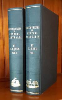
1997ref. 23887Adelaide: Friends of the State Library of South Australia. Fine. 1997. First thus. Hardcover. 1876154101 . Sent by the colonists of South Australia with the sanction and support of the government; including an account of the manners and customs of the aborigines and the state of their relations with Europeans. In two volumes. Edition limited to 600 copies of which the first 99 are numbered and bound in quarter leather this being an unnumbered set bound in cloth. An as new set. ; Australiana Facsimile Editions No. 213; 225 x 145mm . Friends of the State Library of South Australia hardcover
1930ref. 145029London: British Museum 1930. vi6161 pp. Octavo. Original wine coloured gilt cloth. Gilt title on spine. 3 plates including frontispiece and illustrations in text from sketch maps plans etc. A very nice copy Rosove 313.A1 Taurus 113 Shackleton died on the "Quest" expedition after having reached South Georgia. Even with the tragedy the Expedition pushed on and the present work gathers thirteen papers concerning the the expedition geological work. Nice non x-lib copies are much harder to find. 1930 British Museum hardcover
1855ref. rbr1-mar64Scattered light foxing. 556 pages incl. index; 3 fold-out maps 1 large panorama - chromolithiograph; 10 illustrations one of which is in color. Vol. I only 4 raised bands. gilt lettring on black leather label on spine is VG. 1" portion of Leather missing at top of spine. Leather corners worn and generally edge worn boards. Water staining to side edges of front free endpapers and frontis and title page along with additional water marks of 2 additional fold out maps prior to the beginning of the numbered pages. Not affecting the images of these fold outs. No foxing or internal markings. Front hinge jsut starting to crack. Still a quite good copy in better than average condition. Photos on request. Additional shipping charges will apply based on destination and speed. U. S. Government Printing Office, A. O. P. Nicholson, printer hardcover
1880ref. 1309New York: Henry Holt and Company. Very Good. Hardcover. Some fraying to top and bottom spine. Front hinge weakening. Some fraying to rear map margin not effecting printed area. Previous owner's name to front pastedown; Rare. Numerous b&w illustrations and two maps; 8vo; 448 pages . 1880. Henry Holt and Company hardcover
1970ref. 004083Munich: The Expedition 1970 Original pictorial postcard with Pakistan Stamps 50 paisa postmarked Gilgit 9 May 1970 with expedition cachet; Signed by 16 team members including leader Karl Herrligkoffer summiteers Reinhold Messner Felix Kuen and Peter Scholz as well as Michl Anderl Gerhard Baur Wolf-Dietrich Bitterling Werner Haim Gunther Kroh Hermann Kuhn Gerd Mandl Elmer Raab Hans Saler Peter Vogler Jurgen Winkler Alice Von Hobe Max von Kienlin and a sherpa thumbprint. A near fine copy. The success of the German 1970 Rupal Face expedition to Nanga Parbat was marred by the death of Gunther Messner after descending the unknown slopes of the Diamir Face. Signed by the Expedition Team. First Edition. Soft Cover. F-. The Expedition paperback