16 résultats
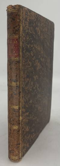
1833réf. 49821New York: G & C & H Carvill 1833. First Edition. Octavo. Original pebble-grained boards; paper spine title; 1-78-1582pp. Backstrip partially detached ; spine label faded barely legible; text fresh and unmarked - Good or better. Ex-U.S. Naval Lyceum with ink pressure stamp to endpapers and title page with de-accession dated 1927 on verso of title page. Pencil ownership inscription of a "Thos. J. Manning U.S. Navy" at head of title page. Verso of final text leaf prints a brief list of errata. G & C & H Carvill unknown books
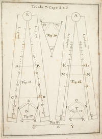
1753réf. 3742NAPLES: IGNAZIO RUSSO 1753. FIRST EDITION. Hardcover. Fine. Bound in contemporary vellum over boards. Foxing. Complete with the 15 engraved plates. Little is known of the author other than that he wrote another book on navigation in 1750. This work on the sector was translated into Spanish in 1758. By the time this book was published the design of the European sector had become standardized. Compare this design for example with that in the fourth edition of the works of Ozanam seventeen years earlier L’usage du compas de proportion 1736. The physical design of Pagnini’s instrument is better with pegs and decorative tenons to hold the two legs in alignment but the scales are essentially identical. The work is well illustrated with engravings showing exactly how a pair of dividers should be used to take the various lateral and transverse measurements. Pagnini provides eight tables that detail the exact markings for each scale. He also provides other material for reference use e.g. he includes not only a table for the construction of the line of metals but also one of their relative weights and their alchemical symbols etc. IGNAZIO RUSSO hardcover books
1939réf. RiverPilotHUDSON RIVER NAVIGATION Godfrey's river and canal pilot: useful information for masters pilots mates and yachtmen navigating the Hudson River New York State Barge Canals and Long Island Sound. Compiled by Daisy M and Frank H Godfrey. Rome NY: Republican Printing Company 1939. 8vo 33pp; blue textured paper covers lettered in silver a fine copy overall. First and apparently only printing OCLC locating only two copies. Extensive listing of magnetic compass courseCayuga Ls including the Hudson River both North and South bound Oneida Lake Cayuga Lake Seneca Lake Erie Canal Oswego Canal Buffalo Harbor Long Island Sound and New Haven maint entrance to Stratford Point. Republican Printing Company paperback books
1896réf. 6694Washington. Government Printing Office. 1896. Bound in gilt titled royal blue cloth. Square 8vo. First Edition. Mild scuffing to covers corners gently rubbed mild foxing to prelims. A Very Good copy. Government Printing Office. hardcover books
1899réf. 70852Richmond VA: Virginia Navigation Co 1899. First edition. Broadside lithograph Hoen & Co. Richmond 12 ¼ x 16 ½ inches in four colors "showing steamer route and landings; also shows battlefields light-houses canals and stage lines . includes promotional text verso for the company and route up the river from Norfolk to Richmond" OCLC. "James River day route between Richmond Old Point Comfort Portsmouth Norfolk Newport News Jamestown and James River Landings." OCLC locates four copies New York Public Alabama Virginia Wisconsin Historical Society. Folded to narrow 8vo. a little browning verso tear into one fold still very good. Virginia Navigation Co unknown books
1847réf. 1008098vo slate blue cloth stamped in gilt and blind illustrated with frontispiece and folding charts viii 21 429 3 24 pp.Wear to spine ends spine faded small splits to joints hinges cracked copious nautical notes to endpapers slight aging but text and charts are generally clean and unworn; about very good. This is rare first edition of what is known as "The Atlantic Navigator" which includes detailed sailing instructions for the North and South Atlantic. Includes ten folding charts and much of the text is from various captains and navigators familiar the routes contained in this work. The first numbered section of 21 pages is an 1847 supplement and the catalogue at the rear is dated 1851. Sabin noting 2300 only an 1854 fourth edition. James Imray, books
1858réf. 54442n.p. n.d. 1858. 8vo pp. 20; self-wrappers; fine. UC-Riverside and AAS only in OCLC. In 1855 while charting the Rio de Plata Basin the United States ship U.S.S. Water Witch was fired upon by a Paraguayan fort killing the helmsman Samuel Chaney. This outraged the U.S. government who along with the U.S. & Paraguay Navigation Company decided to bring the incident to the Supreme Court. In 1858 began the Paraguay Expedition the purpose of which was to demand an apology from the Paraguyan government and to address alleged insults against the Navigation Company. The result of the expedition was that Paraguay apologized the Chaney's family was indemnified and a new advantageous commercial treaty between Paraguay and the United States was forged. unknown books
1996réf. 22915Erin: Boston Mills Press Stoddart. Fine in Near Fine dust jacket. 1996. Hardcover. 1550461656 . Black and white photographs throughout. First edition. Fine in a very near fine spot of edge wear at the top of the front panel dust jacket. . Boston Mills Press (Stoddart) hardcover books
1829réf. 57255Washington: NP. Very Good. 1829. Paperback. Pamphlet disbound 20pp. some foxing good. 20th Congress 2d Session Rep. No. 62. Ho. of Reps. . NP paperback books
1839réf. 331758London: Smith Elder and Co 1839. Softcover. Good. First edition. Octavo. Disbound. 49pp. folding map. Lacking wrappers; title page and folding map detached from sewing; good. A scarce report establishes an early point for the English empire's interest in establishing a steam boat line in India and the methods by which they proposed to go about doing so. Commercial manufacturers and various merchants from Manchester Liverpool and India were enlisted to support the proposal and the report outlines navigational routes estimations of cost and the enthusiasm of changing maritime trading methods up and down the Ganges. The idea for an East India Inland Steam Navigation Company apparently began percolating in 1837 and this report fits nicely within the small pantheon of material devoted to this literature. Not in OCLC. One copy found at the British Library. Smith, Elder and Co unknown books
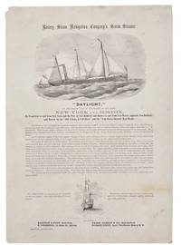
1860réf. 42341New York 1860. Broadside 11-1/4" x 16." Two vignettes of ships engraved by Waters & Son. Light dusting upper left blank corner with a small chip. Very Good. The broadside touts describes and praises this "first-class steamer of 432 tons register." The Daylight's officers are listed its construction history described and its dimensions disclosed. The Daylight "is fitted up in a style unsurpassed by any of the Sound Propellers. The Ladies' Cabin contains seven state-rooms each having three berths and Gentlemen's Cabin has twenty-four berths. She has every modern convenience and every requisite for a sea-going steamer." The Union Navy acquired it in 1862 as an armed gunboat patrolling the Atlantic Coast and Virginia waterways. Not located on OCLC or AAS online site as of August 2026. unknown books
1878réf. 38742Brazil 1878. A few small holes affecting a few letters some folds reinforced on verso additions in manuscript. Broadside. 20 3/4x29 inches. The Companhia Nacional de Navegação a Vapor replaced the Companhia Brasileira de Navegação a Vapor as the government sponsored line along the southern route in 1872. Montevidio was the furthest stop of this important Brazilian shipping company from which it also provided river service to upper Brazil. The broadside contains a listing of the rates of passage from Rio de Janeiro to Montevideo as well as the limitations and restrictions for passengers which included a prohibition on weapons and flammable materials. unknown books
1815réf. 39889Lisbon: Simao Thaddeo 1815. hardcover. very good. 144pp. 8vo. Lisbon 1813. Second Edition. BOUND WITH: Taboa da Declinacao do Sol ao Meio Dia no Meridiano da Cidade de Lisboa . IV 64pp. 8vo full leather. Lisbon 1815. Scarce. Very good. Tables of latitude and longitude for marine navigation. Simao Thaddeo unknown books
réf. 3975Portland Oregon:: The Company; Press of C. H. Crocker . Fifty-nine halftones on 32 pp. Oblong 8vo dark gray/green pictorial wrappers. The Columbia River and Puget Sound Navigation Company was organized in 1891 by Captain U. B. Scott and John Leary. On p. 1 the company’s real name is revealed by "Compliments of Columbia River and Puget Sound Navigation Co. Portland Oregon" which was nicknamed the White Collar Line. [Portland, Oregon:: The Company; Press of C. H. Crocker, ,. unknown books
1747réf. 234865London: Printed for W. and J. Mount and T. Page 1747. Later approximately eleventh edition. Illustrated with woodcuts diagrams and tables. 272 pp. 1 vols. Small 8vo. Modern quarter blue morocco and cloth. Half-title and title leaves silked at upper margin early mild dampstaining to text; a good solid copy. Later approximately eleventh edition. Illustrated with woodcuts diagrams and tables. 272 pp. 1 vols. Small 8vo. First published in 1694 and innumerable times since throughout the 18th-century. Printed for W. and J. Mount, and T. Page unknown books
1850réf. 21007London: Printed for the Hydrographic Office Admiralty 1850. First Edition. Full contemporary leather - with the owner's initials "A T Q" on the spine. Good with overall toning. 8vo x 2 1 - 252 pp. There are some additional autograph navigational notes on the rear endpaper along with a signature of A T Quijano. Baron Melvill was an officer in the Dutch Royal Navy. The book offered here is based on his experience and research. The research was enhanced by efforts of the Dutch Governor-General of the Indies van der Capellen who in 1821 established a commission in Batavia to collect sailing instructions and reports for the Indies. The combined resources resulted in the book offered here. It is supplemented by the work of Lt. H D Smits Hydrographer at Batavia who covered the islands east of Java. Smits' work was first published in Batavia in 1848 in both Dutch and English and preceded by a rare illustrated pamphlet on the Banka and Gaspar straits printed at Singapore in 1847. Smits " . availed himself of every source of information within his reach; and his descriptions of that chain of islands however brief his directions for the channels between them and his judicious hints about the monsoons and currents cannot fail of being highly useful when crossing that imperfectly explored region." See Ujifusa Barons of the Sea pp. 237-242; OCLC cites only one location. Printed for the Hydrographic Office, Admiralty hardcover books