18 076 résultats
200020 p., 4 pl. coul. Inv. 24906
200020 p., 7 pl. coul. Inv. 24907
199916 p., 4 pl. coul., Inv. 24905
200264 p., nbr. ill. coul. Inv. 24910
200367 p., nbr. ill. coul. Inv. 24911
2014réf. 046173Athens: Ekdoseis Ethnos 2014 Book. New Book from Greece. Decorative Hardcover. Reissue. Re-issue with an introduction by Nikos Mathaioudakis Essays on various places Italy EgyptSinai JerusalemCyprus that Kazantzakis travelled to in 1926 & 1927. 336p. see English language editions under the title "Journeying : Travels in ItalyEgyptSinaiJerusalem and Cyprus". Ekdoseis Ethnos hardcover
1971réf. 29151971. Athènes Centre National de Recherches Sociales 1971 - 3 vol. brochés 17 cm x 24 cm 117 + 219 + 131 pages - Texte en français pour les deux premiers volumes et en anglais pour le troisième de Elie Dimitras ; collaboration de Evan Vlachos pour le troisième volume - Très bon état
8vo, br. ed. 224pp. i n questo saggio sono rievocati gli archetipi divini della prima Italia: alcuni aspetti o figure essenziali di quella sacralità che, appartenendo anche alla Roma dei primordi, ad essa rimarranno connaturati per tutto il corso della sua storia millenaria.
1989réf. 2540701Tbilisi 1989 / Georgian wine : 1989. : TEXT in RUSSIAN and ENGLISH. Coffee table book to Georgian Wines and Brandies. VG. Unmarked. Color. 432pp : 432 : . . - . . . 1st Edition. Hardcover. Very Good. hardcover
1826réf. 14276Weimar, Verlag des Geograph. Instituts, 1826. Grenzkolor. Kupferstichkarte in 9 Segmenten auf Leinwand aufgezogen, 56,5 x 48 cm. - Links oben: Zeichen-Erklärung: Hauptstädte; Städte von über 50000, 20000, 10000 bzw. unter 10000 Einwohnern, Dörfer, Schlösser, Klöster, Strassen, Flussnamen, usw. Die Hauptstädte der Fjalets oder Residenzen der Beglerbegs sind 2mal, die Hauptorte Sandschakate einmal unterstrichen. - Die Karte zeigt die Gebiete der Osmanischen Europas 1826 und die umliegenden Länder. Durch Colorierung hervorgehoben sind die Grezen des Ejalet (Statthalterschaft) Rumili, Bosna, Dschesair (inkl. den Asiatischen Inseln Midilly, Tenedos, Muskonisi, usw.), des Ejalet Kirid oder Kandia, der Wallachei, der Moldau und der Jonischen Inseln. Wenige Tinten- und Stockflecken, Leinen rückwärtig fleckig und mit 4 kleinsten Löchern in den Falzstellen.
1979réf. R200058311OFFICE NATIONAL HELLENIQUE DU TOURISME. 1979. In-8. En feuillets. Bon état, Couv. convenable, Dos satisfaisant, Intérieur frais. 1 PLAQUETTE dépliante illustrée en couleurs de 12 pages. . . . Classification Dewey : 949.5-Grèce
1978réf. R200058310OFFICE NATIONAL HELLENIQUE DU TOURISME. 1978. In-8. En feuillets. Bon état, Couv. convenable, Dos satisfaisant, Intérieur frais. 1 PLAQUETTE dépliante illustrée en couleurs, en 8 volets de 16 pages. . . . Classification Dewey : 949.5-Grèce
1978réf. R200058320OFFICE NATIONAL HELLENIQUE DU TOURISME. 1978. In-12. En feuillets. Bon état, Couv. convenable, Dos satisfaisant, Intérieur frais. 1 PLAQUETTE dépliante en 10 volets de 20 pages. . . . Classification Dewey : 949.5-Grèce
1978réf. R200058309OFFICE NATIONAL HELLENIQUE DU TOURISME. 1978. In-8. En feuillets. Bon état, Couv. convenable, Dos satisfaisant, Intérieur frais. 1 PLAQUETTE dépliante illustrée en couleurs en 8 volets de 16 pages. . . . Classification Dewey : 949.5-Grèce
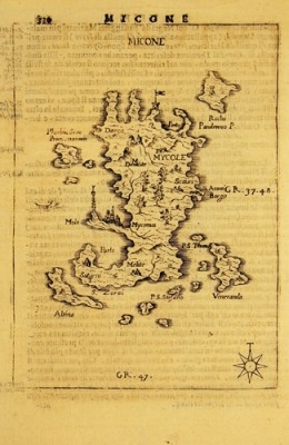
1688réf. GRA085Copper engraved maps from "L' Egeo redivivo ... CHRONOGRAPHIA dell'ARCHIPELAGO", Modena 1688, each map approximately engraved surface 17 x 12 cm with their corresponding italian text on their back. Clean plates. Each map
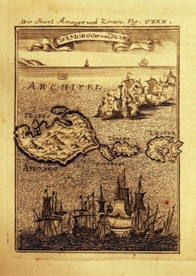
réf. GRA075Copper plate engravings from 'Beschreibung des gantzen Welt-Kreises' Frankfurt 1684/85 und 1719 (Description de l’Univers..) Engraved surface c. 15 X 10,2 cm, clean plates all decorated with ships. Each
réf. FO027Original photographs on hard board, contemp. hand-writing on the margins. 1. 37,6 x 27 cm = 750.- euros 2. 26 x 20 cm =500.- 3. 26 x 21 cm = 500.-euros
1688réf. GRA079Copper engraved maps from "L' Egeo redivivo ... CHRONOGRAPHIA dell'ARCHIPELAGO", Modena 1688, each map approximately engraved surface 17 x 12 cm with their corresponding italian text on their back. Clean plates. Each map
1688réf. GRA84Copper engraved maps from "L' Egeo redivivo ... CHRONOGRAPHIA dell'ARCHIPELAGO", Modena 1688, each map approximately engraved surface 17 x 12 cm with their corresponding italian text on their back. Clean plates. Each map
1688réf. GRA080Copper engraved maps from "L' Egeo redivivo ... CHRONOGRAPHIA dell'ARCHIPELAGO", Modena 1688, each map approximately engraved surface 17 x 12 cm with their corresponding italian text on their back. Clean plates. Each map
réf. GRA076Copper plate engravings from 'Beschreibung des gantzen Welt-Kreises' Frankfurt 1684/85 und 1719 (Description de l’Univers..) Engraved surface c. 15 X 10,2 cm, clean plates all decorated with ships. Each
1686réf. GRA081Copper engraved maps from "L' Egeo redivivo ... CHRONOGRAPHIA dell'ARCHIPELAGO", Modena 1688, each map approximately engraved surface 17 x 12 cm with their corresponding italian text on their back. Clean plates. Each map
1686réf. GRA083Copper engraved maps from "L' Egeo redivivo ... CHRONOGRAPHIA dell'ARCHIPELAGO", Modena 1688, each map approximately engraved surface 17 x 12 cm with their corresponding italian text on their back. Clean plates. Each map
réf. GRA077Copper plate engravings from 'Beschreibung des gantzen Welt-Kreises' Frankfurt 1684/85 und 1719 (Description de l’Univers..) Engraved surface c. 15 X 10,2 cm, clean plates all decorated with ships. Each