5 141 résultats
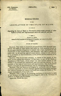
1844réf. 36140Washington D.C.: n.p. 1844. First edition. Removed. A very good copy. 1 pp. 8vo. The Maine resolution was an attack on the heinous process of re-enslaving freed blacks: "Resolved. That we do most solemnly in behalf of the people of this State protest against the existence of any laws in any of the States of Territories of this Union which subject our free colored citizens to the liability to be arrested and imprisoned and to be sold into slavery for the payment of the costs of such arrest and imprisonment; that we do protest against such laws as unconstitutional and as endangering the Union." Maine approved this on March 22 1843 sent a copy to all members of the House and Senate and to all the governors of States and Territories. OCLC locates no copies. Not in Sabin Blockson Dumont Work LCP. Afro-Americana Clark: New England in U.S. Government Publications 1789-1849: 1145. n.p. unknown books
1920réf. 41288Washington D.C.: Published by the United States Coast and Geodetic Survey 1920. Large folding nautical chart printed on heavy paper stock. Colored. A rare original coastal survey of Portsmouth Harbor including Kittery Point New Castle Island and Portsmouth. Established by President Thomas Jefferson in 1807 as the Survey of the Coast the U.S. Coast and Geodetic Survey was the United States' first civilian scientific agency. This agency has followed its mission to survey the U.S. coastline create nautical charts of the coast and help increase maritime safety since its founding and has often played fascinating roles in significant chapters of U.S. history. It served in all theaters of the Civil War in the service of the Union Army and Navy pioneered acoustic exploration in the wake of the sinking of the Titanic and during WWI it worked to detect enemy submarines. In addition this agency worked to survey and produce detailed maps and renderings of the U.S. coast. These nautical survey maps commonly referred to as "T-sheets" provide fascinating insights into the history of the United States coastline which has and will continue to shift. These maps are the most important data source for understanding the physical and ecological characteristics of the U.S. shoreline. The present map is a highly detailed and accurate sea chart of Portsmouth Harbor and an important historical view of developing New Hampshire and Maine. Published by the United States Coast and Geodetic Survey unknown
1920réf. 41288Washington D.C.: Published by the United States Coast and Geodetic Survey 1920. Large folding nautical chart printed on heavy paper stock. Colored. A rare original coastal survey of Portsmouth Harbor including Kittery Point New Castle Island and Portsmouth. Established by President Thomas Jefferson in 1807 as the Survey of the Coast the U.S. Coast and Geodetic Survey was the United States' first civilian scientific agency. This agency has followed its mission to survey the U.S. coastline create nautical charts of the coast and help increase maritime safety since its founding and has often played fascinating roles in significant chapters of U.S. history. It served in all theaters of the Civil War in the service of the Union Army and Navy pioneered acoustic exploration in the wake of the sinking of the Titanic and during WWI it worked to detect enemy submarines. In addition this agency worked to survey and produce detailed maps and renderings of the U.S. coast. These nautical survey maps commonly referred to as "T-sheets" provide fascinating insights into the history of the United States coastline which has and will continue to shift. These maps are the most important data source for understanding the physical and ecological characteristics of the U.S. shoreline. The present map is a highly detailed and accurate sea chart of Portsmouth Harbor and an important historical view of developing New Hampshire and Maine. Published by the United States Coast and Geodetic Survey unknown books
1922réf. 41276Washington D.C.: Published by the United States Coast and Geodetic Survey 1922. Large folding nautical chart printed on heavy paper stock. Colored. Bisected into two maps. A rare original coastal survey of Maine including Boothbay Harbor Bath and Georgetown. Established by President Thomas Jefferson in 1807 as the Survey of the Coast the U.S. Coast and Geodetic Survey was the United States' first civilian scientific agency. This agency has followed its mission to survey the U.S. coastline create nautical charts of the coast and help increase maritime safety since its founding and has often played fascinating roles in significant chapters of U.S. history. It served in all theaters of the Civil War in the service of the Union Army and Navy pioneered acoustic exploration in the wake of the sinking of the Titanic and during WWI it worked to detect enemy submarines. In addition this agency worked to survey and produce detailed maps and renderings of the U.S. coast. These nautical survey maps commonly referred to as "T-sheets" provide fascinating insights into the history of the United States coastline which has and will continue to shift. These maps are the most important data source for understanding the physical and ecological characteristics of the U.S. shoreline. The present map is a highly detailed and accurate sea chart of coastal Maine from Boothbay Harbor to Bath and an important historical view of the developing state. Published by the United States Coast and Geodetic Survey unknown
1922réf. 41276Washington D.C.: Published by the United States Coast and Geodetic Survey 1922. Large folding nautical chart printed on heavy paper stock. Colored. Bisected into two maps. A rare original coastal survey of Maine including Boothbay Harbor Bath and Georgetown. Established by President Thomas Jefferson in 1807 as the Survey of the Coast the U.S. Coast and Geodetic Survey was the United States' first civilian scientific agency. This agency has followed its mission to survey the U.S. coastline create nautical charts of the coast and help increase maritime safety since its founding and has often played fascinating roles in significant chapters of U.S. history. It served in all theaters of the Civil War in the service of the Union Army and Navy pioneered acoustic exploration in the wake of the sinking of the Titanic and during WWI it worked to detect enemy submarines. In addition this agency worked to survey and produce detailed maps and renderings of the U.S. coast. These nautical survey maps commonly referred to as "T-sheets" provide fascinating insights into the history of the United States coastline which has and will continue to shift. These maps are the most important data source for understanding the physical and ecological characteristics of the U.S. shoreline. The present map is a highly detailed and accurate sea chart of coastal Maine from Boothbay Harbor to Bath and an important historical view of the developing state. Published by the United States Coast and Geodetic Survey unknown books
1920réf. 41287Washington D.C.: Published by the United States Coast and Geodetic Survey 1920. Large folding nautical chart printed on heavy paper stock. Colored. A rare original coastal survey of Maine at East Penobscot Bay including the Fox Islands Deer Isle Stonington and Isle Au Hunt. Established by President Thomas Jefferson in 1807 as the Survey of the Coast the U.S. Coast and Geodetic Survey was the United States' first civilian scientific agency. This agency has followed its mission to survey the U.S. coastline create nautical charts of the coast and help increase maritime safety since its founding and has often played fascinating roles in significant chapters of U.S. history. It served in all theaters of the Civil War in the service of the Union Army and Navy pioneered acoustic exploration in the wake of the sinking of the Titanic and during WWI it worked to detect enemy submarines. In addition this agency worked to survey and produce detailed maps and renderings of the U.S. coast. These nautical survey maps commonly referred to as "T-sheets" provide fascinating insights into the history of the United States coastline which has and will continue to shift. These maps are the most important data source for understanding the physical and ecological characteristics of the U.S. shoreline. The present map is a highly detailed and accurate sea chart of East Penobscot Bay and an important historical view of developing Maine. Published by the United States Coast and Geodetic Survey unknown
1920réf. 41287Washington D.C.: Published by the United States Coast and Geodetic Survey 1920. Large folding nautical chart printed on heavy paper stock. Colored. A rare original coastal survey of Maine at East Penobscot Bay including the Fox Islands Deer Isle Stonington and Isle Au Hunt. Established by President Thomas Jefferson in 1807 as the Survey of the Coast the U.S. Coast and Geodetic Survey was the United States' first civilian scientific agency. This agency has followed its mission to survey the U.S. coastline create nautical charts of the coast and help increase maritime safety since its founding and has often played fascinating roles in significant chapters of U.S. history. It served in all theaters of the Civil War in the service of the Union Army and Navy pioneered acoustic exploration in the wake of the sinking of the Titanic and during WWI it worked to detect enemy submarines. In addition this agency worked to survey and produce detailed maps and renderings of the U.S. coast. These nautical survey maps commonly referred to as "T-sheets" provide fascinating insights into the history of the United States coastline which has and will continue to shift. These maps are the most important data source for understanding the physical and ecological characteristics of the U.S. shoreline. The present map is a highly detailed and accurate sea chart of East Penobscot Bay and an important historical view of developing Maine. Published by the United States Coast and Geodetic Survey unknown books
1920réf. 41284Washington D.C.: Published by the United States Coast and Geodetic Survey 1920. Large folding nautical chart printed on heavy paper stock. Colored. A rare original coastal survey of the Kennebec and Sheepscot Rivers including Bath Georgetown Boothbay and Wiscasset. Established by President Thomas Jefferson in 1807 as the Survey of the Coast the U.S. Coast and Geodetic Survey was the United States' first civilian scientific agency. This agency has followed its mission to survey the U.S. coastline create nautical charts of the coast and help increase maritime safety since its founding and has often played fascinating roles in significant chapters of U.S. history. It served in all theaters of the Civil War in the service of the Union Army and Navy pioneered acoustic exploration in the wake of the sinking of the Titanic and during WWI it worked to detect enemy submarines. In addition this agency worked to survey and produce detailed maps and renderings of the U.S. coast. These nautical survey maps commonly referred to as "T-sheets" provide fascinating insights into the history of the United States coastline which has and will continue to shift. These maps are the most important data source for understanding the physical and ecological characteristics of the U.S. shoreline. The present map is a highly detailed and accurate sea chart of the Kennebec and Sheepscot Rivers and an important historical view of developing Maine. Published by the United States Coast and Geodetic Survey unknown
1920réf. 41284Washington D.C.: Published by the United States Coast and Geodetic Survey 1920. Large folding nautical chart printed on heavy paper stock. Colored. A rare original coastal survey of the Kennebec and Sheepscot Rivers including Bath Georgetown Boothbay and Wiscasset. Established by President Thomas Jefferson in 1807 as the Survey of the Coast the U.S. Coast and Geodetic Survey was the United States' first civilian scientific agency. This agency has followed its mission to survey the U.S. coastline create nautical charts of the coast and help increase maritime safety since its founding and has often played fascinating roles in significant chapters of U.S. history. It served in all theaters of the Civil War in the service of the Union Army and Navy pioneered acoustic exploration in the wake of the sinking of the Titanic and during WWI it worked to detect enemy submarines. In addition this agency worked to survey and produce detailed maps and renderings of the U.S. coast. These nautical survey maps commonly referred to as "T-sheets" provide fascinating insights into the history of the United States coastline which has and will continue to shift. These maps are the most important data source for understanding the physical and ecological characteristics of the U.S. shoreline. The present map is a highly detailed and accurate sea chart of the Kennebec and Sheepscot Rivers and an important historical view of developing Maine. Published by the United States Coast and Geodetic Survey unknown books
1929réf. 41282Washington D.C.: Published by the United States Coast and Geodetic Survey 1929. Large folding nautical chart printed on heavy paper stock. Colored. A rare original coastal survey of Maine from Monhegan Island to Cape Elizabeth including Bristol Damariscotta Wiscasset Boothbay Georgetown Harpswell Bath Brunswick Freeport Yarmouth and Portland. Established by President Thomas Jefferson in 1807 as the Survey of the Coast the U.S. Coast and Geodetic Survey was the United States' first civilian scientific agency. This agency has followed its mission to survey the U.S. coastline create nautical charts of the coast and help increase maritime safety since its founding and has often played fascinating roles in significant chapters of U.S. history. It served in all theaters of the Civil War in the service of the Union Army and Navy pioneered acoustic exploration in the wake of the sinking of the Titanic and during WWI it worked to detect enemy submarines. In addition this agency worked to survey and produce detailed maps and renderings of the U.S. coast. These nautical survey maps commonly referred to as "T-sheets" provide fascinating insights into the history of the United States coastline which has and will continue to shift. These maps are the most important data source for understanding the physical and ecological characteristics of the U.S. shoreline. The present map is a highly detailed and accurate sea chart of coastal Maine around Portland and an important historical view of the developing state. Published by the United States Coast and Geodetic Survey unknown
1929réf. 41282Washington D.C.: Published by the United States Coast and Geodetic Survey 1929. Large folding nautical chart printed on heavy paper stock. Colored. A rare original coastal survey of Maine from Monhegan Island to Cape Elizabeth including Bristol Damariscotta Wiscasset Boothbay Georgetown Harpswell Bath Brunswick Freeport Yarmouth and Portland. Established by President Thomas Jefferson in 1807 as the Survey of the Coast the U.S. Coast and Geodetic Survey was the United States' first civilian scientific agency. This agency has followed its mission to survey the U.S. coastline create nautical charts of the coast and help increase maritime safety since its founding and has often played fascinating roles in significant chapters of U.S. history. It served in all theaters of the Civil War in the service of the Union Army and Navy pioneered acoustic exploration in the wake of the sinking of the Titanic and during WWI it worked to detect enemy submarines. In addition this agency worked to survey and produce detailed maps and renderings of the U.S. coast. These nautical survey maps commonly referred to as "T-sheets" provide fascinating insights into the history of the United States coastline which has and will continue to shift. These maps are the most important data source for understanding the physical and ecological characteristics of the U.S. shoreline. The present map is a highly detailed and accurate sea chart of coastal Maine around Portland and an important historical view of the developing state. Published by the United States Coast and Geodetic Survey unknown books
réf. a90759Seventy original manuscript receipts. Most 3 or 4 x 8 a few larger a few smaller. A few with a bit of printed information store name location etc. Most concern sea Captains Michael Small David Haskell Frederick Spofford Thomas Spofford Jonathan Haskell Nathan Haskell. Schooner Olin is mentioned several times. Most concern taxes or purchase of supplies. Many give location as Deer Isle Maine A few Boston or nearby. Dates on documents range from 1815 to 1850. G to VG. Loose in folder. . unknown
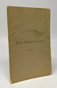
1879réf. 11869Augusta ME: George E. Nason Printer 1879. First Edition. Softcover. Very good. Octavo 77pp. A clean sound very good copy in the publisher's printed wraps. Long tear and crease to the rear wrap with one small hole affecting the last leaf with no text. Two contemporary library labels internally not at all offensive. A vanishingly scarce volume recording the proceedings of some early reunions of the First Maine Cavalry regiment. Detailed reminiscences of the war make up much of the contents as well as some soldier-authored poetry and some administrative business. As with many cavalry regiments the First Maine saw significant action from the beginning to the end of the war at too many battles to list but including at Gettysburg and in Sheridan's final campaign through Virginia. OCLC notes a single holding at AAS. Ephemeral and considerably rarer than the two regularly published regimental histories of the regiment which both command strong prices in the rare book market. George E. Nason, Printer unknown
réf. 2111902154800122Akihiro shobo N.A. Soft Cover. Fine. The book is in fine condition. Akihiro shobo paperback
1961réf. 26558London: Hodder and Stoughton. Near Fine in Near Fine dj. 1961. First Edition. Hardcover. price-clipped nice tight clean copy just the teensiest bumping to the lower front corner; the jacket is virtually flawless downgraded from Fine only because of the price-clipping and a touch of soiling to the rear panel. "John Soames is thirty years old and physiologically speaking alive. But by some trick of fate he has never become conscious. He is awoken and brought to full consciousness by a surgeon's knife a newborn baby with the body of a healthy young man." Basis for the 1970 British-American film of the same name starring Terence Stamp and Robert Vaughn; a critical and box-office disappointment on its original release the film has gained a bit of a retrospective cult reputation with one online critic calling it "a dark gem and a worthy pretender to the British horror hall of fame." Uncommon in the first edition all the more so in such outstanding condition. . Hodder and Stoughton hardcover
1961réf. 26558London: Hodder and Stoughton. Near Fine in Near Fine dj. 1961. First Edition. Hardcover. price-clipped nice tight clean copy just the teensiest bumping to the lower front corner; the jacket is virtually flawless downgraded from Fine only because of the price-clipping and a touch of soiling to the rear panel. "John Soames is thirty years old and physiologically speaking alive. But by some trick of fate he has never become conscious. He is awoken and brought to full consciousness by a surgeon's knife a newborn baby with the body of a healthy young man." Basis for the 1970 British-American film of the same name starring Terence Stamp and Robert Vaughn; a critical and box-office disappointment on its original release the film has gained a bit of a retrospective cult reputation with one online critic calling it "a dark gem and a worthy pretender to the British horror hall of fame." Uncommon in the first edition all the more so in such outstanding condition. . Hodder and Stoughton hardcover books
1938réf. 9734London: John Murray 1938. Sara Delano Roosevelt's copy of her son's biography with her initials "SDR" in pencil to the front free end paper from the collection of Frederick Baldwin Adams a relative of FDR and his mother. Sara Delano Roosevelt clearly read the book with close interest as indicated by the marginal pencil lines scattered throughout the text. As these annotations are fairly extensive albeit heavily concentrated in the latter two-thirds of the book which concentrate on F.D.R.'s political career 1910s-1930s it is difficult to identify Sara's precise points of interest although there is the odd occurrence. For example on p.96 a less-encountered double-line is pencilled next to a sentence regarding F.D.R.'s embarkation on a new destroyer the Dyer during the First World War on which occasion "since he was sailing under secret orders neither his wife nor his mother could see him off" perhaps a difficult memory that stuck in Sara's mind. More broadly sections concerning family friends and commentary regarding F.D.R.'s political achievements appear to have elicited the most interest. A touching relic indicative of Sara's famous devotion and steadfast support for her son whom she lived to see elected three times as President of the United States. An account of the life and character of President Franklin Delano Roosevelt by family friend writer and music critic Basil Maine 1894-1972. The present copy comes from the Franklin Delano Roosevelt collection of Frederick Baldwin Adams Jr 1910-2001 the son of Ellen Walters Delano who was a first cousin to President Roosevelt. Adams became a passionate bibliophile who served as director of the Pierpont Morgan Library in New York City for two decades and compiled a significant personal collection relating to F.D.R. In 1969 he married his third wife who was a Swedish princess and with whom he shared the final years of his life in France. Adams' move to France explains the presence of his books in the United Kingdom. First edition. Publisher's original pink cloth with titles in gilt to the spine. Illustrated with nine black and white photographs. Panels of the original dustwrapper loosely laid in along with a newspaper obituary of Sir Sayaji Rao Indian ruler of Baroda who was a guest at the White House in 1934. A very good copy the binding square and firm with a little fading to the spine. The contents with toning to two text pages resulting from the insertion of the newspaper cutting are otherwise excellent throughout. Please contact Christian White Rare Books Ltd for more information or images of this item 1938 John Murray hardcover
réf. 013517Nicolas Oudinot (1791-1863), général, député du Maine et Loire, commandant de l'expédition italienne de 1849. L.A.S., Grenoble, 26 octobre 1848, 4p in-4. Très importante et intéressante lettre à un haut responsable piémontais à Turin, probablement un personnage de l'importance de Vittorio Colli de Felizzano (1787-1856), homme politique et militaire important du royaume de Sardaigne alors en poste à Turin. Dans cette très longue lettre, il regrette de ne pouvoir donner les renseignements demandés, mentionne le « moral des troupes autrichiennes [qui] doit être fortement ébranlé par les événements survenus dans la mère patrie » sans pour autant penser que les piémontais puissent en profiter. Il pense que « l'armée de Charles-Albert » a besoin d'alliés, « l'intervention française ne serait pas moins utile à mon Pays qu'au vôtre ; je la désire donc ; je souhaite ardemment que l'alliance de nos gouvernements se consolide de plus en plus ». Il précise aussi avoir envoyé un officier pour recueillir les renseignements de son correspondant. Très beau document autour de la formation de l'Italie. [304-2]
1845réf. 85130Paris Le Mans, Derache, Libraire, Gallienne, Imprimeur-Libraire, Le Mans 1845 Grand in-4. Reliure demi-basane vert moyen, dos lisse, filets à froid, 43-XCVI-735 pp., 1 carte repliée, IV planches contenant 91 figures de monnaies in fine. Reliure légèrement frottée, rousseurs éparses et marginales.
réf. a7828227 large-size all open to 4to letters. All in neat ink handwritting and signed. all original. Dated at Belfast January 20 - November 14 1831. All concern mutual marine business matters. The correspondence deals largely with various vessels - the Albert Mechanic Pres. Jackson and the Union - and their captains - John Schute Eastman Clark Vinal and Patterson. These men and their ships moved cargo ordered by Sullivan & Barbour. Thus: "We have shipped by the Pres. Jackson 1 Barrel Cheango Potatoes which you will please to accept - we think them better than any thing of the kind you get in Boston - and we should be pleased to supply you & and your friends at 3/ per bushel - which by & by you will not think an extravagent price as the crop is very short." On September 26th Philip Morrill writes "When in Boston I bought a gang of Rigging of Mssr J & J. Wilson - Capt. Barnes made arrangements to have the lower standing rigging fitted in Boston and gave Mssr. Wilson's directions to ship it by Schr. Dispatch Capt Couzens when called for - the Dispatch arrived yesterday bringing only the fitting rigging." Good to VG a few small holes due to sealing wax. Lot of 27 letters: . unknown
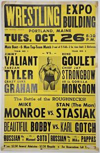
1971réf. BK0129Portland Maine: Jack Laurence promoter 1971. Large illustrated wrestling poster for an evening at the Expo Building 17 x 26 inches. Printed in black and yellow with central portrait of Tarzan Tyler. Light wear old folds and small losses at margins; very good. A locally produced wrestling poster for a 1971 card at Portland's Expo Building promoted by longtime Maine sports promoter Jack Laurence. The main event was a six-man tag-team match pitting Jimmy Valiant Tarzan Tyler and "Crazy" Luke Graham against Rene Goulet Chief Jay Strongbow and Gorilla Monsoon advertised as three out of five falls with a two-hour time limit and two referees. The undercard included "The Battle of the Roughnecks" Mike Monroe against Stan "The Man" Stasiak; "Beautiful Bobby" against Karl Gotch; and Manuel Soto and Mike Pappas billed as "The Russians." Tyler and Graham were then the WWWF tag champions while Monsoon Strongbow Valiant Gotch and Stasiak were among the promotion's familiar stars. The evening followed immediately after the October 25 Madison Square Garden card where many of the same wrestlers appeared: Monsoon defeated Monroe Gotch defeated Beautiful Bobby and Strongbow and Victor Rivera defeated Tyler and Graham.1 Interestingly this Portland event does not appear in the extensive published 1971 WWWF results compilation we consulted which records the October 25 Madison Square Garden event and then resumes with October 29 cards in Lowell and North Attleboro. The poster thus appears to provide primary documentation of an otherwise poorly recorded Maine card. Laurence whose name appears prominently as promoter died the following February. A memorial resolution of the Maine Legislature described him as one of the state's "most devoted and beloved sports promoters."2 1 Richard Land "WWWF - 1971 Results" The History of WWE accessed September 17 2026 https://thehistoryofwwe.com/wwwf-results-1971/. 2 Legislative Record of the One Hundred and Fifth Legislature of the State of Maine Vol. III June 16-June 24 1971 893. . Jack Laurence, promoter unknown
1971réf. BK0129Portland Maine: Jack Laurence promoter 1971. Large illustrated wrestling poster for an evening at the Expo Building 17 x 26 inches. Printed in black and yellow with central portrait of Tarzan Tyler. Light wear old folds and small losses at margins; very good. A locally produced wrestling poster for a 1971 card at Portland's Expo Building promoted by longtime Maine sports promoter Jack Laurence. The main event was a six-man tag-team match pitting Jimmy Valiant Tarzan Tyler and "Crazy" Luke Graham against Rene Goulet Chief Jay Strongbow and Gorilla Monsoon advertised as three out of five falls with a two-hour time limit and two referees. The undercard included "The Battle of the Roughnecks" Mike Monroe against Stan "The Man" Stasiak; "Beautiful Bobby" against Karl Gotch; and Manuel Soto and Mike Pappas billed as "The Russians." Tyler and Graham were then the WWWF tag champions while Monsoon Strongbow Valiant Gotch and Stasiak were among the promotion's familiar stars. The evening followed immediately after the October 25 Madison Square Garden card where many of the same wrestlers appeared: Monsoon defeated Monroe Gotch defeated Beautiful Bobby and Strongbow and Victor Rivera defeated Tyler and Graham.1 Interestingly this Portland event does not appear in the extensive published 1971 WWWF results compilation we consulted which records the October 25 Madison Square Garden event and then resumes with October 29 cards in Lowell and North Attleboro. The poster thus appears to provide primary documentation of an otherwise poorly recorded Maine card. Laurence whose name appears prominently as promoter died the following February. A memorial resolution of the Maine Legislature described him as one of the state's "most devoted and beloved sports promoters."2 1 Richard Land "WWWF - 1971 Results" The History of WWE accessed September 17 2026 https://thehistoryofwwe.com/wwwf-results-1971/. 2 Legislative Record of the One Hundred and Fifth Legislature of the State of Maine Vol. III June 16-June 24 1971 893. . Jack Laurence, promoter unknown books
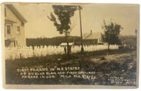
1923réf. 177341923. Clement Studio Ku Klux Klan march in Milo Maine 1923 documents the public visibility of the 1920s Klan revival in a rural Northeastern town. The image records the first daylight Ku Klux Klan parade and the first Klan parade in New England held during Milo's centennial celebration on September 3 1923. Its research value lies in its direct visual evidence of white supremacist performance anti-Catholic and anti-immigrant intimidation and the spread of Klan organizing beyond the South during the interwar period. Clement Studio. Ku Klux Klan march Milo Maine. Milo Maine: Clement Studio September 3 1923. Black-and-white silver gelatin real photo postcard. 5.25 x 3.5 inches. The photograph shows hooded Klansmen in white robes marching through Milo with several participants carrying American flags. The Metropolitan Museum of Art records a related Clement Studio image with the negative inscription: "First Parade in N.E. States of Ku Klux Klan. Milo. Maine Sept 3. 1923. Centennial Celebration." The photograph belongs to the period when the revived Klan used parades recruitment flags robes and public ceremony to normalize racial religious and nativist exclusion. In Maine Klan activity particularly targeted Catholic and immigrant communities including French Canadian and Irish populations while also drawing on national anti-Black anti-Jewish and anti-immigrant ideology. Minor small stain along upper margin not affecting image; very good. A stark local record of the Klan's Northeastern expansion and its use of daylight public spectacle as intimidation. unknown
1923réf. 177341923. Clement Studio Ku Klux Klan march in Milo Maine 1923 documents the public visibility of the 1920s Klan revival in a rural Northeastern town. The image records the first daylight Ku Klux Klan parade and the first Klan parade in New England held during Milo's centennial celebration on September 3 1923. Its research value lies in its direct visual evidence of white supremacist performance anti-Catholic and anti-immigrant intimidation and the spread of Klan organizing beyond the South during the interwar period. Clement Studio. Ku Klux Klan march Milo Maine. Milo Maine: Clement Studio September 3 1923. Black-and-white silver gelatin real photo postcard. 5.25 x 3.5 inches. The photograph shows hooded Klansmen in white robes marching through Milo with several participants carrying American flags. The Metropolitan Museum of Art records a related Clement Studio image with the negative inscription: "First Parade in N.E. States of Ku Klux Klan. Milo. Maine Sept 3. 1923. Centennial Celebration." The photograph belongs to the period when the revived Klan used parades recruitment flags robes and public ceremony to normalize racial religious and nativist exclusion. In Maine Klan activity particularly targeted Catholic and immigrant communities including French Canadian and Irish populations while also drawing on national anti-Black anti-Jewish and anti-immigrant ideology. Minor small stain along upper margin not affecting image; very good. A stark local record of the Klan's Northeastern expansion and its use of daylight public spectacle as intimidation. unknown books
1781réf. 49841781 Paris Lattré 1781-1791 5 cartes anciennes. Env. 30 x 41,5 cm hors marges, 36,5 x 51 cm toutes marges comprises. Frontières rehaussées. Bonnes conditions. Quelques menues déchirures marginales à certaines cartes. Pliure partiellement fendue à la carte du Dauphiné et de la Provence.