BERRY, WilliamBiblio.com
9579 risultati
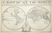
rif. 7758London: William Berry at ye Sign of the Globe between Charing Cross and Whitehall. 1680. No binding. Good. 575 x 885 mm. two sheets joined in early outline colour some professional repair to edge tears and reinforcement to lower corners not affecting the image with the accompanying page of geographical tables otherwise in good condition. A fine rare English double-hemispheric seventeenth century world map. In September 1678 Robert Morden fl. 1669 d. 1703 and William Berry 1639-1718 petitioned the crown for 'a licence to do all general and particular maps of the several parts of the world according to an alphabeticall manner'. Morden's connection with what appears to be the birth of the folio atlas is not heard of again. Berry began publishing a series of large two sheet maps with a group of the world and continents advertised in the 'London Gazette' from 1-5 July 1680. The world is also announced in the 'Term Catalogues' for the summer of that year. This only mentions the world map which would undoubtedly have been finished first and the continents would have followed. Berry did not advertise his next two sheet map that of England until February 1682. 'Through the 1680s Berry published nearly forty large maps of parts of the world sufficient to cover it all. From the late 1680s he clearly offered them bound together as a collection of maps as a handful of examples are known but this was clearly not the intention for the maps as none have borne any title page. Examples are known in the British Library the Library of Congress and the National Maritime Museum Greenwich all bearing either thirty-seven or thirty-eight maps. An example has been noted for sale by Maggs Brothers which bore sixty-nine maps the balance being made up of contemporary English maps by other cartographers dating the atlas to c.1704 and two further offered at Christies auctions in London in the 1980s' Burden. Cartographically the world map is drawn directly from that of Alexis-Hubert Jaillot 1674. Jaillot's map was in turn derived from Nicolas Sanson's geography who is here recognised in the running title above 'Described by Sanson Corrected and amended By William Berry'. Sanson had far more of a reputation in cartographic circles than Jaillot so it is natural that Berry would use his name. These 'amendments' include the patriotically named islands off Tierra del Fuego and 'New Albion' placed in California. New Guinea is distinctly an island and there is no southern continent. An ornate cartouche lower centre includes an effusive dedication to Charles II. Armitage 2012 pp. 41 & 99-100; Burden 1996-2007 532; Phillips 1909- 3442; Shirley 1984 501; Shirley 2004 T.Berr 1a; Tyacke 1973 p. 76; Tyacke 1978 no. 100 & pp. 109-10. William Berry at ye Sign of the Globe between Charing Cross and Whitehall. 1680 unknown
1996rif. SBBIH-SQOPSSUQK7XTMerlin Books Ltd 1996. paperback. Good. Our good condition books are generally good for reading but not for gifting or collecting. They could have imperfections such as creasing fanning inscriptions margin notes yellowing staining on edge or cover or pages bumps scuffs etc etc sometimes multiple of these. It's a wide category that encompasses anything that isn't almost-new down to anything that is slightly better than poor. We would NOT recommend gifting Good books - these should be considered reading copies. Our books are dispatched from a Yorkshire former cotton mill. We list via barcode/ISBN so please note that the images are stock images and may not be the exact copy you receive furthermore the details about edition and year might not be accurate as many publishers reuse the same ISBN for multiple editions and as we simply scan a barcode or enter an ISBN we do not check the validity of the edition data when listing. If you're looking for an exact edition please don't order at least not without checking with us first although we don't always have time to check. We aim to dispatch prompty the service used will depend on order value and book size. We can ship to most countries see our shipping policies. Payment is via Abe only. Merlin Books Ltd paperback
2003rif. 42820840Pre-publication printout. 2 356 pp. the published work was 446 pp. Comb-bound. Very good condition. Presentation copy inscribed by James Watson to Francis Crick and his wife: "For Francis and Odile from Jim 27 November 2002." This is the dedication copy with the printed dedication stating "To Francis Crick." Crick's wife Odile co-recipient of this presentation copy is famous for her drawing of the DNA molecule published in Nature in April 1953 and subsequently widely reproduced in textbooks scientific articles and popular literature. "It may be the most famous scientific drawing of the 20th century in that it defines modern biology" Terrence J. Sejnowski Salk Institute. "A remarkable alignment of the planets is occurring in 2003: the 50th anniversary of the double helix and the completion of the sequence of the human genome. As a defining figure in both land- mark events no other human being on the planet is positioned to write as authoritatively about all this as Jim Watson. In DNA: The Secret of Life he does so with clarity style and wit. If you really want to know what happened in the most important half-century of biology since the world began read this" Francis Collins. This splendid presentation copy represents the greatest scientific collaboration of the 20th century. The names Watson and Crick will forever be linked in the history of science. Provenance: Francis and Odile Crick inscribed to them by James Watson. [New York: Knopf] paperback
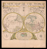
1680rif. 18434London: Sold by Will Berry at the Signe of the Globe between Chearing-Cross and White-Hall c1680. 425 by 480mm 16.75 by 19 inches. The first polar projection world map published by an Englishman Engraved map fine original hand-colour Ptolemaic Tychonic and Copernican diagrams of the solar system around map map of the ancient world below. The first world map on polar projection to be published by an Englishman. Polar Projection Polar projection is a type of azimuthal projection based on a plane perpendicular to the Earth's axis through the poles. On polar-centered azimuthal projections longitude is represented by radial straight lines and latitude by concentric circles or parallels. One of the earliest examples of a polar map of this kind is Mercator's 1569 world map on which the Arctic is shown in an inset map on a polar projection rather than included as part of the main image on the eponymous cartographer's projection. Other early double hemisphere world maps on north and south polar projections include Gerard De Jode's Hemispheriu ab Aequinoctiali Linea 1593; Isaac Habrecht's map of 1628; Janssonius' Typus Orbis Terrarum from the same year; Jean Boisseau's Nouvelle Description de toute la terre universelle of 1640; and Novus Planiglobe Terrestris Per Utrumque Polum Conspectus engraved by Joan Blaeu before 1672 the only extant example of which bears the later imprint of Gerard Valck published around 1695. The present map by Berry is an example of the first map on polar projection to be published by an Englishman. The Map Published around 1680 Berry's map shows both the north and south hemispheres on a polar projection at a scale of approximately 1:100000000 with both extending to the equator which is scaled. The coast of Australia is incomplete and California is shown as an island. Other cartographic myths include the massive single Great Lake and the Straits of Anian. The sizes of the Philippines and Japan are exaggerated and the southern tip of South America has been truncated due to the projection. At first glance the work would appear to be a copy of Blaeu/Valck Novus Planiglobe Terrestris Per Utrumque Polum Conspectus; and although Berry's English title is an almost direct translation of Blaeu's work it is no merely slavish copy. Berry has reversed the hemispheres and significant cartographic differences are evident especially in the depiction of South America. Surrounding the hemispheres are cosmological diagrams showing the Ptolemaic Copernican and Tychonic solar systems as well as a smaller map of the ancient world. This shows only Europe Asia and Africa and is divided into layers of "temperate zone" "frozen zone" "unhabitable" and "habitable by the Antients" regions. Ribbons ornament the upper left- and right-hand corners streaming from the ends of the simple title banner along the upper edge. The map was engraved by John Rich who also executed his road map of Great Britain the year before. William Berry 1639-1718 In his Printed Maps in the Atlases of Great Britain and Ireland 15791870 Thomas Chubb describes Berry as a bookseller geographer and engraver who was active between about 1670 and 1703. Berry was the son of a Warwickshire baker probably apprenticed alongside his future partner Robert Morden c1650-1703 to Joseph Moxon 16271691 an engraver mapmaker globe-maker and instrument-maker. His most enduring partnership was later with Morden and together they sold topographical works prints maps charts and globes. Among their shared works were A New Map of the English Plantations in America 1673 William Leybourn's An introduction to astronomy and geography: being a plain and easie treatise of the globes 1675 and Playing cards depicting the Counties 1676. In 1677 they petitioned the Attorney General for "a licence to do all general and particular maps of the several parts of the world according to an alphabetical manner and method first projected by them against any other undertakers". Although there are individual maps and globes prepared by the pair the larger project never came to fruition although Berry is best remembered as the "English Sanson" for the set of maps of the world that he corrected and amended after Nicolas Sanson which were issued separately between 1680 and 1689. Rare we are only able to trace one institutional example held at The Library of Congress and a smaller facsimile at the British Library. Not in Shirley; LC G3200 1675 .B4. Sold by Will Berry at the Signe of the Globe between Chearing-Cross and White-Hall,