9 586 résultats
1830réf. 124608London: Newton Son & Berry c. 1830-1836. Fine pair of rare early 19th century celestial and terrestrial table globes published by Newton Son & Berry. Both the celestial and terrestrial globe measure 12 inches in diameter with a calibrated brass meridian ring and 19 inch mahogany horizon ring decorated with mounted hand colored decorations. Mounted on ebonized oak stands. Each globe is comprised of 12 richly detailed hand-colored gores with polar calottes the terrestrial globe detailing the earth's landmasses major countries and cities and the celestial showing the major stars in various sizes related to their brightness displayed with a table of magnitudes. Major constellations and all twelve zodiac signs are illustrated with detailed hand-colored drawings. The cartouche on the celestial globe is inscribed "Newton's New & Improved Celestial Globe On which all the Stars Nebulae & Clusters contained in the extensive Catalogue of the late E. Wollaston E.R.S. are accurately laid down their Right Ascensions and Declinations having been recalculated for the Year 1830 by W. Newton. Manufactured by Newton Son & Berry Chancery Lane London Published 1836." In near fine condition with some light restoration. Each globe measures 19 inches tall. The sphericity of the Earth was established by Greek astronomers in the 3rd century BC with the earliest terrestrial globe appearing during that period. The earliest known globe was constructed by Crates of Mallus in Cilicia now Cukurova in modern-day Turkey in the mid-2nd century B.C.E. Now known as the Erdapfel the earliest extant terrestrial globe was produced in 1492 by German mapmaker navigator and merchant Martin Behaim in Nuremberg Germany. Traditionally globes were manufactured by gluing a printed paper map onto a sphere often made from wood. Newton, Son & Berry unknown books
2003réf. 42820840Pre-publication printout. 2 356 pp. the published work was 446 pp. Comb-bound. Very good condition. Presentation copy inscribed by James Watson to Francis Crick and his wife: "For Francis and Odile from Jim 27 November 2002." This is the dedication copy with the printed dedication stating "To Francis Crick." Crick's wife Odile co-recipient of this presentation copy is famous for her drawing of the DNA molecule published in Nature in April 1953 and subsequently widely reproduced in textbooks scientific articles and popular literature. "It may be the most famous scientific drawing of the 20th century in that it defines modern biology" Terrence J. Sejnowski Salk Institute. "A remarkable alignment of the planets is occurring in 2003: the 50th anniversary of the double helix and the completion of the sequence of the human genome. As a defining figure in both land- mark events no other human being on the planet is positioned to write as authoritatively about all this as Jim Watson. In DNA: The Secret of Life he does so with clarity style and wit. If you really want to know what happened in the most important half-century of biology since the world began read this" Francis Collins. This splendid presentation copy represents the greatest scientific collaboration of the 20th century. The names Watson and Crick will forever be linked in the history of science. Provenance: Francis and Odile Crick inscribed to them by James Watson. [New York: Knopf] paperback
1930réf. 1000301930. Oil on canvas. 28 x 23 inches. Oil on canvas. 28 x 23 inches. Original 1930s Magazine Artwork. unknown books
1938réf. 1000331938. Oil on canvas mounted on foamboard signed lower right and dated '38. 32 x 24 inches. Oil on canvas mounted on foamboard signed lower right and dated '38. 32 x 24 inches. Original 1930s Magazine Artwork. unknown books
1937réf. 1000311937. Oil on canvas signed lower right and dated '37. 39 x 27 inches. Oil on canvas signed lower right and dated '37. 39 x 27 inches. Original 1930s Magazine Artwork. unknown books
1937réf. 1000321937. Oil on canvas signed lower right and dated '37. 42 x 27-1/2 inches. Oil on canvas signed lower right and dated '37. 42 x 27-1/2 inches. Original 1930s Magazine Artwork. unknown books
1996réf. SBBI-L-BBQ00827-RAG-20241Merlin Books Ltd 1996. paperback. Good. Our good condition books are generally good for reading but not for gifting or collecting. They could have imperfections such as creasing fanning inscriptions margin notes yellowing staining on edge or cover or pages bumps scuffs etc etc sometimes multiple of these. It's a wide category that encompasses anything that isn't almost-new down to anything that is slightly better than poor. We would NOT recommend gifting Good books - these should be considered reading copies. Our books are dispatched from a Yorkshire former cotton mill. We list via barcode/ISBN so please note that the images are stock images and may not be the exact copy you receive furthermore the details about edition and year might not be accurate as many publishers reuse the same ISBN for multiple editions and as we simply scan a barcode or enter an ISBN we do not check the validity of the edition data when listing. If you're looking for an exact edition please don't order at least not without checking with us first although we don't always have time to check. We aim to dispatch prompty the service used will depend on order value and book size. We can ship to most countries see our shipping policies. Payment is via Abe only. Merlin Books Ltd paperback
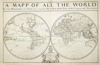
réf. 7758London: William Berry at ye Sign of the Globe between Charing Cross and Whitehall. 1680. No binding. Good. 575 x 885 mm. two sheets joined in early outline colour some professional repair to edge tears and reinforcement to lower corners not affecting the image with the accompanying page of geographical tables otherwise in good condition. A fine rare English double-hemispheric seventeenth century world map. In September 1678 Robert Morden fl. 1669 d. 1703 and William Berry 1639-1718 petitioned the crown for 'a licence to do all general and particular maps of the several parts of the world according to an alphabeticall manner'. Morden's connection with what appears to be the birth of the folio atlas is not heard of again. Berry began publishing a series of large two sheet maps with a group of the world and continents advertised in the 'London Gazette' from 1-5 July 1680. The world is also announced in the 'Term Catalogues' for the summer of that year. This only mentions the world map which would undoubtedly have been finished first and the continents would have followed. Berry did not advertise his next two sheet map that of England until February 1682. 'Through the 1680s Berry published nearly forty large maps of parts of the world sufficient to cover it all. From the late 1680s he clearly offered them bound together as a collection of maps as a handful of examples are known but this was clearly not the intention for the maps as none have borne any title page. Examples are known in the British Library the Library of Congress and the National Maritime Museum Greenwich all bearing either thirty-seven or thirty-eight maps. An example has been noted for sale by Maggs Brothers which bore sixty-nine maps the balance being made up of contemporary English maps by other cartographers dating the atlas to c.1704 and two further offered at Christies auctions in London in the 1980s' Burden. Cartographically the world map is drawn directly from that of Alexis-Hubert Jaillot 1674. Jaillot's map was in turn derived from Nicolas Sanson's geography who is here recognised in the running title above 'Described by Sanson Corrected and amended By William Berry'. Sanson had far more of a reputation in cartographic circles than Jaillot so it is natural that Berry would use his name. These 'amendments' include the patriotically named islands off Tierra del Fuego and 'New Albion' placed in California. New Guinea is distinctly an island and there is no southern continent. An ornate cartouche lower centre includes an effusive dedication to Charles II. Armitage 2012 pp. 41 & 99-100; Burden 1996-2007 532; Phillips 1909- 3442; Shirley 1984 501; Shirley 2004 T.Berr 1a; Tyacke 1973 p. 76; Tyacke 1978 no. 100 & pp. 109-10. William Berry at ye Sign of the Globe between Charing Cross and Whitehall. 1680 unknown
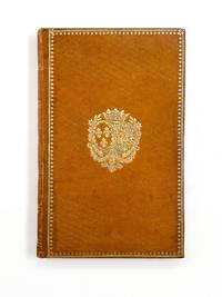
1816réf. 55305Paris: Vente 1816. Fine. Royal wedding edition of this popular pre-Revolution comedy issued on the occasion of the marriage of Princess Marie-Caroline and the Duc de Berry - and from the library of the Duchess herself who famously sold her books after her failed coup in 1832. The Duchess's wedding occurred only a year after the restoration of the royal House of Bourbon in 1815 following Napoleon's final defeat at Waterloo. On that occasion a special performance of Andrieux's 1787 play was performed for the Duchess a devotee of the theater. This rare edition was printed as a memento of that event which was to have massive implications in French history. The Duchess's new husband was the king's brother; after the Duc de Berry's assassination in 1820 their son became the heir apparent to the French throne. But when the July Revolution of 1830 deposed the Bourbons the Duchess and her son went into exile. In 1832 however the Duchess of Berry clandestinely returned to France to lead a rebellion becoming "the most wanted woman in France" Samuels. Her coup failed and she was once again exiled; her story would later be dramatized in fiction by Alexandre Dumas as LES LOUVES DE MACHECOUL 1859. Realizing she would never return to her beloved library of some 8000 volumes at Chateau Rosny she made the decision to sell it. It was then one of the most famous libraries in France with a tremendous range in philosophy history travel science law theology fiction and theater. This copy's binding and bookplates mark its provenance from the library of the Duchess. It was bound by René Simier 1772-1843 who "had no superior and few rivals during his career" Ramsden 190 with his ticket announcing him as "Binder to the King to Her Royal Highness the Duchess of Berry and to His Royal Highness the Duke of Bordeaux." The binding is in the style the Duchess regularly ordered from Simier featuring her gilt arms on the boards upon a carefully selected full morocco. It further bears the engraved bookplate of Rosny on the unusual pink endpapers. Books from the Duchess's library still appear with some regularity on the market today but rarely with such a close personal connection to the Duchess herself. Contemporary full honey morocco boards tooled in gilt with the arms of the Duchess of Berry bound by René Simier with his ticket "Relieur du Roi de S.A.R. Madame Duchesse de Berry et de S.A.R. Mgr le duc de Bordeaux". Pink glazed endpapers all edges gilt. 4 82 pages. Engraved bookplate of the Bibliothèque de Rosny on front pastedown; bookplates also of Alexis Rouart and Eugène Aubry-Vitet. Only trace rubbing and soil. Vente unknown
réf. 155015Lucerne: C. J. Bucher Ltd 1972. Remarkable and strangely moving First and sole edition one of 300 copies only privately printed. This example preserves the scarce brown wrapper with the printed word "Tenage" along one edge. "One intriguing photobook from the early 1970s was made by an elderly US diplomat stationed in Zurich named Byron Y. Berry. Photographed on the streets of various cosmopolitan cities Teenage Styles and Trends 1967-1971: A Retrospect 1972 is a series of street portraits of 'young lads' as Berry called them focusing in particular on the youths' long hair. The book is a recalling of the aged photographer's own lost youth a frank appreciation of beauty and a valuable photo-document of 1960s' street culture. At the time he made this remarkable and strangely moving book. Burton Y. Berry was in his sixties. The book moves us because it is so intimately connected with photography and time - youth and age. First and foremost this is a celebration of beauty. a unique snapshot of an era when it was especially exciting to be young. The subtle but unmistakable erotic undertones however add a personal level that is both beguiling and mysterious. the book is to be valued not only for its contribution to the gay photobook but to the literature of youth fashion and street culture" Parr & Badger. Quarto. 63 full-page black and white photographic illustrations. Original illustrated black and white boards lettered in white to front cover. Housed in a black cloth clamshell box spine lettered in gilt by the Chelsea Bindery. Top edge knocked; wrapper creased and roughly opened: a very good copy. Parr & Badger III pp. 77 and 80. hardcover
1816réf. 832071816. First Edition. DE BERRY Duchesse DE RANCÉ M. and THÉAULON Marie. LAnniversaire ou une journée de Philippe-Auguste. Paris: Cussac 1816. Slim octavo contemporary full straight-grain red morocco gilt gilt armorial coat of arms of La Duchesse du Berry on both boards elaborately gilt-decorated spine silk endpapers all edges gilt. $5500.First edition of the popular French play LAnniversaire from the library of La Duchesse de Berry with her gilt armorial coat of arms on both boards.This first edition of the French dramatic comedy LAnniversaire is from the library of Marie-Caroline de Bourbon-Sicile La Duchesse de Berry daughter of Francis I of the Two Sicilies and it contains her gilt coat of arms on both boards Olivier 2554. La Duchesse de Berry is well remembered for staging a brief rebellion against King Louis-Philippe in a vain attempt to gain the crown for her son Henri Dieudonné comte de Chambord. Her husband the Duc de Berry a son of Charles X of France had been assassinated in 1820. When Charles was overthrown in 1830 she tried to secure the succession for her son but was forced into exile. In 1832 disguised as a peasant she crossed the French border from Italy and made her way to the Vendée where she succeeded in instigating a brief but abortive insurrection June 1832. She was arrested in Nantes but was freed in July 1833 with the discovery of her recent marriage to an obscure Italian nobleman Count Ettore Lucchesi-Palli an act that exempted her from the French throne. She lived in Austria and Italy until her death Encyclopaedia Britannica. This one-act play in verse by dramatists de Rancé and Théaulon premiered at Théâtre-Français on November 16 1816. Text in French. Quérard 450. With gilt morocco bookplate of bibliophile Pierre Guerquin a director of Musées Nationaux de France. Bookplate of collector N.A.C. Embiricos. Tiny bit of marginalia to blank verso of front free endpaper.A fine copy with an impressive provenance. hardcover
1785réf. (LCPCALM-0001)(L' exemplaire de Louise-Marie-Thérèse d'Artois, fille de la Duchesse de Berry dans sa reliure en maroquin rouge du temps à ses armes) "ALMANACH ROYAL, ANNEE M.DCC.LXXXV...". 1785, Paris, D'Houry. 1 vol. in-8° (204x130 mm) (dimensions pages 198x120 mm) 684 pp. Reliure de l'époque en maroquin vieux rouge ornée d'une magnifique plaque de Dubuisson. Armoiries en losange au centre des plats. Dos à cinq nerfs avec fleurs de lys et titre dorés. Coupes ornées et tranches dorées. Gardes de tabis bleu. Rares et infimes rousseurs. Très bel exemplaire. Spectaculaire reliure ornée d'une plaque de Dubuisson: elle est décrite sous le n° 184k du Catalogue Rahir (Livres dans de riches reliures, Paris, 1910) et sous le n° 10 du Classement de Christian Galantaris. Provenance: Exemplaire aux armes dorées de la Princesse Louise-Marie-Thérèse d'Artois (1819-1864), fille du Duc et de la Duchesse de Berry. Ex libris armorié Bibliothèque du Château de Rosamel. (LCPCALM-0001) (4.500,00 €) (Tous les livres provenant d'Italie possèdent la licence d'exportation (Attestato di Libera Circolazione) du Ministero dei Beni e Attività Culturali)
Faksimile in 980 numerierten Exemplaren. Das "Kleine Stundenbuch" ein großes Kunstwerk. Die bedeutendsten Buchmaler des ausgehenden 14. Jahrhunderts haben im Auftrag des Herzogs von Berry ein Kunstwerk geschaffen, das wegen der Reichhaltigkeit und Feinheit der Malerei als eines der großartigsten Zeugnisse spätmittelalterlicher Kunst bewertet wird. Der Herzog von Berry war der größte Kunstsammler und Mäzen seiner Zeit. Neuwertiges Exemplar.
réf. 38945In-folio (323 x 214 mm), veau moucheté, dos à cinq nerfs orné de compartiments fleuronnés et cloisonnés et dune palette en pied, pièce de titre de maroquin rouge, plats encadrés de triples filets, tranches rouges (reliure du XVIIIe), (4), ccvii (i.e. 197) feuillets, (1) f. à la marque de Galliot du Pré, deux gravures sur bois, lettrines, manicules. Angers, Charles de Boingne et Clement Alexandre, Janvier 1529 [i.e 1530].
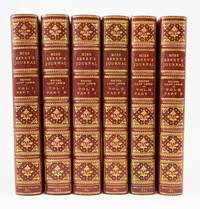
1865réf. ST19156London: Longmans Green and Co 1865. FIRST EDITION. 222 x 146 mm. 8 3/4 x 5 3/4". Three volumes extended to six. Edited by Lady Theresa Lewis. EXCEPTIONALLY PRETTY CRIMSON CRUSHED MOROCCO HANDSOMELY GILT BY MORRELL signed on front inner dentelles covers bordered with double rules raised bands spines gilt in compartments featuring drawer pull and cinquefoil cornerpieces and elegant floral centerpiece elaborately gilt inner dentelles top edge gilt other edges rough trimmed. EXTRA-ILLUSTRATED WITH MORE THAN 275 ENGRAVED PLATES 30 of them views the rest portraits four of the plates folding and eight in color. One plate with small skillfully repaired tear at fore edge a few leaves and a dozen plates with sprinkled foxing isolated light offsetting and minor stains and soiling in the text but AN EXTREMELY FINE SET THE LOVELY BINDINGS UNUSUALLY BRIGHT AND VIRTUALLY UNWORN and internally very fresh and clean. This lavishly illustrated and handsomely bound set documents the very long and meaningful life of a spinster devoted to her father and her sister—and to literature. Mary Berry 1763-1852 grew up in a family of modest fortune yet she knew a great many important people including Princess Caroline of Wales the estranged wife of the Regent their daughter Princess Charlotte and the author Mme. de Stael who described Mary as "by far the cleverest woman in England." Mary met Lord Byron and Napoleon but her greatest friend was Horace Walpole the society wit letter-writer and builder of the neo-gothic extravaganza Strawberry Hill. Walpole who met Berry and her younger sister Agnes when they were in their twenties became so fascinated by their wit and wisdom that he persuaded them to settle with their father near him at "Little Strawberry Hill" which he bequeathed to them in his will. He left them his manuscripts as well and Mary Berry became the editor of his works. She also authored a play and a study of English and French society but our collection of her journal entries and letters put together by Lady Theresa Lewis 1803-65 is Mary Berry's most enduring legacy. The journal begins when Mary at 20 sets out with her father and Agnes for a tour of Holland Switzerland and Italy where she looks at paintings attends plays and records the ups and downs of stagecoach travel. The letters and entries in her journal written until her death give a rare picture of her times and her clever and endearing personality. At the same time some entries are melancholic in which she attributes falling short of achievements commensurate with the level of her abilities and never experiencing marriage and motherhood. Besides charming portraits of the Berry sisters the illustrations in our expanded set depict the authors they read Dryden for example the painters whose works they viewed the many notable figures they met or gossiped about royalty politicians actresses people of fashion and views of the places they visited. Our lovely set was produced by the London bindery of W. T. Morrell established about 1861 as successor to the firm begun by Francis Bedford who in turn had taken over the famous bindery of Charles Lewis. Prideaux in her "Modern Bookbindings" published in 1906 says that Morrell at that time had a very large business that supplied "all the booksellers with bindings designed by his men" bindings that were "remarkable for their variety and merit." The six volumes here look remarkably attractive on the shelf. Longmans, Green, and Co unknown
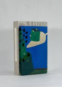
réf. 9573Monterey KY: Larkspur Press 2006. Full Leather. Fine binding. Octavo. 4 36 4 pp. Limited edition number 9 of 75 copies on Somerset Book paper there was also an edition of 500 regular copies. Signed by Wendell Berry at the colophon; additionally noted by Fox the year it was bound. In full goatskin binding with a series of leather onlays tooled in gold and blind all creating a fantastic pictorial binding. Accompanying the binding is a fine paper portfolio with publisher's prospectuses samples and associated material; additionally some templates related to Fox's binding. All housed a custom clamshell by Fox. The text offers a lens into the 19th century view of how a native of region assesses the value of the natural wonders. Berry's commentary at the end of Allen's text brings the troubling viewpoint into a modern context: "The chapter is built upon a division of mind which in our time has become terrifying but which Allen believed to be no more than a simple equation. On the one hand in a sentimentally romantic fashion he was sensitive to the natural life of the area which was then still intact. And on the other hand he seems eager for the destruction of this virgin bounty that so inspired him. I say 'the destruction' and not 'the use' for his language is patently that of an exploiter intent upon 'conquering' nature." A sobering volume that will most surely always remain relevant. Larkspur Press unknown
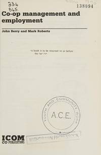
1984réf. SBBI-L-BE600350-RAG-20250ICOM Co-Publications 1984. paperback. Good. Our good condition books are generally good for reading but not for gifting or collecting. They could have imperfections such as creasing fanning inscriptions margin notes yellowing staining on edge or cover or pages bumps scuffs etc etc sometimes multiple of these. It's a wide category that encompasses anything that isn't almost-new down to anything that is slightly better than poor. We would NOT recommend gifting Good books - these should be considered reading copies. Our books are dispatched from a Yorkshire former cotton mill. We list via barcode/ISBN so please note that the images are stock images and may not be the exact copy you receive furthermore the details about edition and year might not be accurate as many publishers reuse the same ISBN for multiple editions and as we simply scan a barcode or enter an ISBN we do not check the validity of the edition data when listing. If you're looking for an exact edition please don't order at least not without checking with us first although we don't always have time to check. We aim to dispatch prompty the service used will depend on order value and book size. We can ship to most countries see our shipping policies. Payment is via Abe only. ICOM Co-Publications paperback
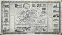
réf. 11193Manchester: 1741-c.46. No binding. Fair. THE FIRST PLAN OF MANCHESTER. 695 x 1230 mm. in two sheets joined with some support repairs to the verso but no apparent loss edges re-margined just affecting ornamental border below otherwise in good condition. This is the first known plan of the cities of Manchester and Salford. It is an extremely ornate plan complete with inset views of significant buildings and a fine panorama of the city below. It illustrates the cities as the population was growing rapidly but still arguably before the industrial revolution was to re-write its character. It was printed in 1741 by Russel Casson and John Berry. Casson fl.1741-47 is listed in Eden as a surveyor. John Berry d.1765 as identified was a merchant grocer at the New Tea Warehouse Manchester. His advert on the plan identifies the many wares he sold which include buttons jewellery silver medicines cough drops music and musical instruments including 'fiddle strings'. The two cities were divided during the English Civil War with Salford supporting the Royalist cause and Manchester the Parliamentarians. Similarly Salford was host for another important period of English history. In 1745 just four years after this was published the city supported Bonnie Prince Charlie's claim to the English throne and hosted him and his army where he was blessed by Reverend John Clayton before marching to London. He was housed by John Dickenson at 44 market Street whose house is illustrated upper right. As a result the house was nicknamed 'The Palace'. Just nine days later Bonnie Prince Charlie returned defeated. The main plan is orientated with north to the lower left. Deansgate runs top right to the centre of the city. Kay Street is most likely Quay Street. Other points of reference above Deansgate include King Street 'St. Jame Square' and M Street Market Street. Shude Hill on the left marks the site of the Arndale Centre today. At the bottom is Gravel Lane which still exists just south of present-day Trinity Way. An inset lower right illustrates the area as it was in 1650 the source has since been lost. The plan is keyed by upper- and lower-case letters which refer to two side reference panels identifying 118 points of interest along with an additional 9 below the advertisement. Below is a superb panoramic view at bottom derived from that by Robert Whitworth first published in 1729 by Henry Overton and John Hoole. Above the two reference panels are two further describing the cities of Manchester and Salford. They highlight the growth in population and that the area now has about 6000 houses and 30000 inhabitants. It goes on to state that the three main trades are Cotton manufacturing the check trade and small wares which include lace tapes etc. One unpleasant reference states that 'Children even of 4 or 6 years old who by spinning winding or weaving may earn more here than in any other part of ye Kingdom'. Flanking either side are 6 images of key buildings including the residences of Mr. Floyd Mr. Marsden Mr. Croxton Francis Reynolds Mess. Clowes and Mr. Marriott. These are supplemented with those of Mr. Howarth Mr. touchet Mr. Dickenson Mr. Johnson and Miles Bower above the main plan. Here also is found a view of St. Anns Square. The whole is surrounded by a side border of oak leaves and acorns with shells in the corners. A scale is placed in the lower border. The engraving is the work of Benjamin Cole 1697-1783 who signs it lower right one of four of that name identified by Worms and Baynton-Williams who state that they are most likely related. His earliest recorded work is a magnificent four-sheet plan of Richmond in Yorkshire for Robert Harman published in 1724 of which just three examples are known. He died in London in 1783. There are believed to be five known states the first being published and dated 1741 which lacks the panorama below. This third state includes the panorama and adds a small compa 1741-[c.46] unknown
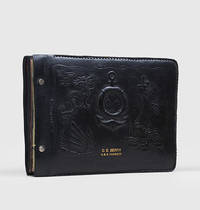
1934réf. 115861Chefoo Yantai Shanghai Singapore: 1934-37. Battleships baseball and the Bund An evocative album containing over 300 photographs both personal and from commercial studios recording the active service of the USS Parrott DD-218 on the China Station with the Asiatic Fleet - part of Destroyer Division 58 - including the Asiatic neutrality patrol in 1935 and 1936 offering a wealth of images of China Japan the Philippines and the South Pacific on the eve of the Second Sino-Japanese War 7 July 1937-9 September 1945 and the Second World War. Studio photographs include a number from the renowned commercial photographers Afong based in Yantai formerly Chefoo Joseffa and Skvirsky both established in Shanghai. It was compiled by Yeoman 2nd Class E-5 Charles Edmond Berry and opens with two fine photographs of the officers and crew of the Parrott on deck two colour-tinted photographs showing the ship at anchor and a humorous pictorial advertising photo from the Afong studio including an image of the studio exterior - clearly issued to all ships passing through Yantai - and featuring the Parrott at the centre. There follows an often joyful evocation of life onboard a US Navy destroyer prior to the Second World War with photos of the after-parties at the famed Beach Cafe in Chefoo which featured White Russian "hostesses" and tremendous amounts of alcohol as well as the morning-after breakfasts. Berry has also included panoramic photos of the Asiatic fleet in harbour at Chefoo Yantai and Hong Kong even including a humorous photographic pictorial "Bootlegger's Map of the United States." There are a series of photos showing the other US Navy Clemson-class destroyers on station with the Parrott the USS Pillsbury USS Bulmer USS John D. Ford USS Paul Jones USS Smith Thompson and USS Pope as well as various shipboard shenanigans baseball games battleships and destroyers on maneuvers gunnery practice loading of shells crew pets Liberty parties sailors carousing down the Bund in Shanghai buying souvenirs in Cuba sailing through the Panama Canal sightseeing trips to a walled city in Northern China the Great Wall of China cremation ceremonies in Bali riding rickshaws snake charmers and more. There are photos of Pan American Airways flying boats landing and unloading passengers in China many street scenes in Shanghai Hong Kong Tsing Tao Qingdao including the beheading of Chinese robbers outside the town Peking and Singapore. Of special interest are the series of photos showing Chinese Naval Ships from the Republic of China Navy in the mid-1930s including the CNS Yixian sunk by Japanese aircraft in September 1937; CNS Yisheng which had been converted into a gunboat in 1928 later sunk the CNS Shin Shey built in 1911 converted to a gunboat in 1929 sunk in 1938 and many others. There are also images of Kobe Yokohama street cars in Shanghai parks in Tokyo street scenes in Kyoto and views of the temples there. The USS Parrott DD-218 was a Clemson-class destroyer laid down by William Cramp & Sons Philadelphia and launched in 1919 commissioned in 1920 with a complement of 157 officers and enlisted men. The Parrott spent most of her career sailing with the Asiatic Fleet was awarded the Yangztze Service Medal in part for humanitarian assistance during the flooding of 1931-32 operating through the Chinese Civil War which resulted in considerable naval activity in Chinese waters collecting hydrographic data in and around Saigon then French Indochina in 1935. By 1940 she had served successively as station ship at Amoy Xiamen and Swatow Shantou China. From 7 July to 4 October she patrolled China waters based at Tsing Tao Qingdao and then made calls to other northern Chinese ports returning to Manila on 11 October. There in the early months of 1941 she was refitted with anti-mine and detection gear for anti-submarine warfare. The Parrott saw action in several theatres of war: South China Sea Battle of the Java Sea Atlantic Convoys and the bombardment of Spanish Morocco. She was accidentally rammed by the SS John Morton in Norfolk Naval Shipyard in 1944 and so severely damaged that she was decommissioned that same year and saw no further active service. Thick oblong quarto 380 x 280 x 51 mm. 319 corner-mounted original photographs ranging in size from 102 x 63 mm to 292 x 240 mm including 6 colour-tinted images and 4 panoramas 292 x 145 mm many studio prints captioned in the negative often with the photographer's stamp at lower corner a few with manuscript annotations verso coloured and patterned tissue guards intact white pink blue and jade-green. Contemporary heavily embossed black padded-calf post-binder photo album front board with devices of a Chinese Dragon a junk the Great Wall a life-preserver and anchor title in gilt as above nickel-plate posts rounded corners 52 leaves of black heavy card-stock most of the original tissue guards preserved. Together with a very appealing group of related ephemera and publications including: The Missions to Seamen The Sailors' Institute Anson Road Singapore; The Short Cut to Beauty: Hong Kong's Peak Tram; jocular Subpoena and Summons Extraordinary Royal High Court of the Raging Main Domain of Neptunus Rex two copies; U.S. Naval Despatch USS Parrott; Voyage Smoker USS Henderson en route to Honolulu T.H. to Guam M.I.; Radio Press News en route Manila P.I. to Guam M.I. 23 March 1937; Map of Shanghai dog tags and Bakelite Jesus medallion all preserved together in the original canvas sailcloth bag with stud fasteners. A few slight scuffs to binding occasional creasing to the mounting leaves very minor damage to a couple photographs overall in excellent condition. hardcover
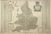
réf. 8243London: William Berry at the Sign of the Globe between Charing Cross and White Hall. 1680. No binding. Good. 590 x 880 mm. in two sheets joined early outline colour some professional repair to lower centrefold not affecting the image with one or two small surface marks none offensive trimmed just touching the upper left corner but generally with good margins all round otherwise in good condition. A fine rare English seventeenth century road map. In September 1678 Robert Morden fl. 1669 d. 1703 and William Berry 1639-1718 petitioned the crown for ""a licence to do all general and particular maps of the several parts of the world according to an alphabeticall manner"". Morden's connection with what appears to be the birth of the folio atlas is not heard of again. Berry began publishing a series of large two sheet maps with a group of the world and continents advertised in the 'London Gazette' from 1-5 July 1680. The world is also announced in the 'Term Catalogues' for the summer of that year. This only mentions the world map which would undoubtedly have been finished first and the continents would have followed. Berry did not advertise his next two sheet map that of England and Berry's first until February 1682. ""Through the 1680s Berry published nearly forty large maps of parts of the world sufficient to cover it all. From the late 1680s he clearly offered them bound together as a collection of maps as a handful of examples are known but this was clearly not the intention for the maps as none have borne any title page. Examples are known in the British Library the Library of Congress and the National Maritime Museum Greenwich all bearing either thirty-seven or thirty-eight maps. An example has been noted for sale by Maggs Brothers which bore sixty-nine maps the balance being made up of contemporary English maps by other cartographers dating the atlas to c.1704 and two further offered at Christies auctions in London in the 1980s"" Burden. This second map of England by Berry was announced in the 'Term Catalogues' for November 1685 and dedicated to James II who became King on 6 February 1685. He was deposed in the Glorious Revolution of 1688 by William III and for the second state offered here the dedication is altered to reflect the new King. The map is derived from the large wall map of the roads by John Adams published in 1677. It features the distances between towns within circles and by using straight lines. The inspiration for Adams' original work was undoubtedly the success of John Ogilby's book of roads entitled 'Britannia' published in 1675. Provenance: private English collection since the 1970s when it was acquired for £9! Burden 1996-2007 532; Phillips 1909- 3442; Shirley 1988 Berry 2.ii; Shirley 2004 T.Berr 1a no. 8; Tyacke 1973 p. 76; Tyacke 1978 no. 100 & pp. 109-10. William Berry at the Sign of the Globe between Charing Cross and White Hall. 1680 unknown
1831réf. 254561London 1831. Miniature globe in turned walnut case with domed lid. 1.5 inch diameter. 12 hand colored globe gores with original varnish and metal pins at each pole which enable the globe to spin in the case. Cartouche set in north Pacific. Stains along the equator in the Pacific. This terrestrial globe is the smallest version made by Newton and Berry Sumira p. 189. Wonderful detail included for such a small globe. The track of Captain Cook's final voyage of 1776 is shown when Captain Clarke and Gore sail to the Bering Sea after Cook is murdered. John Newton 1759-1844 is the founding member of this family firm. Miles Berry joined the firm in 1803. They also made planetaria and mechanical models. An excellent example of a pocket globe. unknown books
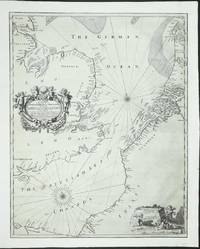
réf. 8773London: c.1672. No binding. Good. An UNRECORDED AND APPARENTLY UNIQUE EXAMPLE. 435 x 550 mm. a tear runs between Flanders and France there are two others above two more smaller tears are along the lower margin and one on the left side. Similarly a small thumbnail sized area has been filled in lower left of the title where there has been some loss at the fold. All tears have been professionally restored and the whole has been re-margined not backed and some of the engraved neatline is lacking on the right otherwise in good condition. An UNRECORDED AND APPARENTLY UNIQUE EXAMPLE of a sea chart of the English Channel and North Sea engraved by Francis Lamb. The address given in the imprint by William Berry was occupied by him in the period 1672-76. This chart was likely published at the time of the Third Anglo-Dutch War 1672-74. Morden and Berry had already published a map of the Seventeen Provinces of the Low Countries at the outbreak of hostilities. England declared war at the end of March 1672 and in the 'London Gazette' for 2-6 May were already advertising the map. It is highly likely that this chart was issued at a similar time. There is no mention retrospectively of any aspects of the war which might support an argument that says it was issued to illustrate the forthcoming conflict. ""Two of the most active publishers and mapsellers in London during the end of the seventeenth century were Robert Morden fl. 1669-d.1703 and William Berry 1639-1718. At the beginning of their careers it appears they worked in partnership. The 'Term Catalogues' detail publications together between 1673 and 1677. Most early records including those of the diarist Samuel Pepys refer to their activity in the production of globes. The last known evidence of a partnership was their petition to the crown in September 1678 for a licence to produce a folio atlas of the world in an 'alphabeticall manner'. This would become the sole production of Berry. Morden and Berry would both sell Richard Daniel's map of c.1679. Morden began with a shop shortly after the Great Fire of 1666. His reputation is underrated indeed Worms describes him as 'a prolific and inventive map maker whose critical reputation despite a string of innovations remains undeservedly low'."" Burden. The map is engraved by Francis Lamb fl.1667-1701. It extends from Normandy and Southampton to Texel and York and is centred on the Straits of Dover. An extensive search has revealed that this appears to be the only known example. Further research also identifies that the plate was purchased soon after by John Seller and is found included three known atlases. These are the 'Atlas Maritimus' owned by the Earl of Essex and those at Yale CBA Atlas Folio A; BL Maps 1066.6. When Seller entered financial difficulties and went into a partnership otherwise referred to as the Combine in 1677 a third state was issued. Examples of the map in this state have been located in three further atlases; Library of Congress 'Atlas Maritimus' Phillips 4150; BL untitled atlas Maps C.27.d.17 M.Sell 4a no. 53; NMM Thornton 'Atlas Maritimus' Sanderson 449 no. 10. A reduction of this map was also published by Morden and Berry at a similar date using the same addresses. Provenance: Clive A. Burden Ltd; private English collection. Burden 2007 431; Tyacke 1978 no. 11; Worms & Baynton-Williams 2011. c.1672 unknown
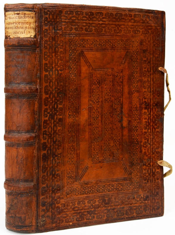
1575réf. 15133Francofurti, Ex officina Typographica Nicolai Bassei, 1575. 3 parties en 1 vol. in-folio (210 x 320 mm) à 2 colonnes par page de (6) pp. 1 f. bl. 137-(23) pp. (8)-145-(13) pp. 245-(18) pp., index pour chaque partie, basane fauve, dos à quatre nerfs, pièce de titre manuscrite, décor de filets droits, de frises et de roulettes, estampé à froid sur les plats, lacets (reliure de l'époque).
Faksimile in 980 numerierten Exemplaren. Die Bilderhandschrift "Tres Belles Heures" markiert einen Höhepunkt mittelalterlicher Buchmalerei. Das Werk wurde geschaffen zu Beginn des 15. Jahrhunderts von den begnadetsten Künstlern jener Zeit. Die berühmten Gebrüder Limburg gestalteten die beiden letzten Seiten der Handschrift. Verschwenderisch in Gold und Farben wurden die einzelnen Miniaturen ausgemalt. Neuwertiges Exemplar.
1968réf. 59947London, Macmillan, 1968. Large8vo. In contemporary full green cloth with gilt lettering to spine. In ""Nature"", vol. 220, 1968. Entire vol. 220, October - December offered. Small white paper label pasted on to lower part of spine. Stamps to fore edges. Pasted down- and free end-papers with stamps and paper labels from Gettysburg College Library. ""Withdrawn""-stamps to pasted down front end-paper and front free end-paper. P. 650. [Entire volume: (2), 1366, III- XXVIII pp.].