1 330 résultats
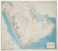
réf. 56801Washington D.C.: Department of the Interior United States Geological Survey and the Kingdom of Saudi Arabia Ministry of Finance 1963. Second edition English issue. Large chromolithohraphed map 122 x 139 cm of the Arabian peninsula shown with topographic relief and marked with water pipelines oases oil fields oil pipelines ports and harbours oil wells natural gas fields quarries and mines. Key lower left. The map includes the territories of modern day Kuwait Qatar Bahrain United Arab Emirates Oman and Yemen and was the work of a team lead by the distinguished geologist Glen F. Brown whose pioneering work on surface geology with its emphasis on water resources minerals and oil pertains to this day. Minor light spotting lower right generally in excellent condition. Issued simultaneously in an English and Arabic versions. Originally conceived in 1953 this second edition shows significant additional topographical detail and noticeably showing the growth in oil fields and accompanying infrastructure. Brown 1911-2001 began his career conducting coal investigations in South China and the Philippines and ground water investigations in Mississippi and Colorado the latter mostly concerned with supplying water to military installations. In response to a request from Ibn Sa'ud for assistance from the United States Geological Survey USGS Brown was selected in 1944 to investigate water supplies in the Saudi Arabian desert. Brown "arrived in Saudi Arabia early in 1945 and joined a mission sponsored by the US Foreign Economic Administration to study possibilities for agricultural development in central Arabia. As part of the mission he carried out a detailed investigation of the geologic formations in the Al Kharj district and identified substantial ground-water resources in buried aquifers. His report on the results of that investigation was very enthusiastically received by Saudi officials. Brown returned to Saudi Arabia at the request of Ibn Saud to conduct reconnaissance geologic mapping mineral evaluation and water-resource studies in the western and central parts of the kingdom. The mapping was carried forward from 1950 to 1958 by Brown with USGS and Saudi associates and extended to the entire Arabian Peninsula in cooperation with the Arabian American Oil Company Aramco as well as to organizations and companies of other countries in the peninsula. This resulted in a remarkable series of bilingual geologic and geographic maps of Saudi Arabia at a scale of 1:500000 and a geologic and geographic map of the entire Arabian Peninsula at a scale of 1:2000000 all of which were published by the USGS. These maps together with reports on the geology mineral deposits and water resources prepared by Brown and his associates providing the basis for Saudi Arabia to undertake a major national resource exploration and development program" obituary Geological Society of America. The map includes the territories of modern day Kuwait Qatar Bahrain United Arab Emirates Oman and Yemen. Although the hunt for oil gas and minerals ultimately drove geological survey work across the region in its early years it was the need for continual water sources which was the catalyst for Saudi Arabia's resource exploration. In 1944 King 'Abd al-'Aziz approached the United States for a technical expert who could assist with the identification and plotting of the kingdom's natural resources particularly its groundwater reserves. Glen F. Brown who undertook the task and is responsible for this map was one of the pioneers of a partnership between the United States Geological Survey USGS and the government of Saudi Arabia. This collaboration was one of international importance spanning the next five decades and influencing the development of the kingdom significantly. By 1954 the Saudi Ministry of Finance United States Geological Survey USGS and Aramco were working together to produce the first full series of geographic and geologic maps of the country. The first of their type in the Peninsula were published between the late 1950s and early 1960s in both Arabic and English copies. The information these maps contained formed the basis of subsequent Saudi national development plans. To this day all modern maps of the kingdom trace their roots back to these publications. Washington D.C.: Department of the Interior, United States Geological Survey and the Kingdom of Saudi Arabia Ministry of Finance unknown
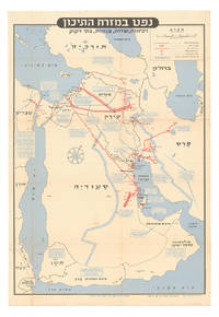
1957réf. ABC_46260Tel Aviv: Israel Defence Forces General Staff 1957. Folded. 56 x 82.5 cm. Chromolithographic map of the Arabian Peninsula from Turkey in the north to the Indian Ocean in the south and covering Saudi Arabia Egypt Israel Palestine Jordan Syria Lebanon Iraq Iran Kuwait Bahrain Qatar United Arab Emirates Oman North and South Yemen. Scale 1:5000000. Scale and key in Hebrew inset to top-right inset explanatory panels in Hebrew and English compass rose in Saudi Arabia. Extremely rare Israeli strategic map of the Arabian Peninsula showing oilfields and associated infrastructure. Printed in black red and blue the map demarks the political boundaries of the time along with the areas covered by oil companies concessions. Pipelines form a web across the northern part of the Arabian Peninsula shown in an uncommon vertical orientation while oilfields and refineries large and small are also marked. The IDF probably made the map in responce to the 1956 Suez Crisis and its associated geopolitical shifts. With the Egyptians operating the Suez Canal and the USA forcing Britain and France to abandon their post-imperial plans Israel now counted in both U.S. and Soviet plans for their control of Middle Eastern politics. Britain had to anchor its Middle Eastern influence in Cyprus Aden and Iraq while the increased American influence can be seen in the huge swathe of territory assigned to Aramco. We have located only one institutional copy of this map in the National library of Israel.With traces of pins from former wall mounting. A couple of small light stains some uneven creasing and tears at the edges of some folds and a couple tiny holes where the folds cross. Otherwise in good condition. Israel Defence Forces, General Staff, unknown
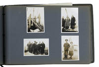
1931réf. ABC_46004Greece Palestine Iran Iraq Egypt 1931. Oblong photograph album 20.5 x 32 cm. With 72 sepia photographs ca. 6 x 8.5 cm. Album of personal photographs commemorating a journey in 1931-1932 to the oilfields in modern Iran and Iraq by a trio of travellers which included the Reverend Philip "Tubby" Clayton 1885-1972 the founder of the Toc H movement. Several photographs show Galilee Jerusalem Rutbah Wells Ar-Rutbah and about 10 show "fields" mostly the main oilfield at Masjed Soleyman and its gas separator.In 1931 Clayton was invited by the director of the Anglo-Persian Oil Company the predecessor of the British Petroleum Company "to inspect the work among the Company units in Persia and the Middle East generally" Harcourt. Accompanied by two friends he travelled by plane train and boat to Lake Tiberias and further by plane to Rutbah Wells a British airfield where the group spent Christmas Eve with British Dutch and German travellers. On Christmas Day they reached Abadan and from there visited the oilfields near Tehran Ahvaz Haftkel Mohammerah Basra and Masjed Soleyman. After a journey to Cairo and Alexandria they boarded an oil tanker for the return journey to Britain. This journey inspired Clayton to plead passionately for improvements to the life of the crews of oil tankers. He described "carrying oil by sea" as "the most lonely job on the world's waters" Clayton. In 1940 he became chaplain of Anglo-Saxon Petroleum's tanker fleet and would subsequently sail on multiple tankers.The photographs must have been taken by Henry Pegg Chappell 1909-1997 since the other members appear he is the only member not present in the photographs and he does not and only Clayton who completed the journey by oil tanker. A carbon copy of a typed list describing all photographs is inserted in the album. Since typed and handwritten additions to the carbon paper refer to Clayton in the third person he probably typed the original list and gave Chappell this carbon copy to insert in his album.With an inscription probably by the three travellers on the title page. Binding slightly worn at the extremities. Paperclip and staple on the typescript rusted. In very good condition.l Clayton "In a tanker" in: The Times 9 March 1932 p. 15; Harcourt The impudent dreamer pp. 216-219. unknown
réf. EN-130o.J. Öl auf Leinwand, um 1920, auf Keilrahmen, unsigniert. 50:40 cm.- Randdoubliert, mit restaurierter Fehlstelle im Bereich der Kopfbedeckung. Auf dem Keilrahmen bezeichnet ?Model Frau Tillmann? und ?Portrait Ruth?. Provenienz: Privatsammlung, Köln. Literatur: Ausstellungskatalog: August Sander und die Kunstszene der 20er Jahre im Rheinland, Köln, Josef-Haubrich-Kunsthalle und Kunsthalle zu Kiel, 2000, Kat. Nr. 283, Abb. 91, S. 85. - Abelen porträtierte Frau Tillmann mit ihrem von einer Lederkappe verdecktem Kurzhaarschnitt und Felljacke möglicherweise als Pilotin eines offenen Automobils, unbedingt aber als emanzipierte Frau der Weimarer Republik.
réf. EN-153o.J. Öl auf Karton, auf Blendrahmen aufgezogen, links unten monogrammiert und datiert ?E·D·K 13·?. 48,5:58,5 cm. - Provenienz: Aus dem künstlerischen Nachlass. - Seltenes Frühwerk Kinzingers, das in der Zeit entstand, als er Meisterschüler von Adolf Hölzel war.