2.528 resultados
1941ref. 2111902160500063Not Available 1941. Soft Cover. Fine. Number of pages: B5 each volume 80 pages Average size: There is a hole for the postmark Not Available paperback
1895ref. 178376Japan.: 星野嘉吉. Hoshino Kakichi. Meiji 28 1895. Black and white illustrations foldout illustration 20 x 14cm 8pp unpaginated. Slight fold crease at the centre else a lovely clean and tight copy. This advertisement catalogue of Japanese fire pumps was published in 1895 with delicately fine illustrations. The pumps are manufactured by Hoshino Kakichi Factory in Aizu-Wakamatsu in Fukushima prefecture. The catalogue shows a black and white illustration of the factory compound as well as 6 types of fire pumps. Each pump is illustrated with its specification information including how far water spray can reach. 3 of them have 2 wheels and the rest with 4 wheels. In its foreword the owner claims that it is necessary to have a fire pump at hand as houses in the area are venerable for fire due to their thatched roofs. In addition he claims that locally manufactured pumps are cheaper to purchase and their maintenance is readily carried out close-by. . 星野嘉吉. [Hoshino, Kakichi]. unknown
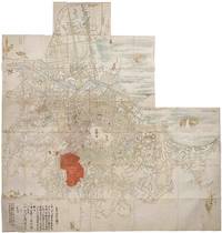
ref. 215931Japan. Very large hand coloured folding map 200 x 189.5cm at the largest section six panels have been removed from one corner while another two and a half panels have been included along one edge to show the reach of the city. Some insect damage repaired with washi but overall in very good condition. An exceptionally beautiful and detailed rare map of Tokyo in the Edo period the latter half of the 17th century. This remarkable delicately executed map of Edo around the 1660s offers a wealth of detailed information about the city and its population during the early Edo period. Hundreds of names of landholders are neatly recorded. Family crests or mons are shown across Edo indicating locations of daimyo's or feudal lord mansions temples depicted with even ferry routes named! Edo Castle takes centre stage with the Sumida River flowing from north to south and emptying into the bay. Here several boats are delicately illustrated in colour some carrying images of lucky gods. Prominently displayed in red is the mansion of Sakai Shurinosuke namely Sakai Tadanao 1630-1682 who received the rank of Shuri-Taiyfu 修理大夫 from the Emperor. He was a daimyo from the domain of Obama Fukui Prefecture and successor to his prominent father Sakai Tadakatsu 1587-1662. Tadakatsu served as one of the most trusted ministers of Tokugawa Iemitsu 1604-1651 the third shogun. His son Tadanao was active as a daimyo between 1656 and 1677. A handwritten section at the top right details the Sakai family's fire responsibility area. The borders are defined by street names and landmarks and distances are listed from the main mansion and residence to Ushigome-mon one of Edo Castle's gates. In summary the area of responsibility is approximately 10 cho 1 kilometre east to west and 12 cho 1.2 kilometres north to south. Though not explicitly dated beyond the mention of "November" the map was probably created in the 1660s. The Meireki Fire 1657 caused a large scale devastation around the castle and the Tokugawa government heightened the need of fire fighting activities in the capital. The government firstly allocated responsible areas for each daimyo to carry out fire fighting and secondly started to produce large maps of Edo based on actual measurement. Consequently this map was most probably produced around the 1660s. Furthermore the dating is supported by the presence of Ryogoku Bridge built in 1659 and the absence of Shin-Ohashi Bridge which wasn't constructed until 1693. Additionally the map provides detailed information on residents street names around the castle and other areas with major temples and shrines highlighted in colour illustrations. This truly exceptional map leaves many questions unanswered. Indeed who gathered the vast amount of information to be found on the map What was the exact purpose behind its creation The more we examine this map the more we learn and the more questions we have. However it is very clear that this rare and beautiful manuscript map provides a depth of information about Edo in the 1660s rarely found making the map a vital key to the city at this period. A handsome map which calls for more research. We have not been able to find a similar map nor have we ever handled anything comparable. . unknown