|
COLLECTIF
Université De Metz - Travaux et Recherches 1973/2
Metz Maisonneuve 1973 In8 190 pages - broché - Au Sommaire : La campagne de Julien contre les Perses par JM Demarolle / le point de vue des chroniqueurs de la france du nord sur les allemands dans la 1ere moitié du 12e siècle par M.Schmidt / la politique étrangère de la france face a la guerre hispano-américaine par T.Lewis / l'administrations des territoires rhénans pendant la période de l'armistice par J.Bariety / les limites du nationalisme barésien : Barres et la rhenanie par JC Delbreil / la presse messine face a l'URSS -1939 par JC Mallinger / recherche sur l'attitude la SFIO a l'egard de l'unification européenne par P.Schaeffer - Trés bon etat
Bookseller reference : 95Ch
|
|
|
COLLECTIF Foch Barres Lavedan Madelin Hanotaux Baudrillart Goyau Bertrand
Jeanne d'arc
grand in8. Broch�. 136 pages. Horizons de france unknown
Bookseller reference : 123238

|
|
|
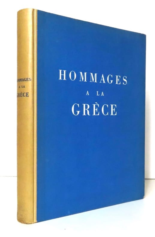
Collectif - Introduction de Vassily Photiadès. Textes de Renan, Thibaudet, Maurras, Barrès, Michelet, Lacretelle, Ramuz:
Hommages à la Grèce.
Lausanne, La Guilde du livre, 1942. Grand in-8, cartonnage bleu imprimé, dos ivoire. Cartonnage très légèrement défraichi, quelques petites taches sur tranches. Nom de possesseur sur garde. Illustré de 12 hors-textes photographiques en noir, contrecollés.
Bookseller reference : 20771
|
|
|
Collectif ; BARRES, Maurice ; GORKI, Maxi ;
Le Roman romanesque - Oeuvres des maîtres de la littérature contemporaine - Tome 11
1 vol. in-12 br., texte sur deux col., coll. Oeuvres des maîtres de la littérature contemporaine, Société d'édition et de publication, Paris, 1906, 512 pp. Contient notamment : Le Duel, moeurs militaires russes (A. Kouprine) ; La Haine emporte tout (de Maurice Barrès) ; Fille de Traître (Ernest Daudet) ; En Prison (Maxime Gorki) ; La Uhlane (Jean Richepin) ; etc.
Bookseller reference : 47543
|
|
|
COLLECTIF Dont Emile Nicolas - Maurice Toussaint - R.Harmand
Le Pays Lorrain - 26e Année - N.7 - Juillet 1934
Nancy société D'archéologie Lorraine et Du Musée Historique Lorrain 1934 In4 Environ 50 pages - nombreuses photographies - Au Sommaire : le mouvement artistique a Nancy / lettres de Maurice Barres à Camille Jullian - la bibliotheque d'un bourgeois lorrain au XIXe siècle - bon etat
Bookseller reference : LorRev17
|
|
|
COLLECTIF Dont Gabriel Richard - Georges Sadler - J.Bertaux - André Lefevre
Le Pays Lorrain - 38e Année - N.3 - 1957
Nancy société D'archéologie Lorraine et Du Musée Historique Lorrain 1957 In4 Environ 50 pages - nombreuses photographies - Au Sommaire : Les cent jours a Nancy / avec Barrès à Sion vaudemont / a propos du mariage du prince henri de France et de la duchesse Marie Therese de Wurtemberg / berlioz et les Vosges / bon etat
Bookseller reference : LorRev14
|
|
|
COLLECTIF Dont Pierre Marot - F.Vazemmes - Jacques Choux
Le Pays Lorrain - 54e Année - N.3 - 1973
Nancy société D'archéologie Lorraine et Du Musée Historique Lorrain 1973 In4 Environ 50 pages - nombreuses illustrations - Au Sommaire : Le cinquantenaire de la mort de Barrès / Les promenades de Maurice Barrès en bassigny , a propos de sa correspondance avec alcide Marot / deux pretres vosgiens , amis de Maurice Barrès / Valentin Bousch à saint Nicolas de Port et à Flavigny - bon etat
Bookseller reference : LorRev22
|
|
|
COLLECTIF, [Maurice BARRES]
REVUE DU TARN, mars 1962, N°25, troisième série
Revue du Tarn, Toulouse, 1962.
Bookseller reference : 1228
|
|
|
Collins Samuel Des Barres Antoine th cent Manley Roger Sir ? . Russian impostor. French.
Relation curieuse de l'estat present de la Russie 1679 Leather Bound
2019. Leather Bound. New. Leather Binding on Spine and Corners with Golden Leaf Printing on round Spine. Reprinted in 2019 with the help of original edition published long back 1679. This book is printed in black & white sewing binding for longer life Printed on high quality Paper re-sized as per Current standards professionally processed without changing its contents. As these are old books we processed each page manually and make them readable but in some cases some pages which are blur or missing or black spots. If it is multi volume set then it is only single volume if you wish to order a specific or all the volumes you may contact us. We expect that you will understand our compulsion in these books. We found this book important for the readers who want to know more about our old treasure so we brought it back to the shelves. Hope you will like it and give your comments and suggestions. Lang: - fre Pages 439. EXTRA 10 DAYS APART FROM THE NORMAL SHIPPING PERIOD WILL BE REQUIRED FOR LEATHER BOUND BOOKS. FOLIO EDITION IS ALSO AVAILABLE. hardcover
Bookseller reference : LB1111005104324
|
|
|
Collins Samuel Des Barres Antoine th cent Manley Roger Sir ? . Russian impostor. French.
Relation curieuse de l'estat present de la Russie 1679
2020. Paperback. New. Lang: - fre Pages 439. Reprinted in 2020 with the help of original edition published long back 1679. This book is Printed in black & white sewing binding for longer life with Matt laminated multi-Colour Soft Cover HARDCOVER EDITION IS ALSO AVAILABLE Printed on high quality Paper re-sized as per Current standards professionally processed without changing its contents. As these are old books we processed each page manually and make them readable but in some cases some pages which are blur or missing or black spots. If it is multi volume set then it is only single volume if you wish to order a specific or all the volumes you may contact us. We expect that you will understand our compulsion in these books. We found this book important for the readers who want to know more about our old treasure so we brought it back to the shelves. Any type of Customisation is possible with extra charges. Hope you will like it and give your comments and suggestions. paperback
Bookseller reference : PB1111005104324
|
|
|
Collins Samuel Des Barres Antoine th cent Manley Roger Sir ? . Russian impostor. French.
Relation curieuse de l'estat present de la Russie 1679 Hardcover
2020. Hardcover. New. Lang: - fre Pages 439. Reprinted in 2020 with the help of original edition published long back 1679. This book is Printed in black & white Hardcover sewing binding for longer life with Matt laminated multi-Colour Dust Cover Printed on high quality Paper re-sized as per Current standards professionally processed without changing its contents. As these are old books we processed each page manually and make them readable but in some cases some pages which are blur or missing or black spots. If it is multi volume set then it is only single volume if you wish to order a specific or all the volumes you may contact us. We expect that you will understand our compulsion in these books. We found this book important for the readers who want to know more about our old treasure so we brought it back to the shelves. Any type of Customisation is possible with extra charges. Hope you will like it and give your comments and suggestions. hardcover
Bookseller reference : 1111005104324
|
|
|
Collognat Barres Annie
Diderot : Supplment au Voyage de Bougainville - Texte intgral et guide de lecture
Pocket. Used - Like New. Book in almost Brand New condition. Pocket unknown
Bookseller reference : GRP104811638 ISBN : 2266129074 9782266129077

|
|
|
Collognat Barres Annie
Diderot : Supplment au Voyage de Bougainville - Texte intgral et guide de lecture
Pocket. Used - Very Good. Great condition for a used book! Minimal wear. Pocket unknown
Bookseller reference : GRP104927606 ISBN : 2266129074 9782266129077
|
|
|
COPPEE François - LEMAITRE Jules - BARRES Maurice - DUBOIS Marcel - JEANTET Félix - DAUSSET Louis - SYVETON Gabriel
Annales de la patrie française. Revue. Du N° 107 au N° 125.
Couverture souple. 19 revues brochées. 452 pages.
Bookseller reference : 26616
|
|
|
CORDIER Marcel
Les Demeures Ou Ils Vécurent - Tome 1
Sarreguemines Pierron 1981 In8 Oblong 147 pages - trés nombreuses photographies - cartonnage editeur bon etat
Bookseller reference : 67Ce
|
|
|
CORDIER Marcel
Les Demeures Ou Ils Vécurent - Tome 1
Sarreguemines Pierron 1981 In8 Oblong 147 pages - trés nombreuses photographies - cartonnage editeur bon etat
Bookseller reference : 67Ce
|
|
|
Coulon Marcel Temoignages
Temoignages 3e série...Jean-Henri Fabre; Jean Moreas; Maurice Barres; André Rouveyre; Ephraim Mikhael
Paris, Mercure de France,1913. - vol. in-16.broche, numeroté,service de presse,couvertures passees,
Bookseller reference : 18358
|
|
|
COUPE François, Jean Du CROISSANT
Viens BARRES, Cavalt’toi BARRES
Viens BARRES Le grand succès du jour crée au casino des Blancs-manteaux. Une grande caricature de BARRES, en couleurs.,chantée tous les soirs par QUASIMODO sur l’air de Viens Poupoule ! Texte sur 2 colonnes Suivi de Cavalt’toi BARRES par Jean du CROISSANT. Nouveau cri populaire du quatrième arrondissement. Texte sur 2 colonnes, une illustration pleine page. L’ensemble en 4 pages in 8. Léon HAGARD imprimeur éditeur 8 Rue du Croissant Paris, sans date (fin XIXème) peu courant
Bookseller reference : 9844

|
|
|
CROUVEZIER Gustave & BARRES Maurice
L'aviation pendant la guerre
Berger-Levrault, Paris & Nancy 1915, 14x22,5cm, relié.
Bookseller reference : 81107
|
|
|
Curie Eve Barres Philippe and De Roussy De Sales
They Speak for a Nation: Letters from France
Garden City New York: Doubleday Doran. Very Good in Good dust jacket. 1941. First Edition; First Printing. Hardcover. Tight square unmarked book in bright red cloth; darkened top edge; in rubbed dust jacket with two chips from lower front edge and other edgewear; mapped endpapers. Sarce hardcover edition in jacket. ; 238 pages . Doubleday, Doran hardcover
Bookseller reference : 39236
|
|
|
Curtius, Ernst Robert
Maurice Barrès und die geistigen Grundlagen des französischen Nationalismus. Erstausgabe.
Bonn: Friedrich Cohen 1921. VIII, 255, (1) Seiten. Zweifarbiger Titel. 8° (22,5 x 16 cm) Orig.-Broschur. [Softcover / Paperback].
Bookseller reference : 2137726

|
|
|
d'agriculture Societe; Claude Etienne Chaillou des Barres baro Creator; commerce science et arts du depa Creator;
Essai Historique Et Critique Sur La Législation Des Grains Jusqu'à Ce Jour Ou Mémoire Sur Cette Question Proposée Par La Société D'agriculture . Moyens De Prévenir Av French Edition
Nabu Press 2012-01-19. Paperback. Good. Nabu Press paperback
Bookseller reference : SONG1272584836 ISBN : 1272584836 9781272584832
|
|
|
D'ANNUNZIO, Gabriele ; GEFFROY, Gustave ; GOURMONT, Rémy de ; SCHWOB, Marcel ; MILLE, Pierre ; SAMAIN, Albert , TINAYRE, Marcelle ; LOUYS, Pierre ; MAETERLINCK, Maurice ; REGNIER, Henri de ; JAMMES, Francis ; GIDE, André ; GUERIN, Charles ; BARRES, Maurice ; ROSNY Aîné, J.-H. ; BOURGET, Paul
[ Lot de 20 titres en 21 volumes de la collection "Les Maîtres du Livre" ] Vies imaginaires ; Le Roi au Masque d'Or ; Le Chemin de Velours ; L'Apprentie ; Le Feu (2 Tomes - Complet) ; Au flanc du Vase ; Au Jardin de l'Infante ; Physiologie de l'Amour Moderne ; Les autres vies et les autres mondes ; Colette Baudoche ; Le coeur solitaire ; La porte étroite ; Le Deuil des Primevères ; Le Bon Plaisir ; Les Jeux rustiques et divins ; Le Sang des Races ; Le Trésor des Humbles ; Contes choisis ; La Maison du Péché ; Barnavaux
Exemplaires sur papier de Rives numérotés, 21 vol. petit in-8 br. sous couv. rempliée, collection Les Maîtres du Livre, George Crès et Cie : Vies imaginaires, 1921 ; Le Roi au Masque d'Or, 1917 ; Le Chemin de Velours, 1923 ; L'Apprentie, 1920 ; Le Feu (2 Tomes - Complet), 1919 ; Au flanc du Vase, 1919 ; Au Jardin de l'Infante, 1924 ; Physiologie de l'Amour Moderne, 1917 ; Les autres vies et les autres mondes, 1924 ; Colette Baudoche, 1918 ; Le coeur solitaire, 1922 ; La porte étroite, 1920 ; Le Deuil des Primevères, 1920 ; Le Bon Plaisir, 1918 ; Les Jeux rustiques et divins, 1925 ; Le Sang des Races, 1921 ; Le Trésor des Humbles, 1921 ; Contes choisis, 1919 ; La Maison du Péché, 1913 ; Barnavaux, 1921
Bookseller reference : 56747

|
|
|
DADA & BARRES Maurice
Affiche originale : ""Mise en accusation et jugement de M Maurice Barrès pa EDITION ORIGINALE
s.n. 1921. Fine. s.n. 13 mai 1921 Affiche : 32x24cm / Cadre : 45;5x375cm une affiche encadrée sous verre. - 43803 - FRENCH VERSION FOLLOWS Affiche originale dadaïste intitulée «Mise en accusation et jugement de M. Maurice Barrès par Dada» encadrée sous verre permettant d'en voir les deux faces. Au verso «Extrait de l'acte d'accusation» rédigé par André Breton suivi de la liste des contributeurs. Une annotation manuscrite «VI n°47» à l'angle gauche du verso. Une petite restauration à l'aide d'une bande de papier et sans atteinte au texte au verso. Pliures sinon document bien conservé au jaune éclatant. Affiche annonçant le procès pénal fictif de Maurice Barrès par les dadaïstes qui se déroula le vendredi 13 mai 1921 à la Salle des sociétés savantes 8 rue Danton à Paris. Cette manifestation marque une divergence importante entre d'une part les animateurs de la revue Littérature Breton Aragon Soupault. et d'autre part Tristan Tzara et ses amis. Poursuivi pour «crime contre la sûreté de l'esprit» Barrès fut condamné à la peine afflictive et infamante de vingt ans de travaux forcés par un jury composé de douze spectateurs. Ce procès a été retranscrit dans le numéro 20 de la revue Littérature. s.n. unknown
Bookseller reference : 68991

|
|
|
DARSY, Eugène - Maurice Barrès (préface)
Les Droits Historiques de la France sur la rive gauche du Rhin.
1919 Librairie de la Société du Recueil Sirey; Petite Bibliothèque de la Ligue des Patriotes. 1919. 1 vol in-122, broché. 209 pages. Une carte rempliée en fin de volume
Bookseller reference : 98575
|
|
|
DAUDET Alphonse & GUAITA Stanislas de & ROLLINAT Maurice & LECONTE DE LISLE Charles-Marie-René & BARRES Maurice & NADAR Paul
La jeune France - Quatrième année complète
La jeune France, Paris 1881, 17x26cm, 12 fascicules reliés en 1.
Bookseller reference : 82687
|
|
|
DAUDET Alphonse & LORRAIN Jean & ROLLINAT Maurice & LECONTE DE LISLE Charles-Marie-René & BARRES Maurice & VERMERSCH Eugène
La jeune France - Cinquième année complète
La jeune France, Paris 1882, 17x26cm, 12 fascicules reliés en 1.
Bookseller reference : 82709
|
|
|
DAVID (Hermine) - BARRES (Maurice).
Un Jardin sur l'Oronte. Orné de six pointes-sèches de Hermine David.
Paris, Redier, N.R.F., s.d. ( 1929); in-8 broché, couv. imprimée verte et noire. PREMIER TIRAGE des 6 belles pointes-sèches hors-texte de Hermine David.
Bookseller reference : 46400078
|
|
|
David Griol Barres David Griol Barres Editor Zoraida Callejas Carrion Editor Ramon Lopez Cozar Delgado Editor
Technologies for Inclusive Education: Beyond Traditional Integration Approaches Premier Reference Source
IGI Global 2012-11-30. 1. Hardcover. Good. IGI Global hardcover
Bookseller reference : SONG1466625309 ISBN : 1466625309 9781466625303
|
|
|
De Barres Pamela
TAKE ANOTHER LITTLE PIECE OF MY HEART
1992 . De Barres Pamela. TAKE ANOTHER LITTLE PIECE OF MY HEART. NY: William Morrow and Company c1992. First Edition. 304pp. index illus. b/w. 8vo. Fine copy in d/w $25.00 unknown
Bookseller reference : 49258
|
|
|
De Boisdeffre Pierre
Maurice Barres.
pp. 128, mm 175x115, bross., Classiquedu XX° siecle
|
|
|
De Feure, Berthon, Camille Mauclair, Paul Margueritte, Victor Margueritte, Maurice BarrËs, Verhaeren, Roger Marx, Ernest Raynaud, Puvis de Chavannes, Perrichon, Jean-Emile Laboureur, et al.
L'Image. Revue litteraire et artistique ornee de figures sur bois, n∫ 8. (with "Au Luxembourg", by Jean-Emile Laboureur)
A COMPLETE PROOF SET ON CHINESE PAPER, before all letters, of all of the relief prints executed for the July issue--the ninth of twelve published--of L'Image, a groundbreaking artistic and literary journal. Numerous wood-engravings and woodcuts including A FINE PROOF ON CHINE OF LABOUREUR'S "AU LUXEMBOURG" (Laboureur I, 572), his first important print. Laboureur was 19 when this issue came out, and its publication marked his being recognized as a consequential artist. This copy, exceptionally, includes A "FUME" (early proof) OF THE WOOD-ENGRAVING AFTER THOMAS LAWRENCE, SIGNED IN PENCIL BY BELTRAND AND JUSTIFIED "FumÈ n∫ 1". Folio. Printed wraps illustrated iwth art nouveau wood engravings after Berthon and De Feure. Stitching loose, else FINE AND BRIGHT. Ray 321 and 321A.
|
|
|
DELHORBE Cécile
L'affaire Dreyfus et les écrivains français
Neuchâtel et Paris , 1932 1 vol. gr. in-8 354 pp, broché Tres belle documentation soutenue comme une these , qui met en scene Zola devant l'affaire Dreyfus, lAnatole France, Barrès, Péguy et Proust Rare dans cet etat comme neuf non rogné , photos sur demande Ray
Bookseller reference : 4754
|
|
|
DERCHE Roland
Études De Textes Français
Paris Société D'édition D'enseignement Supérieur 1966 11x17,5 2 volumes: 1er vol 251 pages - couverture un peu fatiguée avec un pli marqué en 4ème page - nouvelle série V - 19ème siècle "des mémoires d'Outre tombe aux Contemplations" - 2ème vol 305 pages -nouvelle série VI -19ème siècle et début 20ème "de Baudelaire à Giraudoux"
Bookseller reference : 17Ab
|
|
|
DEROULEDE P., BARRES M., LOTI P., LOUYS P.
CHANTS DU SOLDAT, AU SERVICE DE L'ALLEMAGNE, LE ROMAN D'UN SPAHI, LES CHANSONS DE BILITIS
Modern-Bibliothèque - Arthème Fayard. Non daté. In-8. Relié demi-cuir. Bon état, Couv. convenable, Dos satisfaisant, Intérieur frais. Env. 130 + 125 + 126 + 93 pages. 4 ouvrages en un volume. Premiers plats illustrés en couleur des ouvrages brochés conservés. Dessins en noir et blanc en frontispices. Illustrés de nombreux dessins en noir et blanc dans et hors texte. Pièces de titre rouges sur le dos. Auteur, titre, hache et filets dorés sur le dos. Ex-libris illustré en noir et blanc (Maud Harley) collé au dos du 1er plat.. . . . Classification Dewey : 840.091-XX ème siècle
Bookseller reference : RO40119007

|
|
|
DES BARRES Joseph Frederick Wallet 1721 1824.
3 FINE VIEWS OF BOSTON FROM THE HARBOUR.
London: the British Admiralty 1773. inches. 3 engraved views of Boston Harbour by William Pierrie after Des Barres. Three exceptionally fine views from des Barres magnificent "Atlantic Neptune": A View of Boston from Dorchester Neck; Long Island open on the North Side of Nicks Mate Islands; Boston from Willis Creek. Des Barres's service to the British Crown began in about 1752 when he enrolled as a cadet at the Royal Military Academy at Woolwich near London. Founded in 1741 the Academy was established to teach all the branches of mathematics necessary for men who would serve in the Artillery or as Engineers. Des Barres had already received an extensive education in his native Switzerland where he had studied both applied and theoretical mathematics at the University of Basle. Upon the completion of his training he became one of the first officers to be commissioned in the newly formed Royal American Regiment. Thus it was that at the close of the French and Indian War Des Barres was sent to America by the British Admiralty to survey the coasts of the Maritime Provinces. These provinces so recently acquired from France had never been adequately mapped and Des Barres spent the next ten years constructing a series of charts of unparalleled accuracy and beauty. Ultimately the project was expanded to include the entire Atlantic and gulf coasts of North America and his findings were published in the monumental "Atlantic Neptune". Catalogued by Kate Hunter @ Arader Galleries. [London: the British Admiralty], 1773. unknown
Bookseller reference : 72edv4
|
|
|
DES BARRES Joseph Frederick Wallet 1721 1824.
3 FINE VIEWS AROUND BOSTON HARBOUR.
London: The British Admiralty 1773. Single sheet with three engraved views sheet size: 32 6/8 x 24 inches; plate 10 x 6 4/8 inches. 3 engraved views of Boston Harbour by William Pierrie after Des Barres. Three exceptionally fine views from des Barres magnificent "Atlantic Neptune": A Front View of the Lines taken from the advanced Post near Browns House; A View of the Harbour of Boston taken from Fort Hill; A View of the Country towards Dorchester taken from the advanced works on Boston Neck. Des Barres's service to the British Crown began in about 1752 when he enrolled as a cadet at the Royal Military Academy at Woolwich near London. Founded in 1741 the Academy was established to teach all the branches of mathematics necessary for men who would serve in the Artillery or as Engineers. Des Barres had already received an extensive education in his native Switzerland where he had studied both applied and theoretical mathematics at the University of Basle. Upon the completion of his training he became one of the first officers to be commissioned in the newly formed Royal American Regiment. Thus it was that at the close of the French and Indian War Des Barres was sent to America by the British Admiralty to survey the coasts of the Maritime Provinces. These provinces so recently acquired from France had never been adequately mapped and Des Barres spent the next ten years constructing a series of charts of unparalleled accuracy and beauty. Ultimately the project was expanded to include the entire Atlantic and gulf coasts of North America and his findings were published in the monumental "Atlantic Neptune". Catalogued by Kate Hunter @ Arader Galleries. [London: The British Admiralty,] 1773. unknown
Bookseller reference : 72edv3
|
|
|
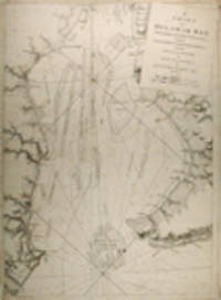
Des Barres Joseph F. Wallet
A CHART OF DELAWARE BAY WITH SOUNDINGS AND NAUTICAL OBSERVATIONS TAKEN BY CAPT. SIR ANDREW SNAPE HAMMOND OF THE NAVY AND OTHERS COMPOSED AND PUBLISHED FOR THE USE OF PILOTAGE.
London: Published by J. F. W. Des Barres in "The Atlantic Neptune" 1779. Black and white copper engraving. Plate size: 30 1/4 x 22 1/8 inches. Large repaired tear 12 inches from bottom edge parallel to centerfold. 4- inch repaired split from bottom in centerfold. Thin uneven margins. Else very good. This is a fantastic sea chart of the Delaware coast from THE ATLANTIC NEPTUNE which is universally recognized as one of the most magnificent atlases ever made. Constructed for the use of the British Navy this chart shows the major part of the Delaware coast from Rehobeth to Bombay Hook as well as the opposing south New Jersey shore. Des Barres of Swiss-Huguenot extraction studied under the great mathematician Daniel Bernoulli at the University of Basel before immigrating to Britain where he trained at the Royal Military College Woolwich. Upon the outbreak of hostilities with France in 1756 he joined the British Royal American Regiment as a military engineer. He came to the attention of General James Wolfe who appointed him to join his personal detail. During this period he also worked with legendary future explorer James Cook on a monumental chart of the St. Lawrence River. From 1762 Des Barres was enlisted to survey the coastlines of Nova Scotia Newfoundland and the Gulf of St. Lawrence while his colleague Samuel Holland charted the New England coast. He also managed to gain access to some surveys of the American South Cuba and Jamaica. In 1774 Des Barres returned to England where he began work on THE ATLANTIC NEPTUNE. His dedication to the project was so strong that often at his own expense he continually updated and added new charts and views up until 1784. That year he returned to Canada where he remained for a further forty years becoming a senior political figure and a wealthy land owner and living to the advanced age of 103. THE ATLANTIC NEPTUNE the most celebrated sea atlas contains the first systematic survey of the east coast of North America. Des Barres' synergy of great empirical accuracy with the peerless artistic virtue of his aquatint views created a work that "has been described as the most splendid collection of charts plates and views ever published" NATIONAL MARITIME MUSEUM CATALOGUE. Upon the conclusion of the Seven Years' War Britain's empire in North America was greatly expanded and this required the creation of a master atlas featuring new and accurate sea charts for use by the Royal Navy. Des Barres was charged with this Herculean task publishing the first volume in London in 1775 which was soon followed by three further volumes. Des Barres' monumental endeavor eventually featured over 200 charts and views many being found in several states. His charts were immensely detailed featuring both hydrographical and topographical information and in many cases remained the most authoritative maps of the regions covered for several decades. SNYDER CITY OF INDEPENDENCE p.271. Published by J. F. W. Des Barres in "The Atlantic Neptune," unknown
Bookseller reference : WRCAM39578

|
|
|
Des Barres JFW. publisher: Holland Samuel and George Callendar surveyors J. F.
A CHART OF THE HARBOUR OF BOSTON COMPOSED FROM DIFFERENT SURVEYS; BUT PRINCIPALLY FROM THAT TAKEN IN 1769 BY MR. GEORGE CALLENDAR LATE MASTER OF HIS MAJESTY'S SHIP THE ROMNEY
London: Published by J.F.W. Des Barres in THE ATLANTIC NEPTUNE 1775. Copper-engraved and etched map with aquatint on two joined sheets. Printed on laid paper with "J Bates" watermark and "JB" countermark. Sheet size: 30 1/4 x 42 5/8 inches. In excellent condition. Accompanied by the folio explanatory text leaf titled as above. 1p. The finest and most celebrated sea chart of Boston Harbor ever produced and a highly important Revolutionary War map depicting details relating to the Siege of Boston: with the very rare explanatory text leaf. This is one the most important maps contained in Des Barres' THE ATLANTIC NEPTUNE and one of the most significant large-scale maps of the Revolutionary War. It provides an invaluable record of Boston at the beginning of the war covering the area from the environs of the city out into the open waters of Massachusetts Bay. A particularly striking feature is the use of boldly etched and subtly aquatinted details to capture the diverse topography of the region including the numerous hills islands and river estuaries. It is important to remember that this was issued as a working sea chart and as such the cartographer has naturally concentrated on features such as depth soundings indicated by detailed lines and based on surveys by Samuel Holland and George Callendar and the navigable channels between the harbor's numerous shoals which are delicately outlined in stipple-engraving. Holland's original manuscript map is today preserved in the British Hydrographic Library at Taunton Somerset. The present map shows the city of Boston with its streets carefully outlined occupying a pear-shaped peninsula a position that would soon prove precarious to its British defenders in the escalating conflict. This is the second state of five of Des Barres' chart and is identical to the HENRY STEVENS COLLECTION variant 96D in the National Maritime Museum Greenwich. This state shows a number of notable changes when compared with the original and was evidently altered to take particular account of the Siege of Boston April 19 1775 to March 17 1776. Henry Stevens noted that this state depicted the addition of "Numerous Forts Batteries Redoubts &c. which have been inserted in many places notably on the Charles Town peninsula and on the mainland between 'Willis Creek' and 'Mystic River' also on the east and north side of 'Charles River' below 'Cambridge'.also to the south of 'Boston Neck' and 'Dorchester Neck'.This state is almost as rare as the first state. It is found in some copies of the earliest edition of the Neptune." The accuracy scope and artistic virtue of Des Barres's CHART OF THE HARBOUR OF BOSTON was apparent to his contemporaries and it became the main source map of the area for decades to come. Joseph Frederick Wallet Des Barres was born in Switzerland where his Huguenot ancestors had fled following the repeal of the Edict of Nantes. He studied under the great mathematician Daniel Bernoulli at the University of Basel before immigrating to Britain where he trained at the Royal Military College Woolwich. Upon the outbreak of hostilities with France in 1756 he joined the British Royal American Regiment as a military engineer. He came to the attention of Gen. James Wolfe who appointed him to join his personal detail. During this period he also worked with the legendary future explorer James Cook on a monumental chart of the St. Lawrence River. Upon the conclusion of the Seven Years' War Britain's empire in North America was greatly expanded and this required the creation of a master atlas featuring new and accurate sea charts for use by the Royal Navy. Des Barres was enlisted to survey the coastlines of Nova Scotia Newfoundland and the Gulf of St. Lawrence. With these extremely accurate surveys in hand Des Barres returned to London in 1774 where the Royal Navy charged him with the Herculean task of producing the atlas. He was gradually forwarded the manuscripts of numerous advanced surveys conducted by British cartographers in the American Colonies Jamaica and Cuba of which the present map is based on the work of Samuel Holland conducted in the 1760s. The result was THE ATLANTIC NEPTUNE which became the most celebrated sea atlas of its era containing the first systematic survey of the east coast of North America. Des Barres' synergy of great empirical accuracy with the peerless artistic virtue of his aquatint views created a work that "has been described as the most splendid collection of charts plates and views ever published" NMM. THE ATLANTIC NEPTUNE eventually consisted of four volumes and Des Barres' dedication to the project was so strong that often at his own expense he continually updated and added new charts and views to various editions up until 1784 producing over 250 charts and views many appearing in several variations. All of these charts were immensely detailed featuring both hydrographical and topographical information such that in many cases they remained the most authoritative maps of the regions covered for several decades. Following the completion of THE ATLANTIC NEPTUNE Des Barres returned to Canada where he remained for a further forty years becoming a senior political figure and a wealthy land owner living to the advanced age of 103. GUTHORN referring to Holland's original mansucripts 59/3. A. Krieger & D. Cobb MAPPING BOSTON p.107 1781 issue. R. Lingel "The Atlantic Neptune" in BULLETIN OF THE NEW YORK PUBLIC LIBRARY Vol. 40 No. 7 July 1936 N91.2. NEBENZAHL 3. NMM HENRY STEVENS COLLECTION K0713 HNS 96D. Stevens "Bibliography of the Atlantic Neptune" unpublished pp.211-16. SELLERS & VAN EE 945. Published by J.F.W. Des Barres in THE ATLANTIC NEPTUNE unknown
Bookseller reference : WRCAM37280

|
|
|
Des Barres Joseph F. Wallet
A CHART OF THE BAY AND HARBOUR OF PENSACOLA IN THE PROVINCE OF WEST FLORIDA SURVEYED BY GEORGE GAULD A.M.
London: J.F.W. Des Barres in THE ATLANTIC NEPTUNE 1780. Copper-engraved sea chart with aquatint and details heightened in original color. Sheet size: 21 3/16 x 31 5/16 inches. Very good. A very rare and highly important sea chart of Pensacola Harbor and northwestern Florida from THE ATLANTIC NEPTUNE the finest marine atlas of North America's east coast produced during the Revolutionary War. This superbly drafted map features the magnificent natural harbor of Pensacola on the Florida panhandle. Des Barres based this rendering on manuscript survey maps by British military engineer George Gauld. The town with its fort and carefully laid out streets is featured in the left-center of the map. Another settlement "Campbell Town" is located further up the harbor toward the entrance of the "Scambia" Escambia River. The borders of various land grants are demarcated and the countryside is elegantly detailed with aquatint features and colored in a light brown-green wash. The chart precisely captures the features of the coast showing how the harbor is protected by two sandy bars of land the outer being Santa Rosa Island. The chart features a great deal of quantitative hydrographic information and instructions to mariners are written in the lower right of the map ensuring that it was by far the most accurate and comprehensive pilot for the harbor produced in the 18th century. The present example is the second of two variants of this chart distinguished by the heightening of the townscapes in a brilliant red hue of original color. It is important to note that the very year that this map was printed the region was caught up in the dramatic action of the American Revolution. The Spaniards who had just joined the war on the American side seized the British garrison at Fort Barrancas and West Florida remained in their possession for the duration of the war. Joseph Frederick Wallet Des Barres was born in Switzerland where his Huguenot ancestors had fled following the repeal of the Edict of Nantes. He studied under the great mathematician Daniel Bernoulli at the University of Basel before immigrating to Britain where he trained at the Royal Military College Woolwich. Upon the outbreak of hostilities with France in 1756 he joined the British Royal American Regiment as a military engineer. He came to the attention of General James Wolfe who appointed him to join his personal detail. During this period he also worked with legendary future explorer James Cook on a monumental chart of the St. Lawrence River. Upon the conclusion of the Seven Years' War Britain's empire in North America was greatly expanded and this required the creation of a master atlas featuring new and accurate sea charts for use by the Royal Navy. Des Barres was enlisted to survey the coastlines of Nova Scotia Newfoundland and the Gulf of St. Lawrence. With these extremely accurate surveys in hand Des Barres returned to London in 1774 where the Royal Navy charged him with the Herculean task of producing the atlas. He was gradually forwarded the manuscripts of numerous advanced surveys conducted by British cartographers in the American Colonies Jamaica and Cuba. The result was THE ATLANTIC NEPTUNE which became the most celebrated sea atlas of its era containing the first systematic survey of the east coast of North America. Des Barres' synergy of great empirical accuracy with the peerless artistic virtue of his aquatint views created a work that "has been described as the most splendid collection of charts plates and views ever published" NMM. THE ATLANTIC NEPTUNE eventually consisted of four volumes and Des Barres' dedication to the project was so strong that often at his own expense he continually updated and added new charts and views to various editions up until 1784 producing over 250 charts and views many appearing in several variations. All of these charts were immensely detailed featuring both hydrographical and topographical information such that in many cases they remained the most authoritative maps of the regions covered for several decades. Following the completion of THE ATLANTIC NEPTUNE Des Barres returned to Canada where he remained for a further forty years becoming a senior political figure and a wealthy land owner living to the advanced age of 103. NMM HENRY NEWTON STEVENS COLLECTION 173A. NMM III:144 p.384. SELLERS & VAN EE MAPS AND CHARTS OF NORTH AMERICA AND THE WEST INDIES 1663. J.F.W. Des Barres in THE ATLANTIC NEPTUNE unknown
Bookseller reference : WRCAM38755

|
|
|
DES BARRES JFW. 1721 1824 J. F.
A chart of the bay and harbour of Pensacola in the province of West Florida surveyed by George Gauld A.M.
London: J.F.W. Des Barres in the 'Atlantic Neptune' 1780. Engraved with aquatint period oxidized color. Good condition apart from expert restoration to center fold upper and lower margins. A very rare and highly important sea chart of Pensacola Harbor from the 'Atlantic Neptune' the finest marine atlas of North America's east coast produced during the Revolutionary War. This superbly drafted map features the magnificent natural harbor of Pensacola on the Florida panhandle. The town with its fort and carefully laid out streets is featured in the left-centre of the map. Another settlement "Campbell Town" is located further up the harbour toward where the entrance of the "Scambia" Escambia River. The borders of various land grants are demarcated and the countryside is elegantly detailed with aquatint features and coloured in a light brown-green wash. The chart precisely captures the features of the coast showing how the harbor is protected by two sandy bars of land the outer being Santa Rosa Island. The chart features a great deal of quantitative hydrographic information and instructions to mariners are written in the lower right of the map ensuring that it was by far the most accurate and comprehensive pilot for the harbor produced in the eighteenth-century. The present example is the first of two variants of this chart. It is important to note that the year this map was printed the region was caught up in the dramatic action of the Revolutionary War. The Spaniards who had just joined the war on the American side seized the British garrison at Fort Barrancas and West Florida remained in their possession for the duration of the war. Joseph Frederick Wallet Des Barres was born in Switzerland where his Huguenot ancestors had fled following the repeal of the Edict of Nantes. He studied under the great mathematician Daniel Bernoulli at the University of Basel before immigrating to Britain where he trained at the Royal Military College Woolwich. Upon the outbreak of hostilities with France in 1756 he joined the British Royal American Regiment as a military engineer. He came to the attention of General James Wolfe who appointed him to join his personal detail. During this period he also worked with the legendary future explorer James Cook on a monumental chart of the St. Lawrence River. Upon the conclusion of the Seven Years War Britain's empire in North America was greatly expanded and this required the creation of a master atlas featuring new and accurate sea charts for use by the Royal Navy. Des Barres was enlisted to survey the coastlines of Nova Scotia Newfoundland and the Gulf of St. Lawrence. With these extremely accurate surveys in hand Des Barres returned to London in 1774 where the Royal Navy charged him with the Herculean task of producing the atlas. Gradually he was forwarded the manuscripts of numerous advanced surveys conducted by British cartographers in the American Colonies Jamaica and Cuba. The result was The Atlantic Neptune which became the most celebrated sea atlas of its era containing the first systematic survey of the east coast of North America. Des Barres's synergy of great empirical accuracy with the peerless artistic virtue of his aquatint views created a work that "has been described as the most splendid collection of charts plates and views ever published" National Maritime Museum Catalogue. The Neptune eventually consisted of four volumes and Des Barres's dedication to the project was so strong that often at his own expense he continually updated and added new charts and views to various editions up until 1784 producing over 250 charts and views many appearing in several variations. All of these charts were immensely detailed featuring both hydrographical and topographical information such that in many cases they remained the most authoritative maps of the regions covered for several decades. Following the completion of the Neptune Des Barres returned to Canada where he remained for forty years becoming a senior political figure and a wealthy land owner living to the advanced age of 103. National Maritime Museum Henry Newton Stevens Collection HNS 173A & Catalogue III 144 p.384; Sellers & Van Ee Maps and Charts of North America and the West Indies 1663. J.F.W. Des Barres in the 'Atlantic Neptune' unknown
Bookseller reference : 19770

|
|
|
DES BARRES Joseph F. Wallet 1721 1824
A Chart of Delaware Bay with Soundings and Nautical Observations taken by Capt. Sir Andrew Snape Hammond of the Navy and others Composed and Published for The Use of Pilotage.
London: Published by J. F. W. Des Barres in 'The Atlantic Neptune' 1779. Black and white copper engraving. Large repaired tear 12" from bottom edge parallel to centerfold. 4" repaired split from bottom in centerfold. Thin uneven margins. Plate size: 30 1/4 x 22 1/8 inches. This is a fantastic sea chart of the Delaware coast from the 'The Atlantic Neptune' which is universally recognized as one of the most magnificent atlases ever made. This superb sea chart constructed for the use of the British Navy shows the major part of the Delaware coast from Rehobeth to Bombay Hook as well as the opposing south New Jersey shore. 'The Atlantic Neptune' was the first great marine atlas and one of the great achievements of eighteenth century cartography. When publication in England began in 1774 it contained over 250 charts and views of the North American and Canadian coasts. The charts were intensely detailed and contained both hydrographical and topographical details. The Neptune was compiled and published for the Royal Navy by Joseph F. W. Des Barres a Swiss cartographer who joined the Royal American Regiment as a surveyor. Des Barres fought in the French and Indian wars and was enlisted to survey the Canadian coastline. While his fellow surveyor Samuel Holland charted the New England coast Des Barres mapped the shoreline of Nova Scotia Newfoundland and the St. Lawrence River regions. In 1774 Des Barres returned to England where he compiled and published his monumental atlas; his dedication to the project was so strong that he published an updated version of the work every year until 1784. Des Barres' work was so superior to any other contemporary atlas that the maps were used as the standard charts of the East coast for over 50 years. The Neptune remains one of the most important atlases ever printed its views and maps chart as aspect of the history of North America and now allow us to glimpse this land drastically changed by the passage of time. Snyder City of Independence p. 271; Stevens 158. Published by J. F. W. Des Barres in 'The Atlantic Neptune' unknown
Bookseller reference : 20759
|
|
|
DES BARRES J. F. W. 1721 1824 publisher Samuel HOLLAND 1728 1801 and George CALLENDAR fl. around 1769 surveyors
A Chart of the Harbour of Boston Composed from different Surveys; but principally from that taken in 1769 by Mr. George Callendar Late Master of His Majesty's Ship the Romney
London: Published by J.F.W. Des Barres in 'The Atlantic Neptune' 1775. Copper-engraved and etched map with aquatint on two joined sheets. Printed on laid paper with `J Bates' watermark and `JB' countermark in excellent condition. Sheet size: 30 1/4 x 42 5/8 inches. With: The explanatory text leaf titled as above. 1p. folio 25 1/2 x 19 inches. The finest and most celebrated sea chart of Boston Harbor ever produced and a highly important Revolutionary War map depicting details relating to the Siege of Boston: with the very rare explanatory text leaf. This is one the most important maps contained in Des Barres' The Atlantic Neptune and one of the most significant large-scale maps of the Revolutionary War. It provides an invaluable record of Boston at the beginning of the war covering the area from the environs of the city out into the open waters of Massachusetts Bay. A particularly striking feature is the use of boldly etched and subtly aquatinted details to capture the diverse topography of the region including the numerous hills islands and river estuaries. It is important to remember that this was issued as a working sea-chart and as such the cartographer has naturally concentrated on features such as depth soundings indicated by detailed lines and based on surveys by Samuel Holland and George Callendar and the navigable channels between the harbor's numerous shoals which are delicately outlined in stipple-engraving. Holland's original manuscript map is today preserved in the British Hydrographic Library at Taunton Somerset. The present map shows the city of Boston with its streets carefully outlined occupying a pear-shaped peninsula a position that would soon prove precarious to its British defenders in the escalating conflict. This is the second state of five of Des Barres' chart and is identical to the Henry Stevens Collection variant 96D in the National Maritime Museum Greenwich. This state shows a number of notable changes when compared with the original and was evidently altered to take particular account of the Siege of Boston April 19 1775 to March 17 1776. Henry Stevens noted that this state depicted the addition of "Numerous Forts Batteries Redoubts &c. which have been inserted in many places notably on the Charles Town peninsula and on the mainland between 'Willis Creek' and 'Mystic River' also on the east and north side of 'Charles River' below 'Cambridge'.also to the south of 'Boston Neck' and 'Dorchester Neck'.This state is almost as rare as the first state. It is found in some copies of the earliest edition of the Neptune." The accuracy scope and artistic virtue of Des Barres's Chart of the Harbour of Boston was apparent to his contemporaries and it became the main source map of the area for decades to come. Joseph Frederick Wallet Des Barres was born in Switzerland where his Huguenot ancestors had fled following the repeal of the Edict of Nantes. He studied under the great mathematician Daniel Bernoulli at the University of Basel before immigrating to Britain where he trained at the Royal Military College Woolwich. Upon the outbreak of hostilities with France in 1756 he joined the British Royal American Regiment as a military engineer. He came to the attention of General James Wolfe who appointed him to join his personal detail. During this period he also worked with the legendary future explorer James Cook on a monumental chart of the St. Lawrence River. Upon the conclusion of the Seven Years War Britain's empire in North America was greatly expanded and this required the creation of a master atlas featuring new and accurate sea charts for use by the Royal Navy. Des Barres was enlisted to survey the coastlines of Nova Scotia Newfoundland and the Gulf of St. Lawrence. With these extremely accurate surveys in hand Des Barres returned to London in 1774 where the Royal Navy charged him with the Herculean task of producing the atlas. He was gradually forwarded the manuscripts of numerous advanced surveys conducted by British cartographers in the American Colonies Jamaica and Cuba of which the present map is based on the work of Samuel Holland conducted in the 1760s. The result was The Atlantic Neptune which became the most celebrated sea atlas of its era containing the first systematic survey of the east coast of North America. Des Barres's synergy of great empirical accuracy with the peerless artistic virtue of his aquatint views created a work that "has been described as the most splendid collection of charts plates and views ever published" National Maritime Museum Catalogue. The Neptune eventually consisted of four volumes and Des Barres's dedication to the project was so strong that often at his own expense he continually updated and added new charts and views to various editions up until 1784 producing over 250 charts and views many appearing in several variations. All of these charts were immensely detailed featuring both hydrographical and topographical information such that in many cases they remained the most authoritative maps of the regions covered for several decades. Following the completion of The Neptune Des Barres returned to Canada where he remained for a further forty years becoming a senior political figure and a wealthy land owner living to the advanced age of 103. Cf. GuthornBritish Maps of the American Revolution referring to Holland's original manuscript 59/3; Krieger & Cobb p.107 1781 issue; Lingel Atlantic Neptune N91.2; National Maritime Museum Henry Stevens Collection K0713 HNS 96D; National Maritime Museum Catalogue 78-83; Nebenzahl Bibliography 3; Stevens Bibliography of the Atlantic Neptune unpublished pp.211-216; Sellers & Van Ee 945. Published by J.F.W. Des Barres in 'The Atlantic Neptune' unknown
Bookseller reference : 17671

|
|
|
DES BARRES J. F. W. 1721 1824 publisher Samuel HOLLAND 1728 1801 and John KNIGHT
A plan of Fort Montgomery and Fort Clinton taken by His Majesty's forces under the command of Maj. Gen.l Sir Henry Clinton K.B: Survey'd by Major Holland Surv.r Gen.l &c. . With large inset titled: Part of Hudsons River shewing the position of Fort Montgomery and Fort Clinton with the Chevaux de Frieze cables chains &c to obstruct the passage of his Majesty's forces up the river. By Lieut. John Knight of the Royal Navy in 1777
London 1779. Engraved and aquatint map period hand colouring. 14 lettered references large inset with title as above. Rare revolutionary chart of the Hudson River showing the American defenses on the eve of the Battle of Fort Montgomery. On October 6 1777 a British force led by Lieutenant General Sir Henry Clinton attacked Forts Montgomery and Clinton from the landward side where the American defenses were only partially completed. Support from cannon fire from British ships on the Hudson River that had passed through the chevaux de frise on the lower river. By the end of the day both forts had fallen to the British who burned the forts and tore down the stonework buildings. However the battle was a pyrrhic victory for the British. The campaign against the forts caused delays in reinforcing General John Burgoyne at Saratoga where Americans forced the British surrender ten days later at the Battle of Saratoga before Clinton's forces could arrive. The present map which depicts the Forts and the River defenses prior to the battle is from The Atlantic Neptune the finest large scale sea atlas of the United States and Canadian Atlantic coastline ever produced. The maps in the atlas were produced over a seven-year period 1775-82 and are well known for their accurate portrayal of various sounds bays bars harbors as well as navigational hazards. This atlas was used extensively by the Royal Navy during the American Revolution. Des Barres studied under the great mathematician Daniel Bernoulli at the University of Basel before continuing on to the Royal Military College at Woolwich. On the outbreak of the Seven Years war in 1756 he joined the British Royal American Regiment as a military engineer. He came to the attention of General James Wolfe who appointed him to be his aide-de-camp. From 1762 Des Barres was enlisted to survey the coastlines of Nova Scotia Newfoundland and the Gulf of St.Lawrence while his colleague Samuel Holland charted the New England coast and further south. In 1774 Des Barres returned to England where he began work on the Neptune. His dedication to the project was so strong that often at his own expense he continually updated and added new charts and views up until 1784. That year he returned to Canada where he remained for a further forty years becoming a senior political figure and a wealthy land owner and living to the advanced age of 103. The Atlantic Neptune was the first British sea atlas of her North American colonies and one of the most important achievements of eighteenth century cartography. With an official commission from the Royal Navy Des Barres published the first volume in London in 1775 which was soon followed by further volumes. Des Barres' monumental endeavor eventually featured over two-hundred charts and aquatint views many being found in several states. All of the charts were immensely detailed featuring both hydrographical and topographical information. The Neptune met with the highest acclaim from the beginning and is today widely regarded as superior to all other atlases produced during its time. Henry Stevens identified only a single state of this chart issued coloured or uncoloured which appeared in some examples volume four part two of the Atlantic Nepture; the map however is not listed in the engraved list of maps for that section and given the rarity was likely not issued in all copies. National Maritime Museum: Henry Stevens Collection: HNS156; Cf. Phillips Atlases 1198; Hornsby Surveyors of Empire: Samuel Holland J.F.W. Des Barres and the Making of the Atlantic Neptune 2011. unknown
Bookseller reference : 33200

|
|
|
Des Barres Joseph F. W. Joseph Frederick Wallet
A statement submitted by Lieutenant Colonel DesBarres for consideration : respecting his services from the year 1755 to the present time : in the capacity of an officer and engineer during the war of 1756 : the utility of his surveys and publications of the coasts and harbours of North America intituled The Atlantic neptune : and his proceedings and conduct as lieutenant governor and commander in chief of His Majesty's colony of Cape Breton 1796 Leather Bound
2019. Leather Bound. New. Leather Binding on Spine and Corners with Golden Leaf Printing on round Spine. Reprinted in 2019 with the help of original edition published long back 1796. This book is printed in black & white sewing binding for longer life Printed on high quality Paper re-sized as per Current standards professionally processed without changing its contents. As these are old books we processed each page manually and make them readable but in some cases some pages which are blur or missing or black spots. If it is multi volume set then it is only single volume if you wish to order a specific or all the volumes you may contact us. We expect that you will understand our compulsion in these books. We found this book important for the readers who want to know more about our old treasure so we brought it back to the shelves. Hope you will like it and give your comments and suggestions. Lang: - eng Pages 117. EXTRA 10 DAYS APART FROM THE NORMAL SHIPPING PERIOD WILL BE REQUIRED FOR LEATHER BOUND BOOKS. FOLIO EDITION IS ALSO AVAILABLE. hardcover
Bookseller reference : LB1111006131134
|
|
 Receive by email
 Download as PDF document
 RSS feed


