|
|
|
DENNY Barbara
Kensington and Chelsea in Old Photographs. NEAR FINE COPY
8vo., First Edition, with frontispiece map and numerous photographs throughout; pictorial wrappers, a near fine copy.

|
|
|
DENNY Barbara
Kensington in Old Photographs. Compiled from the Collection in Kensington Central Library. NEAR FINE COPY IN DUSTWRAPPER
8vo., First Edition, with numerous photographs in the text, neat inscription on front free endpaper; black cloth, gilt back, a very good, bright, clean copy in price-clipped dustwrapper.

|
|
|
DENNY Barbara
Kensington Past. SIGNED BY BOTH AUTHORS
Sm. 4to. First Edition with numerous photographs throughout; blue cloth backstrip lettered in silver a fine copy in unclipped dustwrapper. SIGNED BY BOTH AUTHORS ON TITLE. SCARCE.

|
|
|
DENSHAM (W.) & OGLE (J.)
The Story of the Congregational Churches of Dorset, from their Foundation to the Present Time.
First edition, 8vo (215 x 140 mm), xiv, 433, [1] + [4, adverts]pp., orig. cloth. Provenance: Bookplate of Sir Albert Spicer.
|
|
|
DENTON W.
Records of St. Giles' Cripplegate. Giles' Cripplegate.
8vo., First and Sole Edition, with folding map in pocket; cloth, gilt back, a bright, clean copy. Covers history, building, clergy, parish, trade history and customs of one of London's great pre-Fire City churches. Complete with the map which is almost always missing. Very scarce, especially in this condition.
|
|
|
Dequevauviller. d’après Alexandre:
Vue des Rochers de Moustiers - Travers, Comté de Neuchatel.
s.d. vers 1782, 15.2x22.8, Gravure sur cuivre XVIIIè siècle 1 Feuille 21x30.7 cm
書籍販売業者の参照番号
: 460.1aaf
|
|
|
Der Deutsche Automobilclub - Herausgeber
Strassenkarte von Südost-Europa. Nord und Süd. Masstab 1:2000.000. (1 cm gleich 20 km). Kartentitel: DDAC-Karte von Südosteuropa.
München, Motorwelt Wirtschafts u. Verlags-G. m. b. H., 1942. Mehrfarbige Karte, gefaltet, ca. 22,5 x 15 cm. Blattgröße ca. 88 x 118,5 cm, Kartenbild ca. 83,7 x 115,5 cm. Bearbeitet von der Kartographischen Abteilung des DDAC. Kartographie und Druck von Joh. Roth sel. Wwe. (Iro-Verlag München Carl Kremling). Dargestellt ist das Gebiet zwischen Reims, Prag, Krakau, Lemberg, Kirowograd, Dnjepropetrowsk und Saproshje im Norden und Algerien - Constantine, Malta, Kreta, Karpatos, Bucht von Antalya im Süden. Ausgabenbezeichnung X. 42 Kleiner Einriß im Falz, sonst sehr gut erhalten.
書籍販売業者の参照番号
: 28909

|
|
|
Der schönen und weitberümpten Statt Genua abcontrafactur
Holzschnitt aus Sebastian Münster (um 1580) mit Legende. 13,2 x 38,6 cm. - außerhalb des Druckes, rechts u. links von der Legende kleiner Papieransatz, sonst gut.
o.J.
書籍販売業者の参照番号
: 27194AB
|
|
|
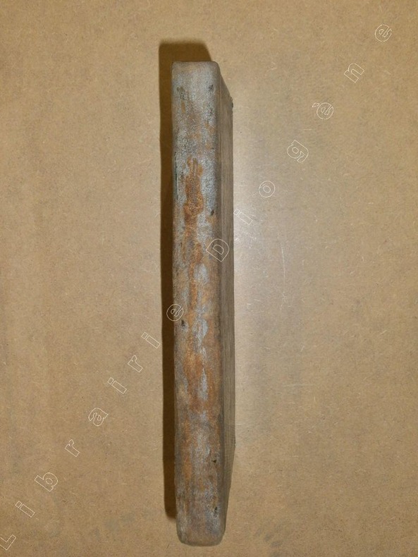
DERIBIER
Dictionnaire topographique de la Haute-Loire ou nomenclature par ordre alphabétique, de tous les lieux habités du département, indiquant leur population, le nombre des maisons, la distance des chefs-lieux de communes à ceux de canton, d'arrondissement et du département. Suivi d'un itinéraire des routes royales et départementales ; d'un annuaire ou état du personnel des administrations religieuse, judiciaire, civile et militaire ; d'un tableau statistique des foirezs et marchés. Rédigé sur les documens officiels, recueillis d'après les ordres de M. Armand de Bastard, maître des requêtes, préfet du département.
1820 J.G. Guilhaume, 1820, vji p., 8 p., 253 p., demi-basane, environ 21x13, dos complètement épidermé, bords des plats frottés, coins émoussés, intérieur propre.
書籍販売業者の参照番号
: 88983
|
|
|
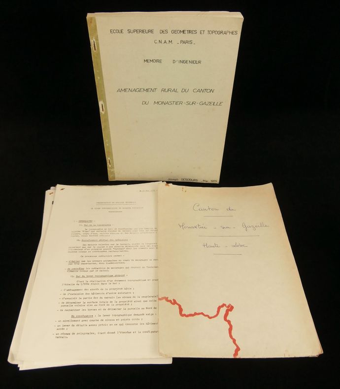
DESCOURS Joseph
AMENAGEMENT RURAL DU CANTON DU MONASTIER-SUR-GAZEILLE ( Haute-Loire).
Cahier agrafé d'un format 295x208mm , 1975, 78 pages tapuscrites + divers feuillets libres, l'ensemble est en bon état.
書籍販売業者の参照番号
: 4664
|
|
|
DESCOURTIS sc. d’après WOLF Pinx. :
Seconde Chute du Staubbach. Dédiée à Monsieur G. May, Colonel...
Amsterdam, R. Hentzi / Yntema, s.d. 1785, 33x22 cm (Vue), aquatinte tirée en couleurs, Passepartout - Encadrement or. (60x45 cm).
書籍販売業者の参照番号
: 100737aaf

|
|
|
DESCOURTIS sc. d’après WOLF Pinx. :
Vue du Schild-Wald-Bach. Prise en Hyver. Dédiée à Mr. Van der Goes...
Amsterdam, R. Hentzi / Yntema, s.d. 1785, 33x22 cm (Vue), aquatinte tirée en couleurs, Passepartout - Encadrement or. (60x45 cm).
書籍販売業者の参照番号
: 100734aaf
|
|
|
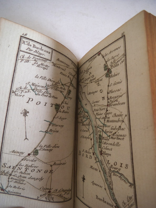
DESNOS Charles
Etrennes utiles et nécessaires aux commerçants et voyageurs
Etrennes utiles et nécessaires aux commerçants et voyageurs ou indicateur enseignant toutes les routes Royales et particulières de la France, et les chemins de communication qui traversent les grandes routes : les villes, bourgs, villages, hameaux, châteaux, abbayes, hôtelleries, rivières, bois et les limites de chaque province distinguée. Dédiées au Roi. Ouvrage rendu si complet, tant pour le détail topographique, que pour l’exécution que les amateurs y trouveront tout ce qu’ils peuvent désirer. A Paris chez S. DEDNOS ingénieur géographe et libraire de S.A Danoise Rüe st Jacques, au globe 1774.Dernière édition, corrigée, at augmentée. Frontispice gravé, titre avec encadrement, gravés, carte générale des routes de France (sur double page) Carte des environs de Paris sur doble pages) 150 cartes rehaussées en couleurs table des routes contenus dans ce recueil. (9 pages) 1 pages de remarques, 6 cartes en couleurs, 9 pages additions de la table. 2 pages avis, 24 pages blanches (pour annotation). En volume in 16 plein chagrin rouge pièce de titre chagrin vert, fers, roulette, filets dorés ; Roulette dorée encadrant les plats, filet doré sur coupes, dentelle dorée intérieure, tranches dorées. Très bon état d’ensemble, superbe état des cartes, coloris frais.
書籍販売業者の参照番号
: 12565
|
|
|
DETSICAS A. P.
Excavations at Eccles 1972. Eleventh Interim Report. SIGNED PRESENTATION COPY
8vo., First Edition thus, with 8 plates on 4 and a large folding plan; original printed wrappers, wire-stitched as issued, a near fine copy. A PRESENTATION COPY FROM THE AUTHOR WITH HIS SIGNED HOLOGRAPH INSCRIPTION ON INSIDE FRONT WRAPPER. Offprinted from Archaeologia Cantiana, Vol. LXXXVIII, 1973.

|
|
|
DETSICAS A. P.
Excavations at Eccles 1973. Twelfth Interim Report. SIGNED PRESENTATION COPY
8vo., First Edition thus, with 4 plates on 2 and a large folding plan; original printed wrappers, wire-stitched as issued, a near fine copy. A PRESENTATION COPY FROM THE AUTHOR WITH HIS SIGNED HOLOGRAPH INSCRIPTION ON INSIDE FRONT WRAPPER. Offprinted from Archaeologia Cantiana, Vol. LXXXIX, 1974.

|
|
|
DETSICAS Alec
The Cantiaci. [Second Impression]. NEAR FINE COPY IN UNCLIPPED DUSTWRAPPER
8vo., Second Impression, with frontispiece map, and photographs, illustrations and plans throughout; black cloth, gilt back, a near fine copy in unclipped dustwrapper.

|
|
|
Deutsche Hydrographisches Institut Hamburg (Hrsg.)
Nordsee - Deutsche Küste - Nordfriesische Inseln: Hever und Schmaltief. Topographische Karte im Format 120 x 78 cm.
Hamburg, Deutsche Hydrographisches Institut, 1963. Mehrfarbige Original-Karte, mehrfach gefaltet, Format: 120 x 78 cm. Maßstab: 1 : 50.000.
書籍販売業者の参照番号
: SB-09311

|
|
|
Deutsche Hydrographisches Institut Hamburg (Hrsg.)
Nordsee - Deutsche Küste: Die Eider, Norder- und Süderriep. Topographische Karte im Format 100 x 74 cm.
Hamburg, Deutsche Hydrographisches Institut, 1960. Mehrfarbige Original-Karte, mehrfach gefaltet, Format: 100 x 74 cm. Maßstab: 1 : 50.000.
書籍販売業者の参照番号
: SB-09312

|
|
|
Deutscher und Österreichischer Alpenverein DOAV (Hsg.)
[Nördliche Kalkalpen, bzw. Ostalpen, bzw. Allgäuer- und Lechtaler Alpen].
Wien, Freytag & Berndt (u.a.) 1899-1958. 19 div. farb. (Falt-) Karten, grösstenteils im Massstab 1 : 25'000, in div. Formaten. Leichtere Alters- u. Lagerungs-, weniger eigentliche Gebrauchsspuren. Gesamthaft saubere, recht gute Exemplare in attraktivem priv. Schuber. Alle mit Exlibris auf Vorderseite.
書籍販売業者の参照番号
: LR110791

|
|
|
Deutscher Werkbund
Der Main. Gefährdung und Chancen einer europäischen Flußlandschaft.
München, Deutscher Werkbund, 1980. 227(1) SS. 8°, illustr. orig.-Paperback.
書籍販売業者の参照番号
: 22613
|
|
|
DEVON ARCHAEOLOGICAL SOCIETY
Devon Archaeology No. 3. Dartmoor Issue. NEAR FINE COPY
8vo., First Edition, with photographs and maps in the text, a few leaves mildly age-soiled; original pictorial wrappers, wire-stitched as issued, a near fine copy.

|
|
|
DEVONSHIRE ARCHAEOLOGICAL SOCIETY
Archaeological Notes. Reprinted from DAS Proceedings No. 48. FINE COPY
8vo., First Edition, with photographs, illustrations and maps in the text; original printed wrappers, wire-stitched as issued, yapped edges, a fine copy. Contains Robinson, Griffiths & Cosford: The Corringdon Multiple Stones Rows; Henig: A Roman Signet Ring from Pennslyvania, Exeter; Henig: A Roman Gold Serpent Ring from Heath Farm, Spreyton; Keen: Fifteenth-Century Floor Tiles from Spreyton and Throwleigh.

|
|
|
DEVONSHIRE ARCHAEOLOGICAL SOCIETY
Devon Archaeological Society. Proceedings No. 48. FINE COPY
8vo., First Edition, with photographs, illustrations and maps in the text; original printed wrappers, a fine copy.

|
|
|
DEVONSHIRE ARCHAEOLOGICAL SOCIETY
Devon Archaeological Society. Proceedings No. 49. 1991
8vo., First Edition, with photographs, illustrations and maps in the text; original printed wrappers, a fine copy.

|
|
|
DEVONSHIRE ARCHAEOLOGICAL SOCIETY
Devon Archaeological Society. Proceedings No. 50. 1992
8vo., First Edition, with photographs, illustrations and maps in the text; original printed wrappers, a fine copy.

|
|
|
DEWEZ Léon et alii
"La Cour des Mineurs à Liège. Musée de la vie wallone; Service éducatif."
Liège, Editions du Musée de la Vie Wallone, 1968. 14 x 22, 66 pp., quelques illustrations en N/B, broché, bon état.
書籍販売業者の参照番号
: 61836
|
|
|
Di Castri Gianluca
Project management per l'edilizia. Ingegneria economica: applicazioni e sviluppo
ill., br. Quest'opera è uno strumento di formazione non soltanto per i project manager, ma anche per tutti coloro che operano nell'edilizia: vengono infatti definiti i principi di integrazione fra le funzioni aziendali nell'ambito di un'organizzazione di progetto. Lo stesso progetto è visto come parte del più ampio sistema aziendale. Si tratta quindi di un testo innovativo, perché inquadra il project management nello schema concettuale dell'ingegneria economica, total cost management, e nel contempo formativo, perché chiarisce al lettore come applicare il project management in edilizia, proponendo conoscenze e strumenti concettuali.

|
|
|
Di Macco Sergio, Mattera Pier Luigi.
L'INVENTARIO DEL TERRITORIO. Una nuova forma di catasto e di registrazione.
(Codice AC/3416) In 8° 287 pp. Brossura editoriale, stato di nuovo. ~~~ SPEDIZIONE IN ITALIA SEMPRE TRACCIATA

|
|
|
Di Marco, Liana
Spoleto: Una Città-Cantiere Durante il Ventennio. Album Di Storia Urbana 1922-1943
Mm 220x305 Volume rilegato in tela con sovraccoperta, 160 pagine con figure in nero ed una carta della città a colori in chiusura. Una firma in apertura, peraltro copia in condizioni pari al nuovo. SPEDIZIONE IN 24 ORE DALLA CONFERMA DELL'ORDINE.
|
|
|
DI TUCCI Raffaele -
Brevi cenni storici su Cornus.
Firenze, 1959, 8vo stralcio con copertina posticcia muta, pp. 95/106. - !! ATTENZIONE !!: Con il termine estratto (o stralcio) intendiamo riferirci ad un fascicolo contenente un articolo, completo in se, sia che esso sia stato stampato a parte utilizzando la stessa composizione sia che provenga direttamente da una rivista. Le pagine sono indicate come "da/a", ad esempio: 229/231 significa che il testo è composto da tre pagine. Quando la rivista di provenienza non viene indicata é perché ci è sconosciuta. - !! ATTENTION !!: : NOT A BOOK : “extract” or “excerpt” means simply a few pages, original nonetheless, printed in a magazine. Pages are indicated as in "from” “to", for example: 229/231 means the text comprises three pages (229, 230 and 231). If the magazine that contained the pages is not mentioned, it is because it is unknown to us.

|
|
|
Diana Bowerman:
HISTORIC THAMES VALLEY TAVERNS
Fine/Vg (light edgewear to price clipped dj and back cover lightly marked, clean orange cloth with bright gilt titles on spine, contents fine, no inscriptions) octavo 160pp. First edition. Maps to endpapers, many b/w photographs.
|
|
|
DICK C.H.
Highways and Byways in Galloway and Carrick. With Illustrations by Hugh Thomson. FIRST POCKET EDITION IN PUBLISHER'S CALF
Sm. 8vo., First Edition thus, with frontispiece, very numerous illustrations in the text and large folding map; publisher's limp brown calf, upper board and backstrip blocked and lettered in gilt and blind, gilt top, brown silk marker, a very good, bright, clean copy. One of the scarcer titles in this much sought-after series. Spielmann & Jerrold, 60.

|
|
|
DICK C.H.
Highways and Byways in Galloway and Carrick. With Illustrations by Hugh Thomson. THE ORIGINAL EDITION WITH MAP CORRIGENDA
8vo., First Edition, with frontispiece, very numerous illustrations in the text and large folding map (two neat repairs on inner surface); original series binding of blue cloth, upper board lettered in gilt, gilt back, gilt top, a very good, bright, clean copy. With the separately printed map corrigenda slip mounted facing map, and 4pp series catalogue bound in at end. One of the scarcer titles in this much sought-after series. Spielmann & Jerrold, 60.

|
|
|
DICKINSON (William)
Antiquities Historical, Architectural, Chronological, and Itinerary, in Nottinghamshire and the adjacent Counties; comprising the Histories of Southwell (the Ad Pontem) and of Newark (the Sidnacester, of the Romans) interspersed with Biographical Sketches, and profusely embellished with engravings, in Four Parts. Part I. [and II]. Vol.1. [all published].
First edition, 2 parts in one, 4to (275 x 215 mm), xiv, 8, [2], 115, [1]; [117]-344pp., portrait frontispiece, folding map, 21 plates, 17 pedigrees (6 folding), nineteenth century half calf, upper cover detached. These two parts [Southwell] are almost invariably bound together. "The History of Newark." referred to in the title was not published until 1819 and then as a separate publication. Provenance: Armorial bookplate of Roger Pocklington; inscribed from M. C. Pocklington, 1873. Dobbin, 500.
|
|
|
Dickinson, J C
The Land Of Cartmel - A History
Titus Wilson & Son, Kendal 1980. 1112 Seiten. 26*19 cm. OPappband, OSchu.
書籍販売業者の参照番号
: 144691

|
|
|
Diderot & D'Alembert.
GRAVURE EN LETTRES, EN GEOGRAPHIE ET EN MUSIQUE. Contenant deux planches. "Recueil de planches sur les sciences, les arts libéraux, et les arts mechaniques, avec leur explications".
(Codice AN/3406) Deux planches originales in folio (43x27 cm). Edition 1771, illustrée de nombreuses gravures par Bernard; avec 3 pags d'explication (très détaillées), texte sur deux colonnes. Sur papier pur chiffon à la cuve, grandes marges non rognés. Très bon état. Jointe photocopie de la page de titre du volume. ~~~ SPEDIZIONE IN ITALIA SEMPRE TRACCIATA

|
|
|
Die Stadt Rom. - Kiepert, Heinrich / Kiepert, Richard (del.)
Roma Urbs inde ab imp. Augusti aetate cum muris ab impp. Aureliano et Honorio conditis. Karte im Maßstab 1:15 000. Blatt XXII aus dem Werk "Formae orbis antiqui" von Heinrich Kiepert. Mit Text von Richard Kiepert.
Sumtus fecit libraria geographica Diterici Reimer ( Ernesti Vohsen ) Berolini 1903, d.i. Dietrich Reimer (vormals Ernst Vohsen) in Berlin 1903. Landkarte mit der Blattgröße 64 x 51 cm. Grenzkoloriertes Originalblatt. Kartengröße 55x43 cm zzgl. Über- und Unterschrift. Das Blatt enthält 2 Karten: Rom-Fines regionum ab Augusto institutarum im Maßstab 1:15 000 und die Karte Pars Media Urbis Romae- circa Forum et Capitolium im Maßstab 1: 5000. Auf der oberen Rom-Karte sind diverse Bauten mit Zahlen versehen, unten rechts eine Legende mit den Erläuterungen. Rückseitig oben rechts mit gedrucktem Kartentitel und der Blattnummer und mittig gestempelt mit "Seminare f. Staatenkunde u. hist. Geographie-Universität Berlin" der Humboldt-Universität und "Ausgesondert". Die Karte mittig quer gefaltet, am rechten Faltrand kleiner Einriss, im Randbereich kleine Faltstellen. Die Textblätter in der Größe 51 x 31,5 cm, 4 Seiten bedruckt, zweispaltig gesetzt. Die Karte komplett lateinisch beschriftet, der erläuternde Text in deutsch. Auf Seite 1 oben mittig mit Stempel wie auf der Karte. Sauberes und wohlerhaltenes Exemplar.
書籍販売業者の参照番号
: 501963

|
|
|
Diercke, C. - Gaebler, E.
Diercke, Schul-Atlas für höhere Lehranstalten. 38. Auflage. 159 haupt- und 156 Nebenkarten.
Brausnschweig, George Westermann 1902, 365x220mm, Verlegereinband.
書籍販売業者の参照番号
: 27838

|
|
|
DIERCKE, C. - GAEBLER, E.
Diercke, Schul-Atlas für höhere Lehranstalten. 41. Auflage. 159 haupt- und 156 Nebenkarten.
Brausnschweig, George Westermann 1905, 365x220mm, Verlegereinband.
書籍販売業者の参照番号
: 71124

|
|
|
Diest, W. v.; Anton, M
Neue Forschungen im nordwestlichen Kleinasien. [Hrsg.:] Petermann, August. [Mittheilungen [Mitteilungen] aus Justus Perthes' Geographischer Anstalt über wichtige neue Erforschungen auf dem Gesammtgebiete [Gesamtgebiete] der Geographie. Ergänzungsheft Nr. 116].
Gotha, Justus Perthes 1895. 4°. II, 131 pp., 3 Faltkarten. Neuere Interimsbroschur. Vom Schnitt her etwas angestaubt.
書籍販売業者の参照番号
: 6046037
|
|
|
Dillingen
Repertorium des topographischen Atlasblattes Dillingen (und Elchingen). Ohne Ort. Ohne Verlag. 1831. 8°. 107 SS. u. 2 mehrfach gefaltete, gestochene Karten (jeweils 51:79 cm). Umschlag der Zeit. Die beiliegenden, zugehörigen Karten je in 16 Segmente auf Leinwand aufgezogen. Stellenweise leicht stockfleckig.
o.J.
書籍販売業者の参照番号
: 22246
|
|
|
DINELEY D. L.
Shropshire Geology. An Outline of the Tectonic History. BRIGHT, CLEAN COPY
8vo., First Edition, with maps in the text; laminated printed wrappers, wire-stitched as issued, a good, clean copy. Reprinted from Field Studies, Vol. I. No 2. Sold from an institution with its neat press-mark on title.

|
|
|
DIPLOCK William
The Hastings Guide; containing a Description of that Ancient Town and Port. and the Romantic Scenery in the Environs. With a Table of Distances, an Account of the Cinque Ports and a minute Detail of the famous Battle of Hastings. The Sixth Edition, with considerable Alterations and Additions. EXTRA-ILLUSTRATED COPY IN ORIGINAL BOARDS
8vo., Sixth Edition, with engraved folding map as frontispiece, 12 engraved plates and engraved folding map; original blue boards, upper board with printed paper label, expertly rebacked in ivory paper to style, uncut, a remarkably well-preserved, bright, crisp, clean copy. With the publisher's advertisement leaf bound in at rear. THIS COPY IS EXTRA-ILLUSTRATED by the insertion of a folding engraved map of the Town and Port, and an additional engraved view of Pelham Place and Crescent. The plates depict: View from Minnis Park, View from the East Well, View from the Pier Rocks, View in East Bourn Street, St. Clement's Church, Town Hall, Remains of the Town Hall, North West View of the Castle, Marine Parade, Pelham Place, Pelham Place and Crescent, View from the White Rock. Anderson records two versions of the Hastings Guide, but states no publishers. The likelier of the two, in 8vo rather than 12mo format, gives third edition as 1824 with subsequent issues from 1825 to 1830. Halkett & Laing and NUC assign authorship of earlier editions (eg. 1794) to James Stell. EXTREMELY SCARCE, ESPECIALLY IN THIS CONDITION.

|
|
|
Disselkamp, Martin
"Nichts ist, Rom, dir gleich" : Topographien und Gegenbilder aus dem mittelalterlichen und frühneuzeitlichen Europa. Stendaler Winckelmann-Forschungen ; Bd. 10 ERSTAUSGABE.
Ruhpolding ; Mainz : Rutzen, 2013. 259 Seiten. Mit zahlreichen farbigen Abbildungen. Index 27 cm Originalpappband.
書籍販売業者の参照番号
: 252356

|
|
|
Disselkamp, Martin
"Nichts ist, Rom, dir gleich" : Topographien und Gegenbilder aus dem mittelalterlichen und frühneuzeitlichen Europa. Stendaler Winckelmann-Forschungen ; Bd. 10 ERSTAUSGABE.
Ruhpolding ; Mainz : Rutzen, 2013. 259 Seiten. Mit zahlreichen farbigen Abbildungen. Index 27 cm Originalpappband.
書籍販売業者の参照番号
: 252355

|
|
|
DITCHFIELD P.H.
English Villages. Second Edition.
8vo., Second Edition, with a frontispiece, 15 plates and numerous illustrations in the text; original blue cloth, gilt back, uncut, a very good, bright, clean copy. With 40pp publisher's catalogue bound in at end. Ditchfield's classic study was first published in 1901.

|
|
|
DITCHFIELD, ed. P. H.
Memorials of Old Oxfordshire. BRIGHT, FIRM COPY
8vo., First Edition, on laid paper, with a frontispiece, 22 plates and numerous line illustrations in the text, half-title and title spotted, some light marginal spotting throughout, neat signature on front free endpaper; original ivory buckram, sides with double frame border in gilt enclosing lettering in red and black and series medallion in gilt, backstrip lettered in red and black and ruled in gilt, bevelled edges, gilt top, uncut, patterned endpapers, backstrip lightly browned, tiny split in upper hinge else a very good, firm, clean copy. With personal bookplate on front paste-down. Published in Bemrose's invaluable 'Memorials of' series, collating twenty-one extended historical accounts. Cordeaux & Merry 203.

|
|
|
Dithmar, Georg Theodor
Aus der Vorzeit Marburgs und seiner Umgegend. Denkwürdige Sagen und Geschichten. Mit der Photographie des Freiherr J. W. von Spiegel zum Desenberg.
Marburg, Braun, 1872. 8°, mit einer Photogrphie, VIII, 140 Seiten (Orig. farbige Broschurdeckel mit eingebunden), HLdr. d. Z
書籍販売業者の参照番号
: 7-2-595
|
|
|
Dittebrand-Schmitt (Vorwort)
700 Jahre Pfarrgemeinde Sambach. Pfarrchronik St. Antonius zu Sambach.
Sambach, im Selbstverlag, ohne Jahresangabe (!), wohl um 1980. 80 SS., zahlreiche s.w. Abbildungen. 8°, illustr. Orig.-Broschur.
書籍販売業者の参照番号
: 23152
|
|
|
Diverse
Brunn's Neuester Plan von München mit Hausnummern. Und Straßenverzeichnis.,Nymphenburg mit botanischem Garten. Angabe der Sehenswürdigkeiten.,
Brunn:München.0. 13 Seiten.19 cm x 12 cm. Originalbroschur
書籍販売業者の参照番号
: K42085

|
|
|
 検索結果のメールを受信する
 PDFファイルの検索結果をダウンロード
 RSSフィード


