|
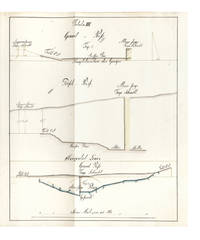
Verzeichniss der Höhen-Fixpunkte im Gebiete der Stadt Zürich. Herausgegeben vom Vermessungsamt der Stadt Zürich
Zürich, Museumsgesellschaft Zürich, 1895. 8°. 166 S., mit vielen ganzseitigen Abbildungen. Halbleinenband mit handschriftlichem Bibliotheks-Rückenschild. + Wichtig: Für unsere Kunden in der EU erfolgt der Versand alle 14 Tage verzollt ab Deutschland / Postbank-Konto in Deutschland vorhanden +, 4834DB|4834DB_2 [2 Warenabbildungen]
書籍販売業者の参照番号
: 4834DB

|
|
|
(CLAUSTHAL: MINE SURVEYING)
Manuscript on paper on mine surveying with 12 large & fine folding manuscript plates heightened in grey blue pink & yellow wash
40 leaves the final blank. Small folio 332 x 210 mm. orig. paste-paper boards spine & extremities somewhat worn uncut. Clausthal: ca. 1815.<br/> <br/> A fine and legible manuscript instructional manual on techniques and problems of mine surveying. The text is divided into five chapters: “Von der Vorbereitung zum Markscheiden†“On preparations for measuring the area in which mining may be carried out†“Von Bennenung der Gänge und Klüfte†“On the naming of seams and fissures†“Vom Observiren†“On Observations†“Vom Vermaß oder Verbestimmung eines Grubenfelds†“On measuring and defining a mining claim†and “Von Wasserfällen Wasserleitungen und Tiefbau†“On waterfalls water conduits and underground miningâ€.<br/> <br/> This manuscript was probably prepared in 1815 — plate X has the entry “Markscheide 1.7.15“ — at the newly founded mining school at Clausthal the famous mining town of the Harz Mountains in Lower Saxony the fine plates name mining locations in the area.<br/> <br/> The most attractive plates — all of which contain a number of figures — depict mine shafts mine surveying methods cartographical considerations techniques of prospecting and identification of mineral deposits problems of ownership rights and the constant problems of flooding. All the plates are finely drawn in black ink and have been heightened in grey blue pink and yellow wash.<br/> <br/> Internally fine. Stamp of Georg Riemschneider 1888-1946 “Oberbergrat†of Clausthal-Zellerfeld. unknown
書籍販売業者の参照番号
: 6396
|
|
|
(Surveying) Love, John
Geossia: or The Art of Surveying and Measuring of Land Made Easy .
London: Printed for A Bettesworth and C. Hitch . and W. Innys 1731. The Fourth Edition. Diagrams. xx 196 16 4 36 8 pp. 1 vols. 8vo. Contemporary calf red leather spine label. Boards missing else clean. Signed Wm. G. Barrows. Brunswick Maine Dec. 16 1882. The Fourth Edition. Diagrams. xx 196 16 4 36 8 pp. 1 vols. 8vo. Printed for A Bettesworth and C. Hitch ... and W. Innys unknown
書籍販売業者の参照番号
: 223283
|
|
|
-0
Dialogo sulle stime censuarie nella pianura bolognese, inserito nel fattore di campagna. Artic. Io Vol. IIo
In 16, pp. 30. Br. ed.
|
|
|
0
MANIFESTO DEL MAGISTRATO DELLA RIFORMA RIGUARDANTE GLI STUDI, ESAMI ED ESERCIZI rispettivamente degli agrimensori, misuratori, architetti civili ed idraulici. in data de 9 Marzo 1762
In 4, pp. (4). Stemma xil. Esposizione delle modalita' di ammissione e di esame per Agrimensori, Misuratori, Architetti civili e architetti idraulici. Ai primi due era richiesta una pratica di tre anni presso un misuratore e due presso un agrimensore, agli architetti invece veniva richiesta la fede dell'aver fatto un corso di geometria e meccanica entre agli idraulici era richiesto un corso di matematica.
|
|
|
[California - Gold Rush - Surveying - Personal Archives] Williams, Edward
Gold-Rush-era Archive of Surveyor Edward Williams including Thirteen Letters Written from Monterey in 1850 a Transcribed Copy of a Mexican Land Grant from 1834 and Notes Relating to his Work as a Surveyor
California 1850. With thirteen letters most multi-page written from Monterey in 1850 a 7 pp facsimile transcription of a 1834 Mexican land grant on cloth measuring 11 x 14 inches and and eleven page document on paper in Spanish relating to a Monterey land grant transcribing an 1841 document. Letters heavily worn with some loss at margins but mostly legible land grant in good to very good condition transcribed document in Spanish in fair condition with water damage to margins. Fair. An interesting archive of 1850s-era material relating to the life and career of the surveyor Edward Williams which recently surfaced in the central mother lode region. The group includes his personal letters from the California Gold Rush as well as well two interesting documents form his work for the Surveyor General J.W. Mandeville in 1858 where he transcribed two Mexican land grants. <br /> <br /> Lt. Edward Williams was a member of Company E New York Volunteers under Capt. Nelson Taylor. He came to California around 1847 and found employment as a deputy surveyor later working for the Office of the Surveyor General of the Unites States for California. In 1858 Surveyor General J.W. Mandeville commissioned a report on Mexican-era California Land Grants. Mandeville had Williams copy the original documents exactly - inclusive of an ink copy on linen that is an "exact tracing" of the original documents starting with 1834 up through about 1840. These "copies" were submitted to the Surveyor General in 1858 for use in the report. Williams continued the title work by copying other documents from about 1841 though this time not as a tracing but hand copied on the usual blue paper of the 1850s.<br /> <br /> The documents illustrate the length officials went to while they investigated Mexican Land Grant titles to California properties in the 1850s. The process was difficult and involved two distinctly separate cultures and legal systems that clearly conflicted. The Mexican Government granted rights for these large land parcels in California to various people but clearly stated they could not sell parts of the property. The wording was used many times in litigation of the period in both defense of the land grants and in opposition to how the land grants were handled. The issues were actually quite simple in that the Mexican legal standards for land grants was far different from those in the United States and the two differing forms of written land ownership and use clashed. <br /> <br /> These documents reflect a parcel of land granted to Francisco Mesa at "Corral de Tierra" a large parcel in Monterrey County California. Mesa had requested land for "his personal use and that of his family." In the Grant the title papers reflect "while the land is under Francisco's possession it cannot be divided mortgaged or a levy placed on it nor handed down." These original documents help illustrate the complex story of Mexican Land Grants in California. <br /> <br /> Also included are thirteen letters from Ed aka "Ned" to various family members primarily his mother and sister Alice and vice versa. About half are from Ed the other half are written to him. The dates of the letters are; 1850: February 10th April 15th April 16th April 28th June 10th July 30th October 11th and November 17th and 1851: September 9th. One undated letter with heavy loss is written from Panama. The letters are generally readable but the condition far from perfect with water stains throughout and chips abundant along edges and significant textual loss. The letters are generally at least two pages sometimes four or more inclusive of writing in the crossed line custom to save paper. Most are datelined at Monterrey where he discusses the people the customs setting and more. <br /> <br /> Despite the condition flaws there is much to be gleaned from his correspondence. In his April 15 1850 letter . he describes his trip to San Juan Bautista from Monterrey in detail while he was on his way to San Francisco. Williams writes of his great pleasure on tasting cooked beef by the Indians that he found was the best he ever tasted as they camped on the way to San Jose with the ultimate goal Mission Dolores in San Francisco: “this the beef they put on the embers of the fire and broiled it - I never tasted anything like it before so tender so juicy…†One of his first notes on San Francisco: "There are regular streets filled with all kinds of sorts of stores… The shipping covers the water as far as you can see. And those nearest the shore are converted into store houses the rigging being taken down and the and holes cut in the sides for doors.The best houses in town are occupied by gamblers . a large saloon filled with tables on which are played all kinds of games of chance - at some of the tables are displayed immense amounts of coin and gold in lumps worth from 1 to 5000 dollars which some poor infatuated fool of a miner has at some time lost to them."<br /> In his letter of April 16th he discusses both his difficulties with women in California and his lack of fitting in back east: “The Spanish Girls are very nice and all that sort of thing but the trouble is to find one that is educated. I can’t bear an uneducated wom an and I think I shall have to come to N.Y. and bring one out here… I know one or two in N.Y. but I don’t believe they would have such an uncouth specimen of an ‘hombre’ as me…†In his next letter he describes Carmel in detail. He states: “I haven’t been to the mines nor have I any inclination to go†though he intends to settle in California permanently. In his next letter he discusses the people he’s met and how he detests the anglophone community there: “How do I like the People Those of Spanish whom I call my friends I love with all my soul - there is not much society except among them… the Eng. and Am. population I detest from the bottom of my heart. This may sound strange but you will know the por que when you arrive.†He then praises the climate and scenery of Monterey. One letter written from Panama which has unfortunately sustained heavy losses at margins offers some details of the trip on the Chagres River. The replies to Williams from his family offer details on life in New York and are similarly compromised in condition but overall there is enough to glean from the group to provide a detailed example of family correspondence from the period. <br /> <br /> Overall a very interesting and unusual archive of a young professional who moved to California during the Gold Rush period and rejected the Anglophone mining community with particular interest to historians of Monterey and of the systems of land grants that shaped Mexican and American land policy in the nineteenth century. unknown
書籍販売業者の参照番号
: List1929

|
|
|
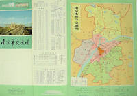
[NANJING MUNICIPAL INSTITUTE OF SURVEYING AND DESIGN]. 南京市勘测设计院.
南京市交通图. Nanjing shi jiao tong tu. Naning City Transportation Map.
No place of publication.: 江苏人民出版社.Jiangsu ren min chu ban she. 1st Edition 2nd Printing. 1977. Colour Chinese transportation map featuring the city of Nanjing capital city of Jiangsu Province and its surrounding regions. Upper side: A transpiration map of Nanjing and neighbouring counties right section with a list of names of stations buses trains coaches ferries and their addresses lower right edge tourist guide including the addresses and phone numbers of major travel agents hospitals cinemas and more left section accompanied by two tables of bus routes. On reverse: a "Map of Nanjing Municipal Transpiration Map" scale not given a chart of terminus for bus and trolley bus lower right section. Some soiling on reverse stamp of a prior dealer in Guangzhou a handwritten date of "September 17th 1977" upper side light creases good copy. Text in Chinese. Sheet measures 37.8 x 52.3cm. . 江苏人民出版社.[Jiangsu ren min chu ban she]. unknown
書籍販売業者の参照番号
: 137003
|
|
|
[STATE SURVEYING AND MAPPING DEPARTMENT].
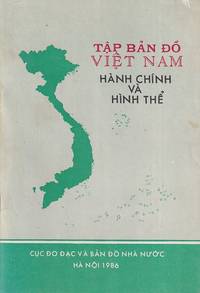
Tập Bản Đố Việt Nam. Hành Chính và Hình Thể. Atlas of Vietnam. Administrative and Physical Geography.
Hà Nội.: Cục Đo Đạc và Bản Đố Nhà Nườc. 1986. 13 colour maps with 5 inset maps. 23pp. 19.5 x 13cm. Paperback covers little shelf worn and marked though overall a very good copy. A pocket-sized atlas of Vietnam prepared only 10 years following the reunification of the North and South. Indicative of a nation reorienting towards asserting her territorial claims in the South China Sea the entirety of the Paracel and Spratly Islands have been painstakingly noted with their Vietnamese names. . Cục Đo Đạc và Bản Đố Nhà Nườc. paperback
書籍販売業者の参照番号
: 222320
|
|
|
[SURVEYING]. FLINT, Abel & GILLET, George
A system of geometry and trigonometry: with a treatise on surveying in which the principles of rectangular surveying without plotting are explained. . . .
Hartford CT: Belknap and Hamersley 1844. 8vo. 160; 112 pp. Numerous woodcut engraved diagrams figures. Contemporary full speckled calf speckled fore-edges tan & gilt morocco spine label minor shelfwear slight rubbing occasional light foxing still an excellent copy. Third edition revised & expanded of this popular American treatise on surveying published originally in 1804 would continue to be updated and revised for over half a century. An edition of Abel Flint’s work was one of the two consulted by Abraham Lincoln while he studied to become a surveyor as it emphasized higher math including logarithms plane geometry and trigonometry. Belknap and Hamersley, unknown
書籍販売業者の参照番号
: 55840
|
|
|
[Surveying Teams - Dakota - 1890s] Newcombe, CH C H
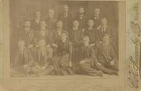
Cabinet Card Photograph of the Staff of the Surveyor General’s Office in South Dakota
Huron 1891. Albumen photograph measuring 5 ½ x 4 inches on larger mount. Some fading very good overall. A scarce and possibly image from the post-statehood Surveyor-General’s office. Surveying in the Dakota Territory and in the early statehood period was quite difficult due to the terrain and the abundance of privately held mining claims. This photograph shows an early South Dakota office led by General B.H. Sullivan. Included in the picture is Miss Eva Jackson the Assistant Transcribing Clerk. unknown
書籍販売業者の参照番号
: List2113
|
|
|
[SURVEYING -- SCIENTIFIC INSTRUMENTS]. BACHMANN, F
Die Theorie und Praxis des Nivellirens mit besonderer Rucksicht auf Libelleninstrumente. . . .
Weimar: Bernhard Friedrich Voigt 1838. 8vo. 239 1 pp. Numerous tables. Six large folding engraved plates some hand-coloured w/ instruments and cartographic details. Contemporary quarter-tree-calf over chppng ft of spine mnr splttng to hnges foxing to textblk mnr creasng to Plate VI still good reference copy. First edition of this exceedingly scarce work on surveying detailing the equipment and leveling instruments w/ details on cartography. Bernhard Friedrich Voigt, unknown
書籍販売業者の参照番号
: 38922
|
|
|
[TRIGONOMETRY and SURVEYING].
18TH C SURVEYING MANUSCRIPT WITH HAND-COLORED ILLUSTRATIONS <br> Géométrique pratique.
<p>Manuscript 4to. 23.5 x 17.5 cm 2 ff. pencil sketch of arms Marlborough and blank 196 ff. and with 27 drawn folding plates many of which are colored. Bound in contemporary French calf spine gilt in six decorative compartments with title on letterpiece. Excellent with all plates drawn and many some colored in a very professional hand.<br /><br /></p><p>Very attractive early 18th-century French illustrated manuscript of practical geometry in seven books including individual sections on longimetry planimetry and stereometry—the fundamentals of precision surveying and draftsmanship. The manuscript closely follows but is not identical to Jacques Ozanam's <i>Géométrie Pratique du sr Boulenger</i> Paris 1684 which itself was a revision of <i>La Géométrie pratique </i>Paris 1640 by the mathematician Jean Boulenger. Though the work was reprinted well into the 18th C the present volume seems to follow Ozanam's 1693 edition most closely. Ozanam's book however lacks the drawn and colored figures of the present volume many of which are quite elaborate. The facade of Notre Dame is shown in an exercise for calculating the height of a wall and a segment on proportion features detailed miniature maps of the Brittany coastline identifying towns such as St. Malo and Mont St. Michel. <br /></p><p>The manuscript exemplifies the early 18th C approach to applied trigonometry—a field that by the mid-17th C was starting to resemble an exact science. Book II defines the common functions sine cosine secant etc.; Book V treats longimetric puzzles such as determining the height of a mountain or a spire or measuring the length of bodies of water; the final two books treat planimetry and stereometry including applied trigonometry—calculating the volumes of real bodies i.e. barrels pipes etc. Those sections of the manuscript that do not appear in <i>Géométrie Pratique</i>—mainly a tract on logarithms and a discussion of surveying instruments—also fall within Ozanam's oeuvre as he published a monograph on compasses in 1673 and a book of logarithmic tables and trigonometric functions in 1685.</p><p>Jacques Ozanam 1640-1717 was best known for his <i>Récréations mathematiques</i> Paris 1694 which "may be regarded as the forerunner of modern books on mathematical recreations." In addition to Boulenger's work he also revised that of Adriaan Vlacq 1600-1667 and the Jesuit mathematician Claude-François Milliet Dechalles.</p> DSB.10 pp.263-265. [France, early 18th century].
書籍販売業者の参照番号
: 2805

|
|
|
[Unidentified German Army "Motorized Surveying and Map Detachment" / Vermessungs- und Karten-Abteilung Motorisiert]
UKRAINE - Two Unrecorded Nazi Wehrmacht Field Printings of Kyiv. "Blick v.d. Lissa Gora auf die Stadt Kijew" Together with: "Blick v.d. Zitadelle Lawra nach Osten und Nordosten
Kyiv 1941. Very good. Together 2 views 205 x 325 mm; 8" x 13" printed on cheap thin paper Ad 1: long closed tear through image without loss light staining creasing edges a little frayed; Ad 2: short closed tears along edges two small holes in blank area at lower left light staining. Overall in very condition suitable for exhibition and study. Tragically topical apparently unrecorded views of Kyiv being rude field printings on cheap paper likely created by Nazis during the so-called "First Battle" of Kiev Aug. 23 - Sept. 26 1941 or shortly thereafter. We are mindful that the present views are historically "toxic" but given the context of the current Russian war-crimes against the people of the Ukraine we believe that there is an urgent need for them to be preserved. <br /> <br /> The first print is a view of Kyiv looking at the city center from the south specifically from the wooded hill of Lysa Hora which had a complex fortification system. During the German occupation the fort became a military plant and tank base. Here Kyiv rises above the Dnipro river on the right. The key below identifies 22 sites mostly of military significance such as buildings bridges power plants hospitals factories churches and cloisters. To each site is assigned a code consisting of a letter or letters and a numeral or numerals: these are certainly map references i.e. K10 L10 F-G7 etc. We have been unable to locate this exact map but large bird's-eye maps of Kyiv taken by the Vermessungs- und Karten-Abteilung survive in the Kiev Polytechnic Museum and also the David Rumsey Collection. That a need for vantage-point views such as ours to accompany such a map seems self-evident. <br /> <br /> The second is a view of Kyiv taken from the Great Lavra Bell Tower in the Pechersk Lavra monastery strategically positioned in the city center looking towards the Dnieper Valley in the northeast. The key identifies 13 sites likewise militarily important but with the notable inclusion of the "Podol Judenstadt" no. 6 a Jewish neighborhood to the north of the city. <br /> <br /> Our prints may date before Nov. 3 1941 because on this day just two months into the German occupation of Kyiv a huge explosion brought down the Uspensky Sobor cathedral in the Pechersk Lavra monastery across the courtyard from the Bell Tower from which the present view was drawn.<br /> <br /> The "Motorized Surveying and Map Detachment" was an integral part of the German military and accompanied the army throughout the European and North African theater. These surveyors photographers and printers traveled with equipment to the front lines sometimes on special trains. The detachments were self-contained and had the capability to print onsite even in the most hostile conditions. Ephemeral views such as the present pair were printed in small numbers for the sole use of German occupying troops. The present prints were purchased by a Munich bookseller from a private collector in Germany along with other documents from the period.<br /> <br /> NOTA BENE: These prints were both purchased at an auction in Germany in early January 2021 i.e. BEFORE the Russian invasion of Ukraine on February 24 2022. unknown
書籍販売業者の参照番号
: 3877

|
|
|
A. MANSI
DECRETO PER UN COLLEGIO D' INGEGNERI, ED AGRIMENSORI.
IN 8°, pp.10 + 2 c.b. COPERTINA IN BROSSURA D'EPOCA CON FREGI IN ROSSO.<BR>DECRETO SULL'ISTITUZIONE DI UN COLLEGIO D'INGEGNERI, ED AGRIMENSORI, IL<BR>QUALE IN TUTTO CIO' CHE RIGUARDA INSEGNAMENTO, ED ISTRUZIONE DIPENDERA' DAL DIRETTORE DEL NOSTRO REALE LICEO, E DELLA PUBBLICA ISTRUZIONE.<BR>DATO DAL NOSTRO REALE PALAZZO DI LUCCA QUESTO GIORNO 12 NOVEMBRE 1820.<BR>FIRMATO : MARIA LUISA e A. MANSI. OTTIMA CONSERVAZIONE.
|
|
|
A.Agostini
Topografia Volume II
Opera incompleta,disponibile il volume II. Brossura con copertina in cartoncino flessibile, titoli al piatto e al dorso. Segni del tempo e d'usura;piatto anteriore in parte staccato, volume scurito, macchie di conservazione, strappi alle cuffie, bordo sfilacciato, tagli bruniti ed irregolari. All'interno la legatura è lenta,alcune ingiallite, altre con sottolineature ed appunti al margine, perfettamente fruibili. Etichetta adesiva al contropiatto posteriore. Numero di pagine 370. USATO

|
|
|
AIMONETTI Cesare
Lezioni di TOPOGRAFIA ad uso degli studenti dell'Istituto Tecnico Superiore. sezione AGRIMENSURA. 2ª ed.
2 voll. in-8° (cm. 24,7x17,3), pp. 375, VI + pp. 220, (3) + appendice pp. 15. Bross. edit., piccole manc. ai dorsi, 1° volume parzialmente slegato. Stampa di tipo litografico in eleganti caratteri tipo manoscritto.
|
|
|
American Congress on Surveying and Mapping
Definitions of Surveying and Associated Terms
paperback. Good. Access codes and supplements are not guaranteed with used items. May be an ex-library book. paperback
書籍販売業者の参照番号
: 0976599104.G ISBN : 0976599104 9780976599104
|
|
|
American Congress on Surveying and Mapping
Definitions of Surveying and Associated Terms
ACSM 0000-00-00. Revised Edition. paperback. New. 0.00x0.00x0.00. Buy with confidence. Excellent Customer Service & Return policy. ACSM paperback
書籍販売業者の参照番号
: DADAX0976599104 ISBN : 0976599104 9780976599104
|
|
|
American Congress on Surveying and Mapping Meetin
Technical Papers 1986 Acsm-Asprs Annual Convention: Geographic Information Systems
paperback. Good. Access codes and supplements are not guaranteed with used items. May be an ex-library book. paperback
書籍販売業者の参照番号
: 0937294705.G ISBN : 0937294705 9780937294703
|
|
|
American Congress On Surveying and Mappi
Technical Papers Annual Convention 1990 Countdown to the 21st Century
paperback. Good. Access codes and supplements are not guaranteed with used items. May be an ex-library book. paperback
書籍販売業者の参照番号
: 0944426689.G ISBN : 0944426689 9780944426685
|
|
|
American Congress On Surveying and Mappi
Technical Papers: 1987 Asprs-Acsm Annual Convention : Surveying AMERICAN SOCIETY OF PHOTOGRAMMETRY AND REMOTE SENSING MEETING//TECHNICAL PAPERS OF THE ANNUAL MEETING
Asprs Pubns 1987. Paperback. Very Good. May have limited writing in cover pages. Pages are unmarked. ~ ThriftBooks: Read More Spend Less.Dust jacket quality is not guaranteed. Asprs Pubns paperback
書籍販売業者の参照番号
: G0937294837I4N00 ISBN : 0937294837 9780937294833
|
|
|
Anonimo
La Filotecnica Ing. A. Salmoiraghi & C., Milano. Istrumenti per ingegneri e agrimensori. Catalogo n. 137
In 8 (cm 17 x 24,5), pp. 208 con illustrazioni nel testo. Brossura editoriale con un paio di aloni al piatto anteriore. Catalogo illustrato non datato, ma ascrivibile al 1912 circa, con gli strumenti della Salmoiraghi per ingegneri e agrimensori fra i quali: teodoliti, tacheometri a nonii, cannocchiali, mire o stadie, pantografi, odometri, istrumenti di meteorologia, termometri, anemometri, ecc...
|
|
|
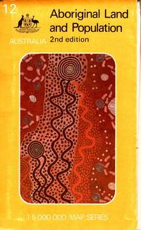
Australian Surveying and Land Information Group
Aboriginal Land and Population. Australia 1:5 000 000 map series.
Canberra: Department of Aboriginal Affairs. 1988. Large colour folding map 79 x 88 cm in original printed illustrated wraps. Some wear to edges clean very good condition. "Over 92 million hectares or about 12 per cent of the land area of Australia is held by or on behalf of Aborigines. More than two-thirds of this land is freehold the remainder being reserve leasehold or mission land. The map shows all areas of 10 hectares or more - over 4000 parcels of land - and classifies them by size and type of tenure. Also shown are the 415 centres inhabited by 50 or more Aboriginal people." 2nd Edition. Department of Aboriginal Affairs paperback
書籍販売業者の参照番号
: 105790
|
|
|
BACKELJAU F.
Carnet du géomètre-arpenteur (Société Belge de Géomètres établie à Anvers)
251pp.avec tables + 1 planche dépliante, 23cm., reliure cart. (dos en toile avec titre doré), bon état, W81268
|
|
|
Barrême, N(icolas)
L'arithmétique. Ou le livre facile pour apprendre l'arithmétique de soi-même, & sans maître.
Paris, Gandouin e.a., 1788. Kl.-8°. xvi, 491, [81] p. avec title et frontisp. in gravure sur bois et quelques figures geometrique dans la texte. Ldr. d. Zt. mit goldgepr. Rückenschild u. reicher floraler Rückenverg. Nouvelle édition, augmentée de plus 190 pages...
書籍販売業者の参照番号
: 95621BB
|
|
|
Bartoli, Cosimo
Del modo di misurare le distantie, le superficie, i corpi, le piante, le prouincie, le prospettiue, e tutte le altre cose terrene, che possono no occorrere, a gli huomini, secondo le vere regole d'Euclide, e de gli altri piu lodati scrittori.
Venedig, Per Francesco Franceschi, 1589. Kl.-4°. 143 (von 145) Bl., (3) Bl. Mit 2 gef. Tafeln and more than 145 Holzschnitte im Text. Pappband der Zeit, mit Kleisterpapierbezug. + Wichtig: Für unsere Kunden in der EU erfolgt der Versand alle 14 Tage verzollt ab Deutschland / Postbank-Konto in Deutschland vorhanden +
書籍販売業者の参照番号
: 7573CB
|
|
|
BENEDETTONI Giorgio
Pratica di agrimensura, stereometria e gnomonica nella quale si promuove l'uso di uno strumento fra tutti gli adoperati dagli agrimensori il piu semplice, ed il piu sicuro. All'ill. d. Adelmo Pignatelli de' principi di Belmonte abate olivetano, già vescovo di Bari, ora di Capua, d. G.B. monaco della medesima Congregazione.
8°, pp.XXIV-198 (2), mancano le 2 tavv. f.t. T. cart. color. coevo, dorso rinf. L'op. è divisa in 3 libri, corrispondenti ai 3 argomenti citati nel titolo. [Riccardi, I, 112: "buon trattatello di agrimensura, sebbene non si possa convenire coll'autore intorno all'eccellenza dello strumento da lui a tutti anteposto, chiamato cerchio icnografo, che consiste in un cerchio graduato fornito di ago calamitato a maniera di bussola topografica, con un'alidada a traguardi imperniata nel centro"].
|
|
|
BERTI, Giuseppe.
Quali sono i difetti dell'agricoltura del Dipartimento del Reno e quali i mezzi di toglierli?
In-4° (mm 215x150), pp. 43, (1). Brossura coeva in carta rosa. Ottimo esemplare. Interessante memoria che vinse il premio della Società Agraria del Dipartimento del Reno nell'anno 1810.  . .
|
|
|
BLANCHE V.-L.
Trigonométrie rectiligne et ses applications à l'arpentage
96pp.+ 8 planches dépliantes, 22cm., br.orig., 6e éd., bon état, W82097
|
|
|
BORDONI Antonio
TRATTATO DI GEODESIA ELEMENTARE.
In-16 gr., mz. pelle coeva, fregi e tit. oro su tassello al dorso, pp. VIII,436, con 17 tavv. in b.n. f.t. più volte ripiegate. Prima edizione di questo celebre trattato. Cfr. CLIO,I, p. 632. Lievi fioriture peraltro ben conservato.
|
|
|
BOSI Giuseppe
L'Agricoltore Italiano, giornale d'agricoltura, arti campestri, pastorizia, veterinaria, economia domestica, architettura rustica, giardinaggio, meteorologia ....1837 - 38. Segue: Varieta' agrarie o sia portafoglio campestre per il perito agrimensore pel fattore di campagna e pel proprieta' di fondi rustici....
In 16, pp. 384 ; 88. Con tre tavv. f. t. inc. all'acquaf. M. pl. coeva. Raccolta di nozioni agricole raccolte e tratte da varie altre pubblicazioni. La seconda parte sotto il titolo di varieta' risulta essere una sorta di appendice dell'agricoltore italiano stesso. Una delle tav. presenti raffigura il curioso albero dei conti Lascaris a Ventimiglia.
|
|
|
BOURGOIN P.
Encyclopedie RORET- Nouveau manuel complet d'ARPENTAGE. Art de lever les plans. Signes et formules. Géométrie. Instruments. Procédés généraux de lever les terrains. Applications des instruments et des méthodes. Bornage et formules. Orné de 256 fugures dans le texte.
P., Encyclopédie Roret, Mulo éditeur, 1923. In-12 reliure toile chagrinée éditeur, 532 pp.
|
|
|
Bryson, Thomas; Chambers, George M.
An Introduction to Mine Surveying: For Surveyors and Students of Coal Mining
288 pages. Index. Black and white diagrams and illustrations. Fold-out 3-panel plan of Newreg Colliery. Intended "to provide students of coal mining and young surveyors with an explanation of the elementary principles which are applied to the practice of mine surveying and with a description of the constructional details of the instruments in common use." - from Preface. Markings throughout. Additional information laid inside back board and affixed to back endpaper. Above-average wear. Reading copy only. Book

|
|
|
Burke, James
Connections
The author's purpose was to acquaint the reader with some of the forces that have caused change in the past, looking in particular at eight innovations: the atomic bomb, the telephone, the computer, the production-line system of manufacture, the aircraft, plastics, the guided rocket and television. Black cloth covers. Gilt title on spine. Small, point impact dent on front cover; lower back cover corner a little bumped. This book is extra heavy, and may involve extra shipping charges to some countries
|
|
|
CALZOLARI avv. Girolamo
Consultazione legale del sig. avvocato Girolamo Calzolari, bolognese, sopra la divisione de' beni esistenti in comunione specialmente fra i contadini. Opera utile ai Parrochi ed a tutte quelle persone che sono elette per arbitri nelle divisioni. Sesta edizione
In 8 pic, pp. VIII + 32. Bruniture alla brossura e a qualche pag. Br. ed. con mancanze al d. e lievi ai piatti.
|
|
|
CAMBIER, A.
Elements de Geométrie, suivis d'un traité elementaire d'arpentage et de nivellement.
Hardcover in-8, 436 pp., figures, cartonnage editeur, dos toile grise. Bon etat [NV-20]
|
|
|
CANTALUPI ANTONIO
TRATTATO COMPLETO DI AGRIMENSURA.
In-8 p., 2 volumi in 1, mz. pelle coeva (abras.), pp. 216; 264; con 12 tavv. f.t., più volte ripieg. Prima edizione. Cfr. CLIO,II,854. Qualche fiorit. e alc. postille a matita, ma complessivam. buon esempl.
|
|
|
Carben Surveying Reprints
Restoration of Lost or Obliterated Corners & Subdivision of Sections 1883-1974
Carben Surveying Reprints 1977. Hardcover. Good. Pages can have notes/highlighting. Spine may show signs of wear. ~ ThriftBooks: Read More Spend Less.Shelf and handling wear to cover and binding with general signs of previous use. Wear commensurate with age and use. Former owner's name in ink on front endpaper otherwise clean and unmarked copy. Bumping visible to corners of boards and ends of spine strip. Light scuffing and smudging across boards and spine strip. Secure packaging for safe delivery.Dust jacket quality is not guaranteed. Carben Surveying Reprints hardcover
書籍販売業者の参照番号
: 1048707687
|
|
|
Carben Surveying Reprints
Restoration of Lost or Obliterated Corners & Subdivision of Sections 1883-1974
Carben Surveying Reprints 1977. Hardcover. Good. Pages can have notes/highlighting. Spine may show signs of wear. ~ ThriftBooks: Read More Spend Less.Shelf and handling wear to cover and binding with general signs of previous use. Wear commensurate with age and use. Clean unmarked copy. Light bumping visible to corners of boards and ends of spine strip. Light scuffing and smudging to boards and spine strip. Secure packaging for safe delivery.Dust jacket quality is not guaranteed. Carben Surveying Reprints hardcover
書籍販売業者の参照番号
: 1855587955
|
|
|
Cardea Emilio
Nozioni Di Agrimensura Per Uso Degli Alunni Delle Scuole Agrarie e Degli Agricoltori
Mm 125x190 Brossura cucita di pp. 240 con 170 illustrazioni nel testo e 19 "tavole delle tangenti". legatura editoriale, leggere fioriture, piccola lacuna alla parte superiore del dorso. Opera in buone condizioni.
|
|
|
CICCOLINI Stefano
Degli agrimensori presso i Romani antichi. Ragionamento
In 8, pp. 100 + (2b). Br. rifatta. Studio dell'agrimensura nell'antica Roma. Il libro di Ciccolini 'puo' veramente dirsi opus absolutissimus, sia per la parte storica e filologica, e per la legale, sia anche per l'agraria ed economica' (Giornale Arcadico di Scienze Lettere ed Arti, vol. CXXXIV, gennaio-febbraio-marzo 1854, pp. 366-367).
|
|
|
CICCOLINI Stefano.
Degli agrimensori presso i romani antichi. Ragionamento del professore d. Stefano Ciccolini.
Roma, coi tipi della S.C. de Propaganda Fide, 1854, in-8, brossura editoriale con cornici decorative sulle copertine, pp. 100. Prima edizione di questo interessante studio sull'agrimensura nell'antica Roma. Bell'esemplare.

|
|
|
CLAUSTHAL: MINE SURVEYING
Manuscript on paper on mine surveying with 12 large & fine folding manuscript plates heightened in grey blue pink & yellow wash
40 leaves the final blank. Small folio 332 x 210 mm. orig. paste-paper boards spine & extremities somewhat worn uncut. Clausthal: ca. 1815. A fine and legible manuscript instructional manual on techniques and problems of mine surveying. The text is divided into five chapters: "Von der Vorbereitung zum Markscheiden" "On preparations for measuring the area in which mining may be carried out" "Von Bennenung der Gänge und Klüfte" "On the naming of seams and fissures" "Vom Observiren" "On Observations" "Vom Vermaß oder Verbestimmung eines Grubenfelds" "On measuring and defining a mining claim" and "Von Wasserfällen Wasserleitungen und Tiefbau" "On waterfalls water conduits and underground mining". This manuscript was probably prepared in 1815 - plate X has the entry "Markscheide 1.7.15" - at the newly founded mining school at Clausthal the famous mining town of the Harz Mountains in Lower Saxony the fine plates name mining locations in the area. The most attractive plates - all of which contain a number of figures - depict mine shafts mine surveying methods cartographical considerations techniques of prospecting and identification of mineral deposits problems of ownership rights and the constant problems of flooding. All the plates are finely drawn in black ink and have been heightened in grey blue pink and yellow wash. Internally fine. Stamp of Georg Riemschneider 1888-1946 "Oberbergrat" of Clausthal-Zellerfeld. hardcover books
書籍販売業者の参照番号
: 6396
|
|
|
Crosson, Jack
Jack's Shack : Memories from the West Coast of Vancouver Island
200 pages. Black and white illustrations. "...Follows the author's adventures on the West Coast of Vancouver Island during the 1930's. While detailed and historically accurate, this story captures the essence of day to day life in rustic and rugged surroundings." - from back cover. Prior owner's small ink stamp atop first blank leaf, otherwise clean and unmarked with light wear. A nice copy. Book

|
|
|
Curioni, G
Operazioni Topografiche
470pp + plates G/none copertina quarto tela con dorso molto consunto e con vistose abrasioni, piatti in cartone in buono stato, internamente fresco ed in condizioni piu' che buone. Le tavole che furono pubblicate in volume separato sono state rilegate insieme alla fine ma incomplete: le figg. riportate sono solo fino al no. 238..
|
|
|
Daumas
Scientific Instruments of the Seventeenth and Eighteenth Centuries and their Makers
A classic study of the development of scientific instruments emphasising the mutual dependence of theorist and craftsman. 361 pages. With References, Libraries Archives and Collections, Bibliography, and Index.
|
|
|
Davis, Raymond E
Manual of Surveying for Field and Office. In engl. Sprache. Second Edition.
New York: McGraw-Hill Book Comp. 1928. Mit 18 Taf. u. 54 Fig. i. Text. XVI, 1 Bl., 401 S. OLeinen m. Rückenvergold. 18x11 cm.
書籍販売業者の参照番号
: 32330

|
|
|
Davis, Raymond E., Francis S. Foote and W.H. Rayner
Surveying. Theory and Practice. In engl. Sprache. First Edition. Fourth Impression.
New York: McGraw-Hill Book Comp. 1928. Mit zahlr. Abb. XXIX, 1016 S. Roter OLEinenbd. m. Goldpräg. 20x13 cm.
書籍販売業者の参照番号
: 23564
|
|
|
Dawson, Llewellyn Styles
Memoirs of Hydrography: Including Brief Biographies of the Principal Officers Who Have Served in H.M. Naval Surveying Service between the Years 1750 and 1885 in Two Parts (both of Which are Included in This Single volume)
Approximately 340 pages in total. Originally printed in 1885. "Until recently the only comprehensive work on the Admiralty Hydrographic Department this book still remains one of the most important books on the history of hydrography... Particularly useful in providing information about the lesser-known hydrographers of the nineteenth century... Also includes a description of the United States coast survey. Contains a new Preface and a list of more than 80 corrections and additions compiled by researchers at the Admiralty." - from dust jacket. Usual library markings. Binding sound. Worthy reference copy. Book

|
|
|
Dosio, L.
Ai Contribuenti del Regno. SULLA FORMAZIONE DEL CATASTO GEOMETRICO IN ITALIA. Proposte sul modo di rivelamento per tutto il Regno con unicità di strumenti e metodo, giovandosi per la riproduzione per gli allegati dovuti alle provincie ed ai comuni, dei mezzi meccanici come la fotolito, la fotozincografia o fotoincisione ad un quarto ridotti, scala di 1:4000, dagli originali stabiliti per Legge nel rapporto di 1:2000 con tavole esplicative sul modo di procedere.
Legatura coeva in mezza pelle con titoli dorati sul dorso, 8vo cm12x19, pp 81 (1); due tavole litografiche ripiegate in fine, di cui una colori, con esempi di rilevamento basati sul cirocndario del torrente Nure presso Piacenza (“C. Manuelita”), disegno di una diottra azimutale ecc. Non comune.

|
|

 検索結果のメールを受信する
 PDFファイルの検索結果をダウンロード
 RSSフィード
 パーマネントリンク