|
ORTELIUS Abraham
Americae Sive Novi Orbis Nova Descripto
1612. unbound. very good. Engraving. Image measures 14" x 19" sheet measures 19" x 23". This stunning 1612 map by Abraham Ortelius depicts the Western Hemisphere. At the time it was issued the coastal areas of the New World had been fairly well explored and Europeans were just beginning settlement and colonization. It is notable for depicting Spanish and Portuguese colonies in high detail for these powers were notoriously protective of their geographical surveys. This is the first state of the third plate engraved for Ortelius's landmark map of the New World. It is distinguished from the first two plates by the lack of the bulge to the southwest coast of South America. Several other cartographic enhancements are apparent on closer inspections. Abraham Ortelius 1527--1598 a Flemish cartographer and geographer is widely regarded as one of the important and influential cartographers in history. He is known for his "Theatrum Orbis Terrarum" which was the first modern atlas. Very hard to find in black and white. unknown
Référence libraire : 286194

|
|
|
ORTELIUS Abraham 1527 1598.
Americae sive Novi orbis nova Descriptio
Amsterdam: Abraham Ortelius 1587. Original copperplate 12 4/8 x 19 inches. UNIQUE AND EXCEPTIONALLY FINE ENGRAVED COPPERPLATE of America on an oval projection with the title in an elaborate cartouche lower left and the ocean decorated with many ships and a sea-monster surrounded by a decorative border Some scratches and scuff marks old repair to top left of the cartouche. EXTREMELY RARE ORIGINAL COPPERPLATE FOR ORTELIUS'S IMPORTANT MAP OF THE AMERICAS. First issued in 1570 Ortelius's America 'was widely sold throughout Europe and had a great influence on the future cartography of the New World'. In the present copperplate the outlines of South America are considerably improved and without the bulge in Chili are much closer to those recognised today. It almost but not entirely corresponds to the third issue of the map Burden 64 which was the first to carry the cartographer's name. The small differences lie in an error to '270' degrees longitude here engraved '70' and in the historiated ornament at the corners. No antiquarian map issued from this plate is known. However the map published in the 1579 edition of Theatrum orbis terrarum contains the same error in numbering and this error was presumably copied. The use of two different plates in the printing of maps is not unusual but the differences are generally more important. We are grateful to Marcel van den Broecke for his help with this catalogue description see also his article on this copperplate published in Map Forum 2005 VII pp. 28-32. Catalogued by Kate Hunter. [Amsterdam]: Abraham Ortelius, 1587. unknown
Référence libraire : 72copperplate1
|
|
|
Ortelius Abraham
Americae Sive Novi Orbis Nova Descriptio Reprinted Engraved Antique Map
: Abraham Ortelius Original 1587 But This A Reprint 1587. 5th or later Edition . No Binding. Near Fine/No Jacket. 19" x 17. Image Size: 18 7/8" X 13 3/4". Text "Cum Privilegio Decennali Ab. Ortelius Delineab. Et Excudeb. 1587" At Lower Right. However This Must Be A Late Eighteenth Century To Twentieth Century Reprint Printed On Wove Paper Sheet Never Placed In An Atlas. Strong Impression And Color Minor Loss Of A Millimeter Depth In A Tiny Area Of Lower Left Margin Otherwise Undamaged. Margins Irregular Up To 1" Deep. Professionally Cleaned And De-Acidified With Archival Materials By A Museum-Experienced Conservator. <br/> <br/> Abraham Ortelius (Original 1587 But This A Reprint) unknown
Référence libraire : 016842

|
|
|
ORTELIUS Abraham
Americae Sive Novi Orbis Nova Descriptio
Abraham Ortelius 1612. unbound. very good. Map. Engraving with hand coloring. Image measures 14" x 19.25". This stunning 1612 map by Abraham Ortelius depicts the Western Hemisphere. At the time it was issued the coastal areas of the New World had been fairly well explored and Europeans were just beginning settlement and colonization. It is notable for depicting Spanish and Portuguese colonies in high detail for these powers were notoriously protective of their geographical surveys. This is the first state of the third plate engraved for Ortelius's landmark map of the New World. It is distinguished from the first two plates by the lack of the bulge to the southwest coast of South America. Several other cartographic enhancements are apparent on closer inspections. The Solomon Islands are depicted here for the first time since their discovery in 1568 by Alvaro de Mendana. The map identifies several places previously unpublished due to political reasons. These were provided to Ortelius by Haklyut on the basis of recent explorations. The nomenclature in California is also included. Perhaps the most notable enhancements on the east coast is the Indian name Wingandkoa and an inlet just above possibly the first depiction of the Chesapeake Bay on a printed map reflecting early English efforts at Colonization in the Outer Banks of the Carolinas. Based on Gerard Mercators 1569 World Map this map includes an abundance of cartographic speculation representing the knowledge of the region during the time. The kingdom of Quivira the supposed ancient city of gold in North America. Conquistador Francisco V�zquez de Coronado searched for Quivira for several years to finally find it was no more than American Indian settlement of farming people. Terro del Fueggo first reached by Magellan is here shown to be part of the large speculated continent of Terra Australis that extends westward with the annotation "The southern of Magellanican land as yet unknown". Other interesting annotations throughout include "Somewhere here there are islands which according to some have gold" and Patagonia shows a notation that suggests its inhabitants were giants. The waters are ornamented with illustrations of ships and a sea monster. In earlier plates the ships are different. A large title cartouche is included in the bottom left. Another scale cartouche appears in the top left. Published in the 1612 or 1608 edition the map is identical in both editions of Ortelius' famous "Theatrum Orbis Terrarum" which is historically considered the first modern atlas. Based on the text on verso only 300 copies of this particular edition were ever printed van der Broecke 11. Italian text on verso. Minor chipping to edges. Full original margins. Minor wear along original centerfold. Abraham Ortelius 1527--1598 a Flemish cartographer and geographer is widely regarded as one of the important and influential cartographers in history. He is known for his "Theatrum Orbis Terrarum" which was the first modern atlas. Abraham Ortelius unknown
Référence libraire : 219257

|
|
|
Ortelius Abraham
Andegavenium Ducatus. " Anjou Andegavensium Ditionis Vera et Integra Descriptio
Europe: Antverpiæ"/Antwerp. "ex Officiana Plantiana" . Plantijn Christoffel. 1595. Copper engraved map of Anjou after Licinio Guyeto/ Lezin Guyet 1515-80 from Ortelius' "Theatrum Orbis Terrarum" 1595 edition; black & white. Latin text to verso. Good dark impression: wormhole to lower centrefold within "MERIDIES"; tear 18mmat lower centrefold caused by guard repaired. Abraham Ortelius 1527-1598 Flemish Cartographer . produced the first modern Atlas "Theatrum Orbis Terrarum" in 1570. printed by Aegidus Coppen Diest. There were numerous editions thereafter with texts in various languages; the printing of such was taken over by Chrstoffel Plantijn in 1579 . Ortelius himself drew all the maps in manuscript before passing them to the printers. there is conjecture that he may have engraved some of the plates as well The 1595 Latin text edition is the most complete produced during his lifetime containing all the maps of the 1593 edition plus those of the the"Additamentum" and the"Pareragon" or Ancient geography. The " Additamenta" were supplements to the original Atlas; at the same time Ortelius replaced some maps with new ones showing the same place; some plates were also reworked . Ortelius was Geographer Royal To Phillip II of Spain from 1575. He also worked closely with Braun & Hogenburg on the "Civitas Orbis Terarum". After his death the plates were purchased by Jan Baptiste Vrients in 1601 who published further editions until 1612. Van de Krogt :3; .Koeman: Ort29: 25 76; van.de. Broecke:40. Europe France Anjou Andegavenium Antverpiæ"/Antwerp. "ex Officiana Plantiana" . Plantijn Christoffel. 1595 unknown
Référence libraire : 1812

|
|
|
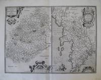
Ortelius Abraham
Angliae Scotiae et Hiberniae Sive Britannicar: Insularum Descriptio
Amsterdam: Ortelius 1575. Very good overall. A classic map of the British Isles published in the 'Theatrum Orbis Terrarum' regarded as the first modern atlas. The map was oriented with north to the right so that the map fitted the sheet of paper as it predates the convention of north to the top of the map. Ort 16 Koeman/Meurer: 6 Karrow: 1/11 van der Krogt AN: 5000:31A. Listed on Van Den Broecke as 1575L6 100 copies printed small page number 7 mm; last line centred like 3 lines above it: sem;Ponticum Virunium;Ioannem Pris�um;&Bedam. Shirley: British Isles 1477-1650 86. Latin text on verso. 19 1/2 x 13 1/2". Centerfold and right margin strengthened. Original color heightened. <br/><br/> Ortelius unknown
Référence libraire : 21270

|
|
|
ORTELIUS Abraham.
Angliae Scotiae et Hiberniae
Antwerp. c.1584-95. Size: 345 x 505 mm. Framed size: 780 x 640 mm. Copper engraving. Coloured. Fine condition good margins. A beautiful map of the British Isles north to the right. The map is based on Mercator's earlier map of the British Isles of 1564. Title in strapwork cartouche at top right text in Latin in its own cartouche at lower right scale and royal arms; ships at sea. It is difficult to put an exact date on the map because of the complex publishing history of Ortelius' atlas. Published in the Theatrum Orbis Terrarum. Moreland & Bannister p. 200-203; Van den Broecke 16. Antwerp. unknown
Référence libraire : 53076

|
|
|
Ortelius Abraham
Angliae Scotiae et Hiberniae sive Britannica Insularum Descriptio. Double-page Map of England Scotland and Ireland with Royal Crest in upper right corner. Hand-Colored by a later hand
np 1590. Image area 19 1/2 x 13 1/2 inches in 28 x 23 inch mat. Single crease down center with one 1/2 inch spot worn through otherwise a nice handsome map. Image area 19 1/2 x 13 1/2 inches in 28 x 23 inch mat. Abraham Ortelius 1527-1598 was a Flemish geographer of German origin. His major work Theatrum Orbis Terrarum 1570 with later revisions and addenda was the first modern atlas. It was based on contemporary charts and maps and contained a collection of plates engraved by Franz Hagenberg in a uniform size and format. The Theatrum preceded the first Atlas of Ortelius' good friend Gerardus Mercator. In fact popular and sentimental legend has it that Mercator delayed publication of his own work so that his younger friend's would appear first. although this simply is not true Mercator wasn't ready the legendary cartographer did compliment Ortelius for the "care and elegance" he put into his "Theatrum. unknown
Référence libraire : 37978
|
|
|
Ortelius Abraham
Aniou. " "Andegavensis Ducatus
Europe: Antwerp Joannem Bapt. Vrientium/ Vrients. 1601. Copper engraved minature map by Phillip Galle of Anjou France from" Epitome theatri Orteliani praecipuarum orbis regionum delinaetiones. . Editio ultima" Latin text to verso describing the succeeding map. . Dark impression overall toning light foxing to blank margins; one darker spot to lower blank margin The first edition of the"Epitome" in 1577 a reduced format atlas with minature maps of Abraham Ortelius's "Theatrum" is believed to have been the initiative of the engraver Phillip Galle who asked Peter Heyns to write the text. Ortelius had fled to England in 1576 having taken refuge there from Spanish oppression and may have been unaware of the plan of his two friends. The pocket atlas was a a commmercial success and was reprinted several times with Galle adding many new maps and replacing some. Jan. Baptist Vrients bought the rights and plates of the Epitome from Phillip Galle in 1601 . he published 4 editions using the Galle plates of which this is the first with Latin text. Koeman Ort58; Phillips 413; Europe France Anjou Antwerp Joannem Bapt. Vrientium/ Vrients. 1601 unknown
Référence libraire : 1513

|
|
|
Ortelius Abraham
Asiae Nova Descriptio
Antwerp 1574. Maps. Very good overall. The Middle East to Nova Guinea with part of the coast line of Australia 'Terrae Incognitae' at the extreme lower right. Based on Ortelius' own 1567 wall map of Asia from the Theatrum Orbis Terrarum. Van den Broecke Ort #6 "Occurrence in Theatrum editions and page number: 1574L3 175 copies printed large page number 11 mm last line centered like 2 lines above it: nem in maiori Tabula ante tres annos edidimus". It has the capital "F" in La Farfana and the town "Ara" is still present above Aden. A total of only 1675 of this edition were printed compared to the more common Ort 7 edition. Image size:19 3/4 x 14 3/4". With an ornate cartouche and sailing ships. Latin text on verso. Paper size: 21 x 16 1/2". Copper engraving with original hand color. A very small burn hole at the ocean south of Japan; a defect in the plate at the lower edge to the right of the cartouche creating a short black line. <br/><br/> unknown
Référence libraire : 15880

|
|
|
Ortelius Abraham
Asores Insula; Tercera; Pico; Fayala. "Açores Insulae
Europe: Antverpiæ"/Antwerp. "ex Officiana Plantiana" . Plantijn Christoffel. 1595. Copper engraved map of the islands of the Azores Portugal from Ortelius' "Theatrum Orbis Terrarum" 1595 edition; black & white. Latin text to verso. Decorative map of the most Western point of Europe the Azores belong to Portugal and as such Europe extends very far west into the Atlantic. 3 cartouches; ships & monsters to the sea. Good dark impression; tiny wormhole to lower centre fold within "MERIDES". Abraham Ortelius 1527-1598 Flemish Cartographer . produced the first modern Atlas "Theatrum Orbis Terrarum" in 1570. printed by Aegidus Coppen Diest. There were numerous editions thereafter with texts in various languages; the printing of such was taken over by Chrstoffel Plantijn in 1579 . Ortelius himself drew all the maps in manuscript before passing them to the printers. there is conjecture that he may have engraved some of the plates as well The 1595 Latin text edition is the most complete produced during his lifetime containing all the maps of the 1593 edition plus those of the the"Additamentum" and the"Pareragon" or Ancient geography. The " Additamenta" were supplements to the original Atlas; at the same time Ortelius replaced some maps with new ones showing the same place; some plates were also reworked . Ortelius was Geographer Royal To Phillip II of Spain from 1575. He also worked closely with Braun & Hogenburg on the "Civitas Orbis Terarum". After his death the plates were purchased by Jan Baptiste Vrients in 1601 who published further editions until 1612. Van de Krogt :3; .Koeman: Ort29 17595; van.de. Broecke:24. Europe Spain & Portugal Azores Asores Acores Tercera Pico fayala Antverpiæ"/Antwerp. "ex Officiana Plantiana" . Plantijn Christoffel. 1595 unknown
Référence libraire : 1778

|
|
|
ORTELIUS Abraham.
ATREBATUM REGIONIS VERA DESCRIPTIO.
Antwerp. c.1595. Copper engraving. Later colour. Fine condition good margins. Size: 48 x 36.5 cm. Splendid map of the Artois region of north eastern France from Calais to Cambrai. Magnificent strapwork title cartouche at upper right scale with strapwork decorations at lower left. The dedicatory cartouche at left identifies this plate as van den Broecke 74. Published in the famous Theatrum Orbis Terrarum by the master Flemish cartographer Abraham Ortelius. Van den BroeckeOrtelius Atlas Maps 74. Antwerp. unknown
Référence libraire : 53045

|
|
|
Ortelius Abraham
Auraicus Princ. " "AuRaicus Principatus
Europe: Antwerp Joannem Bapt. Vrientium/ Vrients. 1601. Copper engraved minature map by Phillip Galle of the Principality of Orange Southern France from" Epitome theatri Orteliani praecipuarum orbis regionum delinaetiones. . Editio ultima" Latin text to verso describing the succeeding map. . Dark impression; overall toning; light foxing/staining to blank margins; printed crooked on the page. The first edition of the"Epitome" in 1577 a reduced format atlas with minature maps of Abraham Ortelius's "Theatrum" is believed to have been the initiative of the engraver Phillip Galle who asked Peter Heyns to write the text. Ortelius had fled to England in 1576 having taken refuge there from Spanish oppression and may have been unaware of the plan of his two friends. The pocket atlas was a a commmercial success and was reprinted several times with Galle adding many new maps and replacing some. Jan. Baptist Vrients bought the rights and plates of the Epitome from Phillip Galle in 1601 . he published 4 editions using the Galle plates of which this is the first with Latin text. Koeman Ort58; Phillips 413; Europe France Orange Antwerp Joannem Bapt. Vrientium/ Vrients. 1601 unknown
Référence libraire : 1522

|
|
|
Ortelius Abraham
Austria. "
Europe: Antwerp Joannem Bapt. Vrientium/ Vrients. 1601. Copper engraved minature map by Phillip Galle of Austria from" Epitome theatri Orteliani praecipuarum orbis regionum delinaetiones. . Editio ultima" Latin text to verso describing the succeeding map. . Dark impression overall toning light foxing to blank margins. Upper margin Short7mm. The first edition of the"Epitome" in 1577 a reduced format atlas with minature maps of Abraham Ortelius's "Theatrum" is believed to have been the initiative of the engraver Phillip Galle who asked Peter Heyns to write the text. Ortelius had fled to England in 1576 having taken refuge there from Spanish oppression and may have been unaware of the plan of his two friends. The pocket atlas was a a commmercial success and was reprinted several times with Galle adding many new maps and replacing some. Jan. Baptist Vrients bought the rights and plates of the Epitome from Phillip Galle in 1601 . he published 4 editions using the Galle plates of which this is the first with Latin text. Koeman Ort58; Phillips 413; Europe Central Europe Austria Antwerp Joannem Bapt. Vrientium/ Vrients. 1601 unknown
Référence libraire : 1372

|
|
|
Ortelius Abraham:
Austriae
Antwerp 1595. Copper engraving 35.5 x 48.5 cms recent-hand-colour Latin text on verso. First published in a 1592 edition of the �Theatrum� replacing the earlier �Austriae Ducatus� plate; Wolfgang Lazius is credited as the source. Van den Broecke 106 Map unknown
Référence libraire : 7611

|
|
|
ORTELIUS Abraham 1527 1598
Austriae. Ducatus Chorographia Wolfgango Lazio Auctore.
From "Theatrum Orbis Terrarum" #34. 1573. 1st Edition. 44x 58cm folded image size 33.8x 436.5cm on watermark paper wide margins fine condition ds1. ~ From. Theatrum Orbis Terrarum References: Van den Broecke #105. First issue was 1570. This handsome map of Austria presents a distorted picture of the course of the rivers Drau Mur Gurk and Lavant with numerous spurious lakes. The rivers in the north are much more accurately represented. Oval title cartouche and scale of miles with dividers and a coat of arms adorn the sheet. This is the first state published in the first Dutch edition in 1573. . From "Theatrum Orbis Terrarum" #34. 1573. unknown
Référence libraire : 38323
|
|
|
Ortelius Abraham
Barabaria et Biledulgerid. "
Africa: Antwerp Joannem Bapt. Vrientium/ Vrients. 1601. Copper engraved minature map by Phillip Galle of the Barbary Coast North Africa with the western Mediterranean from" Epitome theatri Orteliani praecipuarum orbis regionum delinaetiones. . Editio ultima" Latin text to verso describing the succeeding map. . Dark impression overall toning light dampstaining to blank margins. Weakening and holes along the plate mark to the right caused by the printing process. Unrepaired The first edition of the"Epitome" in 1577 a reduced format atlas with minature maps of Abraham Ortelius's "Theatrum" is believed to have been the initiative of the engraver Phillip Galle who asked Peter Heyns to write the text. Ortelius had fled to England in 1576 having taken refuge there from Spanish oppression and may have been unaware of the plan of his two friends. The pocket atlas was a a commmercial success and was reprinted several times with Galle adding many new maps and replacing some. Jan. Baptist Vrients bought the rights and plates of the Epitome from Phillip Galle in 1601 . he published 4 editions using the Galle plates of which this is the first with Latin text. Koeman Ort58; Phillips 413; Africa Barbary Coast Mediterranean Antwerp Joannem Bapt. Vrientium/ Vrients. 1601 unknown
Référence libraire : 1325

|
|
|
Ortelius Abraham
Bavaria. "
Europe: Antwerp Joannem Bapt. Vrientium/ Vrients. 1601. Copper engraved minature map by Phillip Galle of Bavaria Germany from" Epitome theatri Orteliani praecipuarum orbis regionum delinaetiones. . Editio ultima" Latin text to verso describing the succeeding map. . Dark impression overall toning light foxing to blank margins. The first edition of the"Epitome" in 1577 a reduced format atlas with minature maps of Abraham Ortelius's "Theatrum" is believed to have been the initiative of the engraver Phillip Galle who asked Peter Heyns to write the text. Ortelius had fled to England in 1576 having taken refuge there from Spanish oppression and may have been unaware of the plan of his two friends. The pocket atlas was a a commmercial success and was reprinted several times with Galle adding many new maps and replacing some. Jan. Baptist Vrients bought the rights and plates of the Epitome from Phillip Galle in 1601 . he published 4 editions using the Galle plates of which this is the first with Latin text. Koeman Ort58; Phillips 413; Europe Central Europe GermanyBavaria Antwerp Joannem Bapt. Vrientium/ Vrients. 1601 unknown
Référence libraire : 1363
|
|
|
Ortelius Abraham:
Bavariae olim Vindeliciae .
Antwerp 1595. Copper engraving 38.5 x 49.5 cms recent-hand-colour Latin text on verso. First published in a 1573 edition of the �Theatrum� Philip Appian is credited as the source; Van den Broecke notes minor ornamental changes horizontal cross hatching which indicate that our map was printed from the plate in its third state. Map unknown
Référence libraire : 7610

|
|
|
Ortelius Abraham
Biturigum Regio; Limania. "Regionis Biturigum Exactiss Descriptio." & "Limaniae topographia
Europe: Antverpiæ"/Antwerp. "ex Officiana Plantiana" . Plantijn Christoffel. 1595. 2 copper engraved maps on 1 plate of Berry after Ioannem Calamaeum & Limmania region of the Auvergne after Gabriele Symeoneo from Ortelius' "Theatrum Orbis Terrarum" 1595 edition; black & white. Latin text to verso. Good dark impression. Abraham Ortelius 1527-1598 Flemish Cartographer . produced the first modern Atlas "Theatrum Orbis Terrarum" in 1570. printed by Aegidus Coppen Diest. There were numerous editions thereafter with texts in various languages; the printing of such was taken over by Chrstoffel Plantijn in 1579 . Ortelius himself drew all the maps in manuscript before passing them to the printers. there is conjecture that he may have engraved some of the plates as well The 1595 Latin text edition is the most complete produced during his lifetime containing all the maps of the 1593 edition plus those of the the"Additamentum" and the"Pareragon" or Ancient geography. The " Additamenta" were supplements to the original Atlas; at the same time Ortelius replaced some maps with new ones showing the same place; some plates were also reworked . Ortelius was Geographer Royal To Phillip II of Spain from 1575. He also worked closely with Braun & Hogenburg on the "Civitas Orbis Terarum". After his death the plates were purchased by Jan Baptiste Vrients in 1601 who published further editions until 1612. Van de Krogt :3; .Koeman: Ort29: 2410; van.de. Broecke:39ab. Europe France Berry Biturgium Limagne Limania Auvergne Antverpiæ"/Antwerp. "ex Officiana Plantiana" . Plantijn Christoffel. 1595 unknown
Référence libraire : 1811

|
|
|
Ortelius Abraham
Blesiense Territorium. "
Europe: Antwerp Joannem Bapt. Vrientium/ Vrients. 1601. Copper engraved minature map by Phillip Galle of Blois France from" Epitome theatri Orteliani praecipuarum orbis regionum delinaetiones. . Editio ultima" Latin text to verso describing the succeeding map. . Dark impression; overall toning; light foxing/staining to blank margins. The first edition of the"Epitome" in 1577 a reduced format atlas with minature maps of Abraham Ortelius's "Theatrum" is believed to have been the initiative of the engraver Phillip Galle who asked Peter Heyns to write the text. Ortelius had fled to England in 1576 having taken refuge there from Spanish oppression and may have been unaware of the plan of his two friends. The pocket atlas was a a commmercial success and was reprinted several times with Galle adding many new maps and replacing some. Jan. Baptist Vrients bought the rights and plates of the Epitome from Phillip Galle in 1601 . he published 4 editions using the Galle plates of which this is the first with Latin text. Koeman Ort58; Phillips 413; Europe France Blois Antwerp Joannem Bapt. Vrientium/ Vrients. 1601 unknown
Référence libraire : 1527

|
|
|
Ortelius Abraham
Brandenbergens. Marcha. " "Brandenburg. Marchionatus
Europe: Antwerp Joannem Bapt. Vrientium/ Vrients. 1601. Copper engraved minature map by Phillip Galle of Brandenberg Germany from" Epitome theatri Orteliani praecipuarum orbis regionum delinaetiones. . Editio ultima" Latin text to verso describing the succeeding map. . Dark impression overall toning light foxing to blank margins. The first edition of the"Epitome" in 1577 a reduced format atlas with minature maps of Abraham Ortelius's "Theatrum" is believed to have been the initiative of the engraver Phillip Galle who asked Peter Heyns to write the text. Ortelius had fled to England in 1576 having taken refuge there from Spanish oppression and may have been unaware of the plan of his two friends. The pocket atlas was a a commmercial success and was reprinted several times with Galle adding many new maps and replacing some. Jan. Baptist Vrients bought the rights and plates of the Epitome from Phillip Galle in 1601 . he published 4 editions using the Galle plates of which this is the first with Latin text. Koeman Ort58; Phillips 413; Europe Central Europe Germany Brandenberg Antwerp Joannem Bapt. Vrientium/ Vrients. 1601 unknown
Référence libraire : 1366

|
|
|
Ortelius Abraham:
Braunsvicensis et Luneburgensis dvcatvvm vera delineat. Norimberg. Agri Fidissima descrip.
Antwerp Plantin-Moretus 1595. Copper engraving 31 x 47.5 cms modern hand-colour Latin text on verso. Two maps on one sheet the Duchy of Brunswick-L�neburg and the environs of Nuremberg.Van den Broecke 99a.1/99b.2 Map unknown
Référence libraire : 8222
|
|
|
Ortelius Abraham
Brittania et Normandia; Cenomani. "Britaniae et Normandiae Typus 1594" & "Cenomanorum Galliæ regionis typus / La Mans
Europe: Antverpiæ"/Antwerp. "ex Officiana Plantiana" . Plantijn Christoffel. 1595. 2 copper engraved maps on 1 plate of Brittany & Normandy with the Le Mans area after Mattheo Ogerio from Ortelius' "Theatrum Orbis Terrarum" 1595 edition; black & white. Latin text to verso. Good dark impression. Abraham Ortelius 1527-1598 Flemish Cartographer . produced the first modern Atlas "Theatrum Orbis Terrarum" in 1570. printed by Aegidus Coppen Diest. There were numerous editions thereafter with texts in various languages; the printing of such was taken over by Chrstoffel Plantijn in 1579 . Ortelius himself drew all the maps in manuscript before passing them to the printers. there is conjecture that he may have engraved some of the plates as well The 1595 Latin text edition is the most complete produced during his lifetime containing all the maps of the 1593 edition plus those of the the"Additamentum" and the"Pareragon" or Ancient geography. The " Additamenta" were supplements to the original Atlas; at the same time Ortelius replaced some maps with new ones showing the same place; some plates were also reworked . Ortelius was Geographer Royal To Phillip II of Spain from 1575. He also worked closely with Braun & Hogenburg on the "Civitas Orbis Terarum". After his death the plates were purchased by Jan Baptiste Vrients in 1601 who published further editions until 1612. Van de Krogt :3; .Koeman: Ort29: 23127; van.de. Broecke:37ab. Europe France Brittany Brittaniae Normany Normandia Le Mans Cenomani Antverpiæ"/Antwerp. "ex Officiana Plantiana" . Plantijn Christoffel. 1595 unknown
Référence libraire : 1810
|
|
|
Ortelius Abraham
Brittannia. "
Europe: Antwerp Joannem Bapt. Vrientium/ Vrients. 1601. Copper engraved minature map by Phillip Galle of Brittany France from" Epitome theatri Orteliani praecipuarum orbis regionum delinaetiones. . Editio ultima" Latin text to verso describing the succeeding map. . Dark impression overall toning light foxing to blank margins; printed slightly crooked on page. upper margin short6-8mm. The first edition of the"Epitome" in 1577 a reduced format atlas with minature maps of Abraham Ortelius's "Theatrum" is believed to have been the initiative of the engraver Phillip Galle who asked Peter Heyns to write the text. Ortelius had fled to England in 1576 having taken refuge there from Spanish oppression and may have been unaware of the plan of his two friends. The pocket atlas was a a commmercial success and was reprinted several times with Galle adding many new maps and replacing some. Jan. Baptist Vrients bought the rights and plates of the Epitome from Phillip Galle in 1601 . he published 4 editions using the Galle plates of which this is the first with Latin text. Koeman Ort58; Phillips 413; Europe France Brittany Antwerp Joannem Bapt. Vrientium/ Vrients. 1601 unknown
Référence libraire : 1512

|
|
|
Ortelius Abraham
Buchavia vel Buchonia; Waldeccia Comitatus. "Buhaviae sive Fuldensis Ditionis Typus." & "Waldeccensis Comitatus Descriptio Accuratissima
Europe: Antverpiæ"/Antwerp. "ex Officiana Plantiana" . Plantijn Christoffel. 1595. 2 copper engraved maps on 1 plate of Buchavia or Fulda after Wolfgang Regerwyl & the Duchy of WaldeckGermany from Ortelius' "Theatrum Orbis Terrarum" 1595 edition; black & white. Latin text to verso. Good dark impression. Abraham Ortelius 1527-1598 Flemish Cartographer . produced the first modern Atlas "Theatrum Orbis Terrarum" in 1570. printed by Aegidus Coppen Diest. There were numerous editions thereafter with texts in various languages; the printing of such was taken over by Chrstoffel Plantijn in 1579 . Ortelius himself drew all the maps in manuscript before passing them to the printers. there is conjecture that he may have engraved some of the plates as well The 1595 Latin text edition is the most complete produced during his lifetime containing all the maps of the 1593 edition plus those of the the"Additamentum" and the"Pareragon" or Ancient geography. The " Additamenta" were supplements to the original Atlas; at the same time Ortelius replaced some maps with new ones showing the same place; some plates were also reworked . Ortelius was Geographer Royal To Phillip II of Spain from 1575. He also worked closely with Braun & Hogenburg on the "Civitas Orbis Terarum". After his death the plates were purchased by Jan Baptiste Vrients in 1601 who published further editions until 1612. Van de Krogt :3; .Koeman: Ort29:5687; van.de. Broecke: 98ab. Europe Central Europe Germany Buchavia Fulda Waldeck Waldeccensis Antverpiæ"/Antwerp. "ex Officiana Plantiana" . Plantijn Christoffel. 1595 unknown
Référence libraire : 1802

|
|
|
Ortelius Abraham
Burgundia Comitatus. "Burgundiae Comitatus Recentiss. Descriptio
Europe: Antverpiæ"/Antwerp. "ex Officiana Plantiana" . Plantijn Christoffel. 1595. Copper engraved map of Franche- Comte/ Burgundy from Ortelius' "Theatrum Orbis Terrarum" 1595 edition; black & white. Latin text to verso. Good dark impression; some light dampstaining to lower blank margin. Abraham Ortelius 1527-1598 Flemish Cartographer . produced the first modern Atlas "Theatrum Orbis Terrarum" in 1570. printed by Aegidus Coppen Diest. There were numerous editions thereafter with texts in various languages; the printing of such was taken over by Chrstoffel Plantijn in 1579 . Ortelius himself drew all the maps in manuscript before passing them to the printers. there is conjecture that he may have engraved some of the plates as well The 1595 Latin text edition is the most complete produced during his lifetime containing all the maps of the 1593 edition plus those of the the"Additamentum" and the"Pareragon" or Ancient geography. The " Additamenta" were supplements to the original Atlas; at the same time Ortelius replaced some maps with new ones showing the same place; some plates were also reworked . Ortelius was Geographer Royal To Phillip II of Spain from 1575. He also worked closely with Braun & Hogenburg on the "Civitas Orbis Terarum". After his death the plates were purchased by Jan Baptiste Vrients in 1601 who published further editions until 1612. Van de Krogt :3; .Koeman: Ort29: 31 146; van.de. Broecke:51. Europe France Burgundy Burgundiae Comitatus Franche-Comte Antverpiæ"/Antwerp. "ex Officiana Plantiana" . Plantijn Christoffel. 1595 unknown
Référence libraire : 1817

|
|
|
Ortelius Abraham
Burgundiae Ducatus. "
Europe: Antwerp Joannem Bapt. Vrientium/ Vrients. 1601. Copper engraved minature map by Phillip Galle of the Duchy of Burgundy France from" Epitome theatri Orteliani praecipuarum orbis regionum delinaetiones. . Editio ultima" Latin text to verso describing the succeeding map. . Dark impression; overall toning; light foxing/staining to blank margins. The first edition of the"Epitome" in 1577 a reduced format atlas with minature maps of Abraham Ortelius's "Theatrum" is believed to have been the initiative of the engraver Phillip Galle who asked Peter Heyns to write the text. Ortelius had fled to England in 1576 having taken refuge there from Spanish oppression and may have been unaware of the plan of his two friends. The pocket atlas was a a commmercial success and was reprinted several times with Galle adding many new maps and replacing some. Jan. Baptist Vrients bought the rights and plates of the Epitome from Phillip Galle in 1601 . he published 4 editions using the Galle plates of which this is the first with Latin text. Koeman Ort58; Phillips 413; Europe France Burgundy Antwerp Joannem Bapt. Vrientium/ Vrients. 1601 unknown
Référence libraire : 1519

|
|
|
Ortelius Abraham
Burgundiæ Ducatus. "Burgundiae Inferioris Quæ Ducatus Nomine Censetur Des. 1584
Europe: Antverpiæ"/Antwerp. "ex Officiana Plantiana" . Plantijn Christoffel. 1595. Copper engraved map of Lower Burgundy the Duchy from Ortelius' "Theatrum Orbis Terrarum" 1595 edition; black & white. Latin text to verso. Good dark impression; some dampstaining to lower blank margin. Abraham Ortelius 1527-1598 Flemish Cartographer . produced the first modern Atlas "Theatrum Orbis Terrarum" in 1570. printed by Aegidus Coppen Diest. There were numerous editions thereafter with texts in various languages; the printing of such was taken over by Chrstoffel Plantijn in 1579 . Ortelius himself drew all the maps in manuscript before passing them to the printers. there is conjecture that he may have engraved some of the plates as well The 1595 Latin text edition is the most complete produced during his lifetime containing all the maps of the 1593 edition plus those of the the"Additamentum" and the"Pareragon" or Ancient geography. The " Additamenta" were supplements to the original Atlas; at the same time Ortelius replaced some maps with new ones showing the same place; some plates were also reworked . Ortelius was Geographer Royal To Phillip II of Spain from 1575. He also worked closely with Braun & Hogenburg on the "Civitas Orbis Terarum". After his death the plates were purchased by Jan Baptiste Vrients in 1601 who published further editions until 1612. Van de Krogt :3; .Koeman: Ort29: 32 96; van.de. Broecke:54 Europe France Duchy of Burgundy Burgundiae Inferioris Antverpiæ"/Antwerp. "ex Officiana Plantiana" . Plantijn Christoffel. 1595 unknown
Référence libraire : 1818

|
|
|
ORTELIUS Abraham.
Caletensium et Bononiensium Ditionis Accurata Delinatio et Veromanduorum Eorumque Confinium Exactissima Discriptio. Iohanne Surhonio Auctore.
Antwerpen 1570. 2 altkolorierter Kupferkarten auf einem Blatt. 39 x 51 5 cm. Blattgr.; 33 x 23 5 cm. und 33 x 21 cm. Gr��e der Karten. Rechte Karte m. Abschabung am unteren Rand: 1 2 x 1 3 cm. Aus: "Theatrum Orbis Terrarum" v. A. Ortelius 1570. Caletensium zeigt die K�stenlinie von Greuelinge �ber Calais und von dort s�dw�rts bis Estaples. Veromanduorum zeigt eine kleine Region rund um Saint-Quentin in Nordfrankreich. Jede der Karten ist mit kleinen W�ldern und St�dten markiert und hat eine dekorative Kartusche. Antwerpen 1570. unknown
Référence libraire : 1280-17

|
|
|
Ortelius Abraham
Caletetes & Bononieinsis; Veromandui. "Caletensium et bononiensium Ditionis Accurata Delineatio." & "Veromanduorum Eorumque Confinitum Exactissima Descriptio
Europe: Antverpiæ"/Antwerp. "ex Officiana Plantiana" . Plantijn Christoffel. 1595. 2 copper engraved maps on 1 plate of Calais & Boulogne after Nicolao Nicolai delphinatus Paris 1558 & Vermandois after Johannes Surhon from Ortelius' "Theatrum Orbis Terrarum" 1595 edition; black & white. Latin text to verso. Good dark impression: wormhole to lower centrefold between the maps; show through of title from verso. Abraham Ortelius 1527-1598 Flemish Cartographer . produced the first modern Atlas "Theatrum Orbis Terrarum" in 1570. printed by Aegidus Coppen Diest. There were numerous editions thereafter with texts in various languages; the printing of such was taken over by Chrstoffel Plantijn in 1579 . Ortelius himself drew all the maps in manuscript before passing them to the printers. there is conjecture that he may have engraved some of the plates as well The 1595 Latin text edition is the most complete produced during his lifetime containing all the maps of the 1593 edition plus those of the the"Additamentum" and the"Pareragon" or Ancient geography. The " Additamenta" were supplements to the original Atlas; at the same time Ortelius replaced some maps with new ones showing the same place; some plates were also reworked . Ortelius was Geographer Royal To Phillip II of Spain from 1575. He also worked closely with Braun & Hogenburg on the "Civitas Orbis Terarum". After his death the plates were purchased by Jan Baptiste Vrients in 1601 who published further editions until 1612. Van de Krogt :3; .Koeman: Ort29: 26 139; van.de. Broecke:44ab. Europe France Calais Caletetes Boulogne Bononiensis Vermandois Veromandui Antverpiæ"/Antwerp. "ex Officiana Plantiana" . Plantijn Christoffel. 1595 unknown
Référence libraire : 1813

|
|
|
Ortelius Abraham
Caletum et Bononia. "
Europe: Antwerp Joannem Bapt. Vrientium/ Vrients. 1601. Copper engraved minature map by Phillip Galle of the Pas-de Calais France from" Epitome theatri Orteliani praecipuarum orbis regionum delinaetiones. . Editio ultima" Latin text to verso describing the succeeding map. . Dark impression; overall toning; light foxing/staining to blank margins. The first edition of the"Epitome" in 1577 a reduced format atlas with minature maps of Abraham Ortelius's "Theatrum" is believed to have been the initiative of the engraver Phillip Galle who asked Peter Heyns to write the text. Ortelius had fled to England in 1576 having taken refuge there from Spanish oppression and may have been unaware of the plan of his two friends. The pocket atlas was a a commmercial success and was reprinted several times with Galle adding many new maps and replacing some. Jan. Baptist Vrients bought the rights and plates of the Epitome from Phillip Galle in 1601 . he published 4 editions using the Galle plates of which this is the first with Latin text. Koeman Ort58; Phillips 413; Europe France Pas-de-Calais Antwerp Joannem Bapt. Vrientium/ Vrients. 1601 unknown
Référence libraire : 1532

|
|
|
Ortelius Abraham
Cambriae Typus Auctore Humfredo Lhuydo .
Antwerp 1609. The first printed map of Wales with title translated as "Map of Wales by the author Humphrey Lhuyd the Welshman from Denbigh". Based on Mercator's 1564 wall map of the British Isles and Lhuyd's manuscript map of 1568. Ornate cartouche sailing ship and sea monsters. Latin text on verso. Van den Broecke and van den Broecke-G�nzburger's Ortelius Map No. 21; 300 copies of this edition were printed. Image size: 19 1/2 x 14 1/2". Paper size: 23 x 18 3/4". Two stray printer's marks at lower margin otherwise very good. <br/><br/> unknown
Référence libraire : 15882
|
|
|
Ortelius Abraham
Campania. "
Europe: Antwerp Joannem Bapt. Vrientium/ Vrients. 1601. Copper engraved minature map by Phillip Galle of Champagne France from" Epitome theatri Orteliani praecipuarum orbis regionum delinaetiones. . Editio ultima" Latin text to verso describing the succeeding map. . Dark impression; overall toning; light foxing/staining to blank margins. The first edition of the"Epitome" in 1577 a reduced format atlas with minature maps of Abraham Ortelius's "Theatrum" is believed to have been the initiative of the engraver Phillip Galle who asked Peter Heyns to write the text. Ortelius had fled to England in 1576 having taken refuge there from Spanish oppression and may have been unaware of the plan of his two friends. The pocket atlas was a a commmercial success and was reprinted several times with Galle adding many new maps and replacing some. Jan. Baptist Vrients bought the rights and plates of the Epitome from Phillip Galle in 1601 . he published 4 editions using the Galle plates of which this is the first with Latin text. Koeman Ort58; Phillips 413; Europe France Champagne Antwerp Joannem Bapt. Vrientium/ Vrients. 1601 unknown
Référence libraire : 1525

|
|
|
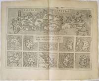
Ortelius Abraham
Candiaolim Creta; Archipelagi Insulæ Aliquot. "Arhipelagi Insularum Aliquot Descriptio
Greece: Antverpiæ"/Antwerp. "ex Officiana Plantiana" . Plantijn Christoffel. 1592-95. Copper engraved map of Crete and Islands of the Archipelago from Ortelius' "Theatrum Orbis Terrarum" 1595 edition; black & white. Latin text to verso. In the upper half of the map is Crete with the small islands of" Falconera "& "Plana"added in the top border ; below 10 small maps of : Mytilene Kythera Karpathos Naxos Santorini Milos Limnos Euboea Rhodos & Chios. Zacharakis states the the map is a variant second state between 1592 & 1595 not only the the islands in the border but also newly added are the islands of "Dionysiades Cazucaci Amarti & Caxio" and various names in the centre of the island: Messarea Cadra Carum Belveder and Casali. Good dark impression; clean and bright tiny pin prick wormhole by "Falconera". Abraham Ortelius 1527-1598 Flemish Cartographer . produced the first modern Atlas "Theatrum Orbis Terrarum" in 1570. printed by Aegidus Coppen Diest. There were numerous editions thereafter with texts in various languages; the printing of such was taken over by Chrstoffel Plantijn in 1579 . Ortelius himself drew all the maps in manuscript before passing them to the printers. there is conjecture that he may have engraved some of the plates as well The 1595 Latin text edition is the most complete produced during his lifetime containing all the maps of the 1593 edition plus those of the the"Additamentum" and the"Pareragon" or Ancient geography. The " Additamenta" were supplements to the original Atlas; at the same time Ortelius replaced some maps with new ones showing the same place; some plates were also reworked . Ortelius was Geographer Royal To Phillip II of Spain from 1575. He also worked closely with Braun & Hogenburg on the "Civitas Orbis Terarum". After his death the plates were purchased by Jan Baptiste Vrients in 1601 who published further editions until 1612. Van de Krogt :3; .Koeman: Ort29 8998 Zacherakis: 2497; van den Broecke:147a. Greece Crete Candia Archipelago Mytilene Kythera Karpathos Naxos Santorini Milos Limnos Euboea Rhodos Chios Antverpiæ"/Antwerp.. "ex Officiana Plantiana" . Plantijn Christoffel.. 1592-95 unknown
Référence libraire : 2520
|
|
|
Ortelius Abraham
Carthaginis Sinus Typus"
Africa: Antwerp Joannem Bapt. Vrientium/ Vrients. 1601. Copper engraved minature map by Phillip Galle of Tunis and the site of the ancient harbour of Carhtage. from" Epitome theatri Orteliani praecipuarum orbis regionum delinaetiones. . Editio ultima" Latin text to verso describing the succeeding map. . Dark impression overall toning light dampstaining to blank margins. The first edition of the"Epitome" in 1577 a reduced format atlas with minature maps of Abraham Ortelius's "Theatrum" is believed to have been the initiative of the engraver Phillip Galle who asked Peter Heyns to write the text. Ortelius had fled to England in 1576 having taken refuge there from Spanish oppression and may have been unaware of the plan of his two friends. The pocket atlas was a a commmercial success and was reprinted several times with Galle adding many new maps and replacing some. Jan. Baptist Vrients bought the rights and plates of the Epitome from Phillip Galle in 1601 . he published 4 editions using the Galle plates of which this is the first with Latin text. Koeman Ort58; Phillips 413; Africa Carthage/ Tunis Antwerp Joannem Bapt. Vrientium/ Vrients. 1601 unknown
Référence libraire : 1327

|
|
|
ORTELIUS Abraham.
Chinae olim Sinarum regionis nova descriptio. auctore Ludovico Georgio.
Antwerp C. Plantin 1584. . Hand-coloured double-page engraved map Latin text on verso. Dimensions: 400 × 545 mm. 15.75 × 21.5 inches. The first state of the first European printed map of China and one of the most decorative - a beautiful example. Oriented with north to the right there are cartouches for the title scale and privilege; on the map are elephants Tartar tents and land-yachts. Japan has an extra landmass to the east with its further reaches hidden by the scale cartouche. The Philippines appear but with little accuracy or detail; they were not even named until the second state c.1588. [Antwerp, C. Plantin, 1584]. unknown
Référence libraire : 86777
|
|
|
Ortelius Abraham
Corcyra vel Corfu. "
Greece.: Antwerp Joannem Bapt. Vrientium/ Vrients. 1601. Copper engraved minature map by Phillip Galle of Corfu with galleon & sea monster from" Epitome theatri Orteliani praecipuarum orbis regionum delinaetiones. . Editio ultima" Latin text to verso describing the succeeding map. . Dark impression; printed alightly crooked on the page; upper margin with heading/ title and page number short 8mm-5mm. This edition does not have a title cartouche. The first edition of the"Epitome" in 1577 a reduced format atlas with minature maps of Abraham Ortelius's "Theatrum" is believed to have been the initiative of the engraver Phillip Galle who asked Peter Heyns to write the text. Ortelius had fled to England in 1576 having taken refuge there from Spanish oppression and may have been unaware of the plan of his two friends. The pocket atlas was a a commmercial success and was reprinted several times with Galle adding many new maps and replacing some. Jan. Baptist Vrients bought the rights and plates of the Epitome from Phillip Galle in 1601; he published 4 editions using the Galle plates of which this is the first with Latin text. Zacharakis 2516/1627; Koeman Ort58; Phillips 413; Greece. Ionian Islands Corfu Kerkyra Antwerp Joannem Bapt. Vrientium/ Vrients. 1601 unknown
Référence libraire : 1306

|
|
|
Ortelius Abraham
Cosmographia das ist: Warhaffte eigentliche vnd kurtze Beschreibung dess gantzen Erdbodems nemlich Europe Asie Affrice vnd die nach Ptolomeo neuw erfundenen Inseln Americe und Magellane : so jetzt die ueuwe sic Welt genennt darinnen eines jede 1581 Leather Bound
2019. Leather Bound. New. Leather Binding on Spine and Corners with Golden Leaf Printing on round Spine. Reprinted in 2019 with the help of original edition published long back 1581. This book is printed in black & white sewing binding for longer life Printed on high quality Paper re-sized as per Current standards professionally processed without changing its contents. As these are old books we processed each page manually and make them readable but in some cases some pages which are blur or missing or black spots. If it is multi volume set then it is only single volume if you wish to order a specific or all the volumes you may contact us. We expect that you will understand our compulsion in these books. We found this book important for the readers who want to know more about our old treasure so we brought it back to the shelves. Hope you will like it and give your comments and suggestions. Lang: - ger Pages 108. EXTRA 10 DAYS APART FROM THE NORMAL SHIPPING PERIOD WILL BE REQUIRED FOR LEATHER BOUND BOOKS. FOLIO EDITION IS ALSO AVAILABLE. hardcover
Référence libraire : LB1111004701834
|
|
|
Ortelius Abraham
Cosmographia das ist: Warhaffte eigentliche vnd kurtze Beschreibung dess gantzen Erdbodems nemlich Europe Asie Affrice vnd die nach Ptolomeo neuw erfundenen Inseln Americe und Magellane : so jetzt die ueuwe sic Welt genennt darinnen eines jede 1581 Hardcover
2020. Hardcover. New. Lang: - ger Pages 108. Reprinted in 2020 with the help of original edition published long back 1581. This book is Printed in black & white Hardcover sewing binding for longer life with Matt laminated multi-Colour Dust Cover Printed on high quality Paper re-sized as per Current standards professionally processed without changing its contents. As these are old books we processed each page manually and make them readable but in some cases some pages which are blur or missing or black spots. If it is multi volume set then it is only single volume if you wish to order a specific or all the volumes you may contact us. We expect that you will understand our compulsion in these books. We found this book important for the readers who want to know more about our old treasure so we brought it back to the shelves. Any type of Customisation is possible with extra charges. Hope you will like it and give your comments and suggestions. hardcover
Référence libraire : 1111004701834
|
|
|
Ortelius Abraham
Cosmographia das ist: Warhaffte eigentliche vnd kurtze Beschreibung dess gantzen Erdbodems nemlich Europe Asie Affrice vnd die nach Ptolomeo neuw erfundenen Inseln Americe und Magellane : so jetzt die ueuwe sic Welt genennt darinnen eines jede 1581
2020. Paperback. New. Lang: - ger Pages 108. Reprinted in 2020 with the help of original edition published long back 1581. This book is Printed in black & white sewing binding for longer life with Matt laminated multi-Colour Soft Cover HARDCOVER EDITION IS ALSO AVAILABLE Printed on high quality Paper re-sized as per Current standards professionally processed without changing its contents. As these are old books we processed each page manually and make them readable but in some cases some pages which are blur or missing or black spots. If it is multi volume set then it is only single volume if you wish to order a specific or all the volumes you may contact us. We expect that you will understand our compulsion in these books. We found this book important for the readers who want to know more about our old treasure so we brought it back to the shelves. Any type of Customisation is possible with extra charges. Hope you will like it and give your comments and suggestions. paperback
Référence libraire : PB1111004701834
|
|
|
Ortelius Abraham
Creta; Sardinia; Corsica; Insula Maris Ionii. "Creta Iouis Magni medio iacet insula ponto
Greece: Antverpiæ"/Antwerp. "Apud Joannem Bapt. Vrintium" Jan Baptist Vrients. 1601. Copper engraved map of Ancient Crete from "The Parergon " of Ortelius' "Theatrum Orbis Terrarum" 1601 edition; black & white. Latin text to verso. The map shows ancient Crete in the lower half with 3 smaller maps above of Corsica the Ionian Islands & Sardinia in ancient times. Good dark impression; some soiling and spotting mainly to blank margins; light creasing to centre fold and two horizontal creases to lower blank margin; very short tears to lower edge and corners somewhat ragged. Abraham Ortelius 1527-1598 Flemish Cartographer . produced the first modern Atlas "Theatrum Orbis Terrarum" in 1570. printed by Aegidus Coppen Diest. There were numerous editions thereafter with texts in various languages; the printing of such was taken over by Chrstoffel Plantijn in 1579 . Ortelius himself drew all the maps in manuscript before passing them to the printers. there is conjecture that he may have engraved some of the plates as well The 1595 Latin text edition is the most complete produced during his lifetime containing all the maps of the 1593 edition plus those of the the"Additamentum" and the"Pareragon" or Ancient geography. The " Additamenta" were supplements to the original Atlas; at the same time Ortelius replaced some maps with new ones showing the same place; some plates were also reworked . Ortelius was Geographer Royal To Phillip II of Spain from 1575. He also worked closely with Braun & Hogenburg on the "Civitas Orbis Terarum". After his death the plates were purchased by Jan Baptiste Vrients in 1601 who published further editions until 1612. Van de Krogt :3; .Koeman: Ort34 xxix 7P; Zacherakis: 2504/1621; van den Broecke:217d. Greece Crete Ionian islands Sardinia Corsica Antverpiæ"/Antwerp.. "Apud Joannem Bapt. Vrintium" Jan Baptist Vrients. 1601 unknown
Référence libraire : 2521

|
|
|
Ortelius Abraham
Creta; Sardinia; Corsica; Insula Maris Ionii. "Creta Iouis Magni medio iacet insula ponto
Europe: Antverpiæ"/Antwerp. "ex Officiana Plantiana" . Plantijn Christoffel. 1595. Copper engraved map of Ancient Crete from "The Parergon " of Ortelius' "Theatrum Orbis Terrarum" 1595 edition; black & white. Latin text to verso. The map shows Ancient Crete in the lower half with 3 smaller maps above of Corsica the Ionian Islands & Sardina in ancient times. Good dark impression. Abraham Ortelius 1527-1598 Flemish Cartographer . produced the first modern Atlas "Theatrum Orbis Terrarum" in 1570. printed by Aegidus Coppen Diest. There were numerous editions thereafter with texts in various languages; the printing of such was taken over by Chrstoffel Plantijn in 1579 . Ortelius himself drew all the maps in manuscript before passing them to the printers. there is conjecture that he may have engraved some of the plates as well The 1595 Latin text edition is the most complete produced during his lifetime containing all the maps of the 1593 edition plus those of the the"Additamentum" and the"Pareragon" or Ancient geography. The " Additamenta" were supplements to the original Atlas; at the same time Ortelius replaced some maps with new ones showing the same place; some plates were also reworked . Ortelius was Geographer Royal To Phillip II of Spain from 1575. He also worked closely with Braun & Hogenburg on the "Civitas Orbis Terarum". After his death the plates were purchased by Jan Baptiste Vrients in 1601 who published further editions until 1612. Van de Krogt :3; .Koeman: Ort29 V 7P; Zacherakis: 2504/1621; van den Broecke:217. Europe Greece Crete Ionian islands Sardinia Corsica Antverpiæ"/Antwerp.. "ex Officiana Plantiana" . Plantijn Christoffel.. 1595 unknown
Référence libraire : 1753

|
|
|
Ortelius Abraham
Culiacana Provincia; Cuba et Spagniola; " Hispaniolae Cubae Aliarumque Insularum Circumiacente Delineato" with "Culicanae .Americae Descriptio
Americas.: Antverpiæ"/Antwerp. "ex Officiana Plantiana" . Plantijn Christoffel. 1595. Copper engraved map showing Cuba Hispaniola and the surrounding islands including the tip of Florida with above a map of Culcanea south western coast of Mexico from Ortelius' "Theatrum Orbis Terrarum" 1595 edition; black & white. Latin text to verso. Decorative cartouche ; gallion to sea. Good dark impression. Abraham Ortelius 1527-1598 Flemish Cartographer . produced the first modern Atlas "Theatrum Orbis Terrarum" in 1570. printed by Aegidus Coppen Diest. There were numerous editions thereafter with texts in various languages; the printing of such was taken over by Chrstoffel Plantijn in 1579 . Ortelius himself drew all the maps in manuscript before passing them to the printers. there is conjecture that he may have engraved some of the plates as well The 1595 Latin text edition is the most complete produced during his lifetime containing all the maps of the 1593 edition plus those of the the"Additamentum" and the"Pareragon" or Ancient geography. The " Additamenta" were supplements to the original Atlas; at the same time Ortelius replaced some maps with new ones showing the same place; some plates were also reworked . Ortelius was Geographer Royal To Phillip II of Spain from 1575. He also worked closely with Braun & Hogenburg on the "Civitas Orbis Terarum". After his death the plates were purchased by Jan Baptiste Vrients in 1601 who published further editions until 1612. Van de Krogt; 3; .Koeman:Ort29/ 8; van den Broecke:14ab. Americas. Cuba & Mexico Cuba Hispaniola Cacunae Mexico Antverpiæ"/Antwerp. "ex Officiana Plantiana" . Plantijn Christoffel. 1595 unknown
Référence libraire : 1739

|
|
|
ORTELIUS Abraham
Culiacanae Americae Regionis Descriptio / Hispaniolae Cubae Aliarumque Insularum Circumiacientium Delineatio
Antwerp: Abraham Ortelius 1587. unbound. Map. Uncolored engraving. Image measures 14" x 19.5". These two maps on one sheet detail areas of western Mexico above and the Greater Antilles below. Ortelius created them from information compiled by other mapmakers such as Mercator Guttierez and Alsons de Sata Cruz. These sources allowed him to include a wealth of detailed information that is mostly if not entirely accurate. Above the map of western Mexico shows the area around Culiacan and the Spanish settlement of Villa S. Michaels which was notable in the period for its silver mines. It begins at the Yucatan and extends through the Cayman Magnus and the Caymanes. The map below illustrates the Greater Antilles including Cuba Hispaniola Jamaica St. Jois Insula St. Johns the Bahamas Virgin Islands and the Windward Islands all in impressive detail. The section of South Florida also shows suggestion of the Florida Keys which was uncommon for these period. A notable error is that the Tropic of Cancer is labelled as the Tropic of Capricorn. A highly decorative note with strapwork and foliage fills the acific Ocean to the left of Mexico and provides information about the upper map. The lower map also has a framed cartouche with birds perched atop it. Two ship illustrations float in the choppy seas around the islands. The map is a first state from the 1587 French edition of Ortelius's "Theatrum Orbis Terrarum." It is in good condition with no chips or tears. Stain at the center seam in the lower margin not affecting the image some overall stains. French text on verso. Abraham Ortelius 1527--1598 a Flemish cartographer and geographer is widely regarded as one of the important and influential cartographers in history. He is known for his "Theatrum Orbis Terrarum" which was the first modern atlas. This map is an uncommon uncolored example of this wonderful map by Ortelius. Abraham Ortelius unknown
Référence libraire : 239611

|
|
|
Ortelius Abraham:
Daciarum Moesiarumque vetus descriptio.
Antwerp: Plantin-Moretus 1624. Copper engraving 36 x 46 cms modern hand colour Latin text on verso. Ancient Dacia and Moesia modern Romania and Bulgaria on the Black Sea. Our example was published by Balthasar Moretus at the Plantin Press in the final edition of the Parergon. Ortelius's Theatrum Orbis Terrarum is generally considered the first modern atlas of the world originally published in 1570. Ortelius gathered and selected the best available cartographic knowledge and presented it in a single volume duly credited and finely engraved in a consistent style with explanatory text. The Theatrum was very decorative and hugely popular amongst the wealthy and educated running into over forty editions in Latin and the major European languages. For Ortelius himself however his accompanying atlas of ancient geography the Parergon was a "personal work" Koeman. He seems to have regarded himself first and foremost as an antiquary and rather than copying other people's maps he drew the originals himself; they were subsequently engraved for him by the master engraver Jan Wierix. The results �have to be evaluated as the most outstanding engravings depicting the wide-spread interest in classical geography in the 16th century� Koeman. Koeman Atlantes Neerlandici Ort 46. Van den Broecke 212.2 Map Plantin-Moretus unknown
Référence libraire : 8000
|
|
|
Ortelius Abraham
Delphinatus. " "Auaicus Principatus
Europe: Antwerp Joannem Bapt. Vrientium/ Vrients. 1601. Copper engraved minature map by Phillip Galle of Duphiné France from" Epitome theatri Orteliani praecipuarum orbis regionum delinaetiones. . Editio ultima" Latin text to verso describing the succeeding map. . Dark impression; overall toning; light foxing/staining to blank margins. The first edition of the"Epitome" in 1577 a reduced format atlas with minature maps of Abraham Ortelius's "Theatrum" is believed to have been the initiative of the engraver Phillip Galle who asked Peter Heyns to write the text. Ortelius had fled to England in 1576 having taken refuge there from Spanish oppression and may have been unaware of the plan of his two friends. The pocket atlas was a a commmercial success and was reprinted several times with Galle adding many new maps and replacing some. Jan. Baptist Vrients bought the rights and plates of the Epitome from Phillip Galle in 1601 . he published 4 editions using the Galle plates of which this is the first with Latin text. Koeman Ort58; Phillips 413; Europe France Dauphine Delphinatus Antwerp Joannem Bapt. Vrientium/ Vrients. 1601 unknown
Référence libraire : 1523

|
|
|
Ortelius Abraham
Deorvm dearvmqve capita : ex antiquis numismatibus Abrahami Ortelii geographi regij collecta et historica narratione illustrata a Francisco Sweertio F. Antuerpiense 1602 Leather Bound
2019. Leather Bound. New. Leather Binding on Spine and Corners with Golden Leaf Printing on round Spine extra customization on request like complete leather Golden Screen printing in Front Color Leather Colored book etc. Reprinted in 2019 with the help of original edition published long back 1602. This book is printed in black & white sewing binding for longer life Printed on high quality Paper re-sized as per Current standards professionally processed without changing its contents. As these are old books we processed each page manually and make them readable but in some cases some pages which are blur or missing or black spots. If it is multi volume set then it is only single volume if you wish to order a specific or all the volumes you may contact us. We expect that you will understand our compulsion in these books. We found this book important for the readers who want to know more about our old treasure so we brought it back to the shelves. Hope you will like it and give your comments and suggestions. Lang: - latgre. EXTRA 10 DAYS APART FROM THE NORMAL SHIPPING PERIOD WILL BE REQUIRED FOR LEATHER BOUND BOOKS. COMPLETE LEATHER WILL COST YOU EXTRA US$ 25 APART FROM THE LEATHER BOUND BOOKS. hardcover
Référence libraire : LB1111004337090
|
|
|
Ortelius Abraham
Deorvm dearvmqve capita : ex antiquis numismatibus Abrahami Ortelii geographi regij collecta et historica narratione illustrata a Francisco Sweertio F. Antuerpiense 1602 FULL LEATHER BOUND
2019. SUPER DELUXE EDITION. New. Antique look with Golden Leaf Printing and embossing with round Spine completely handmade bindingextra customization on request like Color Leather Colored book special gold leaf printing etc. Reprinted in 2019 with the help of original edition published long back 1602. This book is printed in black & white sewing binding for longer life Printed on high quality Paper re-sized as per Current standards professionally processed without changing its contents. As these are old books we processed each page manually and make them readable but in some cases some pages which are blur or missing or black spots. If it is multi volume set then it is only single volume if you wish to order a specific or all the volumes you may contact us. We expect that you will understand our compulsion in these books. We found this book important for the readers who want to know more about our old treasure in old look so we brought it back to the shelves. Hope you will like it and give your comments and suggestions. Lang: - latgre. EXTRA 10 DAYS APART FROM THE NORMAL SHIPPING PERIOD WILL BE REQUIRED. Normal Hardbound Edition is also available on request. unknown
Référence libraire : SD1111004337090
|
|
|
Ortelius Abraham Sweerts Pierre Franc?ois
Deorvm dearvmqve capita ex antiquis numismatibus Abrahami Ortelii collecta et historica narratione illustrata a Francisco Sweertio 1602 Leather Bound
2019. Leather Bound. New. Leather Binding on Spine and Corners with Golden Leaf Printing on round Spine. Reprinted in 2019 with the help of original edition published long back 1602. This book is printed in black & white sewing binding for longer life Printed on high quality Paper re-sized as per Current standards professionally processed without changing its contents. As these are old books we processed each page manually and make them readable but in some cases some pages which are blur or missing or black spots. If it is multi volume set then it is only single volume if you wish to order a specific or all the volumes you may contact us. We expect that you will understand our compulsion in these books. We found this book important for the readers who want to know more about our old treasure so we brought it back to the shelves. Hope you will like it and give your comments and suggestions. Lang: - lat Pages 144. EXTRA 10 DAYS APART FROM THE NORMAL SHIPPING PERIOD WILL BE REQUIRED FOR LEATHER BOUND BOOKS. FOLIO EDITION IS ALSO AVAILABLE. hardcover
Référence libraire : LB1111004702359
|
|
 Recevoir par e-mail
 Télécharger en PDF
 Flux RSS


