|
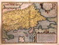
Ortelius Abraham
Histria. "
Europe: Antwerp Joannem Bapt. Vrientium/ Vrients. 1601. Copper engraved minature map by Phillip Galle of Istria from" Epitome theatri Orteliani praecipuarum orbis regionum delinaetiones. . Editio ultima" Latin text to verso describing the succeeding map. . Dark impression overall toning. Printed slightly crooked on page upper margin with heading a little short 7-9mm. The first edition of the"Epitome" in 1577 a reduced format atlas with minature maps of Abraham Ortelius's "Theatrum" is believed to have been the initiative of the engraver Phillip Galle who asked Peter Heyns to write the text. Ortelius had fled to England in 1576 having taken refuge there from Spanish oppression and may have been unaware of the plan of his two friends. The pocket atlas was a a commmercial success and was reprinted several times with Galle adding many new maps and replacing some. Jan. Baptist Vrients bought the rights and plates of the Epitome from Phillip Galle in 1601 . he published 4 editions using the Galle plates of which this is the first with Latin text. Koeman Ort58; Phillips 413; Europe Italy Istria Antwerp Joannem Bapt. Vrientium/ Vrients. 1601 unknown
Referência livreiro : 1341

|
|
|
ORTELIUS Abraham
Hollandiae Antiquorum Catthorum Sedis Nova Descriptio
Antwerp: Abraham Ortelius 1592. unbound. Map. Uncolored engraving. Sheet measures 16" x 21". This beautiful 1588 map by Abraham Ortelius depicts Holland or the Netherlands in exceptional detail. The map covers the regions near the Wadden Sea roughly covering modern day provinces of North Holland South Holland and Utrecht. The map centered on Amsterdam is oriented with north to the left. Topographical and geographical features such as mountains and cities are beautifully rendered in profile. The waters surrounding the region are shown with waves and include several illustrations of ships throughout. This is the first state of the map with later states showing a stippled sea rather than waves. Includes a large strapwork title cartouche scale of miles with a divider in the lower left. The Royal coat of arms is presented in the top left. The map also includes a 16-point compass rose. Ortelius based this map on the work of Jacob van Daventer. Published in the 1588 edition of Ortelius' famous "Theatrum Orbis Terrarum" which is historically considered the first modern atlas. Based on the text on verso only 300 copies of this particular edition were ever printed van der Broecke 79. The map is in good condition with minor wear along the original centerfold. Minor foxing at places. Original plate mark is visible. Latin text on verso. Abraham Ortelius 1527--1598 a Flemish cartographer and geographer is widely regarded as one of the important and influential cartographers in history. He is known for his "Theatrum Orbis Terrarum" which was the first modern atlas. Hard to find in black and white. Abraham Ortelius unknown
Referência livreiro : 273298

|
|
|
Ortelius Abraham
Holsatia; Wandalicæ Insulæ. "Holsatiae Descriptio."& "Rugiae Usedomiaeet Iulianae Wandalicarum insula descriptio
Europe: Antverpiæ"/Antwerp. "ex Officiana Plantiana" . Plantijn Christoffel. 1595. 2 copper engraved maps on 1 plate of Holstein after Marco Iordano Holsatio and Rugen Island Germany from Ortelius' "Theatrum Orbis Terrarum" 1595 edition; black & white. Latin text to verso. Good dark impression. Abraham Ortelius 1527-1598 Flemish Cartographer . produced the first modern Atlas "Theatrum Orbis Terrarum" in 1570. printed by Aegidus Coppen Diest. There were numerous editions thereafter with texts in various languages; the printing of such was taken over by Chrstoffel Plantijn in 1579 . Ortelius himself drew all the maps in manuscript before passing them to the printers. there is conjecture that he may have engraved some of the plates as well The 1595 Latin text edition is the most complete produced during his lifetime containing all the maps of the 1593 edition plus those of the the"Additamentum" and the"Pareragon" or Ancient geography. The " Additamenta" were supplements to the original Atlas; at the same time Ortelius replaced some maps with new ones showing the same place; some plates were also reworked . Ortelius was Geographer Royal To Phillip II of Spain from 1575. He also worked closely with Braun & Hogenburg on the "Civitas Orbis Terarum". After his death the plates were purchased by Jan Baptiste Vrients in 1601 who published further editions until 1612. Van de Krogt :3; .Koeman: Ort29:49; van.de. Broecke:87ab. Europe Central Europe Germany Holstein Holsatiae Rugen Rugiae Antverpiæ"/Antwerp. "ex Officiana Plantiana" . Plantijn Christoffel. 1595 unknown
Referência livreiro : 1795

|
|
|
ORTELIUS Abraham 1527 1598.
Indiae Orientalis Isularumque Adiacientium Typus.
Antwerp: Ortelius c 1612. Single sheet matted 13 5/8 x 19 4/8 inches to the neat line full margins showing the platemark. A striking and fine engraved map of the Indian Ocean Southeast Asia Japan and the Philippines; with a small section of the western coast of California. Featured are also the Islands of the Indian Ocean including the Northern coastline of New Guinea described as being part of the southern continent also showing Beach and other information drawn from Marco Polo. The map is decorated extensively beginning with the title in a fine strapwork cartouche lower left and armorial device upper left decorated with fine mermaids sea monsters and ships with "cum Privilegio" lower right all surrounded by a broad decorative border. From an edition of Abraham Ortelius's celebrated "Theatrum orbis terrarium." which he compiled using his many contacts in the growing network of European cartographers to secure the best existing maps. "Indiae Orientalis." is based upon Mercator's world map of 1569 which he then had re-engraved by the talented Flemish artist Frans Hogenberg 1535-90 so that it conformed to a standard format and graphic style. Abraham Ortelius first published his atlas "Theatrum orbis terrarium" in 1570 and as Rodney Shirley noted in his study of world maps ushered in an era when "pre-eminence in map publishing was transferred from Italy to the Netherlands leading to over a hundred years of Dutch supremacy in all facets of cartographical production." Ortelius was a true pioneer in map publishing and his innovations brought momentous changes to the world views of contemporary Europeans. Little is known about his training and early career but his true accomplishment was the publication of the "Theatrum". The result was an atlas that was truly without precedent. Previously collections of maps had been assembled into book form but none conformed to the modern definition of the geographical world atlas. For more information on this map or a warm welcome to see other maps and books of our collection at 72nd Street NYC please contact Natalie Zadrozna. Antwerp: Ortelius, c 1612. unknown
Referência livreiro : 72NZ129
|
|
|
ORTELIUS Abraham 1527 1598.
Indiae Orientalis Insularumque Adiacientium Typus.
Antwerp: Gielis Coppens van Diest 1570. Single sheet matted 13 5/8 x 19 4/8 inches to the neat line full margins showing the platemark. A fine engraved map with Latin text of the Indian Ocean with the title in a fine strapwork cartouche lower left and armorial device upper left decorated with fine mermaids sea monsters and ships with "cum Privilegio" lower right all surrounded by a broad decorative border minor restoration to the lower portion of the central vertical crease. First edition and a attractive copy of an early map to show India China Japan a portion of the Western coast of America including several mythical names in California and the Islands of the Indian Ocean including the Northern coastline of New Guinea described as being part of the southern continent also showing Beach and other information drawn from Marco Polo. From the first edition of Abraham Ortelius's celebrated "Theatrum orbis terrarium." which he compiled using his many contacts in the growing network of European cartographers to secure the best existing maps. "Indiae Orientalis." is based upon Mercator's world map of 1569 which he then had re-engraved by the talented Flemish artist Frans Hogenberg 1535-90 so that it conformed to a standard format and graphic style. Abraham Ortelius first published his atlas "Theatrum orbis terrarium" in 1570 and as Rodney Shirley noted in his study of world maps ushered in an era when "pre-eminence in map publishing was transferred from Italy to the Netherlands leading to over a hundred years of Dutch supremacy in all facets of cartographical production." Ortelius was a true pioneer in map publishing and his innovations brought momentous changes to the world views of contemporary Europeans. Little is known about his training and early career but his true accomplishment was the publication of the "Theatrum". The result was an atlas that was truly without precedent. Previously collections of maps had been assembled into book form but none conformed to the modern definition of the geographical world atlas. Map. [Antwerp: Gielis Coppens van Diest, 1570]. unknown
Referência livreiro : 72pac10
|
|
|
ORTELIUS Abraham
Ischia Ins
Antwerp: Philippe Galle 1595. unbound. very good. Miniature map. Uncolored engraving. Image measures 3 1/8" x 4.25". Great miniature map of Ischia off the coast of Naples detailing the volcanic landscape. From the 1595 pocket edition of Ortelius' "Theatrum Orbis Terrarum" or "Epitome" with text by Pieter Heyns. With Latin text on verso. Small tear and chip to upper right light staining to lower margin. Philippe Galle unknown
Referência livreiro : 223506

|
|
|
Ortelius Abraham:
Itala nam tellus Gaecia Maior erat
Antwerp Plantin-Moretus 1624. Copper engraving 34 x 48 cms modern hand colour Latin text on verso. First published in the 1595 edition of the �Parergon� see below this map of southern Italy depicts the ancient Greek colonies. Ortelius's �Theatrum Orbis Terrarum� is generally considered the first modern atlas of the world originally published in 1570. Ortelius gathered the best available cartographic knowledge and presented it in a consistent style in a single volume with text. The Theatrum was very decorative and hugely popular amongst the wealthy and educated running into over forty editions in Latin and the major European languages. For Ortelius himself however his atlas of ancient geography the Parergon was a "personal work" Koeman. He regarded himself as an antiquary and rather than copying other people's maps he drew the originals himself; they were subsequently engraved for him by the master engraver Jan Wierix. The results �have to be evaluated as the most outstanding engravings depicting the wide-spread interest in classical geography in the 16th century� Koeman. Koeman Atlantes Neerlandici Ort 46. Van den Broecke 210 Map unknown
Referência livreiro : 8551
|
|
|
Ortelius Abraham
Itinerarium Per Nonnullas Galliae Belgicae Partes: Der Reiseweg Durch Einige Gebiete Des Belgischen Galliens Von Abraham Ortelius Und Johannes . / European University Studie
Peter Lang Gmbh Internationaler Verlag Der Wissenschaften 2000. Paperback. New. 1st edition. 307 pages. German language. 8.20x5.90x0.80 inches. Peter Lang Gmbh, Internationaler Verlag Der Wissenschaften paperback
Referência livreiro : __3631355904 ISBN : 3631355904 9783631355909
|
|
|
Ortelius Abraham Vivianus Joannes Mercator Gerhard
Itinerarivm per nonnvllas Galliae Belgicae partes 1584 Leather Bound
2019. Leather Bound. New. Leather Binding on Spine and Corners with Golden Leaf Printing on round Spine. Reprinted in 2019 with the help of original edition published long back 1584. This book is printed in black & white sewing binding for longer life Printed on high quality Paper re-sized as per Current standards professionally processed without changing its contents. As these are old books we processed each page manually and make them readable but in some cases some pages which are blur or missing or black spots. If it is multi volume set then it is only single volume if you wish to order a specific or all the volumes you may contact us. We expect that you will understand our compulsion in these books. We found this book important for the readers who want to know more about our old treasure so we brought it back to the shelves. Hope you will like it and give your comments and suggestions. Lang: - lat Pages 93. EXTRA 10 DAYS APART FROM THE NORMAL SHIPPING PERIOD WILL BE REQUIRED FOR LEATHER BOUND BOOKS. FOLIO EDITION IS ALSO AVAILABLE. hardcover
Referência livreiro : LB1111006901853
|
|
|
Ortelius Abraham Vivianus Joannes Mercator Gerhard
Itinerarivm per nonnvllas Galliae Belgicae partes 1584
2020. Paperback. New. Lang: - lat Pages 93. Reprinted in 2020 with the help of original edition published long back 1584. This book is Printed in black & white sewing binding for longer life with Matt laminated multi-Colour Soft Cover HARDCOVER EDITION IS ALSO AVAILABLE Printed on high quality Paper re-sized as per Current standards professionally processed without changing its contents. As these are old books we processed each page manually and make them readable but in some cases some pages which are blur or missing or black spots. If it is multi volume set then it is only single volume if you wish to order a specific or all the volumes you may contact us. We expect that you will understand our compulsion in these books. We found this book important for the readers who want to know more about our old treasure so we brought it back to the shelves. Any type of Customisation is possible with extra charges. Hope you will like it and give your comments and suggestions. paperback
Referência livreiro : PB1111006901853
|
|
|
Ortelius Abraham Vivianus Joannes Mercator Gerhard
Itinerarivm per nonnvllas Galliae Belgicae partes 1584 Hardcover
2020. Hardcover. New. Lang: - lat Pages 93. Reprinted in 2020 with the help of original edition published long back 1584. This book is Printed in black & white Hardcover sewing binding for longer life with Matt laminated multi-Colour Dust Cover Printed on high quality Paper re-sized as per Current standards professionally processed without changing its contents. As these are old books we processed each page manually and make them readable but in some cases some pages which are blur or missing or black spots. If it is multi volume set then it is only single volume if you wish to order a specific or all the volumes you may contact us. We expect that you will understand our compulsion in these books. We found this book important for the readers who want to know more about our old treasure so we brought it back to the shelves. Any type of Customisation is possible with extra charges. Hope you will like it and give your comments and suggestions. hardcover
Referência livreiro : 1111006901853
|
|
|
Ortelius Abraham
La Mans Cenomanorum Typus. "
Europe: Antwerp Joannem Bapt. Vrientium/ Vrients. 1601. Copper engraved minature map by Phillip Galle of La Mans France from" Epitome theatri Orteliani praecipuarum orbis regionum delinaetiones. . Editio ultima" Latin text to verso describing the succeeding map. . Dark impression; overall toning some spots; light foxing/staining to blank margins. The first edition of the"Epitome" in 1577 a reduced format atlas with minature maps of Abraham Ortelius's "Theatrum" is believed to have been the initiative of the engraver Phillip Galle who asked Peter Heyns to write the text. Ortelius had fled to England in 1576 having taken refuge there from Spanish oppression and may have been unaware of the plan of his two friends. The pocket atlas was a a commmercial success and was reprinted several times with Galle adding many new maps and replacing some. Jan. Baptist Vrients bought the rights and plates of the Epitome from Phillip Galle in 1601 . he published 4 editions using the Galle plates of which this is the first with Latin text. Koeman Ort58; Phillips 413; Europe France Le Mans Antwerp Joannem Bapt. Vrientium/ Vrients. 1601 unknown
Referência livreiro : 1528

|
|
|
Ortelius Abraham
Languedoc. "
Europe: Antwerp Joannem Bapt. Vrientium/ Vrients. 1601. Copper engraved minature map by Phillip Galle of the Languedoc France: showing the coast from Narbonne to Marseilles from" Epitome theatri Orteliani praecipuarum orbis regionum delinaetiones. . Editio ultima" Latin text to verso describing the succeeding map. . Dark impression; overall toning; light foxing/staining to blank margins; heading miss printed as "Province" crossed out and corrected in old ink. The first edition of the"Epitome" in 1577 a reduced format atlas with minature maps of Abraham Ortelius's "Theatrum" is believed to have been the initiative of the engraver Phillip Galle who asked Peter Heyns to write the text. Ortelius had fled to England in 1576 having taken refuge there from Spanish oppression and may have been unaware of the plan of his two friends. The pocket atlas was a a commmercial success and was reprinted several times with Galle adding many new maps and replacing some. Jan. Baptist Vrients bought the rights and plates of the Epitome from Phillip Galle in 1601 . he published 4 editions using the Galle plates of which this is the first with Latin text. Koeman Ort58; Phillips 413; Europe France South of France Languadoc Antwerp Joannem Bapt. Vrientium/ Vrients. 1601 unknown
Referência livreiro : 1521

|
|
|
ORTELIUS Abraham
Larii Lacus vulgo Comensis descriptio/Territorii Romani descrip./Fori Iulii vulgo Friuli Typus
Antwerp: Abraham Ortelius 1579. unbound. very good. Map. Uncolored engraving. Image measures 13 5/16" x 19". Beautifully detailed three part map showing Lake Como Rome and its surroundings and Friuli. While the maps of Rome and Friuli are straightforward the map of Lake Como is depicted on an unraveled scroll. Ships and sea monsters dot the lake and pastoral vignettes are seen behind the scroll. Among the buildings depicted in Rome one can make out the Colliseum the Pantheon and the Basilica. Latin text on verso. From "Theatrum Orbis Terrarum". Minor aging in margins slight stain to left and center small tear to top center edge. Ink marking in top margin. Full original margins. Abraham Ortelius unknown
Referência livreiro : 215155

|
|
|
Ortelius Abraham
Latium
Antwerp: Plantin-Moretus 1624. Copper engraving 32.5 x 48 cms modern hand colour Latin text on verso. Latium the hinterland of ancient Rome. Van den Broecke notes a minor change in nomenclature which was made for the 1624 edition 209.3 which is not present here although our example was published by Balthasar Moretus at the Plantin Press in the final edition of the Parergon. Ortelius's Theatrum Orbis Terrarum is generally considered the first modern atlas of the world originally published in 1570. Ortelius gathered and selected the best available cartographic knowledge and presented it in a single volume duly credited and finely engraved in a consistent style with explanatory text. The Theatrum was very decorative and hugely popular amongst the wealthy and educated running into over forty editions in Latin and the major European languages. For Ortelius himself however his accompanying atlas of ancient geography the Parergon was a "personal work" Koeman. He seems to have regarded himself first and foremost as an antiquary and rather than copying other people's maps he drew the originals himself; they were subsequently engraved for him by the master engraver Jan Wierix. The results �have to be evaluated as the most outstanding engravings depicting the wide-spread interest in classical geography in the 16th century� Koeman. Koeman Atlantes Neerlandici Ort 46. Van den Broecke 209.2 Map Plantin-Moretus unknown
Referência livreiro : 7958
|
|
|
Ortelius Abraham
Le miroir du monde ou Epitome du theatre d'Abraham Ortelius. Auquel se represente tant par figures que par characteres la vraye situation nature et propriet� de la terre universelle. Aggrandi et enrichi entre autres de plusieurs belles cartes du P 1598 Leather Bound
2019. Leather Bound. New. Leather Binding on Spine and Corners with Golden Leaf Printing on round Spine extra customization on request like complete leather Golden Screen printing in Front Color Leather Colored book etc. Reprinted in 2019 with the help of original edition published long back 1598. This book is printed in black & white sewing binding for longer life Printed on high quality Paper re-sized as per Current standards professionally processed without changing its contents. As these are old books we processed each page manually and make them readable but in some cases some pages which are blur or missing or black spots. If it is multi volume set then it is only single volume if you wish to order a specific or all the volumes you may contact us. We expect that you will understand our compulsion in these books. We found this book important for the readers who want to know more about our old treasure so we brought it back to the shelves. Hope you will like it and give your comments and suggestions. Lang: - fre. EXTRA 10 DAYS APART FROM THE NORMAL SHIPPING PERIOD WILL BE REQUIRED FOR LEATHER BOUND BOOKS. COMPLETE LEATHER WILL COST YOU EXTRA US$ 25 APART FROM THE LEATHER BOUND BOOKS. hardcover
Referência livreiro : LB1111006341073
|
|
|
Ortelius Abraham
Le miroir du monde ou Epitome du theatre d'Abraham Ortelius. Auquel se represente tant par figures que par characteres la vraye situation nature et propriet� de la terre universelle. Aggrandi et enrichi entre autres de plusieurs belles cartes du P 1598 FULL LEATHER BOUND
2019. SUPER DELUXE EDITION. New. Antique look with Golden Leaf Printing and embossing with round Spine completely handmade bindingextra customization on request like Color Leather Colored book special gold leaf printing etc. Reprinted in 2019 with the help of original edition published long back 1598. This book is printed in black & white sewing binding for longer life Printed on high quality Paper re-sized as per Current standards professionally processed without changing its contents. As these are old books we processed each page manually and make them readable but in some cases some pages which are blur or missing or black spots. If it is multi volume set then it is only single volume if you wish to order a specific or all the volumes you may contact us. We expect that you will understand our compulsion in these books. We found this book important for the readers who want to know more about our old treasure in old look so we brought it back to the shelves. Hope you will like it and give your comments and suggestions. Lang: - fre. EXTRA 10 DAYS APART FROM THE NORMAL SHIPPING PERIOD WILL BE REQUIRED. Normal Hardbound Edition is also available on request. unknown
Referência livreiro : SD1111006341073
|
|
|
Ortelius Abraham
Le miroir du monde ou Epitome du theatre d'Abraham Ortelius. Auquel se represente tant par figures que par characteres la vraye situation nature et propriet� de la terre universelle. Aggrandi et enrichi entre autres de plusieurs belles cartes du P 1598
2019. Paperback. New. Lang: - fre. Reprinted in 2019 with the help of original edition published long back 1598. This book is Printed in black & white sewing binding for longer life with Matt laminated multi-Colour Soft Cover HARDCOVER EDITION IS ALSO AVAILABLE Printed on high quality Paper re-sized as per Current standards professionally processed without changing its contents. As these are old books we processed each page manually and make them readable but in some cases some pages which are blur or missing or black spots. If it is multi volume set then it is only single volume if you wish to order a specific or all the volumes you may contact us. We expect that you will understand our compulsion in these books. We found this book important for the readers who want to know more about our old treasure so we brought it back to the shelves. Any type of Customisation is possible with extra charges. Hope you will like it and give your comments and suggestions. paperback
Referência livreiro : PB1111006341073
|
|
|
Ortelius Abraham
Le miroir du monde ou Epitome du theatre d'Abraham Ortelius. Auquel se represente tant par figures que par characteres la vraye situation nature et propriet� de la terre universelle. Aggrandi et enrichi entre autres de plusieurs belles cartes du P 1598 Hardcover
2019. Hardcover. New. Lang: - fre. Reprinted in 2019 with the help of original edition published long back 1598. This book is Printed in black & white Hardcover sewing binding for longer life with Matt laminated multi-Colour Dust Cover Printed on high quality Paper re-sized as per Current standards professionally processed without changing its contents. As these are old books we processed each page manually and make them readable but in some cases some pages which are blur or missing or black spots. If it is multi volume set then it is only single volume if you wish to order a specific or all the volumes you may contact us. We expect that you will understand our compulsion in these books. We found this book important for the readers who want to know more about our old treasure so we brought it back to the shelves. Any type of Customisation is possible with extra charges. Hope you will like it and give your comments and suggestions. hardcover
Referência livreiro : 1111006341073
|
|
|
Ortelius Abraham
Lemovicum. "
Europe: Antwerp Joannem Bapt. Vrientium/ Vrients. 1601. Copper engraved minature map by Phillip Galle of Limoges France from" Epitome theatri Orteliani praecipuarum orbis regionum delinaetiones. . Editio ultima" Latin text to verso describing the succeeding map. . Dark impression; overall toning; light foxing/staining to blank margins. The first edition of the"Epitome" in 1577 a reduced format atlas with minature maps of Abraham Ortelius's "Theatrum" is believed to have been the initiative of the engraver Phillip Galle who asked Peter Heyns to write the text. Ortelius had fled to England in 1576 having taken refuge there from Spanish oppression and may have been unaware of the plan of his two friends. The pocket atlas was a a commmercial success and was reprinted several times with Galle adding many new maps and replacing some. Jan. Baptist Vrients bought the rights and plates of the Epitome from Phillip Galle in 1601 . he published 4 editions using the Galle plates of which this is the first with Latin text. Koeman Ort58; Phillips 413; Europe France Limoges Antwerp Joannem Bapt. Vrientium/ Vrients. 1601 unknown
Referência livreiro : 1524

|
|
|
ORTELIUS Abraham.
LEODIENSIS DIOCESIS TYPUS.
Antwerp. 1601. Copper engraving. Later colour. Fine condition Size: 48.5 x 37.5 cm. Ornate map of Luxembourg eastern Belgium and part of North Eastern France with flamboyant strapwork decoration to title across upper centre. Decorated frame. The stippling around the scale identifies this as the later of two plates of the same subject. Published in Ortelius' landmark atlas the Theatrum Orbis Terrarum. Ref: Van den Broecke 64. Antwerp. unknown
Referência livreiro : 53035

|
|
|
Ortelius Abraham
Limania. "
Europe: Antwerp Joannem Bapt. Vrientium/ Vrients. 1601. Copper engraved minature map by Phillip Galle of Limania. the area around Marignac in the Haut -Garonne of SW France France from" Epitome theatri Orteliani praecipuarum orbis regionum delinaetiones. . Editio ultima" Latin text to verso describing the succeeding map. . Dark impression ; overall toning; printed crooked on page. upper margin short4-7mm; heading shaved. The first edition of the"Epitome" in 1577 a reduced format atlas with minature maps of Abraham Ortelius's "Theatrum" is believed to have been the initiative of the engraver Phillip Galle who asked Peter Heyns to write the text. Ortelius had fled to England in 1576 having taken refuge there from Spanish oppression and may have been unaware of the plan of his two friends. The pocket atlas was a a commmercial success and was reprinted several times with Galle adding many new maps and replacing some. Jan. Baptist Vrients bought the rights and plates of the Epitome from Phillip Galle in 1601 . he published 4 editions using the Galle plates of which this is the first with Latin text. Koeman Ort58; Phillips 413; Europe France Haute- Garonne Antwerp Joannem Bapt. Vrientium/ Vrients. 1601 unknown
Referência livreiro : 1514

|
|
|
Ortelius Abraham
Lotharingiae Typus. ' "
Europe: Antwerp Joannem Bapt. Vrientium/ Vrients. 1601. Copper engraved minature map by Phillip Galle of the Lorraine France from" Epitome theatri Orteliani praecipuarum orbis regionum delinaetiones. . Editio ultima" Latin text to verso describing the succeeding map. . Dark impression; overall toning; light foxing/staining to blank margins. The first edition of the"Epitome" in 1577 a reduced format atlas with minature maps of Abraham Ortelius's "Theatrum" is believed to have been the initiative of the engraver Phillip Galle who asked Peter Heyns to write the text. Ortelius had fled to England in 1576 having taken refuge there from Spanish oppression and may have been unaware of the plan of his two friends. The pocket atlas was a a commmercial success and was reprinted several times with Galle adding many new maps and replacing some. Jan. Baptist Vrients bought the rights and plates of the Epitome from Phillip Galle in 1601 . he published 4 editions using the Galle plates of which this is the first with Latin text. Koeman Ort58; Phillips 413; Europe France Lorraine Antwerp Joannem Bapt. Vrientium/ Vrients. 1601 unknown
Referência livreiro : 1533

|
|
|
Ortelius Abraham
Lothringia. "Lorraine. Lothringiae Nova Descriptio
Europe: Antverpiæ"/Antwerp. "ex Officiana Plantiana" . Plantijn Christoffel. 1595. Copper engraved map of Lorraine from Ortelius' "Theatrum Orbis Terrarum" 1595 edition; black & white. Latin text to verso. Good dark impression; some dampstaining to lower blank margin. Abraham Ortelius 1527-1598 Flemish Cartographer . produced the first modern Atlas "Theatrum Orbis Terrarum" in 1570. printed by Aegidus Coppen Diest. There were numerous editions thereafter with texts in various languages; the printing of such was taken over by Chrstoffel Plantijn in 1579 . Ortelius himself drew all the maps in manuscript before passing them to the printers. there is conjecture that he may have engraved some of the plates as well The 1595 Latin text edition is the most complete produced during his lifetime containing all the maps of the 1593 edition plus those of the the"Additamentum" and the"Pareragon" or Ancient geography. The " Additamenta" were supplements to the original Atlas; at the same time Ortelius replaced some maps with new ones showing the same place; some plates were also reworked . Ortelius was Geographer Royal To Phillip II of Spain from 1575. He also worked closely with Braun & Hogenburg on the "Civitas Orbis Terarum". After his death the plates were purchased by Jan Baptiste Vrients in 1601 who published further editions until 1612. Van de Krogt :3; .Koeman: Ort29: 30 122; van.de. Broecke:50. Europe France Lorraine Lothringia Antverpiæ"/Antwerp. "ex Officiana Plantiana" . Plantijn Christoffel. 1595 unknown
Referência livreiro : 1816

|
|
|
Ortelius Abraham
Mansueldiæ Comitatus. "Mansfeldiae Comitatus Descriptio
Europe: Antverpiæ"/Antwerp. "ex Officiana Plantiana" . Plantijn Christoffel. 1595. Copper engraved map of Mansfeld Germany from Ortelius' "Theatrum Orbis Terrarum" 1595 edition; black & white. Latin text to verso. Good dark impression; 2 light spots at the top of the map. Abraham Ortelius 1527-1598 Flemish Cartographer . produced the first modern Atlas "Theatrum Orbis Terrarum" in 1570. printed by Aegidus Coppen Diest. There were numerous editions thereafter with texts in various languages; the printing of such was taken over by Chrstoffel Plantijn in 1579 . Ortelius himself drew all the maps in manuscript before passing them to the printers. there is conjecture that he may have engraved some of the plates as well The 1595 Latin text edition is the most complete produced during his lifetime containing all the maps of the 1593 edition plus those of the the"Additamentum" and the"Pareragon" or Ancient geography. The " Additamenta" were supplements to the original Atlas; at the same time Ortelius replaced some maps with new ones showing the same place; some plates were also reworked . Ortelius was Geographer Royal To Phillip II of Spain from 1575. He also worked closely with Braun & Hogenburg on the "Civitas Orbis Terarum". After his death the plates were purchased by Jan Baptiste Vrients in 1601 who published further editions until 1612. Van de Krogt :3; .Koeman: Ort29:53 58; van.de. Broecke: 94. Europe Central Europe Germany Mansfeld Antverpiæ"/Antwerp. "ex Officiana Plantiana" . Plantijn Christoffel. 1595 unknown
Referência livreiro : 1799

|
|
|
Ortelius Abraham
Map Guastecan Regio
Antwerp: Ortelius 1584. Map on thick paper measuring 8.75 x 7 in 22.25 x 17.75 cm in the image. Taken from the Theatrum orbis terrarum of Ortelius. One of the earliest maps of the kingdom of Huasteca or Guasteca present-day Tamaulipas originally printed on a single sheet with two other maps of Florida and Peru but here presented by itself alone. This is hand-colored with titles in Latin and ornate title cartouche. Very good. <br/><br/> Ortelius unknown
Referência livreiro : 6753
|
|
|
ORTELIUS Abraham
MAP OF POLAND Poloniae Finitimarumque Locorum Descriptio Auctore Wenceslao Godreccio Polono plate 86
Antwerp: Abraham Ortelius 1587. Early map of Poland Lithuania parts of Belarus and the Ukraine. Plate no 86 to the verso with FRENCH TEXT. 42x 51 cms 16.5 x 20 inches. HAND-COLOURED Finely hand coloured in wash and outline. Decorated with a title cartouche a sailing ship. Scarce item. Two short plate cracks to the left and lower margins. Small lower fold split neatly secured. PLEASE EMAIL FOR PHOTOS. French Edition. Hardback. V.g. Abraham Ortelius Hardcover
Referência livreiro : Map892
|
|
|
ORTELIUS Abraham
MAP OF HELVETIAE SWITZERLAND plate 62 French Text
Antwerp: Abraham Ortelius 1587. Early map of SWITZERLAND. No 62 and FRENCH TEXT TO VERSO. 38x 51 cms 15.5 x 20 inches. Lower blank margin cropped but leaving margin below the plate mark. HAND-COLOURED Finely hand coloured in wash and outline. Decorated with a title cartouche. Scarce item. PLEASE EMAIL FOR PHOTOS. French Edition. Hardback. V.g. Abraham Ortelius Hardcover
Referência livreiro : Map906
|
|
|
ORTELIUS Abraham
Maris Pacifici
Antwerp 1595. quod vulgo Mar del Zur 1595. Double-page engraved map. The Maris Pacifici map was first issued in 1590. It is based upon Gerard Mercator's world map of 1569 with details from 25 Portuguese manuscript maps of Bartolomeo de Lasso which Plancius obtained and later used for his own world map. Ortelius shows the Moluccas and the Philippines already the site of considerable Dutch activity and a misshapen Japan. An odd ‘Isla de Plata’ appears above Japan. Guam ’Isla de Ladrones’ is shown. New Guinea appears very different to Ortelius' world map of 1588 suggesting he may have drawn additional information from an unrecorded voyage. Among other notable features it is detached from Terra Australis. The Solomons or Melanesia are located as are some of the islands of Micronesia. This was the first map to focus on the Pacific Ocean. The map reflects a much smaller body of water than the true size of the Pacific. The treatment of America and most notably the Northwest Coast is reminiscent of Hondius' America. This map and the Hondius and Le Clerc rare map of 1589 known only in the 1602 edition have a curious and not fully understood relationship as to which is truly the first map of the Pacific although because no example of the 1589 Hondius-Le Clerc has been discovered this map retains primacy. Ortelius' ‘Theatrum Orbis Terrarum’ is widely regarded as the first modern atlas. At the time of its publication it was the most expensive book ever produced. Between 1570 and 1612 it was issued in 31 editions and seven languages. The present example is the first state of the map appearing in the 1595 Latin edition. Van den Broecke 12.1; Burden 74: van der Krogt 0600:31 from van der Krogt 31:051. unknown
Referência livreiro : 12905

|
|
|
ORTELIUS Abraham 1527 1598.
Maris Pacifici quod vulgo Mar del Zur cum regionaribus circumiacentibus insulisque in eodem passim sparsis novissima descripto.
Antwerp: Jan Baptist Vrients 1603. Single sheet 17 � x 23 � inches. EXCEPTIONALLY FINE engraved map of the Pacific Ocean the title in an elaborate mannerist strapwork and allegorical cartouche upper right and the imprint in the lower left the ocean decorated with ships all with hand-color in full evenly browned two older tape repairs to verso one or two pale stains. THE FIRST PRINTED MAP TO BE DEVOTED TO THE PACIFIC OCEAN AND TO SHOW AN EARLY DEPICTION OF THE WEST COAST OF AMERICA. 1603 Latin edition first published in 1570. Van den Broecke estimates this edition to have been printed in a run of 300 copies only. This map from the 1603 Antwerp edition with text in Latin on the verso was one of the most important that appeared in Abraham Ortelius's "Theatrum orbis terrarium." Entitled "Maris Pacifici" - "Ocean of Tranquility" - it was the first printed map to be devoted to the Pacific Ocean and also includes an early depiction of the west coast of North America Japan and New Guinea. Nova Hispania Mexico and the California peninsula are shown quite accurately for the time. Primarily however the map celebrates the achievements of Magellan the first to traverse the Pacific Ocean and to discover the strait at the southern tip of South America that would come to be named in his honor. Magellan's ship "Victoria" is depicted in the Pacific along with a celebratory Latin inscription. The map is unusually centered on the Pacific itself rather than on any landmass thus showing the ocean in its entirety as it stretches from Asia to America. This deceptively simple compositional strategy emphasizes the vastness of the Pacific while stressing the magnitude of Magellan's achievement as the first to circumnavigate the globe. Ortelius derived much of the Pacific cartography from the map published in 1589 by his associate the map engraver Frans Hogenberg though Ortelius introduced a considerably narrower and more correct North America at the latitude of the Tropic of Cancer than Hogenberg. Although the plate bears the date of 1589 "Maris Pacifici" was first published in Ortelius's 1590 "Additamentum" an appendix to his atlas and was then included in future editions of the "Theatrum." Ortelius "was very bold to attempt to map what was perhaps the least-known part of the world. He must have realized however that the Pacific was increasing in stature as a commercial route to Asia. The long-hoped-for northwest passage had not been found and mariners avoided the Portuguese-controlled South African voyage to Asia. The ocean became the focus of much sixteenth century exploration. "The symbol of that exploration was Ferdinand Magellan's ship Victoria; on the map it is at sea having just passed through the strait that bears his name. Magellan became the first European mariner to sail from the Atlantic Ocean to the Pacific and his voyage revealed much about the Pacific Ocean�more was known about the west coast of America and the Pacific after Sir Francis Drake's circumnavigation 1577-1580 when he explored America's west coast and named it New Albion. Ortelius followed Drake's voyage with keen interest corresponded with Gerard Mercator about it and incorporated as much as he could from Drake's discoveries onto 'Maris Pacifici' - the Gulf of California takes on an entirely new shape and the Rio Grande is introduced for the first time on a printed map� "Along the lower part of the map is 'Terra Australia' not an early form of Australia but a large phantom continent that the early mapmakers believed balanced the weight of Europe and Asia. When Magellan sailed around South America he believed he was following the coastline of the northern tip of Terra Australis. Like other sixteenth-century map-makers Ortelius incorporated this enormous continent into his map of the Pacific Ocean" Cohen. Van den Broecke Ort12. Antwerp: Jan Baptist Vrients, 1603. unknown
Referência livreiro : 72MMS219

|
|
|
Ortelius Abraham
Maris Pacifici quod volg� Mar del Zur cum regionibus circumiacentibus insulisque in eodem passim sparsis novissima descriptio
Antwerp. Very Good. 1589. First. Map. Although the map was prepared in 1589 its first appearance in an Ortelius atlas Theatrum Orbis Terrarum was in 1590. Image 17 1/4 x 13 1/2; paper 19 7/16 x 21 15/16; frame 25 x 31inches. First state with Latin text on verso. Closed separation to head & tail of fold. ; Folio ; Please note this will require additional postage.; All shipments through USPS insured Priority Mail. . unknown
Referência livreiro : 990

|
|
|
Ortelius Abraham
Mediolanansis Ducatus. "Ducatus Medialanensis
Europe: Antverpiæ"/Antwerp. "ex Officiana Plantiana" . Plantijn Christoffel. 1595. Copper engraved map of the Duchy of Milan after Johannes Georgio Septalmediollanses from Ortelius' "Theatrum Orbis Terrarum" 1595 edition; black & white. Latin text to verso. Ships and monsters decorate the sea. Good dark impression. Abraham Ortelius 1527-1598 Flemish Cartographer . produced the first modern Atlas "Theatrum Orbis Terrarum" in 1570. printed by Aegidus Coppen Diest. There were numerous editions thereafter with texts in various languages; the printing of such was taken over by Chrstoffel Plantijn in 1579 . Ortelius himself drew all the maps in manuscript before passing them to the printers. there is conjecture that he may have engraved some of the plates as well The 1595 Latin text edition is the most complete produced during his lifetime containing all the maps of the 1593 edition plus those of the the"Additamentum" and the"Pareragon" or Ancient geography. The " Additamenta" were supplements to the original Atlas; at the same time Ortelius replaced some maps with new ones showing the same place; some plates were also reworked . Ortelius was Geographer Royal To Phillip II of Spain from 1575. He also worked closely with Braun & Hogenburg on the "Civitas Orbis Terarum". After his death the plates were purchased by Jan Baptiste Vrients in 1601 who published further editions until 1612. Van de Krogt :3; .Koeman: Ort29 :74 33;van den Broecke:125. Europe Italy Milan Mediolanum Mediolanensis Antverpiæ"/Antwerp.. "ex Officiana Plantiana" . Plantijn Christoffel.. 1595 unknown
Referência livreiro : 1761

|
|
|
ORTELIUS Abraham.
Namurcum Comitatus.
Antwerp. c1602. Size: 400x 525 mm Copperplate engraving with original colour. Good condition. A striking and very handsome map of the province of Namur in modern day Belgium. This map was first used by Ortelius in 1579 and it is based on the earlier map by I. Surhon. The map features a pair of stylish title cartouches and a directional compass. Namur is a province in Wallonia in the French speaking part of Belgium. The city stands astride the twin rivers of the Sambre and the Meuse. Published in Ortelius' landmark atlas the Theatrum Orbis Terrarum. Antwerp. unknown
Referência livreiro : 69318

|
|
|
ORTELIUS Abraham
Namurcum Comitatus
Antwerp: Ortelius Abraham 1601. unbound. very good. Map. Engraving with hand coloring. Image measures 15.5" x 20.25". Lovely map of the Namur region of Belgium. Includes a compass rose and a cartouche incorporating the Belgian coat of arms. From the 1601 Latin edition of Ortelius' "Theatrum Orbis Terrarum" the first modern Atlas. Margins have been cropped some chipping and tears along margins. Stain to top center margin and also to lower left and right of image. Ortelius, Abraham unknown
Referência livreiro : 208175

|
|
|
Ortelius Abraham:
Natoliae quae olim Asia Minor nova descriptio / Aegypti recentior descriptio / Carthaginis celeberrimi sinus typus.
Antwerp Plantin-Moretus 1595. Copper engraving 32 x 49 cms three maps on one sheet: Anatolia or modern Turkey Egypt Tunis and ancient Carthage; modern hand colour conjugate wormhole at centrefold Latin text on verso. An engraved historical note on the map of Carthage indicates that nearby Tunis which is the focus of the map was captured for Christendom by the Holy Roman Emperor and King of Spain Charles V in 1535. A version of the truth perhaps as Charles reinstated the deposed Hafsid Sultan but a Spanish governor resided at Goletta for a generation. The map was first published in 1570 just after the city had fallen into Ottoman hands and although it was briefly recaptured Tunis had been Ottoman for 20 years by the time our example of the map was published. Van den Broecke 174.2 Map unknown
Referência livreiro : 8572
|
|
|
ORTELIUS Abraham.
Natoliae quae olim Asia Minor Nova Descriptio - Aegypti Recentior Descriptio - Carthaginis Celeberrimi Sinus Typus.
Antwerpen 1573. 3 altkolor. Kupferkarten auf einem Blatt. 33 x 49 cm. Bildausschn. Bugfalte. In gutem Zustand. 3 alotkolor. Karten von einer Kupferplatte gedruckt zeigen das Gebiet der T�rkei mit Zypern Kreta Rhodos. Auf den beiden anderen Karten: �gypten und Tunis. Beschreibender Text in deutscher Sprache a. d. R�cks. [Antwerpen 1573]. unknown
Referência livreiro : 1761-12

|
|
|
ORTELIUS Abraham.
Nobilis Hannoniae comitatus descrip.
Antwerp. 1579. Copper engraving. Original colour. Good condition. Some wear to lower centrefold. Narrow margins a little darkened Size: 49 x 37 cm. Based on the 1548 map by Jacques & Jean Surhonio which for security reasons was never published. Only in 1579 when Antwerp was independent for a short time did Ortelius publish it van den Broecke 70. Strapwork cartouche coats of arms two scales. Published in the wonderful Theatrum Orbis Terrarum. Van den Broecke 70 Antwerp. unknown
Referência livreiro : 52409

|
|
|
ORTELIUS Abraham.
Nobilis Hannoniae Comitatus Descrip.
Antwerp. c1572. Copper engraving. Original colour. Fine condition good margins. Size: 50 x 38 cm. Ortelius published this map in his now famous atlas The Theatrum Orbis Terrarum basing it on the earlier 1548 map by Jacques and Jean Surhon according to the reference book of van der Broecke there were only one hundred copies of this map printed. Strapwork cartouche coats of armstwo scales beadwork border. This is a highly decorative inexpensive sixteenth century map. van den Broecke 69 Antwerp. unknown
Referência livreiro : 52379

|
|
|
Ortelius Abraham
Nortgoiavel Bavariae Palitanatus; Argeninense Territorium. "Palitanatus Bavariae Descriptio." & "Argentoratensis Agri Descriptio
Europe: Antverpiæ"/Antwerp. "ex Officiana Plantiana" . Plantijn Christoffel. 1595. 2 copper engraved maps on 1 plate of Imperial Bavaria after Erhardo Reych & Strassburg from Ortelius' "Theatrum Orbis Terrarum" 1595 edition; black & white. Latin text to verso. Good dark impression; dampstaining to lower blank margin. Abraham Ortelius 1527-1598 Flemish Cartographer . produced the first modern Atlas "Theatrum Orbis Terrarum" in 1570. printed by Aegidus Coppen Diest. There were numerous editions thereafter with texts in various languages; the printing of such was taken over by Chrstoffel Plantijn in 1579 . Ortelius himself drew all the maps in manuscript before passing them to the printers. there is conjecture that he may have engraved some of the plates as well The 1595 Latin text edition is the most complete produced during his lifetime containing all the maps of the 1593 edition plus those of the the"Additamentum" and the"Pareragon" or Ancient geography. The " Additamenta" were supplements to the original Atlas; at the same time Ortelius replaced some maps with new ones showing the same place; some plates were also reworked . Ortelius was Geographer Royal To Phillip II of Spain from 1575. He also worked closely with Braun & Hogenburg on the "Civitas Orbis Terarum". After his death the plates were purchased by Jan Baptiste Vrients in 1601 who published further editions until 1612. Van de Krogt :3; .Koeman: Ort29: 6694; van.de. Broecke: 112ab. Europe Central Europe Germany Bavaria Palitenatus Bavariae France Strassburg Argentoratensis Antverpiæ"/Antwerp. "ex Officiana Plantiana" . Plantijn Christoffel. 1595 unknown
Referência livreiro : 1804

|
|
|
Ortelius Abraham
Nova Hispania "Hispaniae Novae sive Magnae Recens et Vera decritio 1579
Americas.: Antverpiæ"/Antwerp. "ex Officiana Plantiana" . Plantijn Christoffel. 1595. Copper engraved map of Nova Hispania ; South West Mexico from Ortelius' "Theatrum Orbis Terrarum" 1595 edition; black & white. Latin text to verso. 2 decorative cartouches ; gallions to sea. Good dark impression; wormhole 3mm to lower centre fold; another to upper blank margin; minor lifting of paper /fault upper plate close to "Septemtrio" minor loss to plate. Abraham Ortelius 1527-1598 Flemish Cartographer . produced the first modern Atlas "Theatrum Orbis Terrarum" in 1570. printed by Aegidus Coppen Diest. There were numerous editions thereafter with texts in various languages; the printing of such was taken over by Chrstoffel Plantijn in 1579 . Ortelius himself drew all the maps in manuscript before passing them to the printers. there is conjecture that he may have engraved some of the plates as well The 1595 Latin text edition is the most complete produced during his lifetime containing all the maps of the 1593 edition plus those of the the"Additamentum" and the"Pareragon" or Ancient geography. The " Additamenta" were supplements to the original Atlas; at the same time Ortelius replaced some maps with new ones showing the same place; some plates were also reworked . Ortelius was Geographer Royal To Phillip II of Spain from 1575. He also worked closely with Braun & Hogenburg on the "Civitas Orbis Terarum". After his death the plates were purchased by Jan Baptiste Vrients in 1601 who published further editions until 1612. Van de Krogt :3; .Koeman: Ort29/ 7; van den Broecke:13. Americas. Nova Hispania Mexico New Spain Antverpiæ"/Antwerp. "ex Officiana Plantiana" . Plantijn Christoffel. 1595 unknown
Referência livreiro : 1738

|
|
|
ORTELIUS Abraham
OPAKH. Thraciae Veteris Typus
Antwerp: Abraham Ortelius 1592. unbound. Map. Engraving with hand color. Image measures 14" x 18 3/4". This beautiful 1592 map by Abraham Ortelius depicts the Balkan Peninsula or the Balkans extending from The Sea of Marmara Istanbul and the Bosporus Strait westward to Macedonia including Bulgaria. Portions of the Black Sea and the Thrakikon Pelagos are also shown. Topographical and geographical features such as mountains forests and cities are beautifully rendered in profile. Ortelius based this map on the 1560 South-East Europe map by Gastaldi and on on information from numerous ancient sources specifically Herodotus Plinius Strabo Appianus Virgilius Plutarchus and Sidonius. A beautifully engraved title cartouche adorns the top left of the map. Two additional cartouches containing text are also included in the top and bottom right. This map was published in the 1592 edition of Ortelius's famous "Theatrum Orbis Terrarum" which is historically considered the first modern atlas. Based on the Latin text on verso only 525 copies of this particular atlas were ever printed van der Broecke 214. The map is in good condition with minor wear and toning along the original centerfold. Light stain in lower left margin. Minor foxing with Latin text on verso. Abraham Ortelius 1527--1598 a Flemish cartographer and geographer is widely regarded as one of the important and influential cartographers in history. He is known for his "Theatrum Orbis Terrarum" which was the first modern atlas. Van den Broecke #214 Abraham Ortelius unknown
Referência livreiro : 272534
|
|
|
Ortelius Abraham:
Palatinatus Bavariae
Antwerp 1601. Copper engraving recent hand-colour French text on verso. From the series of maps engraved by the Arsenius brothers Ambrose and Ferdinand for the third epitome of the Theatrum. Map unknown
Referência livreiro : 5805

|
|
|
Ortelius Abraham
Palitinatus Bavariæ. "
Europe: Antwerp Joannem Bapt. Vrientium/ Vrients. 1601. Copper engraved minature map by Phillip Galle of Palitanutus Bavaria. Germany showing the course of the Danube through Straubing Regensberg &c. from" Epitome theatri Orteliani praecipuarum orbis regionum delinaetiones. . Editio ultima" Latin text to verso describing the succeeding map. . Dark impression overall toning light foxing to blank margins. The first edition of the"Epitome" in 1577 a reduced format atlas with minature maps of Abraham Ortelius's "Theatrum" is believed to have been the initiative of the engraver Phillip Galle who asked Peter Heyns to write the text. Ortelius had fled to England in 1576 having taken refuge there from Spanish oppression and may have been unaware of the plan of his two friends. The pocket atlas was a a commmercial success and was reprinted several times with Galle adding many new maps and replacing some. Jan. Baptist Vrients bought the rights and plates of the Epitome from Phillip Galle in 1601 . he published 4 editions using the Galle plates of which this is the first with Latin text. Koeman Ort58; Phillips 413; Europe Central Europe Germany Bavaria Antwerp Joannem Bapt. Vrientium/ Vrients. 1601 unknown
Referência livreiro : 1362

|
|
|
Ortelius Abraham
Pannonaie et Illyrici Veteris Tabula
Antwerp: Plantin-Moretus 1624. Copper engraving 36 x 46 cms modern hand colour Latin text on verso. The Dalmatian coast in antiquity. Our example was published by Balthasar Moretus at the Plantin Press in the final edition of the Parergon. Ortelius's Theatrum Orbis Terrarum is generally considered the first modern atlas of the world originally published in 1570. Ortelius gathered and selected the best available cartographic knowledge and presented it in a single volume duly credited and finely engraved in a consistent style with explanatory text. The Theatrum was very decorative and hugely popular amongst the wealthy and educated running into over forty editions in Latin and the major European languages. For Ortelius himself however his accompanying atlas of ancient geography the Parergon was a "personal work" Koeman. He seems to have regarded himself first and foremost as an antiquary and rather than copying other people's maps he drew the originals himself; they were subsequently engraved for him by the master engraver Jan Wierix. The results �have to be evaluated as the most outstanding engravings depicting the wide-spread interest in classical geography in the 16th century� Koeman. Koeman Atlantes Neerlandici Ort 46. Van den Broecke 203.1 Map Plantin-Moretus unknown
Referência livreiro : 7957
|
|
|
Ortelius Abraham
Pedemontana Regio. "Pedemontanae Vicinorumque Regionum auctore Iacobo Castado descrip
Europe: Antverpiæ"/Antwerp. "ex Officiana Plantiana" . Plantijn Christoffel. 1595. Copper engraved map of Piedmont from Ortelius' "Theatrum Orbis Terrarum" 1595 edition; black & white. Latin text to verso. The map of shows the extent of Piedmont from the Alps in the North West and the coast from Monacco to beyond Genoa to Codemonte below the Appenines.; it also clearly shows the catchment area of the river Po. Good dark impression; crack in the plate at lower edge at longitude 29; centrefold split repaired and light stain to lower margin. Abraham Ortelius 1527-1598 Flemish Cartographer . produced the first modern Atlas "Theatrum Orbis Terrarum" in 1570. printed by Aegidus Coppen Diest. There were numerous editions thereafter with texts in various languages; the printing of such was taken over by Chrstoffel Plantijn in 1579 . Ortelius himself drew all the maps in manuscript before passing them to the printers. there is conjecture that he may have engraved some of the plates as well The 1595 Latin text edition is the most complete produced during his lifetime containing all the maps of the 1593 edition plus those of the the"Additamentum" and the"Pareragon" or Ancient geography. The " Additamenta" were supplements to the original Atlas; at the same time Ortelius replaced some maps with new ones showing the same place; some plates were also reworked . Ortelius was Geographer Royal To Phillip II of Spain from 1575. He also worked closely with Braun & Hogenburg on the "Civitas Orbis Terarum". After his death the plates were purchased by Jan Baptiste Vrients in 1601 who published further editions until 1612. Van de Krogt :3; .Koeman: Ort29 :77 34.van den Broecke:128 Europe Italy Piedmont. Antverpiæ"/Antwerp.. "ex Officiana Plantiana" . Plantijn Christoffel.. 1595 unknown
Referência livreiro : 1765

|
|
|
Ortelius Abraham
Pedmontana Reg. " "Pedemontium
Europe: Antwerp Joannem Bapt. Vrientium/ Vrients. 1601. Copper engraved minature map by Phillip Galle of Piedmont from" Epitome theatri Orteliani praecipuarum orbis regionum delinaetiones. . Editio ultima" Latin text to verso describing the succeeding map. . Dark impression overall toning. The first edition of the"Epitome" in 1577 a reduced format atlas with minature maps of Abraham Ortelius's "Theatrum" is believed to have been the initiative of the engraver Phillip Galle who asked Peter Heyns to write the text. Ortelius had fled to England in 1576 having taken refuge there from Spanish oppression and may have been unaware of the plan of his two friends. The pocket atlas was a a commmercial success and was reprinted several times with Galle adding many new maps and replacing some. Jan. Baptist Vrients bought the rights and plates of the Epitome from Phillip Galle in 1601 . he published 4 editions using the Galle plates of which this is the first with Latin text. Koeman Ort58; Phillips 413; Europe Italy Piedmont Antwerp Joannem Bapt. Vrientium/ Vrients. 1601 unknown
Referência livreiro : 1336

|
|
|
ORTELIUS Abraham
Percici sive Sophorum Regni Tipus
Venice: Giovanni Turrini 1655. unbound. very good. Miniature map. Uncolored engraving. Image measures 2 7/8" x 4". 1655. This miniature map of Persia belongs to a period of great cartographic interest in the early-to-mid 17th century. Conscious of the great popularity of Abraham Ortelius's miniature atlas which the famous cartographer first published in 1577 Giovanni Turrini produced a now-rare Italian version of the atlas "Il Teatro del Mondo" in which this map was included. It includes the region between the Caspian Sea in the north and the Persian Gulf and Arabian Sea in the south. Cities are labeled and rivers and forts are drawn with great care. The map is in very good condition with no chips or tears and light staining to edges. Foredges inked in red and Italian text on verso. Giovanni Turrini was an Italian publisher based in Venice. Scarce. Giovanni Turrini unknown
Referência livreiro : 216782

|
|
|
Ortelius Abraham
Persiæ Regnum sive Sophorum Imperium. "Persici sive Soporum Regni typus
Middle East: Antverpiæ"/Antwerp. "ex Officiana Plantiana" . Plantijn Christoffel. 1595. Copper engraved map Persia from Ortelius' "Theatrum Orbis Terrarum" 1595 edition; black & white. Latin text to verso. Good impression: paper evenly toned; Abraham Ortelius 1527-1598 Flemish Cartographer . produced the first modern Atlas "Theatrum Orbis Terrarum" in 1570. printed by Aegidus Coppen Diest. There were numerous editions thereafter with texts in various languages; the printing of such was taken over by Chrstoffel Plantijn in 1579 . Ortelius himself drew all the maps in manuscript before passing them to the printers. there is conjecture that he may have engraved some of the plates as well The 1595 Latin text edition is the most complete produced during his lifetime containing all the maps of the 1593 edition plus those of the the"Additamentum" and the"Pareragon" or Ancient geography. The " Additamenta" were supplements to the original Atlas; at the same time Ortelius replaced some maps with new ones showing the same place; some plates were also reworked . Ortelius was Geographer Royal To Phillip II of Spain from 1575. He also worked closely with Braun & Hogenburg on the "Civitas Orbis Terarum". After his death the plates were purchased by Jan Baptiste Vrients in 1601 who published further editions until 1612. Van de Krogt :3; .Koeman: Ort29 109 49; van den Broecke:167. Middle East Persia Sophorum Imperium Antverpiæ"/Antwerp.. "ex Officiana Plantiana" . Plantijn Christoffel.. 1595 unknown
Referência livreiro : 1745

|
|
|
ORTELIUS Abraham.
PERUSINI agri; exactissima novissimaque descriptio: auctore Egnatio Dante.
Antwerp. c1584. Copper engraving. Original colour. A little darkened but clean with good margins. Expert repairs to cracks. caused by verdi gris. Closed tear at lower margin not affecting map.Very good condition. Size: 33.4 x 47 cm. Based on Egnatio Dante's 1580 Perugia map engraved by Mario Cartaro. Decorated strapwork cartouche at lower right scale at lower left and compass point at centre right empty cartouche at top left. Published in Ortelius' epic atlas the Theatrum Orbis Terrarum. van den Broecke 136. Antwerp. unknown
Referência livreiro : 53174

|
|
|
ORTELIUS Abraham
Perusini agri; exactisima novisimaque descriptio
Antwerp: Ortelius Abraham 1603. unbound. very good. Map. Engraving with original hand coloring. Image measures 13" x 18.25". Fine antique map of Perugia and Lake Trasimeno in central Italy in the Umbria region. Today the region is known it's foraged truffles and red wine. From 1603 edition "Theatrum Orbis Terrarum". Minor chipping to edges. Light stain near top centerfold. Full original margins. Abraham Ortelius 1527--1598 a Flemish cartographer and geographer is widely regarded as one of the important and influential cartographers in history. He is known for his "Theatrum Orbis Terrarum" which was the first modern atlas. Ortelius, Abraham unknown
Referência livreiro : 213571

|
|
 Receber por correio electrónico
 Descarregar em documento PDF
 Fluxo RSS


