|
ORTELIUS Abraham:
Epitome Theatri Orteliani. Præcipuarum Orbis Regionum delineationes, minoribus tabulis expressas, brevioribúsque declarationibus illustratas, continens.
Antverpiæ, Philippo Gallæo execudebat Arnoldus Coninx, 1595. In-8 oblong de [8]-109-[2] feuillets, plein maroquin brun, dos à nerfs orné de double D entrelacés, plats décorés d'un cartouche ovale doré, orné d'une composition allégorique, double filet doré encadrant les plats, tranches dorées. Reliure début XVIIème siècle. Ex-libris Jacques Teutsch.
書籍販売業者の参照番号
: 16728

|
|
|
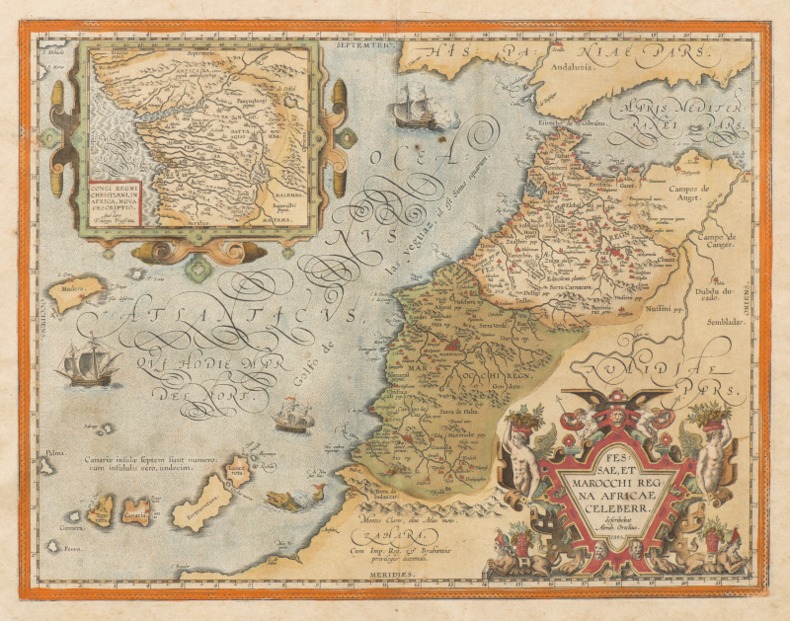
ORTELIUS (Abraham).
FESSAE, ET MAROCCHI REGNA AFRICAE CELEBERR. [Et] BARBARIAE ET BILEDULGERID, nova descriptio. [2 cartes XVIe du MAROC].
1595 [Anvers], Ortelius, 1595. Deux cartes (51 X 39 cm) et (50 X 33 cm) sous cadres en pichepin.
書籍販売業者の参照番号
: 004429
|
|
|
ORTELIUS Abraham (1527 - 1598).-
Gallia Vetus Ad Juliy Caesaris commentaria ex conatibus geographicis Abrah. Ortely. 1590.-
Grande carte en coloris ancien de la Gaule selon les Commentaires de Jules César. Elle donne les noms des villes, des cours d'eau, des principaux peuples (dont la liste détaillée est dressée dans les 2 colonnes qui bordent la carte). Les grandes régions sont écrites en grosses lettres rouges, les forêts indiquées en vert, les montagnes en brun. Elle est agrémentée de deux cartouches colorés et 3 vaisseaux, 2 dans l'Atlantique, un dans la Méditerranée. Ortelius. 1590. Dimensions totales 435 x 540 mm, dimensions de la carte elle-même 465 x 358 mm. Texte en latin au dos. Pli central d'origine. Excellent état.
書籍販売業者の参照番号
: ORD-7945
|
|
|
ORTELIUS (Abraham);
Graeciae universae secundum hodiernum situm neoterica descriptio.
Anvers 1603 365 x 515 mm.
書籍販売業者の参照番号
: LBW0394b
|
|
|
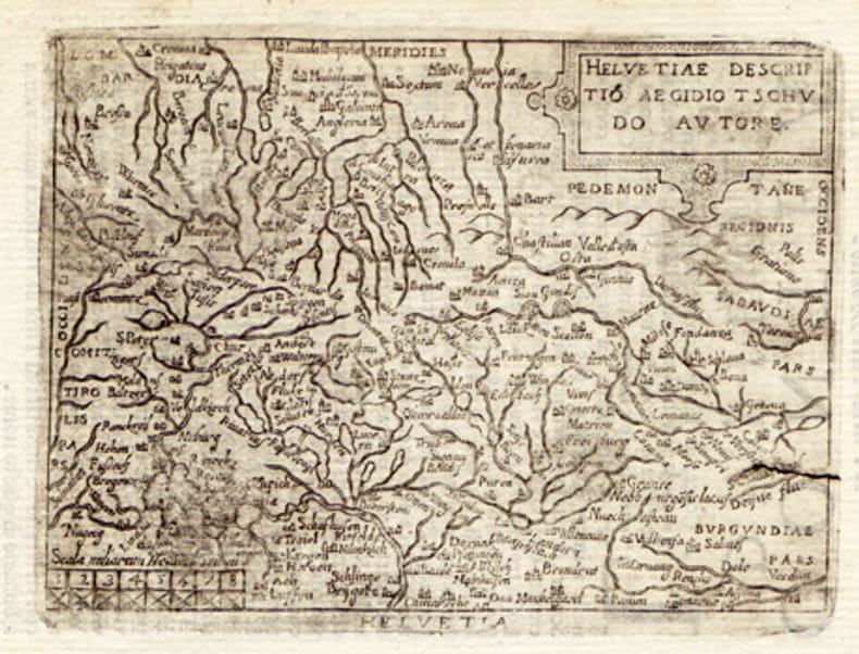
ORTELIUS, Abraham (1527-1598):
Helvetiae descriptio. Carte gravée de la Suisse.
1608, 7.5 x 10.5 cm, carte gravée légèrement tachée + 1 feuille avec le début de la description de la Suisse en italien, 2 feuilles (13 x 9 cm).
書籍販売業者の参照番号
: 100865aaf
|
|
|
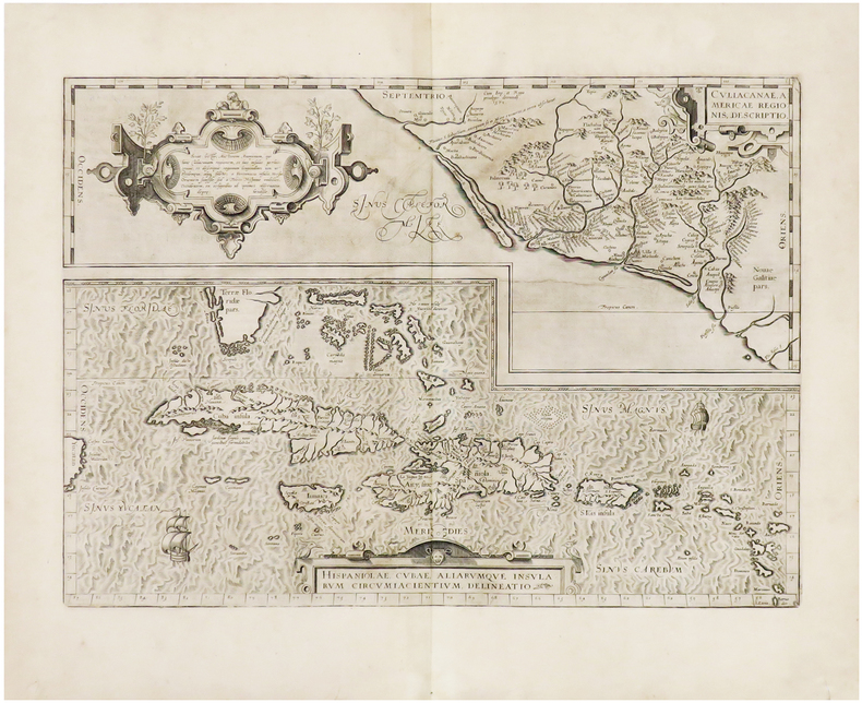
ORTELIUS (Abraham).
Hispaniolae, Cubae, aliarumque insularum circumiacientium, delineatio - Culiacanae, Americae regionis, descriptio.
[Anvers, 1608]. 355 x 498 mm.
書籍販売業者の参照番号
: LBW-943
|
|
|
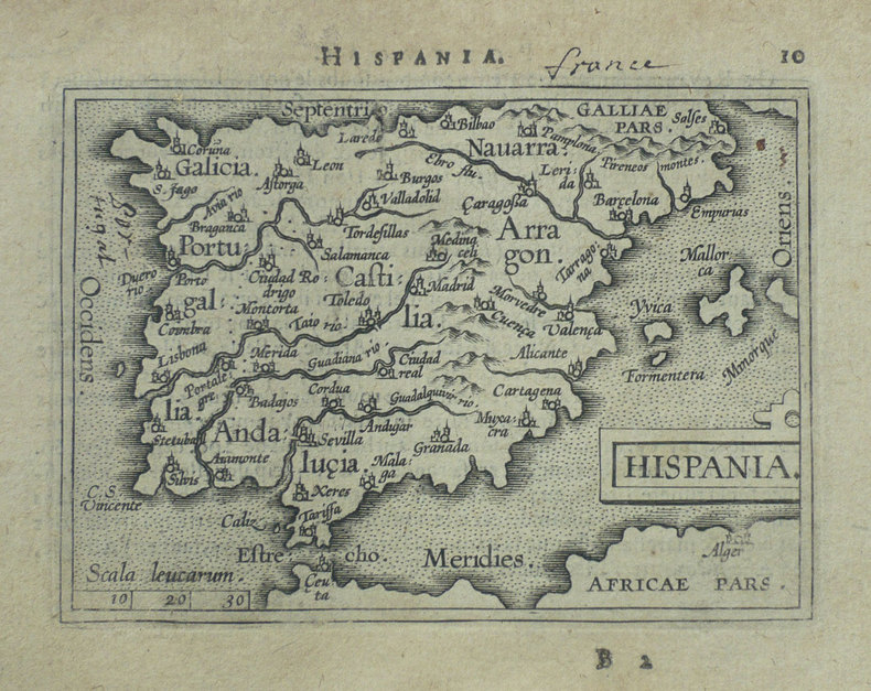
ORTELIUS (Abraham);
Hispania.
Anvers 1598 82 x 107 mm.
書籍販売業者の参照番号
: LBW-1404
|
|
|
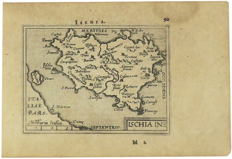
ORTELIUS (Abraham).
Ischia ins.
[Anvers, 1598]. 82 x 106 mm.
書籍販売業者の参照番号
: LBW-1405
|
|
|
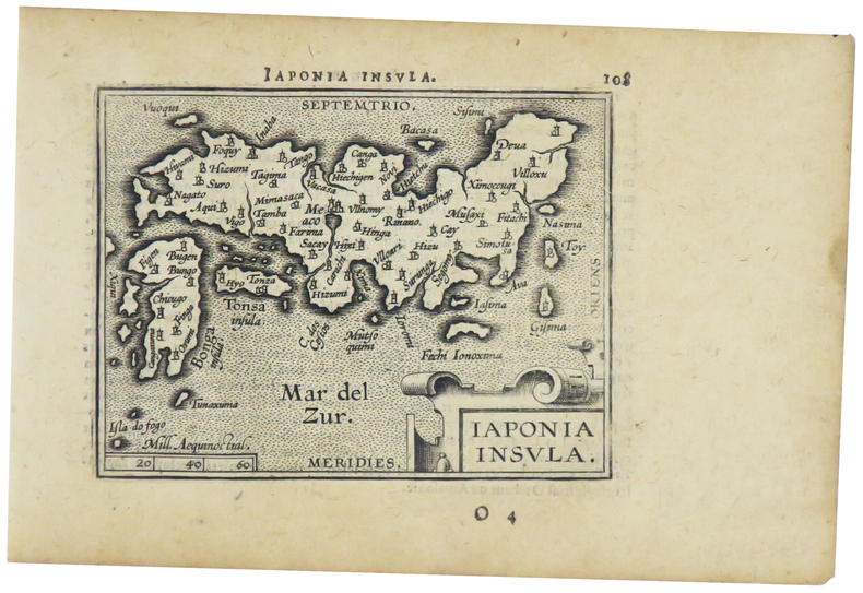
ORTELIUS (Abraham).
Japonia insula.
[Anvers, 1598]. 82 x 102 mm.
書籍販売業者の参照番号
: LBW-1424
|
|
|
ORTELIUS (Abraham)
Le Berry et la Limagne d'Auvergne. "Regionis Biturigum exactis: descriptio per Joanum Calamaeum". "Limaniae topographia, Gabrielle Symoneo auctor."
Anvers Deux cartes sur une feuille 39,5 x 52,5 cm. Gravure en noir rehaussée en couleurs (bleu, rouge, ocre et vert). Description en latin au dos. Impression fin XVIème ou début XVIIème siècle.
書籍販売業者の参照番号
: 3144

|
|
|
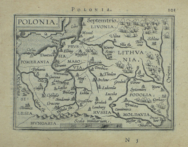
ORTELIUS (Abraham);
Polonia.
Anvers 1598 82 x 108 mm.
書籍販売業者の参照番号
: LBW-1390
|
|
|
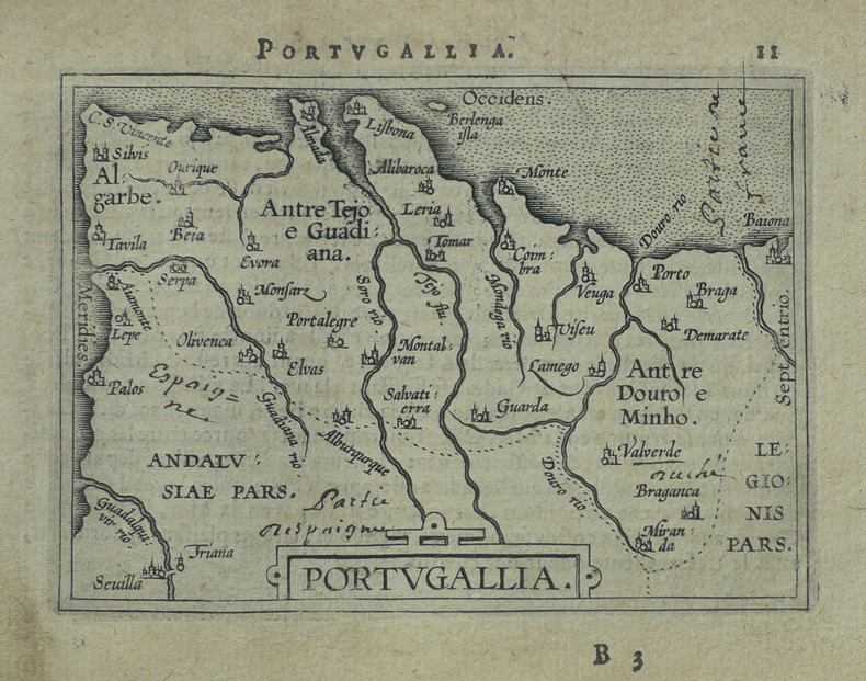
ORTELIUS (Abraham);
Portugallia.
Anvers 1598 81 x 106 mm.
書籍販売業者の参照番号
: LBW-1384
|
|
|
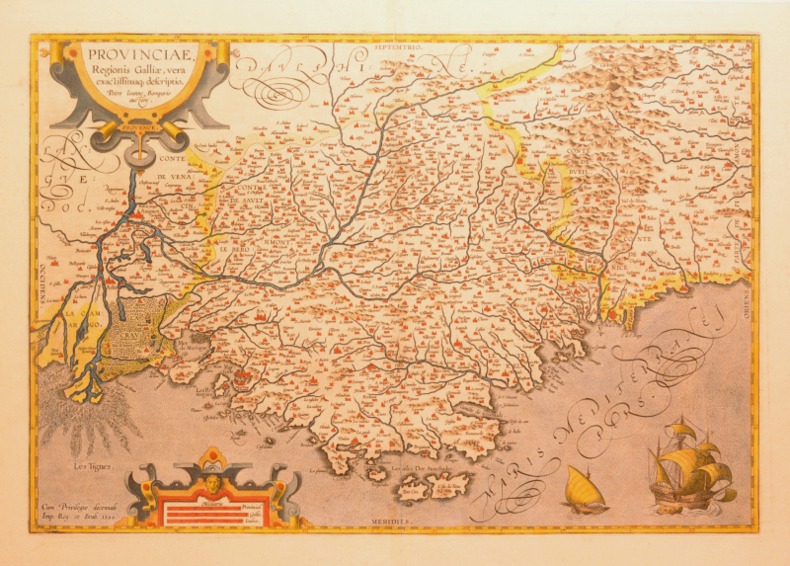
ORTELIUS (Abraham).
PROVINCIAE, REGIONIS GALLIAE, VERA EXACTISSIMAQ DESCRIPTIO. Petro Ioanne Bompario auctore. PROVENCE.
1595 [Anvers], Ortelius, 1594. Carte (557 X 405 mm, marges comprises) sous cadre en bois noirci moderne.
書籍販売業者の参照番号
: 004430
|
|
|
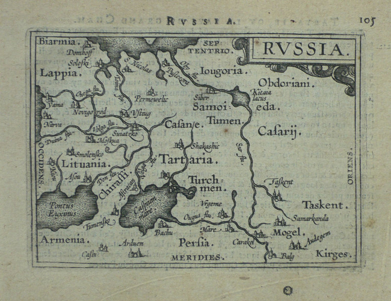
ORTELIUS (Abraham).
Russia.
[Anvers, 1598]. 80 x 106 mm.
書籍販売業者の参照番号
: LBW-1431
|
|
|
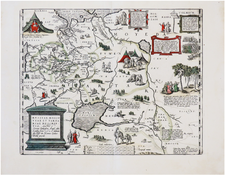
ORTELIUS (Abraham).
Russiæ, Moscoviæ et Tartariæ descriptio.
[Anvers, 1595-1601]. 348 x 442 mm.
書籍販売業者の参照番号
: LBW-7252
|
|
|
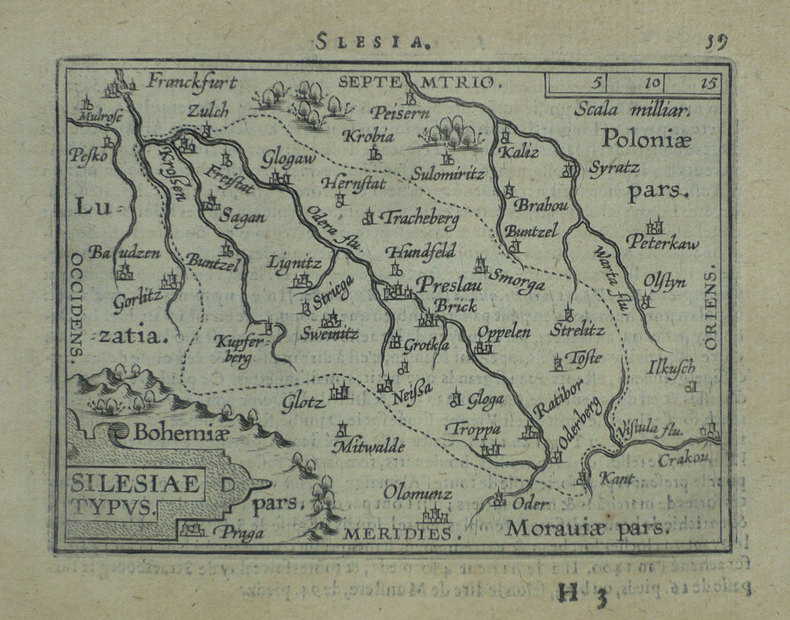
ORTELIUS (Abraham);
Silesiae typus.
Anvers 1598 81 x 106 mm.
書籍販売業者の参照番号
: LBW-1391
|
|
|
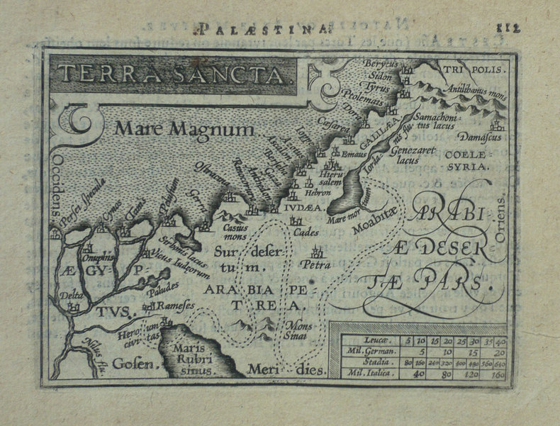
ORTELIUS (Abraham);
Terra sancta.
Anvers 1598 80 x 105 mm.
書籍販売業者の参照番号
: LBW-1425
|
|
|
ORTELIUS, Abraham
Theatro del mondo. L'atlas de poche d'Ortelius
L’Atlas de poche d’Ortelius en italien, complet de ses 108 cartes à pleine page, conservé dans sa reliure de l’époque. Venetia, Per Scipion Banca, 1667. In-16 de (4) ff., 232 pp., (8) ff. 108 cartes gravées à pleine page. Relié en vélin rigide de l’époque. Ex libris manuscrit sur le faux titre : « Bibliotheca Neorelli ». 133 x 93 mm.
書籍販売業者の参照番号
: LCS-1863

|
|
|
ORTELIUS (Abraham);
Turcicum Imperium.
Anvers 1598 81 x 105 mm.
書籍販売業者の参照番号
: LBW-1428

|
|
|
Ortega Abraham Luis
Carlos Chevilly de los Rios Spanish Edition
Confederacion Espanola de Cajas de Ahorros. Used - Very Good. Ships from Reno NV. Great condition for a used book! Minimal wear. 100% Money Back Guarantee. Shipped to over one million happy customers. Your purchase benefits world literacy! Confederacion Espanola de Cajas de Ahorros unknown
書籍販売業者の参照番号
: GRP89145756 ISBN : 8472314316 9788472314313
|
|
|
Ortelius Abraham
ABRAHAM ORTELII ANTUERPIANI THESAURUS GEOGRAPHICUS RECOGNITUS ET AUCTUS.
Hanover: Guilielmi Antonii 1611. 1236pp. Small quarto. Later stiff vellum gilt. Ink stamp on titlepage. Heavily tanned throughout. Good. Third edition enlarged. Ortelius together with Mercator was the most famous 16th-century cartographer. His geographical gazetteer was first published in 1587. This edition contains nearly 40000 place names arranged alphabetically each with a brief etymology and indication of source. There is also an index of "modern" names with their Latin equivalents. SABIN 57709. EUROPEAN AMERICANA 611/87. Guilielmi Antonii hardcover
書籍販売業者の参照番号
: WRCAM47267

|
|
|
ORTELIUS ABRAHAM: Marcel van den Broecke Peter van der Krogt & Peter Meurer eds.
Abraham Ortelius and the first atlas. Essays commemorating the Quadricentennial of his Death 1598-1998. With an introduction by Leon Voet and with 20 contributions by G�nter Schilder Rodney Shirley Dennis Reinhartz and others
't Goy HES 1998. Orig. red cloth hardcover gilt. 432 pp.: richly illustrated some in col.; 31x25 cm. - As new price when new EUR 17500. See picture. Weight is 2.4 kg. ISBN: 9061943884 't Goy, HES, 1998 hardcover
書籍販売業者の参照番号
: 36025 ISBN : 9061943884 9789061943884

|
|
|
Ortelius Abraham
Abrahami Ortelii Antuerpiani Thesaurus geographicus recognitus et auctus : in quo omnium totius terrae regionum montium promontoriorum collium syluarum desertorum insularum portuum populorum vrbium opidorum pagorum fanorum tribuum: item oceani marium fretorum fluuiorum torrentium sinuum fontium lacuum paludemque nomina & appellationes veteres; additis magna ex parte etiam recentioribus. Ex libris typis excusis calamo exaratis chartis geographicis marmoribus vetustis nummis atque tabulis antiqui aeris. Obiter multi in hoc opere auctorum veterum loci corrupti falsi dubii & discrepantes emendantur arguuntur enodantur & conciliantur 1611 Leather Bound
2020. Leather Bound. New. Leather Binding on Spine and Corners with Golden Leaf Printing on round Spine extra customization on request like complete leather Golden Screen printing in Front Color Leather Colored book etc. Reprinted in 2020 with the help of original edition published long back 1611. This book is printed in black & white sewing binding for longer life Printed on high quality Paper re-sized as per Current standards professionally processed without changing its contents. As these are old books we processed each page manually and make them readable but in some cases some pages which are blur or missing or black spots. If it is multi volume set then it is only single volume if you wish to order a specific or all the volumes you may contact us. We expect that you will understand our compulsion in these books. We found this book important for the readers who want to know more about our old treasure so we brought it back to the shelves. Hope you will like it and give your comments and suggestions. Lang: - lat Pages 1246. EXTRA 10 DAYS APART FROM THE NORMAL SHIPPING PERIOD WILL BE REQUIRED FOR LEATHER BOUND BOOKS. COMPLETE LEATHER WILL COST YOU EXTRA US$ 25 APART FROM THE LEATHER BOUND BOOKS. FOLIO EDITION IS ALSO AVAILABLE. hardcover
書籍販売業者の参照番号
: LB1111017072579
|
|
|
Ortelius Abraham
Abrahami Ortelii Antverpiani Synonymia geographica sive populorum regionum insularum . appellationes & nomina. : Opus non tantùm geographis sed etiam historiæ & poëseos studiosis vtile ac necessarium 1578 Leather Bound
2020. Leather Bound. New. Leather Binding on Spine and Corners with Golden Leaf Printing on round Spine extra customization on request like complete leather Golden Screen printing in Front Color Leather Colored book etc. Reprinted in 2020 with the help of original edition published long back 1578. This book is printed in black & white sewing binding for longer life Printed on high quality Paper re-sized as per Current standards professionally processed without changing its contents. As these are old books we processed each page manually and make them readable but in some cases some pages which are blur or missing or black spots. If it is multi volume set then it is only single volume if you wish to order a specific or all the volumes you may contact us. We expect that you will understand our compulsion in these books. We found this book important for the readers who want to know more about our old treasure so we brought it back to the shelves. Hope you will like it and give your comments and suggestions. Lang: - lat Pages 438. EXTRA 10 DAYS APART FROM THE NORMAL SHIPPING PERIOD WILL BE REQUIRED FOR LEATHER BOUND BOOKS. COMPLETE LEATHER WILL COST YOU EXTRA US$ 25 APART FROM THE LEATHER BOUND BOOKS. FOLIO EDITION IS ALSO AVAILABLE. hardcover
書籍販売業者の参照番号
: LB1111017072724
|
|
|
Ortelius Abraham
Abrahami Ortelii Antuerpiani Thesaurus geographicus recognitus et auctus : in quo omnium totius terrae regionum montium promontoriorum collium syluarum desertorum insularum portuum populorum vrbium opidorum pagorum fanorum tribuum: item oceani marium fretorum fluuiorum torrentium sinuum fontium lacuum paludemque nomina & appellationes veteres; additis magna ex parte etiam recentioribus. Ex libris typis excusis calamo exaratis chartis geographicis marmoribus vetustis nummis atque tabulis antiqui aeris. Obiter multi in hoc opere auctorum veterum loci corrupti falsi dubii & discrepantes emendantur arguuntur enodantur & conciliantur 1611
2020. Softcover. New. Lang: - lat Pages 1246. Reprinted in 2020 with the help of original edition published long back 1611. This book is Printed in black & white sewing binding for longer life with Matt laminated multi-Colour Soft Cover HARDCOVER EDITION IS ALSO AVAILABLE Printed on high quality Paper re-sized as per Current standards professionally processed without changing its contents. As these are old books we processed each page manually and make them readable but in some cases some pages which are blur or missing or black spots. If it is multi volume set then it is only single volume if you wish to order a specific or all the volumes you may contact us. We expect that you will understand our compulsion in these books. We found this book important for the readers who want to know more about our old treasure so we brought it back to the shelves. Any type of Customisation is possible. Hope you will like it and give your comments and suggestions. paperback
書籍販売業者の参照番号
: PB1111017072579
|
|
|
Ortelius Abraham
Abrahami Ortelii Antverpiani Synonymia geographica sive populorum regionum insularum . appellationes & nomina. : Opus non tantùm geographis sed etiam historiæ & poëseos studiosis vtile ac necessarium 1578
2020. Softcover. New. Lang: - lat Pages 438. Reprinted in 2020 with the help of original edition published long back 1578. This book is Printed in black & white sewing binding for longer life with Matt laminated multi-Colour Soft Cover HARDCOVER EDITION IS ALSO AVAILABLE Printed on high quality Paper re-sized as per Current standards professionally processed without changing its contents. As these are old books we processed each page manually and make them readable but in some cases some pages which are blur or missing or black spots. If it is multi volume set then it is only single volume if you wish to order a specific or all the volumes you may contact us. We expect that you will understand our compulsion in these books. We found this book important for the readers who want to know more about our old treasure so we brought it back to the shelves. Any type of Customisation is possible. Hope you will like it and give your comments and suggestions. paperback
書籍販売業者の参照番号
: PB1111017072724
|
|
|
Ortelius Abraham
Abrahami Ortelii Antverpiani Synonymia geographica sive populorum regionum insularum . appellationes & nomina. : Opus non tantùm geographis sed etiam historiæ & poëseos studiosis vtile ac necessarium 1578 Full Leather Bound
2020. SUPER DELUXE EDITION. New. Antique look with Golden Leaf Printing and embossing with round Spine completely handmade bindingextra customization on request like Color Leather Colored book special gold leaf printing etc. Reprinted in 2020 with the help of original edition published long back 1578. This book is printed in black & white sewing binding for longer life Printed on high quality Paper re-sized as per Current standards professionally processed without changing its contents. As these are old books we processed each page manually and make them readable but in some cases some pages which are blur or missing or black spots. If it is multi volume set then it is only single volume if you wish to order a specific or all the volumes you may contact us. We expect that you will understand our compulsion in these books. We found this book important for the readers who want to know more about our old treasure in old look so we brought it back to the shelves. Hope you will like it and give your comments and suggestions. Lang: - lat Pages 438. EXTRA 10 DAYS APART FROM THE NORMAL SHIPPING PERIOD WILL BE REQUIRED. Normal Hardbound Edition is also available on request. unknown
書籍販売業者の参照番号
: SD1111017072724
|
|
|
Ortelius Abraham
Abrahami Ortelii Antuerpiani Thesaurus geographicus recognitus et auctus : in quo omnium totius terrae regionum montium promontoriorum collium syluarum desertorum insularum portuum populorum vrbium opidorum pagorum fanorum tribuum: item oceani marium fretorum fluuiorum torrentium sinuum fontium lacuum paludemque nomina & appellationes veteres; additis magna ex parte etiam recentioribus. Ex libris typis excusis calamo exaratis chartis geographicis marmoribus vetustis nummis atque tabulis antiqui aeris. Obiter multi in hoc opere auctorum veterum loci corrupti falsi dubii & discrepantes emendantur arguuntur enodantur & conciliantur 1611 Full Leather Bound
2020. SUPER DELUXE EDITION. New. Antique look with Golden Leaf Printing and embossing with round Spine completely handmade bindingextra customization on request like Color Leather Colored book special gold leaf printing etc. Reprinted in 2020 with the help of original edition published long back 1611. This book is printed in black & white sewing binding for longer life Printed on high quality Paper re-sized as per Current standards professionally processed without changing its contents. As these are old books we processed each page manually and make them readable but in some cases some pages which are blur or missing or black spots. If it is multi volume set then it is only single volume if you wish to order a specific or all the volumes you may contact us. We expect that you will understand our compulsion in these books. We found this book important for the readers who want to know more about our old treasure in old look so we brought it back to the shelves. Hope you will like it and give your comments and suggestions. Lang: - lat Pages 1246. EXTRA 10 DAYS APART FROM THE NORMAL SHIPPING PERIOD WILL BE REQUIRED. Normal Hardbound Edition is also available on request. unknown
書籍販売業者の参照番号
: SD1111017072579
|
|
|
Ortelius Abraham Sweerts Pierre Francois Galle Philippe
Abrahami Ortelii cosmographi et geographi regii Deorum dearumque capita ex antiquis numismatibus collecta 1683 Leather Bound
2019. Leather Bound. New. Leather Binding on Spine and Corners with Golden Leaf Printing on round Spine. Reprinted in 2019 with the help of original edition published long back 1683. This book is printed in black & white sewing binding for longer life Printed on high quality Paper re-sized as per Current standards professionally processed without changing its contents. As these are old books we processed each page manually and make them readable but in some cases some pages which are blur or missing or black spots. If it is multi volume set then it is only single volume if you wish to order a specific or all the volumes you may contact us. We expect that you will understand our compulsion in these books. We found this book important for the readers who want to know more about our old treasure so we brought it back to the shelves. Hope you will like it and give your comments and suggestions. Lang: - lat Pages 198. EXTRA 10 DAYS APART FROM THE NORMAL SHIPPING PERIOD WILL BE REQUIRED FOR LEATHER BOUND BOOKS. FOLIO EDITION IS ALSO AVAILABLE. hardcover
書籍販売業者の参照番号
: LB1111005321974
|
|
|
Ortelius Abraham Plantin Christophe ca.
Abrahami Ortelii . Synonymia geographica siue Populorum regionum insularum vrbium opidorum montium . appellationes et nomina 1578 Leather Bound
2019. Leather Bound. New. Leather Binding on Spine and Corners with Golden Leaf Printing on round Spine. Reprinted in 2019 with the help of original edition published long back 1578. This book is printed in black & white sewing binding for longer life Printed on high quality Paper re-sized as per Current standards professionally processed without changing its contents. As these are old books we processed each page manually and make them readable but in some cases some pages which are blur or missing or black spots. If it is multi volume set then it is only single volume if you wish to order a specific or all the volumes you may contact us. We expect that you will understand our compulsion in these books. We found this book important for the readers who want to know more about our old treasure so we brought it back to the shelves. Hope you will like it and give your comments and suggestions. Lang: - lat Pages 435. EXTRA 10 DAYS APART FROM THE NORMAL SHIPPING PERIOD WILL BE REQUIRED FOR LEATHER BOUND BOOKS. FOLIO EDITION IS ALSO AVAILABLE. hardcover
書籍販売業者の参照番号
: LB1111008394051
|
|
|
Ortelius Abraham Plantin Christophe ca.
Abrahami Ortelii . Synonymia geographica siue Populorum regionum insularum vrbium opidorum montium . appellationes et nomina 1578
2020. Paperback. New. Lang: - lat Pages 435. Reprinted in 2020 with the help of original edition published long back 1578. This book is Printed in black & white sewing binding for longer life with Matt laminated multi-Colour Soft Cover HARDCOVER EDITION IS ALSO AVAILABLE Printed on high quality Paper re-sized as per Current standards professionally processed without changing its contents. As these are old books we processed each page manually and make them readable but in some cases some pages which are blur or missing or black spots. If it is multi volume set then it is only single volume if you wish to order a specific or all the volumes you may contact us. We expect that you will understand our compulsion in these books. We found this book important for the readers who want to know more about our old treasure so we brought it back to the shelves. Any type of Customisation is possible with extra charges. Hope you will like it and give your comments and suggestions. paperback
書籍販売業者の参照番号
: PB1111008394051
|
|
|
Ortelius Abraham Sweerts Pierre Francois Galle Philippe
Abrahami Ortelii cosmographi et geographi regii Deorum dearumque capita ex antiquis numismatibus collecta 1683 Hardcover
2020. Hardcover. New. Lang: - lat Pages 198. Reprinted in 2020 with the help of original edition published long back 1683. This book is Printed in black & white Hardcover sewing binding for longer life with Matt laminated multi-Colour Dust Cover Printed on high quality Paper re-sized as per Current standards professionally processed without changing its contents. As these are old books we processed each page manually and make them readable but in some cases some pages which are blur or missing or black spots. If it is multi volume set then it is only single volume if you wish to order a specific or all the volumes you may contact us. We expect that you will understand our compulsion in these books. We found this book important for the readers who want to know more about our old treasure so we brought it back to the shelves. Any type of Customisation is possible with extra charges. Hope you will like it and give your comments and suggestions. hardcover
書籍販売業者の参照番号
: 1111005321974
|
|
|
Ortelius Abraham Sweerts Pierre Francois Galle Philippe
Abrahami Ortelii cosmographi et geographi regii Deorum dearumque capita ex antiquis numismatibus collecta 1683
2020. Paperback. New. Lang: - lat Pages 198. Reprinted in 2020 with the help of original edition published long back 1683. This book is Printed in black & white sewing binding for longer life with Matt laminated multi-Colour Soft Cover HARDCOVER EDITION IS ALSO AVAILABLE Printed on high quality Paper re-sized as per Current standards professionally processed without changing its contents. As these are old books we processed each page manually and make them readable but in some cases some pages which are blur or missing or black spots. If it is multi volume set then it is only single volume if you wish to order a specific or all the volumes you may contact us. We expect that you will understand our compulsion in these books. We found this book important for the readers who want to know more about our old treasure so we brought it back to the shelves. Any type of Customisation is possible with extra charges. Hope you will like it and give your comments and suggestions. paperback
書籍販売業者の参照番号
: PB1111005321974
|
|
|
Ortelius Abraham Plantin Christophe ca.
Abrahami Ortelii . Synonymia geographica siue Populorum regionum insularum vrbium opidorum montium . appellationes et nomina 1578 Hardcover
2020. Hardcover. New. Lang: - lat Pages 435. Reprinted in 2020 with the help of original edition published long back 1578. This book is Printed in black & white Hardcover sewing binding for longer life with Matt laminated multi-Colour Dust Cover Printed on high quality Paper re-sized as per Current standards professionally processed without changing its contents. As these are old books we processed each page manually and make them readable but in some cases some pages which are blur or missing or black spots. If it is multi volume set then it is only single volume if you wish to order a specific or all the volumes you may contact us. We expect that you will understand our compulsion in these books. We found this book important for the readers who want to know more about our old treasure so we brought it back to the shelves. Any type of Customisation is possible with extra charges. Hope you will like it and give your comments and suggestions. hardcover
書籍販売業者の参照番号
: 1111008394051
|
|
|
Ortelius Abraham
Abruzzo" "Aprutium
Europe: Antwerp Joannem Bapt. Vrientium/ Vrients. 1601. Copper engraved minature map by Phillip Galle of Abruzzo from" Epitome theatri Orteliani praecipuarum orbis regionum delinaetiones. . Editio ultima" Latin text to verso describing the succeeding map. . Dark impression overall toning. The first edition of the"Epitome" in 1577 a reduced format atlas with minature maps of Abraham Ortelius's "Theatrum" is believed to have been the initiative of the engraver Phillip Galle who asked Peter Heyns to write the text. Ortelius had fled to England in 1576 having taken refuge there from Spanish oppression and may have been unaware of the plan of his two friends. The pocket atlas was a a commmercial success and was reprinted several times with Galle adding many new maps and replacing some. Jan. Baptist Vrients bought the rights and plates of the Epitome from Phillip Galle in 1601 . he published 4 editions using the Galle plates of which this is the first with Latin text. Koeman Ort58; Phillips 413; Europe Italy Abruzzo Aprutium Antwerp Joannem Bapt. Vrientium/ Vrients. 1601 unknown
書籍販売業者の参照番号
: 1343

|
|
|
Ortelius Abraham
Aeneae Troiani Navigatio as Virgilii sex priores Aeneidos.
Antwerp: Plantin-Moretus 1624. Copper engraving 35 x 49 cms trivial adhesion damage in left hand part of the map above a depiction of the storm which preceded Aeneas� landing at Carthage; modern hand colour Latin text on verso. Map of the eastern Mediterranean which depicts the wanderings of the legendary Trojan prince Aeneas after the fall of Troy "according to the first six books of Virgil's Aeneid" the epic poem which served as Rome's foundation myth. Our example was published by Balthasar Moretus at the Plantin Press in the final edition of the Parergon. Ortelius's Theatrum Orbis Terrarum is generally considered the first modern atlas of the world originally published in 1570. Ortelius gathered and selected the best available cartographic knowledge and presented it in a single volume duly credited and finely engraved in a consistent style with explanatory text. The Theatrum was very decorative and hugely popular amongst the wealthy and educated running into over forty editions in Latin and the major European languages. For Ortelius himself however his accompanying atlas of ancient geography the Parergon was a "personal work" Koeman. He seems to have regarded himself first and foremost as an antiquary and rather than copying other people's maps he drew the originals himself; they were subsequently engraved for him by the master engraver Jan Wierix. The results �have to be evaluated as the most outstanding engravings depicting the wide-spread interest in classical geography in the 16th century� Koeman. Koeman Atlantes Neerlandici Ort 46. Van den Broecke 223.3 Map Plantin-Moretus unknown
書籍販売業者の参照番号
: 8001
|
|
|
ORTELIUS ABRAHAM
Album amicorum: Reproduit en facsimilé annoté et traduit
A.L. van Gendt & Co 1969. Text in french Super octavo blue cloth boards with gilt lettering to spine 125pp illus VG Light rubbing to boards light foxing to page edges A.L. van Gendt & Co, 1969 hardcover
書籍販売業者の参照番号
: 231099
|
|
|
ORTELIUS Abraham
Americae Sive Novi Orbis Nova Descripto
1612. unbound. very good. Engraving. Image measures 14" x 19" sheet measures 19" x 23". This stunning 1612 map by Abraham Ortelius depicts the Western Hemisphere. At the time it was issued the coastal areas of the New World had been fairly well explored and Europeans were just beginning settlement and colonization. It is notable for depicting Spanish and Portuguese colonies in high detail for these powers were notoriously protective of their geographical surveys. This is the first state of the third plate engraved for Ortelius's landmark map of the New World. It is distinguished from the first two plates by the lack of the bulge to the southwest coast of South America. Several other cartographic enhancements are apparent on closer inspections. Abraham Ortelius 1527--1598 a Flemish cartographer and geographer is widely regarded as one of the important and influential cartographers in history. He is known for his "Theatrum Orbis Terrarum" which was the first modern atlas. Very hard to find in black and white. unknown
書籍販売業者の参照番号
: 286194

|
|
|
ORTELIUS Abraham 1527 1598.
Americae sive Novi orbis nova Descriptio
Amsterdam: Abraham Ortelius 1587. Original copperplate 12 4/8 x 19 inches. UNIQUE AND EXCEPTIONALLY FINE ENGRAVED COPPERPLATE of America on an oval projection with the title in an elaborate cartouche lower left and the ocean decorated with many ships and a sea-monster surrounded by a decorative border Some scratches and scuff marks old repair to top left of the cartouche. EXTREMELY RARE ORIGINAL COPPERPLATE FOR ORTELIUS'S IMPORTANT MAP OF THE AMERICAS. First issued in 1570 Ortelius's America 'was widely sold throughout Europe and had a great influence on the future cartography of the New World'. In the present copperplate the outlines of South America are considerably improved and without the bulge in Chili are much closer to those recognised today. It almost but not entirely corresponds to the third issue of the map Burden 64 which was the first to carry the cartographer's name. The small differences lie in an error to '270' degrees longitude here engraved '70' and in the historiated ornament at the corners. No antiquarian map issued from this plate is known. However the map published in the 1579 edition of Theatrum orbis terrarum contains the same error in numbering and this error was presumably copied. The use of two different plates in the printing of maps is not unusual but the differences are generally more important. We are grateful to Marcel van den Broecke for his help with this catalogue description see also his article on this copperplate published in Map Forum 2005 VII pp. 28-32. Catalogued by Kate Hunter. [Amsterdam]: Abraham Ortelius, 1587. unknown
書籍販売業者の参照番号
: 72copperplate1
|
|
|
Ortelius Abraham
Americae Sive Novi Orbis Nova Descriptio Reprinted Engraved Antique Map
: Abraham Ortelius Original 1587 But This A Reprint 1587. 5th or later Edition . No Binding. Near Fine/No Jacket. 19" x 17. Image Size: 18 7/8" X 13 3/4". Text "Cum Privilegio Decennali Ab. Ortelius Delineab. Et Excudeb. 1587" At Lower Right. However This Must Be A Late Eighteenth Century To Twentieth Century Reprint Printed On Wove Paper Sheet Never Placed In An Atlas. Strong Impression And Color Minor Loss Of A Millimeter Depth In A Tiny Area Of Lower Left Margin Otherwise Undamaged. Margins Irregular Up To 1" Deep. Professionally Cleaned And De-Acidified With Archival Materials By A Museum-Experienced Conservator. <br/> <br/> Abraham Ortelius (Original 1587 But This A Reprint) unknown
書籍販売業者の参照番号
: 016842

|
|
|
ORTELIUS Abraham
Americae Sive Novi Orbis Nova Descriptio
Abraham Ortelius 1612. unbound. very good. Map. Engraving with hand coloring. Image measures 14" x 19.25". This stunning 1612 map by Abraham Ortelius depicts the Western Hemisphere. At the time it was issued the coastal areas of the New World had been fairly well explored and Europeans were just beginning settlement and colonization. It is notable for depicting Spanish and Portuguese colonies in high detail for these powers were notoriously protective of their geographical surveys. This is the first state of the third plate engraved for Ortelius's landmark map of the New World. It is distinguished from the first two plates by the lack of the bulge to the southwest coast of South America. Several other cartographic enhancements are apparent on closer inspections. The Solomon Islands are depicted here for the first time since their discovery in 1568 by Alvaro de Mendana. The map identifies several places previously unpublished due to political reasons. These were provided to Ortelius by Haklyut on the basis of recent explorations. The nomenclature in California is also included. Perhaps the most notable enhancements on the east coast is the Indian name Wingandkoa and an inlet just above possibly the first depiction of the Chesapeake Bay on a printed map reflecting early English efforts at Colonization in the Outer Banks of the Carolinas. Based on Gerard Mercators 1569 World Map this map includes an abundance of cartographic speculation representing the knowledge of the region during the time. The kingdom of Quivira the supposed ancient city of gold in North America. Conquistador Francisco V�zquez de Coronado searched for Quivira for several years to finally find it was no more than American Indian settlement of farming people. Terro del Fueggo first reached by Magellan is here shown to be part of the large speculated continent of Terra Australis that extends westward with the annotation "The southern of Magellanican land as yet unknown". Other interesting annotations throughout include "Somewhere here there are islands which according to some have gold" and Patagonia shows a notation that suggests its inhabitants were giants. The waters are ornamented with illustrations of ships and a sea monster. In earlier plates the ships are different. A large title cartouche is included in the bottom left. Another scale cartouche appears in the top left. Published in the 1612 or 1608 edition the map is identical in both editions of Ortelius' famous "Theatrum Orbis Terrarum" which is historically considered the first modern atlas. Based on the text on verso only 300 copies of this particular edition were ever printed van der Broecke 11. Italian text on verso. Minor chipping to edges. Full original margins. Minor wear along original centerfold. Abraham Ortelius 1527--1598 a Flemish cartographer and geographer is widely regarded as one of the important and influential cartographers in history. He is known for his "Theatrum Orbis Terrarum" which was the first modern atlas. Abraham Ortelius unknown
書籍販売業者の参照番号
: 219257

|
|
|
Ortelius Abraham
Andegavenium Ducatus. " Anjou Andegavensium Ditionis Vera et Integra Descriptio
Europe: Antverpiæ"/Antwerp. "ex Officiana Plantiana" . Plantijn Christoffel. 1595. Copper engraved map of Anjou after Licinio Guyeto/ Lezin Guyet 1515-80 from Ortelius' "Theatrum Orbis Terrarum" 1595 edition; black & white. Latin text to verso. Good dark impression: wormhole to lower centrefold within "MERIDIES"; tear 18mmat lower centrefold caused by guard repaired. Abraham Ortelius 1527-1598 Flemish Cartographer . produced the first modern Atlas "Theatrum Orbis Terrarum" in 1570. printed by Aegidus Coppen Diest. There were numerous editions thereafter with texts in various languages; the printing of such was taken over by Chrstoffel Plantijn in 1579 . Ortelius himself drew all the maps in manuscript before passing them to the printers. there is conjecture that he may have engraved some of the plates as well The 1595 Latin text edition is the most complete produced during his lifetime containing all the maps of the 1593 edition plus those of the the"Additamentum" and the"Pareragon" or Ancient geography. The " Additamenta" were supplements to the original Atlas; at the same time Ortelius replaced some maps with new ones showing the same place; some plates were also reworked . Ortelius was Geographer Royal To Phillip II of Spain from 1575. He also worked closely with Braun & Hogenburg on the "Civitas Orbis Terarum". After his death the plates were purchased by Jan Baptiste Vrients in 1601 who published further editions until 1612. Van de Krogt :3; .Koeman: Ort29: 25 76; van.de. Broecke:40. Europe France Anjou Andegavenium Antverpiæ"/Antwerp. "ex Officiana Plantiana" . Plantijn Christoffel. 1595 unknown
書籍販売業者の参照番号
: 1812

|
|
|
Ortelius Abraham
Angliae Scotiae et Hiberniae Sive Britannicar: Insularum Descriptio
Amsterdam: Ortelius 1575. Very good overall. A classic map of the British Isles published in the 'Theatrum Orbis Terrarum' regarded as the first modern atlas. The map was oriented with north to the right so that the map fitted the sheet of paper as it predates the convention of north to the top of the map. Ort 16 Koeman/Meurer: 6 Karrow: 1/11 van der Krogt AN: 5000:31A. Listed on Van Den Broecke as 1575L6 100 copies printed small page number 7 mm; last line centred like 3 lines above it: sem;Ponticum Virunium;Ioannem Pris�um;&Bedam. Shirley: British Isles 1477-1650 86. Latin text on verso. 19 1/2 x 13 1/2". Centerfold and right margin strengthened. Original color heightened. <br/><br/> Ortelius unknown
書籍販売業者の参照番号
: 21270

|
|
|
ORTELIUS Abraham.
Angliae Scotiae et Hiberniae
Antwerp. c.1584-95. Size: 345 x 505 mm. Framed size: 780 x 640 mm. Copper engraving. Coloured. Fine condition good margins. A beautiful map of the British Isles north to the right. The map is based on Mercator's earlier map of the British Isles of 1564. Title in strapwork cartouche at top right text in Latin in its own cartouche at lower right scale and royal arms; ships at sea. It is difficult to put an exact date on the map because of the complex publishing history of Ortelius' atlas. Published in the Theatrum Orbis Terrarum. Moreland & Bannister p. 200-203; Van den Broecke 16. Antwerp. unknown
書籍販売業者の参照番号
: 53076

|
|
|
Ortelius Abraham
Angliae Scotiae et Hiberniae sive Britannica Insularum Descriptio. Double-page Map of England Scotland and Ireland with Royal Crest in upper right corner. Hand-Colored by a later hand
np 1590. Image area 19 1/2 x 13 1/2 inches in 28 x 23 inch mat. Single crease down center with one 1/2 inch spot worn through otherwise a nice handsome map. Image area 19 1/2 x 13 1/2 inches in 28 x 23 inch mat. Abraham Ortelius 1527-1598 was a Flemish geographer of German origin. His major work Theatrum Orbis Terrarum 1570 with later revisions and addenda was the first modern atlas. It was based on contemporary charts and maps and contained a collection of plates engraved by Franz Hagenberg in a uniform size and format. The Theatrum preceded the first Atlas of Ortelius' good friend Gerardus Mercator. In fact popular and sentimental legend has it that Mercator delayed publication of his own work so that his younger friend's would appear first. although this simply is not true Mercator wasn't ready the legendary cartographer did compliment Ortelius for the "care and elegance" he put into his "Theatrum. unknown
書籍販売業者の参照番号
: 37978
|
|
|
Ortelius Abraham
Aniou. " "Andegavensis Ducatus
Europe: Antwerp Joannem Bapt. Vrientium/ Vrients. 1601. Copper engraved minature map by Phillip Galle of Anjou France from" Epitome theatri Orteliani praecipuarum orbis regionum delinaetiones. . Editio ultima" Latin text to verso describing the succeeding map. . Dark impression overall toning light foxing to blank margins; one darker spot to lower blank margin The first edition of the"Epitome" in 1577 a reduced format atlas with minature maps of Abraham Ortelius's "Theatrum" is believed to have been the initiative of the engraver Phillip Galle who asked Peter Heyns to write the text. Ortelius had fled to England in 1576 having taken refuge there from Spanish oppression and may have been unaware of the plan of his two friends. The pocket atlas was a a commmercial success and was reprinted several times with Galle adding many new maps and replacing some. Jan. Baptist Vrients bought the rights and plates of the Epitome from Phillip Galle in 1601 . he published 4 editions using the Galle plates of which this is the first with Latin text. Koeman Ort58; Phillips 413; Europe France Anjou Antwerp Joannem Bapt. Vrientium/ Vrients. 1601 unknown
書籍販売業者の参照番号
: 1513

|
|
|
Ortelius Abraham
Asiae Nova Descriptio
Antwerp 1574. Maps. Very good overall. The Middle East to Nova Guinea with part of the coast line of Australia 'Terrae Incognitae' at the extreme lower right. Based on Ortelius' own 1567 wall map of Asia from the Theatrum Orbis Terrarum. Van den Broecke Ort #6 "Occurrence in Theatrum editions and page number: 1574L3 175 copies printed large page number 11 mm last line centered like 2 lines above it: nem in maiori Tabula ante tres annos edidimus". It has the capital "F" in La Farfana and the town "Ara" is still present above Aden. A total of only 1675 of this edition were printed compared to the more common Ort 7 edition. Image size:19 3/4 x 14 3/4". With an ornate cartouche and sailing ships. Latin text on verso. Paper size: 21 x 16 1/2". Copper engraving with original hand color. A very small burn hole at the ocean south of Japan; a defect in the plate at the lower edge to the right of the cartouche creating a short black line. <br/><br/> unknown
書籍販売業者の参照番号
: 15880

|
|
|
Ortelius Abraham
Asores Insula; Tercera; Pico; Fayala. "Açores Insulae
Europe: Antverpiæ"/Antwerp. "ex Officiana Plantiana" . Plantijn Christoffel. 1595. Copper engraved map of the islands of the Azores Portugal from Ortelius' "Theatrum Orbis Terrarum" 1595 edition; black & white. Latin text to verso. Decorative map of the most Western point of Europe the Azores belong to Portugal and as such Europe extends very far west into the Atlantic. 3 cartouches; ships & monsters to the sea. Good dark impression; tiny wormhole to lower centre fold within "MERIDES". Abraham Ortelius 1527-1598 Flemish Cartographer . produced the first modern Atlas "Theatrum Orbis Terrarum" in 1570. printed by Aegidus Coppen Diest. There were numerous editions thereafter with texts in various languages; the printing of such was taken over by Chrstoffel Plantijn in 1579 . Ortelius himself drew all the maps in manuscript before passing them to the printers. there is conjecture that he may have engraved some of the plates as well The 1595 Latin text edition is the most complete produced during his lifetime containing all the maps of the 1593 edition plus those of the the"Additamentum" and the"Pareragon" or Ancient geography. The " Additamenta" were supplements to the original Atlas; at the same time Ortelius replaced some maps with new ones showing the same place; some plates were also reworked . Ortelius was Geographer Royal To Phillip II of Spain from 1575. He also worked closely with Braun & Hogenburg on the "Civitas Orbis Terarum". After his death the plates were purchased by Jan Baptiste Vrients in 1601 who published further editions until 1612. Van de Krogt :3; .Koeman: Ort29 17595; van.de. Broecke:24. Europe Spain & Portugal Azores Asores Acores Tercera Pico fayala Antverpiæ"/Antwerp. "ex Officiana Plantiana" . Plantijn Christoffel. 1595 unknown
書籍販売業者の参照番号
: 1778

|
|
|
ORTELIUS Abraham.
ATREBATUM REGIONIS VERA DESCRIPTIO.
Antwerp. c.1595. Copper engraving. Later colour. Fine condition good margins. Size: 48 x 36.5 cm. Splendid map of the Artois region of north eastern France from Calais to Cambrai. Magnificent strapwork title cartouche at upper right scale with strapwork decorations at lower left. The dedicatory cartouche at left identifies this plate as van den Broecke 74. Published in the famous Theatrum Orbis Terrarum by the master Flemish cartographer Abraham Ortelius. Van den BroeckeOrtelius Atlas Maps 74. Antwerp. unknown
書籍販売業者の参照番号
: 53045

|
|
|
Ortelius Abraham
Auraicus Princ. " "AuRaicus Principatus
Europe: Antwerp Joannem Bapt. Vrientium/ Vrients. 1601. Copper engraved minature map by Phillip Galle of the Principality of Orange Southern France from" Epitome theatri Orteliani praecipuarum orbis regionum delinaetiones. . Editio ultima" Latin text to verso describing the succeeding map. . Dark impression; overall toning; light foxing/staining to blank margins; printed crooked on the page. The first edition of the"Epitome" in 1577 a reduced format atlas with minature maps of Abraham Ortelius's "Theatrum" is believed to have been the initiative of the engraver Phillip Galle who asked Peter Heyns to write the text. Ortelius had fled to England in 1576 having taken refuge there from Spanish oppression and may have been unaware of the plan of his two friends. The pocket atlas was a a commmercial success and was reprinted several times with Galle adding many new maps and replacing some. Jan. Baptist Vrients bought the rights and plates of the Epitome from Phillip Galle in 1601 . he published 4 editions using the Galle plates of which this is the first with Latin text. Koeman Ort58; Phillips 413; Europe France Orange Antwerp Joannem Bapt. Vrientium/ Vrients. 1601 unknown
書籍販売業者の参照番号
: 1522

|
|
 検索結果のメールを受信する
 PDFファイルの検索結果をダウンロード
 RSSフィード


