|
Ortelius Abraham
Pictavia. "Poictou / Poictonum Vicinarumque regionum Fidiss Descriptio
Europe: Antverpiæ"/Antwerp. "ex Officiana Plantiana" . Plantijn Christoffel. 1595. Copper engraved map of Poitiers/ Poitou France from Ortelius' "Theatrum Orbis Terrarum" 1595 edition; black & white. Latin text to verso. With 2 title cartouches the map shows the region of Poitiers to the Atlantic coast with the islands of Oleron & de Re. Good dark impression. Abraham Ortelius 1527-1598 Flemish Cartographer . produced the first modern Atlas "Theatrum Orbis Terrarum" in 1570. printed by Aegidus Coppen Diest. There were numerous editions thereafter with texts in various languages; the printing of such was taken over by Chrstoffel Plantijn in 1579 . Ortelius himself drew all the maps in manuscript before passing them to the printers. there is conjecture that he may have engraved some of the plates as well The 1595 Latin text edition is the most complete produced during his lifetime containing all the maps of the 1593 edition plus those of the the"Additamentum" and the"Pareragon" or Ancient geography. The " Additamenta" were supplements to the original Atlas; at the same time Ortelius replaced some maps with new ones showing the same place; some plates were also reworked . Ortelius was Geographer Royal To Phillip II of Spain from 1575. He also worked closely with Braun & Hogenburg on the "Civitas Orbis Terarum". After his death the plates were purchased by Jan Baptiste Vrients in 1601 who published further editions until 1612. Van de Krogt :3; .Koeman: Ort29: 23 75; van.de. Broecke:38. Europe France Poitiers Poitou Pictavia Poictou Antverpiæ"/Antwerp. "ex Officiana Plantiana" . Plantijn Christoffel. 1595 unknown
Referencia librero : 1809

|
|
|
Ortelius Abraham
Poitou. " "Pictavia
Europe: Antwerp Joannem Bapt. Vrientium/ Vrients. 1601. Copper engraved minature map by Phillip Galle of Poitou/ Poitiers Western France from" Epitome theatri Orteliani praecipuarum orbis regionum delinaetiones. . Editio ultima" Latin text to verso describing the succeeding map. . Dark impression; overall toning; light foxing/staining to blank margins. The first edition of the"Epitome" in 1577 a reduced format atlas with minature maps of Abraham Ortelius's "Theatrum" is believed to have been the initiative of the engraver Phillip Galle who asked Peter Heyns to write the text. Ortelius had fled to England in 1576 having taken refuge there from Spanish oppression and may have been unaware of the plan of his two friends. The pocket atlas was a a commmercial success and was reprinted several times with Galle adding many new maps and replacing some. Jan. Baptist Vrients bought the rights and plates of the Epitome from Phillip Galle in 1601 . he published 4 editions using the Galle plates of which this is the first with Latin text. Koeman Ort58; Phillips 413; Europe France Poitiers Poitou Antwerp Joannem Bapt. Vrientium/ Vrients. 1601 unknown
Referencia librero : 1517

|
|
|
ORTELIUS Abraham.
Poloniae Litvaniae Q Descriptio
Antwerp: Christopher Plantin 1584. Map. Fine. Framed. Size: 377 x 485 mm. Framed size: 580 x 465mm. Hand-coloured engraved map published in the Theatrum Orbis Terrarum. Wooden moulding frames glazed and mounted late 20th century. In fine condition only a small two spots in a upper part. A beautiful map of Poland and Lithuania part of the Baltic Sea title in cartouche at lower left in Latin scale at top left decorated sleigh with a horse. . Christopher Plantin Hardcover
Referencia librero : 001117

|
|
|
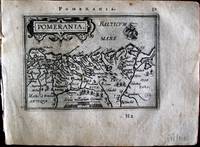
Ortelius Abraham
Pomerania. "
Europe: Antwerp Joannem Bapt. Vrientium/ Vrients. 1601. Copper engraved minature map by Phillip Galle of Pomerania from" Epitome theatri Orteliani praecipuarum orbis regionum delinaetiones. . Editio ultima" Latin text to verso describing the succeeding map. . Dark impression overall toning light foxing to blank margins. The first edition of the"Epitome" in 1577 a reduced format atlas with minature maps of Abraham Ortelius's "Theatrum" is believed to have been the initiative of the engraver Phillip Galle who asked Peter Heyns to write the text. Ortelius had fled to England in 1576 having taken refuge there from Spanish oppression and may have been unaware of the plan of his two friends. The pocket atlas was a a commmercial success and was reprinted several times with Galle adding many new maps and replacing some. Jan. Baptist Vrients bought the rights and plates of the Epitome from Phillip Galle in 1601 . he published 4 editions using the Galle plates of which this is the first with Latin text. Koeman Ort58; Phillips 413; Europe Northern & Eastern Europe Baltic Pomerania Antwerp Joannem Bapt. Vrientium/ Vrients. 1601 unknown
Referencia librero : 1371
|
|
|
Ortelius Abraham
Portugalila Regnum. "Portuglliae que olim Lusitania
Europe: Antverpiæ"/Antwerp. "ex Officiana Plantiana" . Plantijn Christoffel. 1595. Copper engraved map of Portugal from Ortelius' "Theatrum Orbis Terrarum" 1595 edition; black & white. Latin text to verso. Ships & monsters to the sea. Good dark impression. Abraham Ortelius 1527-1598 Flemish Cartographer . produced the first modern Atlas "Theatrum Orbis Terrarum" in 1570. printed by Aegidus Coppen Diest. There were numerous editions thereafter with texts in various languages; the printing of such was taken over by Chrstoffel Plantijn in 1579 . Ortelius himself drew all the maps in manuscript before passing them to the printers. there is conjecture that he may have engraved some of the plates as well The 1595 Latin text edition is the most complete produced during his lifetime containing all the maps of the 1593 edition plus those of the the"Additamentum" and the"Pareragon" or Ancient geography. The " Additamenta" were supplements to the original Atlas; at the same time Ortelius replaced some maps with new ones showing the same place; some plates were also reworked . Ortelius was Geographer Royal To Phillip II of Spain from 1575. He also worked closely with Braun & Hogenburg on the "Civitas Orbis Terarum". After his death the plates were purchased by Jan Baptiste Vrients in 1601 who published further editions until 1612. Van de Krogt :3; .Koeman: Ort29 17 8; van.de. Broecke:26. Europe Spain & Portugal Portugal Lusitania Antverpiæ"/Antwerp. "ex Officiana Plantiana" . Plantijn Christoffel. 1595 unknown
Referencia librero : 1777

|
|
|
Ortelius Abraham
Portugallia. "
Europe: Antwerp Joannem Bapt. Vrientium/ Vrients. 1601. Copper engraved minature map by Phillip Galle of Portugal from" Epitome theatri Orteliani praecipuarum orbis regionum delinaetiones. . Editio ultima" Latin text to verso describing the succeeding map. . Dark impression overall toning some slight soiling to blank margins. The first edition of the"Epitome" in 1577 a reduced format atlas with minature maps of Abraham Ortelius's "Theatrum" is believed to have been the initiative of the engraver Phillip Galle who asked Peter Heyns to write the text. Ortelius had fled to England in 1576 having taken refuge there from Spanish oppression and may have been unaware of the plan of his two friends. The pocket atlas was a a commmercial success and was reprinted several times with Galle adding many new maps and replacing some. Jan. Baptist Vrients bought the rights and plates of the Epitome from Phillip Galle in 1601 . he published 4 editions using the Galle plates of which this is the first with Latin text. Koeman Ort58; Phillips 413; Europe Portugal Antwerp Joannem Bapt. Vrientium/ Vrients. 1601 unknown
Referencia librero : 1335

|
|
|
Ortelius Abraham:
Presbiteri Iohannis Sive Abissinorum Imperium
Antwerp Johann Baptist Vrients 1601. Copper engraving 8 x 11 cm black and white trivial marginal staining Latin text on verso. Central and eastern Africa incorporating Ptolemaic cartography such as the twin lakes of Zaire and Zaflan as the source of the Nile; Abyssinia is associated with the mythical Empire of Prester John. From the second series of maps engraved by Philip Galle for the Epitome the pocket atlas version of Ortelius� Theatrum. Koeman Ort 58 Map unknown
Referencia librero : 8621
|
|
|
Ortelius Abraham:
Provinciae Regionis Galliae vera exactissimaque descriptio .
Antwerp 1595. Copper engraving 34.5 x 50.5 cms recent-hand-colour Latin text on verso. First published in 1595 Ortelius� map of Provence follows a map of 1591 by Jean Pierre de Bompar. Ortelius's Theatrum Orbis Terrarum is generally considered the first modern atlas of the world originally published in 1570. Ortelius gathered the best available cartographic knowledge and presented it in a consistent style in a single volume with text. The Theatrum was very decorative and hugely popular amongst the wealthy and educated running into over forty editions in Latin and the major European languages. Van den Broecke 47 Map unknown
Referencia librero : 7614

|
|
|
Ortelius Abraham
Regiones Biturigum exacti descriptio. "
Europe: Antwerp Joannem Bapt. Vrientium/ Vrients. 1601. Copper engraved minature map by Phillip Galle of Bourges France from" Epitome theatri Orteliani praecipuarum orbis regionum delinaetiones. . Editio ultima" Latin text to verso describing the succeeding map. . Dark impression; overall toning; light foxing/staining to blank margins. The first edition of the"Epitome" in 1577 a reduced format atlas with minature maps of Abraham Ortelius's "Theatrum" is believed to have been the initiative of the engraver Phillip Galle who asked Peter Heyns to write the text. Ortelius had fled to England in 1576 having taken refuge there from Spanish oppression and may have been unaware of the plan of his two friends. The pocket atlas was a a commmercial success and was reprinted several times with Galle adding many new maps and replacing some. Jan. Baptist Vrients bought the rights and plates of the Epitome from Phillip Galle in 1601 . he published 4 editions using the Galle plates of which this is the first with Latin text. Koeman Ort58; Phillips 413; Europe France Bourges Antwerp Joannem Bapt. Vrientium/ Vrients. 1601 unknown
Referencia librero : 1518

|
|
|
Ortelius Abraham
Regni Hispaniae Post Omnium Editiones Locumplessima Descriptio antique map of Spain and Portugal
Antwerpen Antwerp: Abraham Ortelius 1572. A stunning map of the Iberian Peninsula with old but extremely fresh coloring. 38.4 x 52 cm sheet. Beautifully printed on extremely fine thick laid paper. Printed German descriptive text on verso. In excellent condition. Van den Broeke 25. Rare. <br/><br/> Abraham Ortelius unknown
Referencia librero : 38876
|
|
|
ORTELIUS Abraham
Regni Neapolitani Verissima Secundum Antiquorum et Recentiorum Traditionem Descriptio Pyrrho Ligorio Auct
Antwerp: Ortelius Abraham 1570. unbound. very good. Map. Uncolored engraving. Image measures 14 3/8" x 19.75". Beautiful map of southern Italy. Latin text on verso. Published in "Theatrum Orbis Terrarum". Minor scattered staining particularly in margins. Full original margins. Ortelius, Abraham unknown
Referencia librero : 214216

|
|
|
Ortelius Abraham
ROMANIAE QUAE OLIM THRACIA DICTA VICINARUMQUAE REGIONUM UTI BULGARIAE WALACHIAE SYRFIAE ETC. AUCTORE IACOBO CASTALDO
Antwerp: Published in "Theatrum Orbis Terrarum" c. 1606. Copperplate engraving. Old colour some darkening along c/f otherwise very good. 14" x 19-1/2. Based on Gastaldi's double sheet map. Shows Romania Bulgaria and western Turkey. Impressive oversized cartouche. Ortelius was one of the great Flemish cartographers of the 16th Century and produced what is considered to be the first modern world atlas. Van den Broecke 159 Published in "Theatrum Orbis Terrarum",
Referencia librero : m1300

|
|
|
Ortelius Abraham:
Romaniae quae olim Thracia dicta Vicinarumque Regionum uti Bulgariae Walachiae Syrfiae etc. Descriptio.
Antwerp 1595. Copper engraving 36.5 x 50 cms recent-hand-colour Latin text on verso. The Lower Danube region and southeastern Europe extending to the shores of the Black Sea first published in a 1584 edition of the �Theatrum�. Jacob Gastaldi is credited as the source his two and four-sheet maps of the region appeared in 1559-60. Map unknown
Referencia librero : 7609

|
|
|
Ortelius Abraham
Romanum Territor. "
Europe: Antwerp Joannem Bapt. Vrientium/ Vrients. 1601. Copper engraved minature map by Phillip Galle of Rome and surrounding territory from" Epitome theatri Orteliani praecipuarum orbis regionum delinaetiones. . Editio ultima" Latin text to verso describing the succeeding map. . Dark impression overall toning. Occasional spot to blank margins. The first edition of the"Epitome" in 1577 a reduced format atlas with minature maps of Abraham Ortelius's "Theatrum" is believed to have been the initiative of the engraver Phillip Galle who asked Peter Heyns to write the text. Ortelius had fled to England in 1576 having taken refuge there from Spanish oppression and may have been unaware of the plan of his two friends. The pocket atlas was a a commmercial success and was reprinted several times with Galle adding many new maps and replacing some. Jan. Baptist Vrients bought the rights and plates of the Epitome from Phillip Galle in 1601 . he published 4 editions using the Galle plates of which this is the first with Latin text. Koeman Ort58; Phillips 413; Europe Italy Rome Antwerp Joannem Bapt. Vrientium/ Vrients. 1601 unknown
Referencia librero : 1337

|
|
|
ORTELIUS Abraham.
Salisburgensis iurisdictionis locorumq. vicinorum vera descriptio auctore Marco Secznagel Salisburgense.
Antwerpen Plantin 1587. Orig.-Kupferkarte. Blattgr. ca. 41 x 54 cm. Bildauschn. 34 x 44 cm. In sehr gutem sauberen Zustand. van den Broeke 107 - Kupferstichkarte nach Markus Setznagel. Mit einer Ansicht auf die Stadt Salzburg in der rechten unteren Ecke - Abraham Ortelius 1527-1598 Antwerp published the first modern uniform Atlas Theatrum Orbis Terrarum. [Antwerpen, Plantin 1587]. unknown
Referencia librero : 0574-17

|
|
|
Ortelius Abraham
Salisburgensis Diœcesis. "Salisburgensis Iurisddictionis.r
Europe: Antverpiæ"/Antwerp. "ex Officiana Plantiana" . Plantijn Christoffel. 1595. Copper engraved map of the state of Salzburg after Marco Secznagel from Ortelius' "Theatrum Orbis Terrarum" 1595 edition; black & white. Latin text to verso. This a new map replacing van den Broecke 107 with inset view from 1592 onwards. Decorative title cartouche. Good dark impression; waterstain to lower corners. Abraham Ortelius 1527-1598 Flemish Cartographer . produced the first modern Atlas "Theatrum Orbis Terrarum" in 1570. printed by Aegidus Coppen Diest. There were numerous editions thereafter with texts in various languages; the printing of such was taken over by Chrstoffel Plantijn in 1579 . Ortelius himself drew all the maps in manuscript before passing them to the printers. there is conjecture that he may have engraved some of the plates as well The 1595 Latin text edition is the most complete produced during his lifetime containing all the maps of the 1593 edition plus those of the the"Additamentum" and the"Pareragon" or Ancient geography. The " Additamenta" were supplements to the original Atlas; at the same time Ortelius replaced some maps with new ones showing the same place; some plates were also reworked . Ortelius was Geographer Royal To Phillip II of Spain from 1575. He also worked closely with Braun & Hogenburg on the "Civitas Orbis Terarum". After his death the plates were purchased by Jan Baptiste Vrients in 1601 who published further editions until 1612. Van de Krogt :3; .Koeman: Ort29 64; van.de. Broecke:108. Europe Central Europe Austria Salzburg Salisbugensis Antverpiæ"/Antwerp. "ex Officiana Plantiana" . Plantijn Christoffel. 1595 unknown
Referencia librero : 1791

|
|
|
ORTELIUS Abraham
Salisburgensis Jurisdictio
Theatrum Orbis Terrarum. 1595. Latin. Copper engraving. Later colouring. Fine condition good margins top edge very slightly worn Size: 43 x 34 cm. 17 x 13½ inches Ortelius based the map on the map and plan by Marcus Secsnagel 1551. Braun and Hogenberg also used Secsnagel work. The poem at the top left commemorates him. The map has been drawn as if stretched over a frame with the edges pinned down the lower edges have rolled free to reveal the town plan at lower right van den Broecke 107 Theatrum Orbis Terrarum. unknown
Referencia librero : 52816

|
|
|
Ortelius Abraham
Salisburgum. "
Europe: Antwerp Joannem Bapt. Vrientium/ Vrients. 1601. Copper engraved minature map by Phillip Galle of Salzburg Austria from" Epitome theatri Orteliani praecipuarum orbis regionum delinaetiones. . Editio ultima" Latin text to verso describing the succeeding map. . Dark impression overall toning light foxing to blank margins. Upper margin Short7mm. The first edition of the"Epitome" in 1577 a reduced format atlas with minature maps of Abraham Ortelius's "Theatrum" is believed to have been the initiative of the engraver Phillip Galle who asked Peter Heyns to write the text. Ortelius had fled to England in 1576 having taken refuge there from Spanish oppression and may have been unaware of the plan of his two friends. The pocket atlas was a a commmercial success and was reprinted several times with Galle adding many new maps and replacing some. Jan. Baptist Vrients bought the rights and plates of the Epitome from Phillip Galle in 1601 . he published 4 editions using the Galle plates of which this is the first with Latin text. Koeman Ort58; Phillips 413; Europe Central Europe Austria Salzburg Antwerp Joannem Bapt. Vrientium/ Vrients. 1601 unknown
Referencia librero : 1373

|
|
|
Ortelius Abraham
Savoia. " "Sabaudia
Europe: Antwerp Joannem Bapt. Vrientium/ Vrients. 1601. Copper engraved minature map by Phillip Galle of the Savoy France from" Epitome theatri Orteliani praecipuarum orbis regionum delinaetiones. . Editio ultima" Latin text to verso describing the succeeding map. . Dark impression; overall toning; light foxing/staining to blank margins. The first edition of the"Epitome" in 1577 a reduced format atlas with minature maps of Abraham Ortelius's "Theatrum" is believed to have been the initiative of the engraver Phillip Galle who asked Peter Heyns to write the text. Ortelius had fled to England in 1576 having taken refuge there from Spanish oppression and may have been unaware of the plan of his two friends. The pocket atlas was a a commmercial success and was reprinted several times with Galle adding many new maps and replacing some. Jan. Baptist Vrients bought the rights and plates of the Epitome from Phillip Galle in 1601 . he published 4 editions using the Galle plates of which this is the first with Latin text. Koeman Ort58; Phillips 413; Europe France Savoy Antwerp Joannem Bapt. Vrientium/ Vrients. 1601 unknown
Referencia librero : 1520

|
|
|
Ortelius Abraham
Saxonia Thuringa Misenia. "
Europe: Antwerp Joannem Bapt. Vrientium/ Vrients. 1601. Copper engraved minature map by Phillip Galle of Saxonia/Saxony Thuringia/Turingen & Misenia/Meissen Germany from" Epitome theatri Orteliani praecipuarum orbis regionum delinaetiones. . Editio ultima" Latin text to verso describing the succeeding map. . Dark impression overall toning light foxing to blank margins. Upper margin short 6mm. The first edition of the"Epitome" in 1577 a reduced format atlas with minature maps of Abraham Ortelius's "Theatrum" is believed to have been the initiative of the engraver Phillip Galle who asked Peter Heyns to write the text. Ortelius had fled to England in 1576 having taken refuge there from Spanish oppression and may have been unaware of the plan of his two friends. The pocket atlas was a a commmercial success and was reprinted several times with Galle adding many new maps and replacing some. Jan. Baptist Vrients bought the rights and plates of the Epitome from Phillip Galle in 1601 . he published 4 editions using the Galle plates of which this is the first with Latin text. Koeman Ort58; Phillips 413; Europe Central Europe Germany Saxony Saxonia Thuringia Turingen Misenia Meissen Antwerp Joannem Bapt. Vrientium/ Vrients. 1601 unknown
Referencia librero : 1367

|
|
|
Ortelius Abraham
Saxonia. "Saxoniae Misniae Thuringiae Nova Exactissimo Que Descriptio
Europe: Antverpiæ"/Antwerp. "ex Officiana Plantiana" . Plantijn Christoffel. 1595. Copper engraved map of Saxony & Thüringen Germany from Ortelius' "Theatrum Orbis Terrarum" 1595 edition; black & white. Latin text to verso. Good dark impression; 2 light spots at the top of the map. Abraham Ortelius 1527-1598 Flemish Cartographer . produced the first modern Atlas "Theatrum Orbis Terrarum" in 1570. printed by Aegidus Coppen Diest. There were numerous editions thereafter with texts in various languages; the printing of such was taken over by Chrstoffel Plantijn in 1579 . Ortelius himself drew all the maps in manuscript before passing them to the printers. there is conjecture that he may have engraved some of the plates as well The 1595 Latin text edition is the most complete produced during his lifetime containing all the maps of the 1593 edition plus those of the the"Additamentum" and the"Pareragon" or Ancient geography. The " Additamenta" were supplements to the original Atlas; at the same time Ortelius replaced some maps with new ones showing the same place; some plates were also reworked . Ortelius was Geographer Royal To Phillip II of Spain from 1575. He also worked closely with Braun & Hogenburg on the "Civitas Orbis Terarum". After his death the plates were purchased by Jan Baptiste Vrients in 1601 who published further editions until 1612. Van de Krogt :3; .Koeman: Ort29:52 23; van.de. Broecke: 93. Europe Central Europe Germany Saxony Saxonia Turingen Thuringia Antverpiæ"/Antwerp. "ex Officiana Plantiana" . Plantijn Christoffel. 1595 unknown
Referencia librero : 1798

|
|
|
ORTELIUS Abraham.
Saxoniae Misniae Thuringiae Nova Exactissimaqve Descriptio.
Antwerp. c1585. Copper engraving. Original colour. The map itself is in good condition.V shaped water mark at top centre fold affecting margin and extending 25 mm. on to map tiny hole at top edge of centre fold. Expert repairs near invisible from the front on left hand margin and lower left hand corner faint watermarks on lower edge. Size: 50 x 34 cm. Very attractive map with ornamented cartouche and border.Three scales. The map was criticised by Hiob van Magdeburg at an early stage but survived through all editions of the Ortelius's landmark atlas. Published in the landmark work by Abraham Ortelius The Theatrum Orbis Terrarum. van den Broecke 93. Antwerp. unknown
Referencia librero : 52380

|
|
|
Ortelius Abraham:
Schlavoniae Croatiae Carniae Istriae Bosniae Finitimarumque Regionum Nova Descriptio.
Antwerp Plantin-Moretus 1595. Copper engraving 33 x 46 cms modern hand-colour Latin text on verso. Ortelius� map of the western Balkans drew on the cartography of Augustin Hirschvogel. Van den Broecke 145.3 Map unknown
Referencia librero : 8231
|
|
|
ORTELIUS Abraham
Schlavoniae Croatiae Carniae Istriae Bosniae Finitimarumque Regionum Nova Descriptio.
Antwerp: Abraham Ortelius 1603. unbound. very good. Map. Engraving with original hand coloring. Image measures 13.25" x 18.25". Beautifully colored map of Croatia. Shows place names topographical and geographical features a compass rose and a ship in the Adriatic. Latin text on verso. From "Theatrum Orbis Terrarum". Light scattered stains to margins and cartouche. Minor abrasion to upper right. A few small chips and tears to edges. Abraham Ortelius unknown
Referencia librero : 228104

|
|
|
Ortelius Abraham
Senensis Ditionis Accurata Descrip. with Corsica and Marcha Anconae olim Picenum 1572
Antwerp 1587. Three part old color map of Italy showing Corsica Siena and Ancona. With an Ortelius watermark on the section with Corsica. According to Dr. Marcel van den Broecke it is based on "an anonymous 'Marca Anconitana' published in 1564 by Vincenzo Luchini Meurer p. 95. On the authority of Brandmair 1914 p. 71 Karrow attributes this map to C�sar Orlandi see Hessels nr. 39". Ornate cartouche in the map of Siena with a text block about the bountiful supply of fish. French text on verso. This map corresponds to Dr. Marcel van den Broecke and Dr. Deborah van den Broecke-G�nzburger's Ort 137 classification: "Occurrence in Theatrum editions and page number: 1587F74 250 copies printed last line left aligned: se sous le Pape. A la fin elle est retourn�e en la puissance des Geneuoisausquels elle obeit encore. Image size: 19 x 13". Paper size: 23 1/8 x 17 1/2". Very good. <br/><br/> unknown
Referencia librero : 15883

|
|
|
Ortelius Abraham:
Siciliae
Amsterdam c. 1602. Copper engraving 8 x 11 cm engraved by Philip Galle black and white English text on the verso. Two English printers dipped a toe in the vernacular atlas market at approximately the same time with pocket editions of the Ortelius atlas: �These two little books were the earliest world atlases to be published in England and the earliest world atlases with English text� R.A. Skelton "Bibliographical Note" in Abraham Ortelius The Theatre of the Whole World. Amsterdam 1968. Both are now extremely rare and they use different series of maps: Shawe used the maps by Arsenius Norton used the older series by Philip Galle. Shawe's epitome was certainly published before the death of Elizabeth I in March 1603; Norton's is dedicated to Mr. Richard Gargrave who was knighted by King James in 1603 so his atlas was published in early 1603 or before. It is generally dated to 1602 although the date 1601 has also been suggested. They were in any case published competitively within months of each other. Shawe published no further atlases Norton published the full-size folio Ortelius �Theatrum� in 1606. Koeman III Ort 62. Map unknown
Referencia librero : 8879
|
|
|
Ortelius Abraham:
Siciliae Descriptio
Antwerp Johann Baptist Vrients 1601. Copper engraving 7.5 x 11 cms black and white Latin text on verso. Sicily from the second series of maps engraved by Philip Galle for the Epitome the pocket atlas version of Ortelius� Theatrum. Koeman Atlantes Neerlandici Ort 58 Map unknown
Referencia librero : 8877
|
|
|
ORTELIUS Abraham
Siciliae descriptio
Antwerp: Philippe Galle 1595. unbound. very good. Miniature map. Uncolored engraving. Image measures 3 1/8" x 4.25". Fantastic miniature map of Sicily. Detailed with towns rivers churches two ships an erupting volcano and a sea monster. From the 1595 pocket edition of Ortelius' "Theatrum Orbis Terrarum" or "Epitome" with text by Pieter Heyns. With Latin text on verso. Chip to upper right light staining to lower right. Philippe Galle unknown
Referencia librero : 223516

|
|
|
Ortelius Abraham
Slavonia. '
<p>Balkans: Antwerp Joannem Bapt. Vrientium/ Vrients. 1601. Copper engraved minature map by Phillip Galle of Slavonia showing Istria and the country to the North. from" Epitome theatri Orteliani praecipuarum orbis regionum delinaetiones. . Editio ultima" Latin text to verso describing the succeeding map. . Dark impression; overall toning 1 0r2 spots; light foxing/staining to blank margins. With mis-heading"Illyricum. " The first edition of the"Epitome" in 1577 a reduced format atlas with minature maps of Abraham Ortelius's "Theatrum" is believed to have been the initiative of the engraver Phillip Galle who asked Peter Heyns to write the text. Ortelius had fled to England in 1576 having taken refuge there from Spanish oppression and may have been unaware of the plan of his two friends. The pocket atlas was a a commmercial success and was reprinted several times with Galle adding many new maps and replacing some. Jan. Baptist Vrients bought the rights and plates of the Epitome from Phillip Galle in 1601 . he published 4 editions using the Galle plates of which this is the first with Latin text. Koeman Ort58; Phillips 413; Balkans Slavonia Istria</p> Antwerp Joannem Bapt. Vrientium/ Vrients. 1601
Referencia librero : 1535

|
|
|
ORTELIUS Abraham
Synonymia Geographica Sive Popularum Regionum Insularum
Antwerp: Plantin 1578. Hardcover. Very Good. 4to - over 9� - 12" tall. 4to. 23 x 16.5 cm 4 ff. 417 1 pp. 1 f. Bound in contemporary vellum over flexible boards head slightly chipped; early signature on t-p. Woodcut 'golden compass' device of the Plantin press on title. Generally good. First edition of this early modern geographical dictionary published alongside the first Plantin edition of Ortelius' successful Theatrum orbis terrarum Antwerp 1579 and listing thousands of names both ancient and modern for "peoples regions islands great and small towns mountains foothills forests seas bays lakes" etc. depicted in the atlas. Earlier versions of the Synonymia had previously appeared as indices to the atlas containing a little over 2000 entries; "in all this first version of Ortelius' geographical dictionary in the form of a separate book includes approximately 10000 entries" Meurer. Ortelius' methodology in the present volume differs from that of his earlier indices: a parallel glossary of non-Latin names has been turned into a bilingual appendix and Ortelius relies almost completely on classical authors quoting moderns only when he cannot go straight to the source. The significance of these alterations for the author's role not as mapmaker but as linguist and lexicographer is hard to overstate: his introduction declares that he undertook the new Synonymia largely out of frustration at the scholarly inadequacy of current Latin lexica including earlier editions of his own which frequently printed inexact or even nonexistent terms sometimes on dodgy authority. Voet 1835; Skelton Theatrum orbis terrarum facsimile 1964; Meurer in Abraham Ortelius and the First Atlas ed. Voet pp. 331-346. Plantin hardcover
Referencia librero : 2206

|
|
|
ORTELIUS Abraham.
Tartariae sive magni chami regni.
Anvers Vrients 1603. . 35.5 x 47 cm. Coloured map of Tartary Japan and the West Coast of North America. Fold. Well-preserved colour example of Ortelius' map of Tartary Japan and the West Coast of North America taken from the 1603 Latin edition of Ortelius' Theatrum Orbis Terarrum the first modern atlas of the world. The Latin text and the page number on the verso reflect this origin. This beautiful map is elaborately decorated with an acanthus leaf border finely wrought strapwork cartouches and flourished italic lettering. Much of the information shown on this map relates to the travels of Marco Polo between 1275 and 1291 with later information gained from the Portuguese Jesuit missionaries of the 1540s in Japan. The map provides a remarkable early representation of what was then the Tartar Kingdom extending from the Caspian Sea in the west to China Japan and Russian Asia in the east. It also includes a remarkable early treatment of the Northwest Coast of America California and the Southwestern part of the US. This is the earliest obtainable map to name California. The map includes further a very curious early treatment of Japan. The country is placed well to the south of its true location so that it appears to stand sentinel across the entrance to the wide Stretto Di Anian which separates China and Tartary from North America. This is also one of the first maps to show a sign of the island of Taiwan labelled here Isola Fermosa. Also of great interest are the marvelous details in Tartary Asian Russia and China including Marco Polo & Prester John notes several vignettes 2 decorative cartouches sailing ships and a sea monster. Several vignettes depict the tents of the Tartar kings. The map is richly annotated in Latin including some lengthier quotes. For instance the one regarding Japan translates as: "The isle of Japan called Zipangri by Marco Polo of Venice formerly called Chrÿse once attacked by the great Khan in war but without success." Keoman - VD Krogt 8050:31 sign. to verso 108. Anvers, Vrients 1603. unknown
Referencia librero : 91099
|
|
|
ORTELIUS Abraham 1527 1598.
Tartariae sive magni chami regni typus.
Antwerp: Anthonis Coppens van Diest 1573 Single sheet 16 4/8 x 21 2/8 inches full margins showing the platemark. Latin text on verso. Fine engraved map of Russia Tartary and Japan the title and legend within fine mannerist strapwork cartouches the ocean decorated with galleons and a flying fish with fine hand-colour in full. Each succeeding decade following the first New World discoveries created its own revolution of knowledge but a watershed in the growth and illustration of geographical information was the atlas published in 1570 by Abraham Ortelius a businessman native to Antwerp. The Theatrum Orbis Terrarum was the first atlas in the modern sense of the word as Ortelius compiled the best existing maps re-engraved them on a standardized format and included them with text in one volume. This was a landmark innovation and the Theatrum was arguably the first printed production to have a major impact on the world perspective of contemporary Europeans. Despite their relationship as competitors Ortelius and his fellow cartographer Gerard Mercator were close friends and together they represented the major proponents of the most celebrated period in the history of early-modern mapmaking. Ortelius's maps are rightly considered among the most beautiful ever produced and the seamless combination of science and art is nowhere more visible than in his landmark map of Tartary. Although the element that first strikes a viewer is the high visual appeal of the brightly colored and finely engraved map it was in fact an extremely sophisticated summary of the most advanced geographical knowledge of Ortelius's time. Ortelius had gathered maps by the best existing contemporary cartographers including Mercator Giacomo Gastaldi and Olaus Magnus in order to assess the most recent strides in delineating the shape of the continent. As a result of his discerning judgment in sorting geographical fact from geographical fiction this map was ultimately one of the most accurate made available to late 16th-century Europeans. The Kingdom of the Great Khan. Whilst much of the nomenclature is derived from Marco Polo this is one of the first printed maps to attempt to define the relationship between the Continental landmasses of Asia and America in the North Pacific. Shows Eastern Asia beyond the Caucasus with its Eastern coastline including much of Polo's China including the fabled city of Quinzay. Japan appears center right in one of half a dozen outlines used by Ortelius for the archipelago in the Theatrum. Honshu and Shikoku are increasingly well defined with the indented coastline of Kyushu shown as a number of smaller Islands and with the Ryukyus and Formosa to the south. To the north are the fabled Straits of Anian first identified by Gastaldi in 1561 and fortuitously corresponding quite closely with the present-day Bering Strait and still providing the prospect of a northeast passage via Arctic Russia. The Northwest coast of America is shown with the Baja Gulf and peninsula the name California being employed for perhaps the first time on a printed map at its southern tip. Fine example of this popular and influential map. Accompanying the advanced geographical knowledge that the map presented is an amazing wealth of visual detail. The maps of Ortelius boast examples of the most beautiful Renaissance strapwork ever engraved visible in the decorative title cartouche and the dedication which is crowned with two nude allegorical figures. Rightly celebrated for unequalled beauty as much as for outstanding discovery this map represents a monumental moment in the history of mapping. REFERENCES: Van den Broecke 163. Antwerp: Anthonis Coppens van Diest, 1573 unknown
Referencia librero : 72map415

|
|
|
Ortelius Abraham
Tartariae sive Magni Chami Regni Typus
Antwerp 1573. Original hand color map of Tartary Asia showing China and Japan and 'Mare Cin' with the 'Stretto di Anian' one of the earliest representations of the Bering Strait. With California shown at the end of Baja Peninsula. Based on Ortelius' 1564 wall map of the world with information derived from the explorations of Marco Polo whose name is cited in several of the text blocks and from Portuguese missionaries in Japan. With two large ornate cartouches sailing ships flying fish vignettes and an ornate decorative border. Latin text on verso of the right side with the number 62 at the lower right. Image size:18 1/2 x 13 3/4. Paper size: 20 3/4 x 16 1/2". Original color with crisp impression marks printed slightly askew very good condition. Van den Broecke M. #163; Burden P.D. #41; Wheat C.I. TM #16; Wagner H. NW #81; Walter L. #11E. From 'Cartographica Neerlandica Background for Ortelius Map No. 163' this map is 1573LB62 of which 40 copies were printed. <br/><br/> unknown
Referencia librero : 15840

|
|
|
ORTELIUS Abraham.
Tartariae sive Magni Chami Regni typus.
Antwerp. 1598. Size: 470 x 350 mm. Copper engraving. Original colour. Fine condition. This glorious map is embellished with an elegant border and a bold imposing title cartouche in top right corner and a smaller oval cartouche in bottom left corner containing nine lines of Latin text. Natural topography is clearly delineated with the relief shown pictorially. Charming details include a couple of sailing ships a large flying fish and two warriors in their tented camps. This beautiful and important map still showing California as a peninsula was much copied by other cartographers. Moreland & Bannister Antique Maps p.269. Antwerp. unknown
Referencia librero : 54753

|
|
|
Ortelius Abraham
Tempe Thessalica. "Tempe
Europe: Antverpiæ"/Antwerp. "ex Officiana Plantiana" . Plantijn Christoffel. 1595. Copper engraved print of the vale of Tempe & Mount Olympus Thessaly from "The Parergon " of Ortelius' "Theatrum Orbis Terrarum" 1595 edition; black & white. Latin text to verso. Good dark impression; light dampstaining to lower blank margin slightly darker at centrefold. Abraham Ortelius 1527-1598 Flemish Cartographer . produced the first modern Atlas "Theatrum Orbis Terrarum" in 1570. printed by Aegidus Coppen Diest. There were numerous editions thereafter with texts in various languages; the printing of such was taken over by Chrstoffel Plantijn in 1579 . Ortelius himself drew all the maps in manuscript before passing them to the printers. there is conjecture that he may have engraved some of the plates as well The 1595 Latin text edition is the most complete produced during his lifetime containing all the maps of the 1593 edition plus those of the the"Additamentum" and the"Pareragon" or Ancient geography. The " Additamenta" were supplements to the original Atlas; at the same time Ortelius replaced some maps with new ones showing the same place; some plates were also reworked . Ortelius was Geographer Royal To Phillip II of Spain from 1575. He also worked closely with Braun & Hogenburg on the "Civitas Orbis Terarum". After his death the plates were purchased by Jan Baptiste Vrients in 1601 who published further editions until 1612. Van de Krogt :3; .Koeman: Ort29 h 24P; van den Broecke:231. Europe Greece Mount Olympus Tempe Antverpiæ"/Antwerp.. "ex Officiana Plantiana" . Plantijn Christoffel.. 1595 unknown
Referencia librero : 1754

|
|
|
Ortelius Abraham
Tercera Insula. "
Europe: Antwerp Joannem Bapt. Vrientium/ Vrients. 1601. Copper engraved minature map by Phillip Galle of Terciera in the Azores from" Epitome theatri Orteliani praecipuarum orbis regionum delinaetiones. . Editio ultima" Latin text to verso describing the succeeding map. . Dark impression overall toning light dampstaining to blank margins. Upper blank margin with heading short10mm. The first edition of the"Epitome" in 1577 a reduced format atlas with minature maps of Abraham Ortelius's "Theatrum" is believed to have been the initiative of the engraver Phillip Galle who asked Peter Heyns to write the text. Ortelius had fled to England in 1576 having taken refuge there from Spanish oppression and may have been unaware of the plan of his two friends. The pocket atlas was a a commmercial success and was reprinted several times with Galle adding many new maps and replacing some. Jan. Baptist Vrients bought the rights and plates of the Epitome from Phillip Galle in 1601 . he published 4 editions using the Galle plates of which this is the first with Latin text. Koeman Ort58; Phillips 413; Europe Portugal Azores Terciera Antwerp Joannem Bapt. Vrientium/ Vrients. 1601 unknown
Referencia librero : 1331

|
|
|
Ortelius Abraham.
Tercera. "Terçera.
Europe: At London Henry Swingenius for John Norton 1602. Copper engraved miniature map of Terciera Azores from "An Epitome of Ortelius his Theatre of the Worlde" English text to verso a description of Spain the succeeding map which it would face. The map is the plate by Phillip Galle as published in the Latin edition printed by Vrients in Antwerp in 1601. The island is surrounded by ships and whales in the sea. Good impression; some light soiling mainly to blank margins; small spot to lower blank margin; tiny worm track and pinholes to lower blank margin far from printed area. The first edition of the "Epitome" in 1577 a reduced format atlas with miniature maps of Abraham Ortelius' Theatrum is believed to have been the initiative of the engraver Phillip Galle who asked Peter Heyns to write the text. Ortelius had fled to England in 1576 having taken refuge there from Spanish oppression and may have been unaware of the plan of his two friends. The pocket atlas was a a commercial success and was reprinted several times with Galle adding many new maps and replacing some. Jan. Baptist Vrients bought the rights and plates of the Epitome from Phillip Galle in 1601 he published 4 editions using the Galle plates of which this is the first with Latin text. Two editions exist with the text in English both published in London the present edition by John Norton An epitome of Ortelius his theatre of the world wherin the principal regions of the earth are described in smalle mappes. With a brief declaration annexed to ech mappe … It is also amplyfied with new mappes wanting in the Latin editions. and an edition printed for Ieames Shawe . to be solde at his shoppe high Ludgate entitled Abraham Ortelius his Epitome of the theater of the worlde . in 1603 " These two little books were the earliest world atlases to be published in England and the earliest world atlases with English text" R Skelton in his Bibliographical Note to the facsimile edition of the English edition of the Theatrum Theatrum Orbis Terrarum Ltd. Amsterdam 1968 John Nortonactive 1587-1612 "Bookseller printer & publisher. printer to the King in Latin Greek and Hebrew. published an epitome of Ortelius. ca 1601 printed for him at Antwerp by Henricus Swingenius but in all probability the first British-published world atlas; Abraham Ortelius The theatre of the world 1606 or later published with John Bill and the first London-published folio world atlas again printed at Antwerp;" British Map Engravers Laurence Worms and Ashley Baynton- Williams; 2011 Koeman III Ort 62; Phillips 3407; STC 18857 Europe Spain & Portugal Azores Terceira Tercera At London [Henry Swingenius for] John Norton, 1602 unknown
Referencia librero : 2936

|
|
|
ORTELIUS Abraham 15271598.
Theatre de l'Univers
Antwerp: Christopher Plantin for the author 1598. ORTELIUS Abraham 1527�1598. Theatre de l'Univers contenant les cartes de tout le Monde. Avec une brieve declaration d'icelles. Antwerp: Christopher Plantin for the author 1598. Folio 18 4/8 x 12 inches. Text in French. EVERY PAGE DOUBLE-RULED IN RED FOR PRESENTATION. EXCEPTIONALLY FINE elaborate engraved allegorical title-page with magnificent original hand-colour in full HEIGHTENED WITH GOLD portrait of Ortelius 169 maps by Frans Hogenberg and others on 122 copper-plates and printed on 119 map-sheets including a World Map and maps of each of the four Continents each map richly embellished with figural cartouches arms sailing ships sea monsters and deities etc ALL WITH EXCEPTIONAL ORIGINAL HAND-COLOUR IN FULL mounted on guards some minor staining at beginning and end last few maps with early minor marginal repairs stain to inner margin of title and first few leaves tiny abrasions to inner margin of Pacific map 6 map 23 with short marginal tear map 119 with short internal tear. Contemporary probably Parisian brown morocco gilt with the supra libros of Antoine Blondel Vicomte de Vadencourt died 1618 dated 1600 Olivier 14 and his monograms 'VV' and 'ABD' stamped in each corner the smooth spine gilt-ruled in 8 compartments the title in the second the others decorated with the Vicomte de Vadencourt's alternating monograms all edges gilt spine ends and corners skillfully restored endpapers renewed. Provenance: with the supra libros of the Vicomte Blondel de Vadencourt stamped in gilt in the centre of the front cover and his his coat-of-arms dated 1600 printed on the verso of otherwise blank Privilege page; Ex-Libris Jean R. Perrette his sale Christie's New York 5th April 2016 lot 31. THE FINAL FRENCH EDITION OF ORTELIUS'S THEATRUM WITH A DISTINGUISHED PROVENANCE AND SUPERB COLOUR THROUGHOUT A presentation copy to Antoine Blondel Vicomte de Vadencourt with the margins of each page ruled in red probably in 1600 the date that appears on the coat of arms printed directly onto the verso of the "Privilege" leaf and his supras libros and monograms on the binding. Vadencourt came from a distinguished aristocratic family whose seat was on the banks of the Ouse at Vadencourt or Waudencort. He was an adviser to the Parisian Parliament of Henri IV and died in 1618 without direct heirs. In 1650 the Spaniards destroyed the Vadencourt castle and two years later the village was looted by the troops of the Duke of Lorraine. First published in French in 1572 with only 70 maps on 53 map-sheets this enlarged edition includes a number of important maps. The world map used in this edition is printed from Ortelius's third and final "Typus orbis terrarium" plate Shirley 122:3-1 which greatly improved the delineation of the southwest coastline of South America and depicted the Solomon Islands for the first time. Also included is the landmark map "America Sive Novi Orbis Nova Descriptio" America or New World Newly Described and "Maris Pacifici" the Pacific Ocean which was first included by Ortelius in his "Additamentum" in 1590. It is the first printed map to be devoted to the Pacific Ocean and also includes an early depiction of the west coast of North America Japan and New Guinea. Nova Hispania Mexico and the California peninsula are shown quite accurately for the time. Primarily however the map celebrates the achievements of Magellan the first to traverse the Pacific Ocean and to discover the strait at the southern tip of South America that would come to be named in his honor. Magellan's ship "Victoria" is depicted in the Pacific along with a celebratory Latin inscription. The map is unusually centered on the Pacific itself rather than on any landmass thus showing the ocean in its entirety as it stretches from Asia to America. "All the elements of the modern atlas were brought to publication in Abraham Ortelius' "Theatrum Orbis Terrarum". This substantial undertaking assembled. the best available maps of the world by the most renowned and up-to-date geographers. each of Ortelius' maps was engraved specifically for his atlas according to uniform formats" Shirley. Ortelius first published his "Theatrum�" arguably the first atlas in the modern sense of the word in 1570 with 70 seventy copper engravings on fifty-three double-folio pages. A businessman native to Antwerp Ortelius compiled the best existing maps re-engraved them on a standardized format and included them with the text in one volume. But by 1570 he had been dealing in maps and charts for more than twenty years. The death of Ortelius' father in 1535 who had been a wealthy merchant seems to have placed his family in financial difficulties. When Ortelius was as young as 19 he is recorded as having joined the Guild of St. Luke as 'afsetter' "or colourist of maps and prints. He seems to have reached a very advanced level of skill in this craft as some customers continued to insist on buying atlases coloured by him personally at a time when he had already developed into a publisher and cartographer/merchant� Ortelius also became a trader in books prints and maps. Much of this trading had to do with the house of Plantin subsequently publisher of the 'Theatrum'�Soon he was attending the book fair in Frankfurt to buy and sell books maps and prints for others as well as for himself. He first met Gerard Mercator there in 1554 which marked the state of a life-long professional relationship and personal friendship� " van den Broecke page 14. Through his work Ortelius became quite the cosmopolitan he travelled extensively to France Germany Switzerland Austria Hungary Italy England and Ireland and as a result had command of several languages. With the publication of the "Theatrum" came tremendous success and wealth. Giving full credit to the original cartographers the "Theatrum" was so successful that it was printed three times in 1570 alone. In 1574 Ortelius retained the position of Royal Cosmographer to Phillip II and was given a fine gold necklace worth 1000 ducats. Between 1570 and 1612 the atlas was published in 42 editions and the 7 languages: Latin German Flemish French Spanish English and Italian. Alden & Landis 598/75. Burden 39 and 64; JCB 3 I:365; Koeman Ort 32; see PMM 91 1570 edition; Sabin 57693; Shirley 122; Tooley Maps and Map-Makers p.30. Catalogued by Kate Hunter. Antwerp: Christopher Plantin for the author, 1598. unknown
Referencia librero : 72lib1457

|
|
|
ORTELIUS Abraham 1527 1598.
Theatri Orbis Terrarum Enchiridion minoris tabulis Epitome.
Antwerp: Philippe Galle for Christopher Plantin 1585. 4to 182 x 140 7 3/16 x 5� in. modern bubble-grained cloth morocco gilt lettering-pieces on upper cover and spine edges stained red some light discoloration. First Edition of the Epitome with Latin text Plantin's woodcut device on title half-page allegroical engraving 83 ENGRAVED MAPS BY PHILIP GALLE including 6 double-page maps World Europe France Germany Lower Germany i.e. the Low Countries and Italy and 77 half-page regional maps including one of America and 2 maps "Septentrionalum regionum" and "Tartariae" showing parts of America numbered to 84 in the text omitting number 77. The idea of publishing a reduced format version of the 'Theatrum' was apparently conceived by Philip Galle who collaborated with the poet Pieter Heyns to produce the first edition published by Plantin under the title Spieghel der Werelt in 1577 and including 72 small maps. In 1579 Plantin published an edition with the text in French prose followed by two new French and Dutch editions to which 11 new maps were added. The present translation into Latin verse the fourth edition overall of this frequently reprinted and often imitated miniature atlas was the only edition printed in this larger square format rather than the usual oblong format thus incorporating the larger maps which had been previously folded in and with the smaller maps set within the letterpress text. Burden 48-50; Koeman III Ort 51; Phillips 391; Shirley 132. . Philippe Galle for Christopher Plantin hardcover
Referencia librero : 001948
|
|
|
ORTELIUS ABRAHAM 1527 1598
Theatro D'Abrahamo Ortelio Ridotto in Forma Piccola Augumentato Di Molte Carte Nuoue Nelle Aquali Sono Breuemente Descrittitutti Li Paesi al Presente Conosciuti. Tradotto in Lingua Italiana Da Giouanni Paulet . Pietro di Hennin Conte Di Bovssv
In Anversa Antwerp: Nella Stamparia Plantiniana A le spese di Philippo Gallo 1593. 117 mm x 160 mm bound in 8's unpaginated title-page with device frontispiece on verso of title-page and 11 prelims. followed by 107 engraved maps printed on the recto or right-hand side with the textual description printed on the verso or the left-hand side adjacent to the map. The first map Il Mondo - The World is not numbered the rest are numbered 1 to 106 with map 28 misnumbered as 82 7 endpages includes the Approbation leaf of the Catholic Church dated 11 November 1592. Original vellum yellowed and with crack lines lacking the leather closure ties at the head and tail and two along the fore-edge some staining in signatures C D and G with light staining in E and F. Latin handwritten stanza in a beautiful calligraphic hand to rear pastedown most likely contemporary. The front free endpaper is new and not original to the book otherwise this is quite a good copy of the first edition in Italian in the contemporary binding. Rare. . Original Vellum. Very Good. Oblong Octavo. Nella Stamparia Plantiniana, A le spese di Philippo Gallo Hardcover
Referencia librero : 20761
|
|
|
ORTELIUS Abraham 1527 1598.
Theatro d'el orbe de la Tierra
Antwerp: Jan Baptist Vrients 1602. Folio 18 x 12 inches. EXCEPTIONALLY FINE HAND-COLOURED engraved title-page HEIGHTED WITH GOLD coat of arms of Philip III of Spain by P.A. Schottus portrait of Ortelius and 149 engraved maps by Frans Hogenberg and others on 120 copperplates and printed on 117 mapsheets each map richly embellished with figural cartouches arms sailing ships sea monsters and deities etc map 21 misbound rusthole on world map just touching the plate-mark 120 ten-line woodcut historiated initials 33 various smaller woodcut initials all FINELY COLOURED IN A CONTEMPORARY HAND PROBABLY BY MYNCKEN LIEFRINCKS TRUUSJE GOEDINGS. Contemporary Spanish paneled vellum over paste-board each cover finely decorated with gilt filletes fleurons and and central gilt arabesque yapp edges the title in manuscript on the spine all edges gilt remains of two pairs of ties very early and expert repairs to the head and foot of the spine some minor staining. Modern half green morocco folding-case. Provenance: Otto Schaefer his sale Sotheby's November 1995 lot 162. AN EXCEPTIONALLY FINE AND ATTRACTIVE COPY OF THE RARE SPANISH EDITION OF ORTELIUS'S "THEATRUM ORBIS TERRARUM" The second edition in Spanish first published in 1588 and the first edition of the "Theatrum." published under the imprint of Jan Baptist Vrients who assumed responsibility for the atlas three years after Ortelius's death. Vrients added several new maps to Ortelius's oeuvre and continued to publish the atlas until his own death in 1612 after which no further editions appeared. This edition of the "Theatrum." was published without the "Parergon" and the "Nomenclator". The world map used in this edition is printed from Ortelius's third and final "Typus orbis terrarium" plate which greatly improved the delineation of the southwest coastline of South America and depicted the Solomon Islands for the first time. Also included is the landmark map "America Sive Novi Orbis Nova Descrptio" America or New World Newly Described. Ortelius first published his "Theatrum." arguably the first atlas in the modern sense of the word in 1570 A businessman native to Antwerp Ortelius complied the best existing maps re-engraved them on a standardized format and included them with the text in one volume. Dedicated to Philip III King of Spain who in 1602 ordered an 'armada' to sail from Acapulco on the South coast of Mexico to report on the islands of the Pacific Oceans and the "great realm of California". Truusje Goedings renowned expert in Dutch colourists of the 17th-century writes of this copy: "The de-luxe colouring of this copy of the Spanish edition has remained remarkably fresh and is of very high quality. It was done by one contemporary hand in a definitely Flemish style with its overall colouring in rather heavy warm hues though somewhat more refined than usual. The plates and maps are heightened with gold also in the lettering. Moreover all initials in the text are coloured brightly and with care and variation. This is rare and accentuates the quality of the colouring. In general coloured copies of the 'Theatrum' had their texts left plain and if colour was applied to initials or text-decorations this was mostly done thin and hastily with just one or two colours. The green used for large land surfaces did not turn into a brownish yellow as often in atlases of this period but remained fresh in many places. Only a brighter hue apparently a mixture has been discoloured. A special feature is the lead white used to whiten the white of the paper to enhance contrast or as ground for other colours. In some places this has oxidized and turned into grey f.e. at the upper part of the dedication print on verso title and in the cartouche on the Africa map. A de-luxe colouring like this was very costly at the time. Plantijn former publisher of the 'Theatrum' used to ask especially for these copies expert colourist Myncken Liefrincks head of the Liefrincks printing firm. As she was still the best address at the time Vrients will have done the same. Plantijn's archives reveal some of her prices. For instance for a de-luxe colouring of a Spanish Theatrum ed. 1588 priced uncoloured ca. fl. 20 with adornments in gold and silver she got payed fl. 36- almost four times the price of a regular colouring - and almost twice the price of a plain copy. see on this my article in Kunst in Kaart exh. Amsterdam. "The richness of colouring and the carefull overall treatment of this copy suggest it was intended for a wealthy client or for presentation. This Spanish version was Vrients's first edition of the Theatrum after he had bought the plates from Ortelius' heirs which he dedicated in print to the Spanish king. He certainly had prepared a few copies for presentation to the Spanish court. Where the dedicatee himself in general was presented with a de-luxe binding in leather one or two of his high-placed favorites who were often also gifted had to do with a little bit less be it in colour or in binding as here might have been the case. Anyhow the Spanish title and monograms on spine indicate a provenance from an early Spanish owner. Comparison with 2 copies of the same edition held in the Escorial library see Koeman 31:451 p.212 might bring more light to this". Rijksmuseum 1989 p.95-130 esp. p.113-117 with lit.; and C.Hofmann in Couleur de la Terre Paris Bibl. Nationale 1999 p.69 . "All the elements of the modern atlas were brought to publication in Abraham Ortelius' "Theatrum Orbis Terrarum". This substantial undertaking assembled. the best available maps of the world by the most renowned and up-to-date geographers. each of Ortelius' maps was engraved specifically for his atlas according to uniform formats" Shirley. Ortelius first published his "Theatrum�" arguably the first atlas in the modern sense of the word in 1570 with 70 seventy copper engravings on fifty-three double-folio pages. A businessman native to Antwerp Ortelius compiled the best existing maps re-engraved them on a standardized format and included them with the text in one volume. But by 1570 he had been dealing in maps and charts for more than twenty years. The death of Ortelius' father in 1535 who had been a wealthy merchant seems to have placed his family in financial difficulties. When Ortelius was as young as 19 he is recorded as having joined the Guild of St. Luke as 'afsetter' "or colourist of maps and prints. He seems to have reached a very advanced level of skill in this craft as some customers continued to insist on buying atlases coloured by him personally at a time when he had already developed into a publisher and cartographer/merchant� Ortelius also became a trader in books prints and maps. Much of this trading had to do with the house of Plantin subsequently publisher of the 'Theatrum'�Soon he was attending the book fair in Frankfurt to buy and sell books maps and prints for others as well as for himself. He first met Gerard Mercator there in 1554 which marked the state of a life-long professional relationship and personal friendship� " van den Broecke page 14. Through his work Ortelius became quite the cosmopolitan he travelled extensively to France Germany Switzerland Austria Hungary Italy England and Ireland and as a result had command of several languages. With the publication of the "Theatrum" came tremendous success and wealth. Giving full credit to the original cartographers the "Theatrum" was so successful that it was printed three times in 1570 alone. In 1574 Ortelius retained the position of Royal Cosmographer to Phillip II and was given a fine gold necklace worth 1000 ducats. Between 1570 and 1612 the atlas was published in 42 editions and the 7 languages: Latin German Flemish French Spanish English and Italian. Koeman Ort 34; Palay 205364; Shirley 158. Catalogued by Kate Hunter. Antwerp: Jan Baptist Vrients, 1602. hardcover
Referencia librero : 000440

|
|
|
Ortelius Abraham Plantin Christophe ca.
Theatro de la tierra vniversal 1588 FULL LEATHER BOUND
2019. SUPER DELUXE EDITION. New. Antique look with Golden Leaf Printing and embossing with round Spine completely handmade bindingextra customization on request like Color Leather Colored book special gold leaf printing etc. Reprinted in 2019 with the help of original edition published long back 1588. This book is printed in black & white sewing binding for longer life Printed on high quality Paper re-sized as per Current standards professionally processed without changing its contents. As these are old books we processed each page manually and make them readable but in some cases some pages which are blur or missing or black spots. If it is multi volume set then it is only single volume if you wish to order a specific or all the volumes you may contact us. We expect that you will understand our compulsion in these books. We found this book important for the readers who want to know more about our old treasure in old look so we brought it back to the shelves. Hope you will like it and give your comments and suggestions. Lang: - spa Pages 244. EXTRA 10 DAYS APART FROM THE NORMAL SHIPPING PERIOD WILL BE REQUIRED. Normal Hardbound Edition is also available on request. unknown
Referencia librero : SD1111008502858
|
|
|
Ortelius Abraham Plantin Christophe ca.
Theatro de la tierra vniversal 1588 Leather Bound
2019. Leather Bound. New. Leather Binding on Spine and Corners with Golden Leaf Printing on round Spine. Reprinted in 2019 with the help of original edition published long back 1588. This book is printed in black & white sewing binding for longer life Printed on high quality Paper re-sized as per Current standards professionally processed without changing its contents. As these are old books we processed each page manually and make them readable but in some cases some pages which are blur or missing or black spots. If it is multi volume set then it is only single volume if you wish to order a specific or all the volumes you may contact us. We expect that you will understand our compulsion in these books. We found this book important for the readers who want to know more about our old treasure so we brought it back to the shelves. Hope you will like it and give your comments and suggestions. Lang: - spa Pages 244. EXTRA 10 DAYS APART FROM THE NORMAL SHIPPING PERIOD WILL BE REQUIRED FOR LEATHER BOUND BOOKS. FOLIO EDITION IS ALSO AVAILABLE. hardcover
Referencia librero : LB1111008502858
|
|
|
Ortelius Abraham Plantin Christophe ca.
Theatro de la tierra vniversal 1588
2020. Paperback. New. Lang: - spa Pages 244. Reprinted in 2020 with the help of original edition published long back 1588. This book is Printed in black & white sewing binding for longer life with Matt laminated multi-Colour Soft Cover HARDCOVER EDITION IS ALSO AVAILABLE Printed on high quality Paper re-sized as per Current standards professionally processed without changing its contents. As these are old books we processed each page manually and make them readable but in some cases some pages which are blur or missing or black spots. If it is multi volume set then it is only single volume if you wish to order a specific or all the volumes you may contact us. We expect that you will understand our compulsion in these books. We found this book important for the readers who want to know more about our old treasure so we brought it back to the shelves. Any type of Customisation is possible with extra charges. Hope you will like it and give your comments and suggestions. paperback
Referencia librero : PB1111008502858
|
|
|
Ortelius Abraham Plantin Christophe ca.
Theatro de la tierra vniversal 1588 Hardcover
2020. Hardcover. New. Lang: - spa Pages 244. Reprinted in 2020 with the help of original edition published long back 1588. This book is Printed in black & white Hardcover sewing binding for longer life with Matt laminated multi-Colour Dust Cover Printed on high quality Paper re-sized as per Current standards professionally processed without changing its contents. As these are old books we processed each page manually and make them readable but in some cases some pages which are blur or missing or black spots. If it is multi volume set then it is only single volume if you wish to order a specific or all the volumes you may contact us. We expect that you will understand our compulsion in these books. We found this book important for the readers who want to know more about our old treasure so we brought it back to the shelves. Any type of Customisation is possible with extra charges. Hope you will like it and give your comments and suggestions. hardcover
Referencia librero : 1111008502858
|
|
|
Ortelius Abraham 1528 1598
Theatro del Mondo
Venice: Scipion Banca 1667. Hardcover. Very Good. Early-20th century vellum lettering hand-painted in black and red on spine very pretty; 8vo 131x92mm. Include half-title title with vignette 108 engraved maps. Vellum a little dust-smudged else fine. D7 torn and repaired; gathering I and K transposed; trimmed a bit close at inner margin. Provenance: Francesco Baranelli di Sinigaglia early ownership signature on half-title; discreet gilt-lettered bookseller's label on front paste-down "C. E. Rappaport Libri Rara Roma." <br/><br/>Third Italian edition of a so-called �Epitome� Theatrum the desirable "pocket" version of Ortelius's Theatrum Orbis Terrarum. Enormously popular this version of Ortelius's atlas was primarily used by travelers students and others for whom the folio edition would be inconvenient. Copies were eagerly sought and usually received considerable wear. The atlas was published by varying printers and engravers through to the 18th-century. Koeman III Ort 71. Scipion Banca hardcover
Referencia librero : D14109
|
|
|
ORTELIUS Abraham.
Theatrum Orbis Terrarum and Additamentum.
Antwerp 1574 - Additamentum 1584 . 2 vols folio 48 x 13 cm Theatrum: 70 double-page engraved maps; rebound later Dutch gilt vellum the covers with thin panels at the edges the central panel with gilt-tooled arabesques in the corners and the central figure of Atlas carrying an armillary; the spine and covers remboitaged from different bindings; A6 B4 a-h6; Additamentum: Title and contents leaf 29 double-page engraved map sheets with the large Egypt on two sheets including 2 extra maps from a Dutch edition of the atlas; remboitage later full vellum recased; blue cloth ties. Ortelius's Theatrum Orbis Terrarum or "Theatre of the World" is widely considered to be the first true modern atlas. The Theatrum was the best available summary of 16th-century cartographic knowledge covering much of the exploration of the world in the century following the discovery of America. The atlas was first published in 1570 in Antwerp and it was published consistently until 1612. Recent research has unearthed examples of the atlas with maps dated to 1640.Ortelius was the artist of all of the maps; he drew them by hand and those drawings were interpreted into prints by his engravers Frans Hogenberg Ambrosius Arsenius and Ferdinand Arsenius. The broad appeal of the Theatrum saw demand from many consumers who preferred to read the atlas in their local language. Thus in addition to Latin the book was published with text in Dutch French German Italian Spanish and English. This 1574 edition of the atlas is supplemented with the additional maps published up to 1584 in the Additamentum. Most notably this is the first appearance of the map of China the first modern map of China and the map of Florida the first map to focus on this region. Abraham Ortelius is perhaps the best known and most frequently collected of all sixteenth-century mapmakers. Ortelius started his career as a map engraver. In 1547 he entered the Antwerp guild of St Luke as afsetter van Karten. His early career was as a business man and most of his journeys before 1560 were for commercial purposes. In 1560 while traveling with Gerard Mercator to Trier Lorraine and Poitiers he seems to have been attracted largely by Mercator's influence towards a career as a scientific geographer.On May 20 1570 Ortelius' Theatrum Orbis Terrarum first appeared in an edition of 53 maps. By the time of his death in 1598 a total of 25 editions were published including editions in Latin Italian German French and Dutch. Later editions would also be issued in Spanish and English by Ortelius' successors Vrients and Plantin the former adding a number of maps to the atlas the final edition of which was issued in 1612. Most of the maps in Ortelius Theatrum were drawn from the works of a number of other mapmakers from around the world; a list of 87 authors is given by Ortelius himself In 1573 Ortelius published seventeen supplementary maps under the title of Additamentum Theatri Orbis Terrarum. In 1575 he was appointed geographer to the king of Spain Philip II on the recommendation of Arias Montanus who vouched for his orthodoxy his family as early as 1535 had fallen under suspicion of Protestantism. In 1578 he laid the basis of a critical treatment of ancient geography with his Synonymia geographica issued by the Plantin press at Antwerp and republished as Thesaurus geographicus in 1596. In 1584 he issued his Nomenclator Ptolemaicus a Parergon a series of maps illustrating ancient history sacred and secular. Late in life he also aided Welser in his edition of the Peutinger Table in 1598. Koeman 31:022 Antwerp 1574 - Additamentum 1584 hardcover
Referencia librero : 97685
|
|
|
ORTELIUS Abraham 1527 1598
Theatrum orbis terrarum.
Antwerp: Gillis van den Rade 1575 Folio 16 3/4 x 11 1/2 in.; 42.6 x 29.2 cm. Title within engraved architectural border with allegorical figures 91 maps on 70 mapsheets all with contemporary and later handcoloring and mounted on guards the World map in Shirley's first plate second state with the crack in the lower left corner of the plate roughly mended and the cloud border reworked Shirley 122 dating the map in this state to 1579 3 maps extra-illustrated on verso with: a partially handcolored engraving of the Hapsburg eagle and portrait of Archduke Leopold II at the center map 17 uncolored engraved portrait of Liedekerke Bourse and Rouck by Peeter Baltens after J. Wiericx dated Antwerp 1579 cut round and mounted map 23 partially handcolored engraved allegorical account of the heraldry of Denmark and Norway map 25 several small handcolored coats of arms applied to some regional maps of Europe. CONDITION/BINDING: Title-page worn with small abrasion to one figure at bottom lower margin renewed right margin partially strengthened but still somewhat frayed preliminary leaf A6 probably supplied from another copy some dampstaining and browning to preliminaries map 28 and last text quire World map strengthened along bottom margin approximately 8 centerfold splits or tears along bottom margins some repaired long centerfold splits to map 12 one along fold and another in the sea not significantly affecting the map and map 13 map 41 gutter strengthened with two marginal repairs and abraded spot on Triton touched up with ink 6 lines of text redacted on map 44 minor worming in gutter of map 45 at top. Modern vellum over pasteboard; short split along joint near foot of spine upper hinge cracked but intact. Natural linen folding case morocco spine label. 64V1B "ALL THE ELEMENTS OF THE MODERN ATLAS WERE BROUGHT TO PUBLICATION IN ABRAHAM ORTELIUS' 'THEATRUM ORBIS TERRARUM'." Shirley. THE FIFTH LATIN EDITION HARLAN NISSEN'S COPY. First published in 1570 the Theatrum was an instant success and went through four printings alone that year. Between 1570 and 1612 the atlas was published in 42 editions in seven languages: Latin German Dutch French Spanish English and Italian. "Through its launching pre-eminence in map publishing was transferred from Italy to the Netherlands leading to a hundred years of Dutch supremacy in all facets of cartographical production" Shirley. PROVENANCE: Harlan Nissen bookplate and his sale Christie's New York 8 November 1996 lot 103 REFERENCES: Adams O-335; Alden 575/22; Koeman III Ort 13; Phillips 382; Shirley 122. Antwerp: Gillis van den Rade, 1575 hardcover
Referencia librero : 65ERM0088
|
|
|
Ortelius Abraham
Theatrum Orbis Terrarum
New York: American Elsevier Publishing 1964. Hardcover. Fine condition. Facsimile of the Dutch edition of 1570. Bound in publisher's original quarter maroon leather and maroon cloth with front cover and spine stamped in gilt. Engraved colored maps with text reproduced from the original in the Bibliotheque de l'Universite de Leyde. Pages unnumbered. Without dust jacket as issued. A beautiful and high quality production. 16 1/2 inches tall and weighs almost 8 pounds. <br/><br/> American Elsevier Publishing hardcover
Referencia librero : 9018346
|
|
|
ORTELIUS Abraham 1527 1598
Theatrum Orbis Terrarum. Antwerp: Officina Plantiniana 1612 - Parergon; sive veteris geographiae tabulae. editio novissima. cura et studio Balthasaris Moreti - Nomenclator Ptolemaicus.
Antwerp: Officina Plantiniana 1624. 2 parts in one volume. Folio 18 2/8 x 11 4/8 inches. "Theatrum." Lacking engraved allegorical title-page and A2. Engraved portrait of Ortelius by Phillip Galle 128 double-page engraved maps all with exceptionally fine original hand-colour in full map "Territorium et civitas Bononiensis" contemporarily laid down short closed tear to map of Persia. "Parergon" with fine engraved title-page and dedication leaf to Phillip IV and 49 double-page engraved maps and plates again with fine original hand-colour in full some mainly marginal damp-staining towards the end of the book. Contemporary Italian panelled calf gilt covers set into 20th-century calf binding. Provenance: with very neat and brief contemporary Italian marginal annotations throughout exhorting a student to take note of pertinent passages. "The last of the Latin editions of the "Theatrum" and the most complete too. It contains elaborate preliminary matter and an introduction to the cosmography by Michel Coignet the "Parergon" and the "Nomenclator"" Koeman. Despite lacking the title-page supplied in facsimile along with A2 this is a handsome copy of this comprehensive atlas with beautiful hand-colouring. The world map "Typus orbis terrarum" is Shirley 122 plate 3 state 1 with the distinctive bulge in the Chilean coastline now removed with New Guinea as a separate island with the imaginary great south land "Terra Australis Nondum Cognita" covering the southernmost latitudes and with the Terra del Fuego and Beach peninsulas marked. "Americae sive Novi Orbis Nova Descriptio" shows North and South America with the bulge removed from the coastline of Chili but New Guinea and Terra del Fuego are still shown as peninsulas of the great southern land. "Maris Pacifici" "Ocean of Tranquility" the first printed map 1590 to be devoted to the Pacific Ocean includes an early depiction of the west coast of North America Japan and New Guinea Nova Hispania Mexico and the California peninsula are shown quite accurately for the time. Other maps related to America include "Hispaniae Novae sive Magnae. 1579"; "Culiacanae." and the islands of Hispaniola and Cuba; and Peru Florida. Maps relating to Australia are "Asia Nova Descriptio" which shows New Guinea as a separate island and the north coast of Australia as "Terrae Incognitae Australis"; and "Indiae Orientalis Insularumque Adiacientium typus". "All the elements of the modern atlas were brought to publication in Abraham Ortelius' "Theatrum Orbis Terrarum". This substantial undertaking assembled. the best available maps of the world by the most renowned and up-to-date geographers. each of Ortelius' maps was engraved specifically for his atlas according to uniform formats" Shirley. Ortelius first published his "Theatrum�" arguably the first atlas in the modern sense of the word in 1570 with 70 seventy copper engravings on fifty-three double-folio pages. A businessman native to Antwerp Ortelius compiled the best existing maps re-engraved them on a standardized format and included them with the text in one volume. But by 1570 he had been dealing in maps and charts for more than twenty years. The death of Ortelius' father in 1535 who had been a wealthy merchant seems to have placed his family in financial difficulties. When Ortelius was as young as 19 he is recorded as having joined the Guild of St. Luke as 'afsetter' "or colourist of maps and prints. He seems to have reached a very advanced level of skill in this craft as some customers continued to insist on buying atlases coloured by him personally at a time when he had already developed into a publisher and cartographer/merchant� Ortelius also became a trader in books prints and maps. Much of this trading had to do with the house of Plantin subsequently publisher of the 'Theatrum'�Soon he was attending the book fair in Frankfurt to buy and sell books maps and prints for others as well as for himself. He first met Gerard Mercator there in 1554 which marked the state of a life-long professional relationship and personal friendship� " van den Broecke page 14. Through his work Ortelius became quite the cosmopolitan he travelled extensively to France Germany Switzerland Austria Hungary Italy England and Ireland and as a result had command of several languages. With the publication of the "Theatrum" came tremendous success and wealth. Giving full credit to the original cartographers the "Theatrum" was so successful that it was printed three times in 1570 alone. In 1574 Ortelius retained the position of Royal Cosmographer to Phillip II and was given a fine gold necklace worth 1000 ducats. Between 1570 and 1612 the atlas was published in 42 editions and the 7 languages: Latin German Flemish French Spanish English and Italian. Koeman Ort 41 and Ort 46. Catalogued by Kate Hunter. Antwerp: Officina Plantiniana, 1624. unknown
Referencia librero : 72lib556
|
|
 Recibir por correo electrónico
 Descargar en documento PDF
 Flujo RSS


