|
ORTELIUS Abraham 1527 1598.
Theatrum Orbis Terrarum
Antwerp: Officina Plantiniana 1612. Folio 16 6/8 x 11 2/8 inches. Latin text. Fine engraved allegorical title-page with the magnificent arms of Philip III of Spain on verso by P.A. Schottus fore and lower margin strengthened on verso with Japanese tissue and in one or two places renewed engraved epitaph to Ortelius and portrait of him by Phillip Galle 128 fine engraved double-page maps most by Frans Hogenberg all coloured in a contemporary hand one or two expert invisible repairs to early fore-margins a few maps with early repairs to marginal tears corner of map 69 repaired a few maps trimmed closely light worming to gutter margin to early text leaves but ATTRACTIVE. Handsome modern panelled calf antique. Provenance: anonymous armorial bookplate "Sola virtus vera nobilitas". The last of the Latin editions of the "Theatrum orbis terratum" with elaborate engraved preliminaries and an introduction to the cosmography by Michel Coignet but without the "Parergon" and "Nomenclator Ptolemaicus" bound with some copies. This is a very handsome copy of this comprehensive atlas with beautiful hand-colouring. The world map "Typus orbis terrarum" is Shirley 122 plate 3 state 1 with the distinctive bulge in the Chilean coastline now removed with New Guinea as a separate island with the imaginary great south land "Terra Australis Nondum Cognita" covering the southernmost latitudes and with the Terra del Fuego and Beach peninsulas marked. "Americae sive Novi Orbis Nova Descriptio" shows North and South America with the bulge removed from the coastline of Chili but New Guinea and Terra del Fuego are still shown as peninsulas of the great southern land. "Maris Pacifici" "Ocean of Tranquility" the first printed map 1590 to be devoted to the Pacific Ocean includes an early depiction of the west coast of North America Japan and New Guinea Nova Hispania Mexico and the California peninsula are shown quite accurately for the time. Other maps related to America include "Hispaniae Novae sive Magnae. 1579"; "Culiacanae." and the islands of Hispaniola and Cuba; and Peru Florida. Maps relating to Australia are "Asia Nova Descriptio" which shows New Guinea as a separate island and the north coast of Australia as "Terrae Incognitae Australis"; and "Indiae Orientalis Insularumque Adiacientium typus". "All the elements of the modern atlas were brought to publication in Abraham Ortelius' "Theatrum Orbis Terrarum". This substantial undertaking assembled. the best available maps of the world by the most renowned and up-to-date geographers. each of Ortelius' maps was engraved specifically for his atlas according to uniform formats" Shirley. Effusively dedicated by Ortelius to Philip III of Spain 1578-1621 king of Spain and of Portugal as Philip II whose reign 1598-1621 was characterized by a successful and largely peaceful foreign policy in western Europe and internally by the expulsion of the Moriscos Christians of Moorish ancestry. The son of Philip II of Spain by his fourth consort and Habsburg cousin Anna of Austria. Philip III was pious benevolent and "highly virtuous in private conduct. After he became king Sept. 13 1598 he showed himself to be indolent and indifferent to his responsibilities. His father revealed his disappointment when he remarked that his son was unfit to govern the kingdoms God had given him and would instead be governed by them. In April 1599 the new king married his Habsburg cousin the Austrian archduchess Margaret. "From the beginning Philip placed affairs entirely in the hands of a favourite Francisco G�mez de Sandoval y Rojas marqu�s de Denia later the duke of Lerma-the first in a line of royal favourites who governed 17th-century Spain. Philip's government continued a policy of hostility to the Turks and in Italy it faced the rivalry of the Republic of Venice and the Duchy of Savoy. In the rest of western Europe however a Spanish policy of conciliation ruled. Peace in the West enabled the government to deal with the internal problem of the Moriscos and on April 9 1609 the decision was made for their expulsion which caused serious economic and demographic difficulties in certain areas. The peace was brought to an end by the outbreak 1618 of the Thirty Years' War in which Philip gave his unconditional support to the Holy Roman emperor Ferdinand II and the Catholic German princes. Remote from his subjects Philip spent huge sums on court entertainments and neglected Spain's growing economic problems which were to reach crisis proportions in the following reign. Having resided in Valladolid in the first years of his reign he eventually fixed his court in Madrid. After a visit to Portugal 1619 he suffered the first attack of an illness that two years later brought about his death" Encyclopedia Britannica online. Ortelius first published his "Theatrum�" arguably the first atlas in the modern sense of the word in 1570 with 70 seventy copper engravings on fifty-three double-folio pages. A businessman native to Antwerp Ortelius compiled the best existing maps re-engraved them on a standardized format and included them with the text in one volume. But by 1570 he had been dealing in maps and charts for more than twenty years. The death of Ortelius' father in 1535 who had been a wealthy merchant seems to have placed his family in financial difficulties. When Ortelius was as young as 19 he is recorded as having joined the Guild of St. Luke as 'afsetter' "or colourist of maps and prints. He seems to have reached a very advanced level of skill in this craft as some customers continued to insist on buying atlases coloured by him personally at a time when he had already developed into a publisher and cartographer/merchant� Ortelius also became a trader in books prints and maps. Much of this trading had to do with the house of Plantin subsequently publisher of the 'Theatrum'�Soon he was attending the book fair in Frankfurt to buy and sell books maps and prints for others as well as for himself. He first met Gerard Mercator there in 1554 which marked the state of a life-long professional relationship and personal friendship� " van den Broecke page 14. Through his work Ortelius became quite the cosmopolitan he travelled extensively to France Germany Switzerland Austria Hungary Italy England and Ireland and as a result had command of several languages. With the publication of the "Theatrum" came tremendous success and wealth. Giving full credit to the original cartographers the "Theatrum" was so successful that it was printed three times in 1570 alone. In 1574 Ortelius retained the position of Royal Cosmographer to Phillip II and was given a fine gold necklace worth 1000 ducats. Between 1570 and 1612 the atlas was published in 42 editions and the 7 languages: Latin German Flemish French Spanish English and Italian. Koeman Ort 41. Catalogued by Kate Hunter. Antwerp: Officina Plantiniana, 1612. unknown
Referentie van de boekhandelaar : 72lib1067

|
|
|
ORTELIUS Abraham 1527 1598.
Theatrum Orbis Terrarum. - Parergon in quo Veteris Geographiae aliquot tabulae. - Nomenclator Ptolemaicus
Antwerp : Christopher Plantin 1584. Folio 18 x 11 6/8 inches. Engraved architectural title-page "Parergon" with engraved vignette title-page with woodcut surround "Nomenclator" title-page with woodcut vignette engraved portrait of Ortelius by Phillip Galle and 112 double-page engraved maps ALL WITH FINE RICH CONTEMPORARY HAND-COLOUR and mounted on guards one or two very discreet and expert repairs to early leaves small repair to gutter of the map of Africa affecting the image some light browning and occasional marginal thumbing. Modern vellum over paste-board each cover elaborately decorated to a Dutch 16th-century mannerist style front endpapers renewed with antique paper ATTRACTIVE. Provenance: with the early initials F. B. at the foot of the title-page. A TALL AND ATTRACTIVE COPY. Second Latin edition printed by Plantin the world map "Typus orbis terrarum" is Shirley's first plate second state with the crack in the copperplate repaired lower left "All the elements of the modern atlas were brought to publication in Abraham Ortelius' "Theatrum Orbis Terrarum". This substantial undertaking assembled. the best available maps of the world by the most renowned and up-to-date geographers. each of Ortelius' maps was engraved specifically for his atlas according to uniform formats" Shirley. Ortelius first published his "Theatrum�" arguably the first atlas in the modern sense of the word in 1570 with 70 seventy copper engravings on fifty-three double-folio pages. A businessman native to Antwerp Ortelius compiled the best existing maps re-engraved them on a standardized format and included them with the text in one volume. But by 1570 he had been dealing in maps and charts for more than twenty years. The death of Ortelius' father in 1535 who had been a wealthy merchant seems to have placed his family in financial difficulties. When Ortelius was as young as 19 he is recorded as having joined the Guild of St. Luke as 'afsetter' "or colourist of maps and prints. He seems to have reached a very advanced level of skill in this craft as some customers continued to insist on buying atlases coloured by him personally at a time when he had already developed into a publisher and cartographer/merchant� Ortelius also became a trader in books prints and maps. Much of this trading had to do with the house of Plantin subsequently publisher of the 'Theatrum'�Soon he was attending the book fair in Frankfurt to buy and sell books maps and prints for others as well as for himself. He first met Gerard Mercator there in 1554 which marked the state of a life-long professional relationship and personal friendship� " van den Broecke page 14. Through his work Ortelius became quite the cosmopolitan he travelled extensively to France Germany Switzerland Austria Hungary Italy England and Ireland and as a result had command of several languages. With the publication of the "Theatrum" came tremendous success and wealth. Giving full credit to the original cartographers the "Theatrum" was so successful that it was printed three times in 1570 alone. In 1574 Ortelius retained the position of Royal Cosmographer to Phillip II and was given a fine gold necklace worth 1000 ducats. Between 1570 and 1612 the atlas was published in 42 editions and the 7 languages: Latin German Flemish French Spanish English and Italian. Maps relating to the Americas are "Typus Orbis Terrarum" showing south America with a great bulge on the Chilean coastline and New Guinea as a separate island with the imaginary great south land "Terra Australis Nondum Cognita" covering the southernmost latitudes and with the Terra del Fuego and Beach peninsulars marked; "Americae sive Novi Orbis Nova Descriptio" shows North and South America with the coastline of Chili a great bulge New Guinea and Terra del Fuego are shown as peninsulars of the great southern land; "Hispaniae Novae sive Magnae. 1579"; "Culiacanae." and the islands of Hispaniola and Cuba; and Peru Florida. Maps relating to Australia are "Asia Nova Descriptio" which shows New Guinea as a separate island and the north coast of Australia as "Terrae Incognitae Australis"; and "Indiae Orientalis Insularumque Adiacientium typus". Van den Broecke "Ortelius Atlas Maps" 2011; Koeman Ort 21; Shirley 122. Catalogued by Kate Hunter. Antwerp : Christopher Plantin, 1584. hardcover
Referentie van de boekhandelaar : 72lib860
|
|
|
Ortelius Abraham
Theatrum Orbis Terrarum 1 Map only
Netherlands: Publisher Not Known 1570. a very good map 6 x 7"; Abraham Ortelius 1527-98. One of the first and greatest of the Dutch map makers. His "Theatrum Orbis Terrarum" of 1570 is generally considered the first modern Atlas. For this work large copper plates were engraved and from time to time alterations were made in these plates as various editions were issued even as late as 1693-- long after Ortelius' death. These Maps are much favoured by collectors because of a quaint rather archaic quality of drawing. They are exceedingly decorative and careful examination of any one of them will disclose curious little fugures scenes or other decorations. This map is one of these original engravings with nice old colouring. This map will make a nice gift and is quite scarce. First Edition. Softcover. Very Good/No Dustjacket. 6 x 7". Publisher Not Known Hardcover
Referentie van de boekhandelaar : 3370B
|
|
|
ORTELIUS Abraham 1527 1598.
Theatrum Orbis Terrarum. Antwerp: Officina Plantiniana 1612 - Parergon; sive veteris geographiae tabulae. editio novissima. cura et studio Balthasaris Moreti - Nomenclator Ptolemaicus
Antwerp: Officina Plantiniana 1624. 2 parts in one volume. Folio 18 2/8 x 11 4/8 inches. "Theatrum." Allegorical title-page remargined lacking A2. Engraved portrait of Ortelius by Phillip Galle 128 double-page engraved maps all with exceptionally fine original hand-colour in full map "Territorium et civitas Bononiensis" contemporarily laid down short closed tear to map of Persia. "Parergon" with fine engraved title-page and dedication leaf to Phillip IV and 49 double-page engraved maps and plates again with fine original hand-colour in full some mainly marginal damp-staining towards the end of the book. Covers contemporary panelled calf gilt set into modern calf antique by Trevor Lloyd. Provenance: with very neat and brief contemporary Italian marginal annotations throughout exhorting a student to take note of pertinent passages. "The last of the Latin editions of the "Theatrum" and the most complete too. It contains elaborate preliminary matter and an introduction to the cosmography by Michel Coignet the "Parergon" and the "Nomenclator"" Koeman. A handsome copy of this comprehensive atlas with beautiful hand-colouring. The world map "Typus orbis terrarum" is Shirley 122 plate 3 state 1 with the distinctive bulge in the Chilean coastline now removed with New Guinea as a separate island with the imaginary great south land "Terra Australis Nondum Cognita" covering the southernmost latitudes and with the Terra del Fuego and Beach peninsulas marked. "Americae sive Novi Orbis Nova Descriptio" shows North and South America with the bulge removed from the coastline of Chili but New Guinea and Terra del Fuego are still shown as peninsulas of the great southern land. "Maris Pacifici" "Ocean of Tranquility" the first printed map 1590 to be devoted to the Pacific Ocean includes an early depiction of the west coast of North America Japan and New Guinea Nova Hispania Mexico and the California peninsula are shown quite accurately for the time. Other maps related to America include "Hispaniae Novae sive Magnae. 1579"; "Culiacanae." and the islands of Hispaniola and Cuba; and Peru Florida. Maps relating to Australia are "Asia Nova Descriptio" which shows New Guinea as a separate island and the north coast of Australia as "Terrae Incognitae Australis"; and "Indiae Orientalis Insularumque Adiacientium typus". "All the elements of the modern atlas were brought to publication in Abraham Ortelius' "Theatrum Orbis Terrarum". This substantial undertaking assembled. the best available maps of the world by the most renowned and up-to-date geographers. each of Ortelius' maps was engraved specifically for his atlas according to uniform formats" Shirley. Ortelius first published his "Theatrum�" arguably the first atlas in the modern sense of the word in 1570 with 70 seventy copper engravings on fifty-three double-folio pages. A businessman native to Antwerp Ortelius compiled the best existing maps re-engraved them on a standardized format and included them with the text in one volume. But by 1570 he had been dealing in maps and charts for more than twenty years. The death of Ortelius' father in 1535 who had been a wealthy merchant seems to have placed his family in financial difficulties. When Ortelius was as young as 19 he is recorded as having joined the Guild of St. Luke as 'afsetter' "or colourist of maps and prints. He seems to have reached a very advanced level of skill in this craft as some customers continued to insist on buying atlases coloured by him personally at a time when he had already developed into a publisher and cartographer/merchant� Ortelius also became a trader in books prints and maps. Much of this trading had to do with the house of Plantin subsequently publisher of the 'Theatrum'�Soon he was attending the book fair in Frankfurt to buy and sell books maps and prints for others as well as for himself. He first met Gerard Mercator there in 1554 which marked the state of a life-long professional relationship and personal friendship� " van den Broecke page 14. Through his work Ortelius became quite the cosmopolitan he travelled extensively to France Germany Switzerland Austria Hungary Italy England and Ireland and as a result had command of several languages. With the publication of the "Theatrum" came tremendous success and wealth. Giving full credit to the original cartographers the "Theatrum" was so successful that it was printed three times in 1570 alone. In 1574 Ortelius retained the position of Royal Cosmographer to Phillip II and was given a fine gold necklace worth 1000 ducats. Between 1570 and 1612 the atlas was published in 42 editions and the 7 languages: Latin German Flemish French Spanish English and Italian. Koeman Ort 41 and Ort 46. For more information about this book or a warm welcome to see it and other books in our library at 72nd Street NYC please contact Kate Hunter M.A. Oxon in the Rare Book Department. Antwerp: Officina Plantiniana, 1624. unknown
Referentie van de boekhandelaar : 72lib679
|
|
|
ORTELIUS Abraham.
Theatrum Ornis Terrarum.
New York:: American Elsevier Publishing Company 1964. First US edition of this facsimile atlas. publisher's quarter morocco over cloth. Some very slight soiling to the edges of the text block and a few slight marks to the binding; tight and sound. Folio. Engraved colored maps reproduced from the original in the Bibliotheque de l'Universite de Leyde. Printed in the Netherlands. Additional shipping charge applicable. American Elsevier Publishing Company, hardcover
Referentie van de boekhandelaar : 52495
|
|
|
ORTELIUS Abraham 1527 1598.
Theatrum orbis terrarum.
Antwerp: Aegidius Radaeus 1575. Folio 16 6/8 x 11 4/8 inches. Title within engraved architectural border with allegorical figures lower margin renewed fore-edge strengthened and 91 maps on 70 mapsheets all with contemporary and later hand-colouring and mounted on guards extra-illustrated with a hand-coloured engraved portrait of Leopold I 1640-1705 Holy Roman Emporer on the verso of the map of Germany engraved portrait of three Belgians commemorating the Union of Utrecht in January 1579 dated Amsterdam 1579 on the verso of the map of Holland engraved allegorical account of the heraldry of Denmark and Norway on the verso of the map of Norway hand-coloured in part and numerous small engraved coats of arms applied to some regional maps of Europe A6 supplied and lower edge repaired some early marginal repairs to the lower margins and gutters in particular affecting the image on the maps of Europe and Salzburg map of Italy with ink additions to Triton map of Piedmont with 6 lines of text inked out on verso some browning. Modern vellum over paste-board in white linen clamshell box. Provenance: 17th-century list of contents at end and titles to maps on versos. Fifth Latin edition first published in 1570. "All the elements of the modern atlas were brought to publication in Abraham Ortelius' "Theatrum Orbis Terrarum". This substantial undertaking assembled. the best available maps of the world by the most renowned and up-to-date geographers. each of Ortelius' maps was engraved specifically for his atlas according to uniform formats" Shirley. Ortelius first published his "Theatrum�" arguably the first atlas in the modern sense of the word in 1570 with 70 seventy copper engravings on fifty-three double-folio pages. A businessman native to Antwerp Ortelius compiled the best existing maps re-engraved them on a standardized format and included them with the text in one volume. But by 1570 he had been dealing in maps and charts for more than twenty years. The death of Ortelius' father in 1535 who had been a wealthy merchant seems to have placed his family in financial difficulties. When Ortelius was as young as 19 he is recorded as having joined the Guild of St. Luke as 'afsetter' "or colourist of maps and prints. He seems to have reached a very advanced level of skill in this craft as some customers continued to insist on buying atlases coloured by him personally at a time when he had already developed into a publisher and cartographer/merchant� Ortelius also became a trader in books prints and maps. Much of this trading had to do with the house of Plantin subsequently publisher of the 'Theatrum'�Soon he was attending the book fair in Frankfurt to buy and sell books maps and prints for others as well as for himself. He first met Gerard Mercator there in 1554 which marked the state of a life-long professional relationship and personal friendship� " van den Broecke page 14. Through his work Ortelius became quite the cosmopolitan he travelled extensively to France Germany Switzerland Austria Hungary Italy England and Ireland and as a result had command of several languages. With the publication of the "Theatrum" came tremendous success and wealth. Giving full credit to the original cartographers the "Theatrum" was so successful that it was printed three times in 1570 alone. In 1574 Ortelius retained the position of Royal Cosmographer to Phillip II and was given a fine gold necklace worth 1000 ducats. Between 1570 and 1612 the atlas was published in 42 editions and the 7 languages: Latin German Flemish French Spanish English and Italian. Koeman Ort. 13. Catalogued by Kate Hunter. Antwerp: Aegidius Radaeus, 1575. hardcover
Referentie van de boekhandelaar : 72lib26
|
|
|
ORTELIUS Abraham 1527 1598.
Theatrum Orbis Terrarum. - Parergon in quo Veteris Geographiae aliquot tabulae. - Nomenclator Ptolemaicus.
Antwerp : Christopher Plantin 1584. Folio 18 x 12 4/8 inches. Engraved architectural title-page "Parergon" with engraved vignette title with woodcut surround "Nomenclator" title-page with woodcut vignette engraved portrait of Ortelius by Phillip Galle and 112 double-page engraved maps ALL WITH FINE CONTEMPORARY HAND-COLOUR and mounted on guards preliminaries with edges expertly repaired portions of margins renewed not affecting the text or image some light browning a few marginal tears a few maps with minor abrasions. 17th-century crimson French morocco front panel emblazoned with the arms of Louis II duc de Bourbon-Vendome full modern morocco antique to style all edges gilt endpapers renewed. Second Latin edition printed by Plantin the world map "Typus orbis terrarum" is Shirley's second state. A TALL AND ATTRACTIVE COPY. "All the elements of the modern atlas were brought to publication in Abraham Ortelius' "Theatrum Orbis Terrarum". This substantial undertaking assembled. the best available maps of the world by the most renowned and up-to-date geographers. each of Ortelius' maps was engraved specifically for his atlas according to uniform formats" Shirley. Ortelius first published his "Theatrum�" arguably the first atlas in the modern sense of the word in 1570 with 70 seventy copper engravings on fifty-three double-folio pages. A businessman native to Antwerp Ortelius compiled the best existing maps re-engraved them on a standardized format and included them with the text in one volume. But by 1570 he had been dealing in maps and charts for more than twenty years. The death of Ortelius' father in 1535 who had been a wealthy merchant seems to have placed his family in financial difficulties. When Ortelius was as young as 19 he is recorded as having joined the Guild of St. Luke as 'afsetter' "or colourist of maps and prints. He seems to have reached a very advanced level of skill in this craft as some customers continued to insist on buying atlases coloured by him personally at a time when he had already developed into a publisher and cartographer/merchant� Ortelius also became a trader in books prints and maps. Much of this trading had to do with the house of Plantin subsequently publisher of the 'Theatrum'�Soon he was attending the book fair in Frankfurt to buy and sell books maps and prints for others as well as for himself. He first met Gerard Mercator there in 1554 which marked the state of a life-long professional relationship and personal friendship� " van den Broecke page 14. Through his work Ortelius became quite the cosmopolitan he travelled extensively to France Germany Switzerland Austria Hungary Italy England and Ireland and as a result had command of several languages. With the publication of the "Theatrum" came tremendous success and wealth. Giving full credit to the original cartographers the "Theatrum" was so successful that it was printed three times in 1570 alone. In 1574 Ortelius retained the position of Royal Cosmographer to Phillip II and was given a fine gold necklace worth 1000 ducats. Between 1570 and 1612 the atlas was published in 42 editions and the 7 languages: Latin German Flemish French Spanish English and Italian. From the library of Louis II duc de Bourbon-Vendome 1612-1669 son of C�sar duke de Vend�me legitimized son of King Henri IV of France and Fran�oise de Lorraine duchess of Mercoeur. He was duc de Mercoeur duc d'Estampes and later duc de Vend�me Peer of France and Prince of Martignes. In 1651 he married Cardinal Mazarin's niece but after her death in 1657 he took to holy orders and eventually became a cardinal in 1667 when he received the red hat and the deaconry of S. Maria in Portico Campitelli on July 18 1667. It his religious arms France a baton couped in bend sinister with crucifix on a spiked staff behind which are emblazoned in gilt on the front panel which probably dates from between 1657 and 1667 after he had taken to the religious life but before he was made cardinal. Notably Louis participated in the conclave of 1667 which elected Pope Clement IX whom he later represented at the christening of the Dauphin of France son of King Louis XIV January 16 1668. However as a young man his religious fervour had been expressed in a more militant fashion: from 1630 Louis served in Savoy with King Louis XIII of France he was a volunteer in Holland and fought in Lille during 1631 taking part in the battle of Avein Luxembourg in 1635 and in the siege of Corbie in1636 of Hesdin in 1639 and of Arras in 1640 and other major battles of the Thirty Years' War. After the Peace of Westphalia in 1648 he was Commander of the French troops until1651 being Viceroy in Catalonia in 1650. He was the Commander in Provence charged with repressing the final troubles of the Fronde in 1653 and in 1656 he successfully battled the duke of Modena . The news of his death reached Rome on August 22 1669. Koeman Ort 21; Shirley 122. Catalogued by Kate Hunter. Antwerp : Christopher Plantin, 1584. unknown
Referentie van de boekhandelaar : 002569
|
|
|
ORTELIUS Abraham 1527 1598.
Theatrum Orbis Terrarum. Opus nunc denuo ab ipso auctore recognitum multisque locis castigatum & quamplurimis nouis tabulis atque commentarijs auctum.
Colophon: Antwerp: in officina Plantiniana 1592. 3 parts in one volume. Folio 15 6/8 x 11 2/8 inches. Collation: A1r engraved title-page with contemporary hand-color remargined; A1v Schottus's poem lower margin renewed; A2r - A3v dedication to D. Philippo Austriaco Caroli V; A4r - A5r "�benevolis lectoribus" dated 1570 "Ornitissimo�" signed by Mercator; A5v - B2r "Catalogus�"; B2r - B4r "Index�"; B4v - B5r "Epigrammata�" signed by Paulus Meliffus Francus; B5v "Hadriani Ivnii Hornani�"; B6r engraved portrait of Ortelius with contemporary hand-color; B6v poem signed by Io. Posthius med. D.; 108 fine numbered engraved double-page maps with contemporary hand-color and descriptive text on the rectos mounted on guards a few strengthened at an early date from behind at the foot of the guard map 56 "Franconia" with closed vertical tear across the right-hand side maps 66 "Helvetia" 71 "Mediolanensis" 100 "Tartaria" with short closed marginal tears just touching the image maps 90 "Hungaria" 91 "Hungariae" 95 "Livonia" with early repairs at the foot of the gutter just affecting the image maps 99 100 103-105 with some marginal worming; a1r engraved sectional title-page "Parergon" with contemporary hand-color; a2r - a3r "Ornatissimo Viro�" dated 1578; a3v "In Regium Geographum"; a4r "Regionum sive Insularum�"; a4v blank; 24 of 26 fine numbered engraved double-page maps with contemporary hand-color lacking maps 24 "Vallis Silvestris" and 25 "Orbis Romanus"; 2A1r letterpress sectional title-page "Nomenclator Ptolemaicus" with hand-colored vignette in a contemporary hand dated 1591; 2A2- 2G3r "Nomenclator�"; 2G3v - 2G6 "De Mona Druidim�"; 2G7r priviledge; 2G7v colophon dated 1592 repaired in the gutter last text leaves a bit spotted. 17th-century calf with Ecclesiastical supra libros blind stamped in the centre of each cover rebacked to style extremities scuffed some surface wear. Provenance: The near contemporary supra libros of ecclesiastical library of F.W.A.Z blindstamped on each cover; ink library stamp of Hugo Toman Czechoslovak historian and native of Rychnov nad Kneznov; bookplate of Karel Polacek 1892-1945 Czech writer humorist and journalist also native of Rychnov nad Kneznov. THE FIRST MODERN ATLAS This Latin edition of 1592 was vastly expanded from the first edition of two decades earlier and includes the appendix of historical maps known as the "Parergon" that represents Ortelius's most personal contribution to the volume. Abraham Ortelius first published his atlas "Theatrum orbis terrarium" in 1570 and as Rodney Shirley noted in his study of world maps ushered in an era when "pre-eminence in map publishing was transferred from Italy to the Netherlands leading to over a hundred years of Dutch supremacy in all facets of cartographical production." Ortelius was a true pioneer in map publishing and his innovations brought momentous changes to the world views of contemporary Europeans. Little is known about his training and early career but his true accomplishment was the publication of the "Theatrum". To compile the atlas he drew upon his many contacts in the growing network of European cartographers to secure the best existing maps. He then had them re-engraved by the talented Flemish artist Frans Hogenberg 1535-90 such that all conformed to a standard format and graphic style appended scholarly text to their versos and published them as a uniform edition. The result was an atlas that was truly without precedent. Previously collections of maps had been assembled into book form but none conformed to the modern definition of the geographical world atlas. These earlier volumes fell into two categories. The first comprised map books made to order according to the desires and needs of an individual client "composite atlases" sometimes called "Lafreri atlases" and no two were alike. In contrast to Ortelius's atlas few of these books included explanatory text and they contained a motley assortment of maps by different makers that showed little or no uniformity. The second category consisted of editions of Ptolemy's "Geography" which were more keyed to revising the text of the ancient geographer than to providing a comprehensive up-to-date cartographic world picture. In the "Theatrum" Ortelius also took the step - quite rare in the sixteenth century when plagiarism was rampant - of crediting the original authors of the maps included in a section entitled "Catalogus auctorum". Between the first appearance of the "Theatrum" in 1570 and its final edition in 1612 it was printed in thirty-one editions and seven different languages - a remarkable figure for the time. Lloyd Arnold Brown "The World Encompassed" exh. cat. Baltimore 1952 nos. 135 136; Rodney W. Shirley "The Mapping of the World" London 1983 nos. 122 153 158; Philip D. Burden "The Mapping of North America: A List of Printed Maps 1511-1670" Rickmansworth 1996 51-2 65-6 79-81. Catalogued by Kate Hunter. [Colophon:] Antwerp: in officina Plantiniana, 1592. unknown
Referentie van de boekhandelaar : 000439

|
|
|
ORTELIUS Abraham 1527 1598.
Theatrum Orbis Terrarum. The Theatre of the Whole World.
London: John Norton and John Bill 1606. 2 parts in one volume. Folio 18 x 12 inches. 2 hand-colored engraved title-pages arms of James I epitaph portrait small globe on final verso and 157 of 161 hand-colored double-page engraved maps some HEIGHTENED IN GOLD the "Life" of Ortelius here bound after the dedication without 4 maps Koeman numbers 19 71 152 154 - two from the main atlas �Valentia� and �Italie�; and two from the �Parergon� �Tempe Thessalica� and the second map of the �Foundation and Order of the Germane Empire in the West� some expert marginal repairs to the title-page and dedication preliminary leaves and upper outer corners of first 10 maps occasional minor spots or areas of abrasion repaired tear along fold of map 157 repaired loss at edge of final leaf. Late 17th-century English panelled black goatskin elaborately tooled in gilt and blind both covers with triple border enclosing owner Elizabeth Cairnes's name cornerpieces incorporating acorn tools further ornament with urns and flowerheads expertly rebacked to style. Provenance: front cover gilt-lettered Elizabeth Cairnes d.1731 wife of Sir Alexander Cairnes; and by descent through her granddaughter the wife of the 1st Lord Rossmore to the 7th Lord Rossmore. THE RARE ENGLISH EDITION OF ORTELIUS'S "THEATRUM" based on the Latin edition of Ortelius's atlas published by Vrients in 1603. Before sending the plates from Antwerp to England the versos were erased the English text then being printed at the Eliot's Court Press by Bradwood. The likely translator of the text from Latin into English is William Bedwell 1561-1632. With 161 maps and further five engraved plates the English "Theatrum" was "the tallest volume printed in England up to that date. also the largest collection of intaglio prints in a single book yet published in England" Skelton. Truusje Goedings renowned expert in Dutch colourists of the 17th-century writes of this copy: "Very de-luxe coloured copy contemporary coloured and heightened with gold and silver by one hand. The printer's borders initials and vignettes in the text were also coloured these more sober. Gold has been applied to several maps including the lettering on some. Vrients took prints of the copperplates himself for the whole English edition of ca. 160 maps and plates Parergon and Add. included and sent these to the London publisher Norton. Norton printed his English version of the text on verso and had all maps bound into one volume creating herewith the tallest volume with the largest amount of prints existing at the time in England. Coloured copies will have been very costly let alone de-luxe coloured copies. Therefore Norton will have organized the colouring in England. It was too costly to have it done in advance in Flanders. He will have arranged a master-model a good coloured copy obtained from Vrients in loose sheets. The colouring of this de-luxe copy is clearly based on the Flemish style with full colouring in warm hues variating in transparancy and combinations though it is less monumental and somewhat more precise. This might be due to regional preferences but also to a slightly less routined so a more careful handling which gives this colouring an extra value. Evident English traits are the brighter and lighter use of pigments and especially the use of a different green pigment in a brighter hue. This green is often seen in coloured maps of English provenance. It has been preserved much better than the somewhat heavier green applied in the Dutch Ortelius-editions that often turned into brownish yellow. The warm colour schemes and handling of the colours indicate a colouring around the time of publishing - and not in the time of the actual private binding dating from the end 17th century" Truusje Goedings. "All the elements of the modern atlas were brought to publication in Abraham Ortelius' "Theatrum Orbis Terrarum". This substantial undertaking assembled. the best available maps of the world by the most renowned and up-to-date geographers. each of Ortelius' maps was engraved specifically for his atlas according to uniform formats" Shirley. Ortelius first published his "Theatrum�" arguably the first atlas in the modern sense of the word in 1570 with 70 seventy copper engravings on fifty-three double-folio pages. A businessman native to Antwerp Ortelius compiled the best existing maps re-engraved them on a standardized format and included them with the text in one volume. But by 1570 he had been dealing in maps and charts for more than twenty years. The death of Ortelius' father in 1535 who had been a wealthy merchant seems to have placed his family in financial difficulties. When Ortelius was as young as 19 he is recorded as having joined the Guild of St. Luke as 'afsetter' "or colourist of maps and prints. He seems to have reached a very advanced level of skill in this craft as some customers continued to insist on buying atlases coloured by him personally at a time when he had already developed into a publisher and cartographer/merchant� Ortelius also became a trader in books prints and maps. Much of this trading had to do with the house of Plantin subsequently publisher of the 'Theatrum'�Soon he was attending the book fair in Frankfurt to buy and sell books maps and prints for others as well as for himself. He first met Gerard Mercator there in 1554 which marked the state of a life-long professional relationship and personal friendship� " van den Broecke page 14. Through his work Ortelius became quite the cosmopolitan he travelled extensively to France Germany Switzerland Austria Hungary Italy England and Ireland and as a result had command of several languages. With the publication of the "Theatrum" came tremendous success and wealth. Giving full credit to the original cartographers the "Theatrum" was so successful that it was printed three times in 1570 alone. In 1574 Ortelius retained the position of Royal Cosmographer to Phillip II and was given a fine gold necklace worth 1000 ducats. Between 1570 and 1612 the atlas was published in 42 editions and the 7 languages: Latin German Flemish French Spanish English and Italian. From the distinguished library of Elizabeth Cairnes the wife of Sir Alexander Cairnes d.1732 the 1st Baronet a banker in Dublin and London and Member of Parliament for County Monaghan 1707-27 and the borough of Monaghan 1727-32. Sister of Sir Nathanial Gould Lady Cairnes was evidently a notable bibliophile; her bookplate was engraved by Louis du Guernier around 1715 and has been cited as an early example of allegorical bookplates. Purchased at Christie's 17th November 2004 lot 124. Koeman/Van der Krogt III 31:5. Catalogued by Kate Hunter. London: John Norton and John Bill, 1606. unknown
Referentie van de boekhandelaar : 12-4-10

|
|
|
Ortelius Abraham Sweerts Pierre Franc?ois Hogenberg Frans ca. Arsenius Ambroise fl. Arsenius Ferdinand fl. Wierix
Theatrvm orbis terrarvm 1603 Leather Bound
2019. Leather Bound. New. Leather Binding on Spine and Corners with Golden Leaf Printing on round Spine. Reprinted in 2019 with the help of original edition published long back 1603. This book is printed in black & white sewing binding for longer life Printed on high quality Paper re-sized as per Current standards professionally processed without changing its contents. As these are old books we processed each page manually and make them readable but in some cases some pages which are blur or missing or black spots. If it is multi volume set then it is only single volume if you wish to order a specific or all the volumes you may contact us. We expect that you will understand our compulsion in these books. We found this book important for the readers who want to know more about our old treasure so we brought it back to the shelves. Hope you will like it and give your comments and suggestions. Lang: - lat Pages 725. EXTRA 10 DAYS APART FROM THE NORMAL SHIPPING PERIOD WILL BE REQUIRED FOR LEATHER BOUND BOOKS. FOLIO EDITION IS ALSO AVAILABLE. hardcover
Referentie van de boekhandelaar : LB1111005659088
|
|
|
Ortelius Abraham Sweerts Pierre Franc?ois Hogenberg Frans ca. Arsenius Ambroise fl. Arsenius Ferdinand fl. Wierix
Theatrvm orbis terrarvm 1603
2020. Paperback. New. Lang: - lat Pages 725. Reprinted in 2020 with the help of original edition published long back 1603. This book is Printed in black & white sewing binding for longer life with Matt laminated multi-Colour Soft Cover HARDCOVER EDITION IS ALSO AVAILABLE Printed on high quality Paper re-sized as per Current standards professionally processed without changing its contents. As these are old books we processed each page manually and make them readable but in some cases some pages which are blur or missing or black spots. If it is multi volume set then it is only single volume if you wish to order a specific or all the volumes you may contact us. We expect that you will understand our compulsion in these books. We found this book important for the readers who want to know more about our old treasure so we brought it back to the shelves. Any type of Customisation is possible with extra charges. Hope you will like it and give your comments and suggestions. paperback
Referentie van de boekhandelaar : PB1111005659088
|
|
|
Ortelius Abraham Sweerts Pierre Franc?ois Hogenberg Frans ca. Arsenius Ambroise fl. Arsenius Ferdinand fl. Wierix
Theatrvm orbis terrarvm 1603 Hardcover
2020. Hardcover. New. Lang: - lat Pages 725. Reprinted in 2020 with the help of original edition published long back 1603. This book is Printed in black & white Hardcover sewing binding for longer life with Matt laminated multi-Colour Dust Cover Printed on high quality Paper re-sized as per Current standards professionally processed without changing its contents. As these are old books we processed each page manually and make them readable but in some cases some pages which are blur or missing or black spots. If it is multi volume set then it is only single volume if you wish to order a specific or all the volumes you may contact us. We expect that you will understand our compulsion in these books. We found this book important for the readers who want to know more about our old treasure so we brought it back to the shelves. Any type of Customisation is possible with extra charges. Hope you will like it and give your comments and suggestions. hardcover
Referentie van de boekhandelaar : 1111005659088
|
|
|
ORTELIUS Abraham 1527 1598.
Theatrvm orbis terrarvm.
Colophon Antwerpen Anton Coppen Diesth 1574. Folio 17 x 11 4/8 inches. Engraved architectural title-page and 70 double-page engraved maps all mounted on guards and with original hand-colour in full prominent offsetting and oxidization weaknesses repaired with archival tissue on versos. Late 18th-century tan calf backed sprinkled paper boards gilt extremities worn with minor loss front hinge broken. Fourth Latin edition. The world map "Typus orbis terrarum" is Shirley's first plate with the crack in the plate at lower left emerging. Maps relating to the Americas are "Typus Orbis Terrarum" showing south America with a great bulge on the Chilean coastline and New Guinea as a separate island with the imaginary great south land "Terra Australis Nondum Cognita" covering the southernmost latitudes and with the Terra del Fuego and Beach peninsulas marked; "Americae sive Novi Orbis Nova Descriptio" shows North and South America with the coastline of Chili a great bulge New Guinea and Terra del Fuego are shown as peninsulas of the great southern land. "All the elements of the modern atlas were brought to publication in Abraham Ortelius' "Theatrum Orbis Terrarum". This substantial undertaking assembled. the best available maps of the world by the most renowned and up-to-date geographers. each of Ortelius' maps was engraved specifically for his atlas according to uniform formats" Shirley. Ortelius first published his "Theatrum�" arguably the first atlas in the modern sense of the word in 1570 with 70 seventy copper engravings on fifty-three double-folio pages. A businessman native to Antwerp Ortelius compiled the best existing maps re-engraved them on a standardized format and included them with the text in one volume. But by 1570 he had been dealing in maps and charts for more than twenty years. The death of Ortelius' father in 1535 who had been a wealthy merchant seems to have placed his family in financial difficulties. When Ortelius was as young as 19 he is recorded as having joined the Guild of St. Luke as 'afsetter' "or colourist of maps and prints. He seems to have reached a very advanced level of skill in this craft as some customers continued to insist on buying atlases coloured by him personally at a time when he had already developed into a publisher and cartographer/merchant� Ortelius also became a trader in books prints and maps. Much of this trading had to do with the house of Plantin subsequently publisher of the 'Theatrum'�Soon he was attending the book fair in Frankfurt to buy and sell books maps and prints for others as well as for himself. He first met Gerard Mercator there in 1554 which marked the state of a life-long professional relationship and personal friendship� " van den Broecke page 14. Through his work Ortelius became quite the cosmopolitan he travelled extensively to France Germany Switzerland Austria Hungary Italy England and Ireland and as a result had command of several languages. With the publication of the "Theatrum" came tremendous success and wealth. Giving full credit to the original cartographers the "Theatrum" was so successful that it was printed three times in 1570 alone. In 1574 Ortelius retained the position of Royal Cosmographer to Phillip II and was given a fine gold necklace worth 1000 ducats. Between 1570 and 1612 the atlas was published in 42 editions and the 7 languages: Latin German Flemish French Spanish English and Italian. Koeman Ort 12; Shirley 122. Catalogued by Kate Hunter. [Colophon] Antwerpen, Anton Coppen Diesth, 1574. hardcover
Referentie van de boekhandelaar : 72lib110
|
|
|
Ortelius Abraham
Thietmarsia holstaiæ Region. pars. "
Europe: Antwerp Joannem Bapt. Vrientium/ Vrients. 1601. Copper engraved minature map by Phillip Galle of Thietmarsia/ Ditmarschen in Schleswig-Holstein Germany from" Epitome theatri Orteliani praecipuarum orbis regionum delinaetiones. . Editio ultima" Latin text to verso describing the succeeding map. . Dark impression overall toning light foxing to blank margins. Light dampstaining to blank margins. The first edition of the"Epitome" in 1577 a reduced format atlas with minature maps of Abraham Ortelius's "Theatrum" is believed to have been the initiative of the engraver Phillip Galle who asked Peter Heyns to write the text. Ortelius had fled to England in 1576 having taken refuge there from Spanish oppression and may have been unaware of the plan of his two friends. The pocket atlas was a a commmercial success and was reprinted several times with Galle adding many new maps and replacing some. Jan. Baptist Vrients bought the rights and plates of the Epitome from Phillip Galle in 1601 . he published 4 editions using the Galle plates of which this is the first with Latin text. Koeman Ort58; Phillips 413; Europe Central Europe Germany Thietmarsia Ditmarschen Scleswig-Holstein Antwerp Joannem Bapt. Vrientium/ Vrients. 1601 unknown
Referentie van de boekhandelaar : 1368

|
|
|
Ortelius Abraham
Thietmarsia; Oldenburgum. "Tietmarsiae Holsaticae Regionis Partis typus."& "Oldenburg Comit
Europe: Antverpiæ"/Antwerp. "ex Officiana Plantiana" . Plantijn Christoffel. 1595. 2 copper engraved maps on 1 plate of Ditmarschen after Pietro Boeckel & Oldenburg Germany from Ortelius' "Theatrum Orbis Terrarum" 1595 edition; black & white. Latin text to verso. Good dark impression. Abraham Ortelius 1527-1598 Flemish Cartographer . produced the first modern Atlas "Theatrum Orbis Terrarum" in 1570. printed by Aegidus Coppen Diest. There were numerous editions thereafter with texts in various languages; the printing of such was taken over by Chrstoffel Plantijn in 1579 . Ortelius himself drew all the maps in manuscript before passing them to the printers. there is conjecture that he may have engraved some of the plates as well The 1595 Latin text edition is the most complete produced during his lifetime containing all the maps of the 1593 edition plus those of the the"Additamentum" and the"Pareragon" or Ancient geography. The " Additamenta" were supplements to the original Atlas; at the same time Ortelius replaced some maps with new ones showing the same place; some plates were also reworked . Ortelius was Geographer Royal To Phillip II of Spain from 1575. He also worked closely with Braun & Hogenburg on the "Civitas Orbis Terarum". After his death the plates were purchased by Jan Baptiste Vrients in 1601 who published further editions until 1612. Van de Krogt :3; .Koeman: Ort29:50 101b & 109a; van.de. Broecke: 90 ab. Europe Central Europe Germany Ditmarschen Tietmarsia Oldenburg Antverpiæ"/Antwerp. "ex Officiana Plantiana" . Plantijn Christoffel. 1595 unknown
Referentie van de boekhandelaar : 1796
|
|
|
ORTELIUS ABRAHAM.
Thietmarsiae Holstatiae Regionis Partis Typus. Image of Dittmarschen a part of Holstein by Petrus Boeckel AND Rugiae Usedomiae et Iulinae. A true image of R�gen and Iulinia Islands of Wandalica. 1584.
Antwerp.: Abraham Ortelius. circa1584. Two maps printed on the one sheet with text on verso in French. The left hand map is after Boeckel and depicts the region in Germany earlier known as Dietmarschen with monster in the Elbe River. On the right is an east oriented map of the northern region of Germany and the coast of the Baltic Sea around Rugen. Occasional very pale foxing barely affecting the image itself crease to the right of centrefold nevertheless a most attractive map in good condition attractive hand colour each map measures 30.5 x 19.2. . [Abraham Ortelius]. unknown
Referentie van de boekhandelaar : 64215

|
|
|
Ortelius Abraham
Thraciae Veteris Typus
Antwerp: Plantin-Moretus 1624. Copper engraving 36 x 48 cms modern hand colour Latin text on verso. Ancient Thrace extending from Macedonia to Byzantium following the cartography of Gastaldi supplemented by information from classical sources including Herodotus Strabo and Pliny. Our example was published by Balthasar Moretus at the Plantin Press in the final edition of the Parergon. Ortelius's Theatrum Orbis Terrarum is generally considered the first modern atlas of the world originally published in 1570. Ortelius gathered and selected the best available cartographic knowledge and presented it in a single volume duly credited and finely engraved in a consistent style with explanatory text. The Theatrum was very decorative and hugely popular amongst the wealthy and educated running into over forty editions in Latin and the major European languages. For Ortelius himself however his accompanying atlas of ancient geography the Parergon was a "personal work" Koeman. He seems to have regarded himself first and foremost as an antiquary and rather than copying other people's maps he drew the originals himself; they were subsequently engraved for him by the master engraver Jan Wierix. The results �have to be evaluated as the most outstanding engravings depicting the wide-spread interest in classical geography in the 16th century� Koeman. Koeman Atlantes Neerlandici Ort 46. Van den Broecke 214.2 Map Plantin-Moretus unknown
Referentie van de boekhandelaar : 7932
|
|
|
ORTELIUS ABRAHAM
Thusciae Descriptio Auctore Hieronymo Bellarmato
1570. Fine. Old colored engraving 33 x 48 cm. Framed. Nice copy of the map of Tuscany from Ortelius "Theatrum Orbis Terrarum" the first true modern atlas. Girolamo Bellarmati 1493-1555 was exiled from Siena for political reasons wandered around Italy teaching math and studying architecture and cartography. He published the map of Tuscany Chorographia Tusciae in 1536 in Rome only one copy survives. The middle XVI century copies were included into Lafreri atlases. Ortelius expanded the map south to Rome. unknown
Referentie van de boekhandelaar : 004496

|
|
|
ORTELIUS Abraham.
Thusciae descriptio auctorae Hieronimo Bellarmato.
Antwerpen 1573. Altkolor. Kupferkarte. 32 x 50 cm. Bildausschn. Bugfalte. Im Rd. etw. fleckig. In gutem Zustand. Koeman III A 332:01 - Karte des Girolamo Bellarmato 1493-1555 die in den Atlas von Ortelius aufgenommen wurde. Zeigt das gesamte Gebiet der Toskana. Farbig umrankte Textkartusche. Beschreibender Text in deutscher Sprache a. d. R�cks. [Antwerpen 1573]. unknown
Referentie van de boekhandelaar : 1759-12

|
|
|
Ortelius Abraham
Tirolis Comitatus. "
Europe: Antwerp Joannem Bapt. Vrientium/ Vrients. 1601. Copper engraved minature map by Phillip Galle of the Tyrol showing the whole territory both in Italy and in Austria from" Epitome theatri Orteliani praecipuarum orbis regionum delinaetiones. . Editio ultima" Latin text to verso describing the succeeding map. . Dark impression overall toning. The first edition of the"Epitome" in 1577 a reduced format atlas with minature maps of Abraham Ortelius's "Theatrum" is believed to have been the initiative of the engraver Phillip Galle who asked Peter Heyns to write the text. Ortelius had fled to England in 1576 having taken refuge there from Spanish oppression and may have been unaware of the plan of his two friends. The pocket atlas was a a commmercial success and was reprinted several times with Galle adding many new maps and replacing some. Jan. Baptist Vrients bought the rights and plates of the Epitome from Phillip Galle in 1601 . he published 4 editions using the Galle plates of which this is the first with Latin text. Koeman Ort58; Phillips 413; Europe Italy Austria Tyrol Antwerp Joannem Bapt. Vrientium/ Vrients. 1601 unknown
Referentie van de boekhandelaar : 1344

|
|
|
Ortelius Abraham
Title page "Parergon; Historiæ Oculus Geographia
World Celestial & Curiosities: Antverpiæ"/Antwerp. "ex Officiana Plantiana" . Plantijn Christoffel. 1595. Copper engraved decorative title page of the Pareragon from Ortelius' "Theatrum Orbis Terrarum" 1595 edition; black & white. Latin text to verso. Good impression; paper evenly toned; 2 dark spots to extreme outer edge of page; worm track 15mm to left margin Abraham Ortelius 1527-1598 Flemish Cartographer . produced the first modern Atlas "Theatrum Orbis Terrarum" in 1570. printed by Aegidus Coppen Diest. There were numerous editions thereafter with texts in various languages; the printing of such was taken over by Chrstoffel Plantijn in 1579 . Ortelius himself drew all the maps in manuscript before passing them to the printers. there is conjecture that he may have engraved some of the plates as well The 1595 Latin text edition is the most complete produced during his lifetime containing all the maps of the 1593 edition plus those of the the"Additamentum" and the"Pareragon" or Ancient geography. The " Additamenta" were supplements to the original Atlas; at the same time Ortelius replaced some maps with new ones showing the same place; some plates were also reworked . Ortelius was Geographer Royal To Phillip II of Spain from 1575. He also worked closely with Braun & Hogenburg on the "Civitas Orbis Terarum". After his death the plates were purchased by Jan Baptiste Vrients in 1601 who published further editions until 1612. Van de Krogt :3; .Koeman: Ort29/ World Celestial & Curiosities Title Page Title Page Antverpiæ"/Antwerp. "ex Officiana Plantiana" . Plantijn Christoffel. 1595 unknown
Referentie van de boekhandelaar : 1737

|
|
|
ORTELIUS Abraham.
Transilvania
Antwerp: Christopher Plantin 1584. Map. Fine. Framed. Size: 328 x 447 mm. Framed size: 580 x 465mm. Hand-coloured engraved map published in the Theatrum Orbis Terrarum. Wooden moulding frames glazed and mounted late 20th century. In fine condition. A beautiful map of Transilvania with parts of Valachia with 3 decorative cartouches. Christopher Plantin Hardcover
Referentie van de boekhandelaar : 001118

|
|
|
Ortelius Abraham:
Transilvania
Antwerp Plantin-Moretus 1595. Copper engraving 33 x 45 cms modern hand-colour Latin text on verso. This is the second version of Ortelius� map of Transylvania now central Romania which follows the cartography of the Hungarian humanist scholar J�nos Zs�mboky or Johannes Sambucus. It was introduced to editions of the �Theatrum� in 1575: van den Broecke speculates that the earlier plate which is almost identical developed a crack which made it unusable. Van den Broecke 153.2 Map unknown
Referentie van de boekhandelaar : 8215
|
|
|
Ortelius Abraham
Turingia; Misnia. "Turingiae Noviss Descript." & "Misniae et Lusatiae Tabula
Europe: Antverpiæ"/Antwerp. "ex Officiana Plantiana" . Plantijn Christoffel. 1595. 2 copper engraved maps on 1 plate of Thüringen after Ioannem Mellinger Halens & Meissen after Bartholemeo Scultetus Germany from Ortelius' "Theatrum Orbis Terrarum" 1595 edition; black & white. Latin text to verso. Good dark impression; light dampstain to edges of lower blank margin. Abraham Ortelius 1527-1598 Flemish Cartographer . produced the first modern Atlas "Theatrum Orbis Terrarum" in 1570. printed by Aegidus Coppen Diest. There were numerous editions thereafter with texts in various languages; the printing of such was taken over by Chrstoffel Plantijn in 1579 . Ortelius himself drew all the maps in manuscript before passing them to the printers. there is conjecture that he may have engraved some of the plates as well The 1595 Latin text edition is the most complete produced during his lifetime containing all the maps of the 1593 edition plus those of the the"Additamentum" and the"Pareragon" or Ancient geography. The " Additamenta" were supplements to the original Atlas; at the same time Ortelius replaced some maps with new ones showing the same place; some plates were also reworked . Ortelius was Geographer Royal To Phillip II of Spain from 1575. He also worked closely with Braun & Hogenburg on the "Civitas Orbis Terarum". After his death the plates were purchased by Jan Baptiste Vrients in 1601 who published further editions until 1612. Van de Krogt :3; .Koeman: Ort29:55 59; van.de. Broecke: 96ab. Europe Central Europe Germany Thuringen Turingia Meissen Misnia Antverpiæ"/Antwerp. "ex Officiana Plantiana" . Plantijn Christoffel. 1595 unknown
Referentie van de boekhandelaar : 1801

|
|
|
ORTELIUS Abraham.
Turingiae noviss. descript. per Iohannem Mellinger Halens. - Misniae et Lusatiae tabula Descripta � M. Bartholomeo Sculteto Gorlit.
Antwerpen 1574. 2 altkolor. Kupferkarten auf einem Blatt. 29 5 x 46 cm. Bildausschn. Bugfalte. In gutem Zustand. 2 alotkolor. Karten von einer Kupferplatte gedruckt zeigen das Gebiet der Markgrafschaften Th�ringen Lausitz Meissen. Beide Karte gegen Osten gerichet. Beschreibender Text in deutscher Sprache a. d. R�cks. [Antwerpen 1574]. unknown
Referentie van de boekhandelaar : 1763-12

|
|
|
Ortelius Abraham
Turonensis Ducatus. "
Europe: Antwerp Joannem Bapt. Vrientium/ Vrients. 1601. Copper engraved minature map by Phillip Galle of Touraine France from" Epitome theatri Orteliani praecipuarum orbis regionum delinaetiones. . Editio ultima" Latin text to verso describing the succeeding map. . Dark impression; overall toning; light foxing/staining to blank margins. The first edition of the"Epitome" in 1577 a reduced format atlas with minature maps of Abraham Ortelius's "Theatrum" is believed to have been the initiative of the engraver Phillip Galle who asked Peter Heyns to write the text. Ortelius had fled to England in 1576 having taken refuge there from Spanish oppression and may have been unaware of the plan of his two friends. The pocket atlas was a a commmercial success and was reprinted several times with Galle adding many new maps and replacing some. Jan. Baptist Vrients bought the rights and plates of the Epitome from Phillip Galle in 1601 . he published 4 editions using the Galle plates of which this is the first with Latin text. Koeman Ort58; Phillips 413; Europe France Touraine Antwerp Joannem Bapt. Vrientium/ Vrients. 1601 unknown
Referentie van de boekhandelaar : 1526

|
|
|
Ortelius Abraham
Tusciae Antiquae Typus
Antwerp: Plantin-Moretus 1624. Copper engraving 32.5 x 48 cms modern hand colour Latin text on verso. The second version of Ortelius� map of ancient Tuscany following the cartography of Bellarmati supplemented by information from classical sources including Livy and Pliny. Our example was published by Balthasar Moretus at the Plantin Press in the final edition of the Parergon. Ortelius's Theatrum Orbis Terrarum is generally considered the first modern atlas of the world originally published in 1570. Ortelius gathered and selected the best available cartographic knowledge and presented it in a single volume duly credited and finely engraved in a consistent style with explanatory text. The Theatrum was very decorative and hugely popular amongst the wealthy and educated running into over forty editions in Latin and the major European languages. For Ortelius himself however his accompanying atlas of ancient geography the Parergon was a "personal work" Koeman. He seems to have regarded himself first and foremost as an antiquary and rather than copying other people's maps he drew the originals himself; they were subsequently engraved for him by the master engraver Jan Wierix. The results �have to be evaluated as the most outstanding engravings depicting the wide-spread interest in classical geography in the 16th century� Koeman. Koeman Atlantes Neerlandici Ort 46. Van den Broecke 208.2 Map Plantin-Moretus unknown
Referentie van de boekhandelaar : 7955
|
|
|
ORTELIUS Abraham.
Tusciae antiquae typus. Ex conatibus geographicis.
Antwerpen 1584. Altkolor. Kupferkarte. 32 x 48 5 cm. Bildausschn. Bugfalte. In gutem Zustand. Koeman III 7200H:31A - Zeigt das gesamte Gebiet der antiken Toskana. 3 Textkartuschen. Beschreibender Text in deutscher Sprache a. d. R�cks. [Antwerpen] 1584. unknown
Referentie van de boekhandelaar : 1764-12

|
|
|
Ortelius Abraham
Tusciae Antiquae Typus
Antwerp 1584. Maps. Original hand color map of Italy showing Tuscany. Based on Bellamarti's map of Tuscany supplemented by classical sources. Part of a series of historical maps compiled by Ortelius called the Parergon Theatri which appeared from 1579 on. With three ornate cartouches and a sailing ship. French text on verso of the right side. Image size:19 1/8 x 12 5/8". Paper size: 21 1/2 x 15 1/2". With some faint offsetting at the right hand border and in the area of the two cartouches otherwise very good. <br/><br/> unknown
Referentie van de boekhandelaar : 15872
|
|
|
Ortelius Abraham:
Typus Regni Neapolitani
Antwerp Johann Baptist Vrients 1601. Copper engraving 8.3 x 12.4 cms black and white Latin text on verso. The Kingdom of Naples from the second series of maps engraved by Philip Galle for the Epitome the pocket atlas version of Ortelius� Theatrum. Koeman Atlantes Neerlandici Ort 58 Map unknown
Referentie van de boekhandelaar : 8878
|
|
|
Ortelius Abraham
Valentia Regnum. "
Europe: Antwerp Joannem Bapt. Vrientium/ Vrients. 1601. Copper engraved minature map by Phillip Galle of the Kingdom of Valencia from" Epitome theatri Orteliani praecipuarum orbis regionum delinaetiones. . Editio ultima" Latin text to verso describing the succeeding map. . Dark impression overall toning some soiling to blank margins. Printed crooked on the page upper blank margin with heading and page number short4-7mm. The first edition of the"Epitome" in 1577 a reduced format atlas with minature maps of Abraham Ortelius's "Theatrum" is believed to have been the initiative of the engraver Phillip Galle who asked Peter Heyns to write the text. Ortelius had fled to England in 1576 having taken refuge there from Spanish oppression and may have been unaware of the plan of his two friends. The pocket atlas was a a commmercial success and was reprinted several times with Galle adding many new maps and replacing some. Jan. Baptist Vrients bought the rights and plates of the Epitome from Phillip Galle in 1601 . he published 4 editions using the Galle plates of which this is the first with Latin text. Koeman Ort58; Phillips 413; Europe Spain Valencia Antwerp Joannem Bapt. Vrientium/ Vrients. 1601 unknown
Referentie van de boekhandelaar : 1332

|
|
|
Ortelius Abraham
Valentiæ Regnum. " Valentiae Regni olim Contestanorum si Ptolemaeo edetanorum si Plinio Credimus Typus
Europe: Antverpiæ"/Antwerp. "ex Officiana Plantiana" . Plantijn Christoffel. 1595. Copper engraved map of the Kingdom of ValenciaSpain from Ortelius' "Theatrum Orbis Terrarum" 1595 edition; black & white. Latin text to verso. Decorative cartouche; ships one a large gallion to the sea. Good dark impression; wormhole 3mm at lower centrefold within the cartouche 20mm above "ORIENS" Abraham Ortelius 1527-1598 Flemish Cartographer . produced the first modern Atlas "Theatrum Orbis Terrarum" in 1570. printed by Aegidus Coppen Diest. There were numerous editions thereafter with texts in various languages; the printing of such was taken over by Chrstoffel Plantijn in 1579 . Ortelius himself drew all the maps in manuscript before passing them to the printers. there is conjecture that he may have engraved some of the plates as well The 1595 Latin text edition is the most complete produced during his lifetime containing all the maps of the 1593 edition plus those of the the"Additamentum" and the"Pareragon" or Ancient geography. The " Additamenta" were supplements to the original Atlas; at the same time Ortelius replaced some maps with new ones showing the same place; some plates were also reworked . Ortelius was Geographer Royal To Phillip II of Spain from 1575. He also worked closely with Braun & Hogenburg on the "Civitas Orbis Terarum". After his death the plates were purchased by Jan Baptiste Vrients in 1601 who published further editions until 1612. Van de Krogt :3; .Koeman: Ort29 19 107; van.de. Broecke:30. Europe Spain & Portugal Valencia Valentiae Antverpiæ"/Antwerp. "ex Officiana Plantiana" . Plantijn Christoffel. 1595 unknown
Referentie van de boekhandelaar : 1774

|
|
|
Ortelius Abraham
Veromandui. "
Europe: Antwerp Joannem Bapt. Vrientium/ Vrients. 1601. Copper engraved minature map by Phillip Galle of the area around St. Quentin & Pérrone. known as Vermandois France from" Epitome theatri Orteliani praecipuarum orbis regionum delinaetiones. . Editio ultima" Latin text to verso describing the succeeding map. . Dark impression; overall toning; light foxing/staining to blank margins; printed crooked on the page. heading shaved and upper margin very short2-6mm. The first edition of the"Epitome" in 1577 a reduced format atlas with minature maps of Abraham Ortelius's "Theatrum" is believed to have been the initiative of the engraver Phillip Galle who asked Peter Heyns to write the text. Ortelius had fled to England in 1576 having taken refuge there from Spanish oppression and may have been unaware of the plan of his two friends. The pocket atlas was a a commmercial success and was reprinted several times with Galle adding many new maps and replacing some. Jan. Baptist Vrients bought the rights and plates of the Epitome from Phillip Galle in 1601 . he published 4 editions using the Galle plates of which this is the first with Latin text. Koeman Ort58; Phillips 413; Europe France St.Quentin Perrone Antwerp Joannem Bapt. Vrientium/ Vrients. 1601 unknown
Referentie van de boekhandelaar : 1531

|
|
|
ORTELIUS Abraham
Veronae Urbis Territorium
Antwerp: Abraham Ortelius. unbound. very good. Map. Uncolored engraving. Image measures 12.75" x 17 15/16". Beautiful map of Verona and its environs including Mantua and Lake Garda circa 1579. Latin text on verso. From "Theatrum Orbis Terrarum". Minor aging and light scattered stains in margins. Ink marking in top margin. Full original margins. Abraham Ortelius unknown
Referentie van de boekhandelaar : 215169

|
|
|
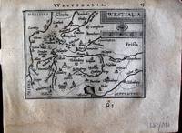
Ortelius Abraham
Westfalia. "
Europe: Antwerp Joannem Bapt. Vrientium/ Vrients. 1601. Copper engraved minature map by Phillip Galle of Westphalia Germany from" Epitome theatri Orteliani praecipuarum orbis regionum delinaetiones. . Editio ultima" Latin text to verso describing the succeeding map. . Dark impression overall toning light foxing to blank margins. Light dampstaining to blank margins. The first edition of the"Epitome" in 1577 a reduced format atlas with minature maps of Abraham Ortelius's "Theatrum" is believed to have been the initiative of the engraver Phillip Galle who asked Peter Heyns to write the text. Ortelius had fled to England in 1576 having taken refuge there from Spanish oppression and may have been unaware of the plan of his two friends. The pocket atlas was a a commmercial success and was reprinted several times with Galle adding many new maps and replacing some. Jan. Baptist Vrients bought the rights and plates of the Epitome from Phillip Galle in 1601 . he published 4 editions using the Galle plates of which this is the first with Latin text. Koeman Ort58; Phillips 413; Europe Central Europe Germany Westphalia Antwerp Joannem Bapt. Vrientium/ Vrients. 1601 unknown
Referentie van de boekhandelaar : 1369
|
|
|
Ortelius Abraham
Westphalia. "Westphaliae totius Finitimrumque Regionum Accurata Descriptio
Europe: Antverpiæ"/Antwerp. "ex Officiana Plantiana" . Plantijn Christoffel. 1595. Copper engraved map of Westphalia Germany from Ortelius' "Theatrum Orbis Terrarum" 1595 edition; black & white. Latin text to verso. Good impression; crack in plate at lower ledt corner; lightprinters ink smudges to lower area of map;rust spot to upper blank margin just outside printed area. Abraham Ortelius 1527-1598 Flemish Cartographer . produced the first modern Atlas "Theatrum Orbis Terrarum" in 1570. printed by Aegidus Coppen Diest. There were numerous editions thereafter with texts in various languages; the printing of such was taken over by Chrstoffel Plantijn in 1579 . Ortelius himself drew all the maps in manuscript before passing them to the printers. there is conjecture that he may have engraved some of the plates as well The 1595 Latin text edition is the most complete produced during his lifetime containing all the maps of the 1593 edition plus those of the the"Additamentum" and the"Pareragon" or Ancient geography. The " Additamenta" were supplements to the original Atlas; at the same time Ortelius replaced some maps with new ones showing the same place; some plates were also reworked . Ortelius was Geographer Royal To Phillip II of Spain from 1575. He also worked closely with Braun & Hogenburg on the "Civitas Orbis Terarum". After his death the plates were purchased by Jan Baptiste Vrients in 1601 who published further editions until 1612. Van de Krogt :3; .Koeman: Ort29:51 85; van.de. Broecke: 91. Europe Central Europe Germany Westphalia Antverpiæ"/Antwerp. "ex Officiana Plantiana" . Plantijn Christoffel. 1595 unknown
Referentie van de boekhandelaar : 1797

|
|
|
Ortelius Abraham
Wirtembergensis Ducatus. "Wirtenberg Ducatus
Europe: Antverpiæ"/Antwerp. "ex Officiana Plantiana" . Plantijn Christoffel. 1595. Copper engraved map of Würtenburg after Georgio Gadnero from Ortelius' "Theatrum Orbis Terrarum" 1595 edition; black & white. Latin text to verso. Good dark impression; light spot at centrefold; dampstaining to lower blank margin. Abraham Ortelius 1527-1598 Flemish Cartographer . produced the first modern Atlas "Theatrum Orbis Terrarum" in 1570. printed by Aegidus Coppen Diest. There were numerous editions thereafter with texts in various languages; the printing of such was taken over by Chrstoffel Plantijn in 1579 . Ortelius himself drew all the maps in manuscript before passing them to the printers. there is conjecture that he may have engraved some of the plates as well The 1595 Latin text edition is the most complete produced during his lifetime containing all the maps of the 1593 edition plus those of the the"Additamentum" and the"Pareragon" or Ancient geography. The " Additamenta" were supplements to the original Atlas; at the same time Ortelius replaced some maps with new ones showing the same place; some plates were also reworked . Ortelius was Geographer Royal To Phillip II of Spain from 1575. He also worked closely with Braun & Hogenburg on the "Civitas Orbis Terarum". After his death the plates were purchased by Jan Baptiste Vrients in 1601 who published further editions until 1612. Van de Krogt :3; .Koeman: Ort29: 6788; van.de. Broecke: 113. Europe Central Europe Germany Wurtenburg Wirtenberg Antverpiæ"/Antwerp. "ex Officiana Plantiana" . Plantijn Christoffel. 1595 unknown
Referentie van de boekhandelaar : 1805

|
|
|
Ortelius Abraham
Wirtenberg"
Europe: Antwerp Joannem Bapt. Vrientium/ Vrients. 1601. Copper engraved minature map by Phillip Galle of Wirtenberg Germany from" Epitome theatri Orteliani praecipuarum orbis regionum delinaetiones. . Editio ultima" Latin text to verso describing the succeeding map. . Dark impression overall toning light foxing to blank margins. The first edition of the"Epitome" in 1577 a reduced format atlas with minature maps of Abraham Ortelius's "Theatrum" is believed to have been the initiative of the engraver Phillip Galle who asked Peter Heyns to write the text. Ortelius had fled to England in 1576 having taken refuge there from Spanish oppression and may have been unaware of the plan of his two friends. The pocket atlas was a a commmercial success and was reprinted several times with Galle adding many new maps and replacing some. Jan. Baptist Vrients bought the rights and plates of the Epitome from Phillip Galle in 1601 . he published 4 editions using the Galle plates of which this is the first with Latin text. Koeman Ort58; Phillips 413; Europe Central Europe Germany Wirtenberg Antwerp Joannem Bapt. Vrientium/ Vrients. 1601 unknown
Referentie van de boekhandelaar : 1365

|
|
|
ORTELIUS Abraham
World map: Typus orbis terrarum
Antwerp: Plantin 1592. In good condition original central fold very slightly darkened. Engraved map 362 x 492 mm sheet size 465 x 590 mm; Latin text on verso; an excellent example mounted. The great cartographer Ortelius' major world map of great significance for the imagining of the Pacific and the Great Southern Land. One of the more remarkable aspects of the map is how fully it investigates the southern hemisphere mixing old speculations with the latest reports from Spanish and Portuguese voyagers in the Indian and Pacific Oceans. First published in 1570 this revision is from a slightly later Latin edition dated on the engraving 1587 but actually published around 1592 as part of Ortelius' great atlas project the Theatrum Orbis Terrarum. This updated version includes some general improvements to the geography of the globe notably some small but significant changes to the waters near Australia including the moving of New Guinea further away from the landmass of the southern land tentatively suggesting the existence of a channel to the south of the island; the newly-discovered Solomon islands are shown for the first time correctly placed to the east of New Guinea. Four added medallions contain classical quotations and the decorative clouds of the earlier edition have been replaced by a strapwork border housing the cartouches. Among other changes the southwest coastline of South America has been reconfigured more accurately. Abraham Ortelius 1527-1598 had an early career as an engraver and a book dealer but partly through the encouragement of Gerardus Mercator turned to scientific geography in the 1560s; his Theatrum Orbis Terrarum was essentially the first and certainly the most influential modern atlas. His world map was based on a much larger and extremely rare wall-map by Mercator of 1569 but the accessible format of the Ortelius version meant that it would become the map that gave currency to the theories that would dominate scientific thinking for centuries. The central premise of the map the notion of the "balancing" of the top and bottom of the globe can clearly be seen by the two polar landmasses: a series of four large islands in the north pierced by great waterways that seem to go through to the pole and much more dramatically the massive "Terra Australis Nondum Cognita" at the bottom. The Great Southern Land is enriched with a series of partly fictional landfalls and displays as a complicated synthesis of classical geography the travels of Marco Polo Beach Lucach Maletur a garbled account of what had originally been a description of parts of South America as the "kingdom of the parrots" Psittacorum Regio a completely speculative reworking of what truly lay below the southern banks of the Straits of Magellan and lastly the partial knowledge of New Guinea and the surrounding waters. Of course while it is easy to dismiss the ways in which the map is a pastiche of early travellers' tales it has been the subject of endless speculation because parts of the imagined coastline are so suggestive of parts of northern and western Australia not formally mapped until the incursions of the Dutch in the seventeenth century. Plantin unknown
Referentie van de boekhandelaar : 4504935

|
|
|
Ortelius Abraham:
Zara et Sebenic
Antwerp Johann Baptist Vrients 1601. Copper engraving 8 x 11 cms recent hand-colour waterstaining in upper margin Latin text on verso. Zara and Sebinico on the Croatian coast from the second series of maps engraved for the Epitome by Philip Galle. Koeman Ort 58 Map unknown
Referentie van de boekhandelaar : 8057
|
|
|
Ortelius Abraham
Zara et Sebenic.
<p>Balkans: Antwerp Joannem Bapt. Vrientium/ Vrients. 1601. Copper engraved minature map by Phillip Galle of the coast of Croatia around the ports of Zara and Sebinico from" Epitome theatri Orteliani praecipuarum orbis regionum delinaetiones. . Editio ultima" Latin text to verso describing the succeeding map. . Dark impression; overall toning; light foxing/staining to blank margins. The first edition of the"Epitome" in 1577 a reduced format atlas with minature maps of Abraham Ortelius's "Theatrum" is believed to have been the initiative of the engraver Phillip Galle who asked Peter Heyns to write the text. Ortelius had fled to England in 1576 having taken refuge there from Spanish oppression and may have been unaware of the plan of his two friends. The pocket atlas was a a commmercial success and was reprinted several times with Galle adding many new maps and replacing some. Jan. Baptist Vrients bought the rights and plates of the Epitome from Phillip Galle in 1601 . he published 4 editions using the Galle plates of which this is the first with Latin text. Koeman Ort58; Phillips 413; Balkans Croatia</p> Antwerp Joannem Bapt. Vrientium/ Vrients. 1601
Referentie van de boekhandelaar : 1534

|
|
|
Ortelius Abraham
Ægyptus"
Africa: Antwerp Joannem Bapt. Vrientium/ Vrients. 1601. Copper engraved minature map by Phillip Galle of Egypt from" Epitome theatri Orteliani praecipuarum orbis regionum delinaetiones. . Editio ultima" Latin text to verso describing the succeeding map. . Dark impression overall toning light dampstaining to blank margins. The first edition of the"Epitome" in 1577 a reduced format atlas with minature maps of Abraham Ortelius's "Theatrum" is believed to have been the initiative of the engraver Phillip Galle who asked Peter Heyns to write the text. Ortelius had fled to England in 1576 having taken refuge there from Spanish oppression and may have been unaware of the plan of his two friends. The pocket atlas was a a commmercial success and was reprinted several times with Galle adding many new maps and replacing some. Jan. Baptist Vrients bought the rights and plates of the Epitome from Phillip Galle in 1601 . he published 4 editions using the Galle plates of which this is the first with Latin text. Koeman Ort58; Phillips 413; Africa Egypt Antwerp Joannem Bapt. Vrientium/ Vrients. 1601 unknown
Referentie van de boekhandelaar : 1330

|
|
|
ORTELIUS Abraham
Americae Sive Novi Orbis Nova Descriptio
Abraham Ortelius 1612. unbound. very good. Map. Engraving with hand coloring. Image measures 14" x 19.25".<br/><br/> This stunning 1612 map by Abraham Ortelius depicts the Western Hemisphere. At the time it was issued the coastal areas of the New World had been fairly well explored and Europeans were just beginning settlement and colonization. It is notable for depicting Spanish and Portuguese colonies in high detail for these powers were notoriously protective of their geographical surveys.<br><br>This is the first state of the third plate engraved for Ortelius's landmark map of the New World. It is distinguished from the first two plates by the lack of the bulge to the southwest coast of South America. Several other cartographic enhancements are apparent on closer inspections.<br><br>The Solomon Islands are depicted here for the first time since their discovery in 1568 by Alvaro de Mendana. The map identifies several places previously unpublished due to political reasons. These were provided to Ortelius by Haklyut on the basis of recent explorations. The nomenclature in California is also included.<br><br>Perhaps the most notable enhancements on the east coast is the Indian name Wingandkoa and an inlet just above possibly the first depiction of the Chesapeake Bay on a printed map reflecting early English efforts at Colonization in the Outer Banks of the Carolinas. <br><br> Based on Gerard Mercators 1569 World Map this map includes an abundance of cartographic speculation representing the knowledge of the region during the time. The kingdom of Quivira the supposed ancient city of gold in North America. Conquistador Francisco Vázquez de Coronado searched for Quivira for several years to finally find it was no more than American Indian settlement of farming people. Terro del Fueggo first reached by Magellan is here shown to be part of the large speculated continent of Terra Australis that extends westward with the annotation "The southern of Magellanican land as yet unknown".<br><br>Other interesting annotations throughout include "Somewhere here there are islands which according to some have gold" and Patagonia shows a notation that suggests its inhabitants were giants.<br><br>The waters are ornamented with illustrations of ships and a sea monster. In earlier plates the ships are different. A large title cartouche is included in the bottom left. Another scale cartouche appears in the top left. Published in the 1612 or 1608 edition the map is identical in both editions of Ortelius' famous "Theatrum Orbis Terrarum" which is historically considered the first modern atlas. Based on the text on verso only 300 copies of this particular edition were ever printed van der Broecke 11. <br><br> Italian text on verso. Minor chipping to edges. Full original margins. Minor wear along original centerfold. <br><br> Abraham Ortelius 1527--1598 a Flemish cartographer and geographer is widely regarded as one of the important and influential cartographers in history. He is known for his "Theatrum Orbis Terrarum" which was the first modern atlas.<br/><br/> Abraham Ortelius unknown books
Referentie van de boekhandelaar : 219257

|
|
|
Ortelius Abraham
Angliae Scotiae et Hiberniae sive Britannica Insularum Descriptio. Double-page Map of England Scotland and Ireland with Royal Crest in upper right corner. Hand-Colored by a later hand
np 1590. Image area 19 1/2 x 13 1/2 inches in 28 x 23 inch mat. Single crease down center with one 1/2 inch spot worn through otherwise a nice handsome map. Image area 19 1/2 x 13 1/2 inches in 28 x 23 inch mat. Abraham Ortelius 1527-1598 was a Flemish geographer of German origin. His major work Theatrum Orbis Terrarum 1570 with later revisions and addenda was the first modern atlas. It was based on contemporary charts and maps and contained a collection of plates engraved by Franz Hagenberg in a uniform size and format. The Theatrum preceded the first Atlas of Ortelius' good friend Gerardus Mercator. In fact popular and sentimental legend has it that Mercator delayed publication of his own work so that his younger friend's would appear first. although this simply is not true Mercator wasn't ready the legendary cartographer did compliment Ortelius for the "care and elegance" he put into his "Theatrum. unknown books
Referentie van de boekhandelaar : 37978
|
|
|
ORTELIUS Abraham
Circulus sive Liga Sveviae
Antwerp 1612. Tape reinforcements along edge on verso without show-through and not affecting image a few foxmarks overall in very good condition with good color. Hand colored engraved map 12 5/8 x 9 7/8 inches image 16 1/2 x 10 5/8 inches sheet. Crossed arrows watermark. A fine map from Ortelius's atlas showing Lake Constance the Danube and Rhine. Bounded by the Lech Odenwald Alsace and Chur in Switzerland. <br/><br/> unknown books
Referentie van de boekhandelaar : 406876

|
|
|
ORTELIUS Abraham
Culiacanae Americae Regionis Descriptio / Hispaniolae Cubae Aliarumque Insularum Circumiacientium Delineatio
Antwerp: Abraham Ortelius 1587. unbound. Map. Uncolored engraving. Image measures 14" x 19.5".<br/><br/> These two maps on one sheet detail areas of western Mexico above and the Greater Antilles below. Ortelius created them from information compiled by other mapmakers such as Mercator Guttierez and Alsons de Sata Cruz. These sources allowed him to include a wealth of detailed information that is mostly if not entirely accurate. Above the map of western Mexico shows the area around Culiacan and the Spanish settlement of Villa S. Michaels which was notable in the period for its silver mines. It begins at the Yucatan and extends through the Cayman Magnus and the Caymanes. The map below illustrates the Greater Antilles including Cuba Hispaniola Jamaica St. Jois Insula St. Johns the Bahamas Virgin Islands and the Windward Islands all in impressive detail. The section of South Florida also shows suggestion of the Florida Keys which was uncommon for these period. A notable error is that the Tropic of Cancer is labelled as the Tropic of Capricorn. A highly decorative note with strapwork and foliage fills the acific Ocean to the left of Mexico and provides information about the upper map. The lower map also has a framed cartouche with birds perched atop it. Two ship illustrations float in the choppy seas around the islands. The map is a first state from the 1587 French edition of Ortelius's "Theatrum Orbis Terrarum." It is in good condition with no chips or tears. Stain at the center seam in the lower margin not affecting the image some overall stains. French text on verso. Abraham Ortelius 1527--1598 a Flemish cartographer and geographer is widely regarded as one of the important and influential cartographers in history. He is known for his "Theatrum Orbis Terrarum" which was the first modern atlas. This map is an uncommon uncolored example of this wonderful map by Ortelius.<br/><br/> Abraham Ortelius unknown books
Referentie van de boekhandelaar : 239611

|
|
|
ORTELIUS Abraham
Fori Iulii Accurata Descriptio; An Accurate description of Friuli
Antwerp: Abraham Ortelius 1603. unbound. Map. Engraving with hand coloring Image measures 14" x 18 3/4". Staining toning and chips to margins but otherwise is good condition.<br/><br/> Friuli is the northeast Italian region bordering Austria Slovenia and the Adriatic Sea. It's home to the sharp-peaked Dolomite Mountains and vineyards producing white wines. Ortelius' 1603 edition extends from Venice north to the Italian Alps and east to Trieste and Istria. Lovely depiction of Venice floating on several islands. Abraham Ortelius 1527--1598 a Flemish cartographer and geographer is widely regarded as one of the important and influential cartographers in history. He is known for his "Theatrum Orbis Terrarum" which was the first modern atlas. Van Den Broecke 119<br/><br/> Abraham Ortelius unknown books
Referentie van de boekhandelaar : 299083

|
|
|
ORTELIUS Abraham
Galliae Regni Potentiss: Nova Descriptio
Antwerp: Abraham Ortelius 1603. unbound. Map. Engraving with beautiful original hand color. Image measures 14" x 18 3/4". Staining and toning repair to margins but otherwise is good condition.<br/><br/> Old color example of this lovely map of 16th c. France by Ortelius. Abraham Ortelius 1527-1598 a Flemish cartographer and geographer is widely regarded as one of the important and influential cartographers in history. He is known for his "Theatrum Orbis Terrarum" which was the first modern atlas. Van den Broecke #34<br/><br/> Abraham Ortelius unknown books
Referentie van de boekhandelaar : 299305

|
|
|
ORTELIUS Abraham
Hollandiae Antiquorum Catthorum Sedis Nova Descriptio
Antwerp: Abraham Ortelius 1592. unbound. Map. Uncolored engraving. Sheet measures 16" x 21".<br/><br/> This beautiful 1588 map by Abraham Ortelius depicts Holland or the Netherlands in exceptional detail. The map covers the regions near the Wadden Sea roughly covering modern day provinces of North Holland South Holland and Utrecht. The map centered on Amsterdam is oriented with north to the left. Topographical and geographical features such as mountains and cities are beautifully rendered in profile.<br><br>The waters surrounding the region are shown with waves and include several illustrations of ships throughout. This is the first state of the map with later states showing a stippled sea rather than waves. Includes a large strapwork title cartouche scale of miles with a divider in the lower left. The Royal coat of arms is presented in the top left. The map also includes a 16-point compass rose.<br><br>Ortelius based this map on the work of Jacob van Daventer. Published in the 1588 edition of Ortelius' famous "Theatrum Orbis Terrarum" which is historically considered the first modern atlas. Based on the text on verso only 300 copies of this particular edition were ever printed van der Broecke 79.<br><br>The map is in good condition with minor wear along the original centerfold. Minor foxing at places. Original plate mark is visible. Latin text on verso.<br><br> Abraham Ortelius 1527--1598 a Flemish cartographer and geographer is widely regarded as one of the important and influential cartographers in history. He is known for his "Theatrum Orbis Terrarum" which was the first modern atlas. Hard to find in black and white.<br/><br/> Abraham Ortelius unknown books
Referentie van de boekhandelaar : 273298

|
|
|
ORTELIUS Abraham
Insularum Aliquot Maris Mediterranei Descriptio; Sicily Malta Sardinia Corfu Elba and Zerbia
Antwerp: Abraham Ortelius 1603. unbound. Map. Engraving with beautiful original hand color. Image measures 14" x 18 3/4". Light staining and toning but otherwise is good condition.<br/><br/> A representation of some islands in the Mediterranean Sea. Abraham Ortelius 1527-1598 a Flemish cartographer and geographer is widely regarded as one of the important and influential cartographers in history. He is known for his "Theatrum Orbis Terrarum" which was the first modern atlas. Van den Broecke #141<br/><br/> Abraham Ortelius unknown books
Referentie van de boekhandelaar : 299306

|
|
 De zoekresultaten per email ontvangen
 Zoekresultaten downloaden als PDF
 RSS feed


