|
Menzel R
Adam schuf die Erde neu
Duesseldorf: Econ. Abb. Tesafilmspuren auf Vorderdeckel innen Econ unknown
Bookseller reference : 36516
|
|
|
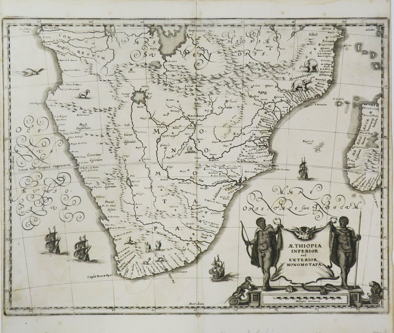
MERIAN (Matthäus).
[AFRIQUE MERIDIONALE] Æthiopia inferior vel exterior Monomotapa.
[1649]. 286 x 373 mm.
Bookseller reference : LBW-3606
|
|
|
MERCATOR (Gerard) & HONDIUS (Jodocus).
[ETHIOPIE] Abissinorum regnu.
[Dordrecht, Adrianus Bottius, 1610]. 142 x 178 mm.
Bookseller reference : LBW06151

|
|
|
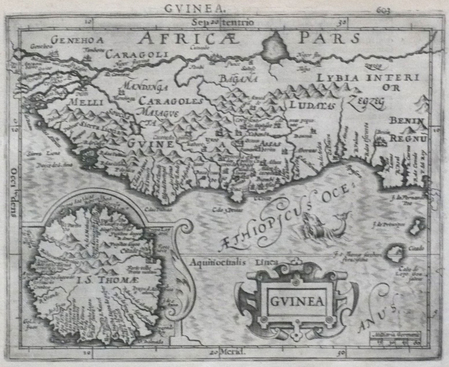
MERCATOR (Gerard) & HONDIUS (Jodocus).
[GUINEE] Guinea.
[Dordrecht, Adrianus Bottius, 1610]. 150 x 183 mm.
Bookseller reference : LBW06150
|
|
|
Merriam Charles Edward
A History of American Political Theories (Large Text Classic Reprint)
Forgotten Books 2018 384 pages 10 4x15 2x0 8cm. 2018. Broché. 384 pages.
Bookseller reference : 500094846

|
|
|
Mercier (Paul)
Cartes ethno-démographiques de l'Afrique Occidentale, Feuilles 5.
1955 1955 IFAN, Dakar, 1955. 2 cartes dépliantes en deux feuilles chacune. 1chemise in-4. Bel exemplaire malgré rousseurs. Bibliothèque de Z. Ligers.
Bookseller reference : 939
|
|
|
MERCIER, E.
Comment l’Afrique Septentrionale a été arabisée. Extrait résumé de L’histoire de l’établissement des arabes dans l’Afrique Septentrionale.
Constantine, Impr. L. Marle 1874, 240x165mm, 18pages, broché. Couvertures manquantes.
Bookseller reference : 49682

|
|
|
MERLIN Pierre - Jacques Delors (préface de)
Espoir pour l'Afrique Noire
1991 Présence Africaine, A.C.C.T. - 1991 - In-8 broché - 477 pages - quelques reproductions photographiques
Bookseller reference : 100429
|
|
|
MERCIER P. .
INITIATIONS AFRICAINES - LES TÂCHES DE LA SOCIOLOGIE .
Institut Français d'Afrique Noire, Dakar, 1951, bibliographie, tableaux et diagrammes dans le texte, brochure agrafée de 93pp. bon état, 245x158 . (p2)
Bookseller reference : 8152
|
|
|
MERCIER André
Je suis un assassin
Amiot Dumont Paris, Amiot Dumont, 1954. In-8 carré broché couverture illustrée de 192 pages. Photos en noir hors texte. Bandeau conservé. Très bon état
Bookseller reference : 22566
|
|
|
MERCIER André
JE SUIS UN ASSASSIN
Amiot Dumont Amiot Dumont 1954, In-8 relié demi basane blonde à coins, couverture conservée. 192 pages + photos. Bon état.
Bookseller reference : 99929816
|
|
|
mercier
l'afrique a travers ses fils
lib orientaliste 1944 reliure souple non coupee 265 pages
Bookseller reference : d178
|
|
|
MERLE (Marcel)(dir.).
L'Afrique noire contemporaine.
Armand Colin, 1968, gr. in-8°, 456 pp, 16 figures, 3 cartes, documents, biblio, reliure de l'éditeur, bon état (Coll. U)
Bookseller reference : 74807
|
|
|
Mercier - Massé - Hauser
L'Agglomération Dakaroise - Quelques Aspects Sociologiques et Démographiques
Dakar, 1954, in-8, 83pp, broché, Superbe exemplaire, très bel envoi de l'auteur adressé à Marcel Griaule! 83pp
Bookseller reference : 67401
|
|
|
Merle Marcel
L'Afrique noire contemporaine
Librairie Armand Colin Collection U Cartonné 1968 In-8 (17,5 x 23,5 cm), cartonné, 455 pages ; volume bruni, incidents et brunissures sur les plats, état moyen. Livraison a domicile (La Poste) ou en Mondial Relay sur simple demande.
Bookseller reference : ve284

|
|
|
MERCIER (Roger)
L'Afrique noire dans la littérature française. Les premières images (XVIIe - XVIIIe siècles).
Dakar, Publications de la section de langes et littérature, 1962. In-8 broché, 242 pp., bibliographie.
Bookseller reference : 593841

|
|
|
MERCIER (Ernest) & collectif
L'Afrique à travers ses fils
Paris, Librairie Orientaliste Paul Geuthner, 1944. In-8 broché, 268 p. Préface de Jérôme Carcopino. 5 planches h.-t. Très bon état (qq. rousseurs).L'auteur : Historien de l'Afrique septentrionale, maire de Constantine.
Bookseller reference : 8022
|
|
|
MERAND, Patrick.
La Vie quotidienne en Afrique noire a travers la litterature africaine.
Paris, L"Harmattan, 1977. in-8°, 239 pp, tabl., biblio, broche, couverture illustree.
Bookseller reference : 19678
|
|
|
MERMEIX
Le Transvaal et la Chartered
P. Ollendorff, Paris 1897, 12x19cm, broché.
Bookseller reference : 12159
|
|
|
MEREGAZZI Renzo
LINEAMENTI DELLA LEGISLAZIONE PER L'IMPERO.
Estratto da Gli Annali dell'Africa Italiana. Mondadori, Milano, 1939. In-8 gr., bross., pp. 160,(2), con 1 tavola fuori testo pi volte ripiegata raffigurante l'organigramma del Ministero dell'Africa Italiana. In buono stato (good copy).
Bookseller reference : 46319
|
|
|
MERAB (Docteur)
Médecins et Médecine en Ethiopie
P., VIgot Frères, 1912. In-8 br., 218 pp, ex. non-coupé. Étiquette d'éditeur.
Bookseller reference : 562008

|
|
|
MERVELEC Patrick (de)
Regards sur l'Afrique du sud.
Nouveau Monde, Paris, 1996. In-4 relié avec jaquette imprimée ( 30 x 25 cm) 137 pages. Très nombreuses illustrations hors-texte. Reliure éditeur et jaquette illustrée. État : Parfait état.
Bookseller reference : 18688

|
|
|
MERCIER (André).-
Route sauvage. Le raid Le Cap-Alger-Paris.
P., Amiot-Dumont, 1952, in 8° broché, 254 pages ; illustrations ; cachets.
Bookseller reference : 37287
|
|
|
MERCER GRAHAM
TANZANIE / COLLECTION BON VOYAGE - GUIDE ET CARTE
KONEMANN. 1999. In-12. Broché. Etat d'usage, Couv. convenable, Dos satisfaisant, Intérieur frais. 128 pages - nombreuses photos et cartes couleur dans le texte - plats contrepliés - + 1 carte dépliante couleur échelle 1 : 1.900.000, 70 x 75 cm environ. . . . Classification Dewey : 967-Afrique centrale
Bookseller reference : R240124274
|
|
|
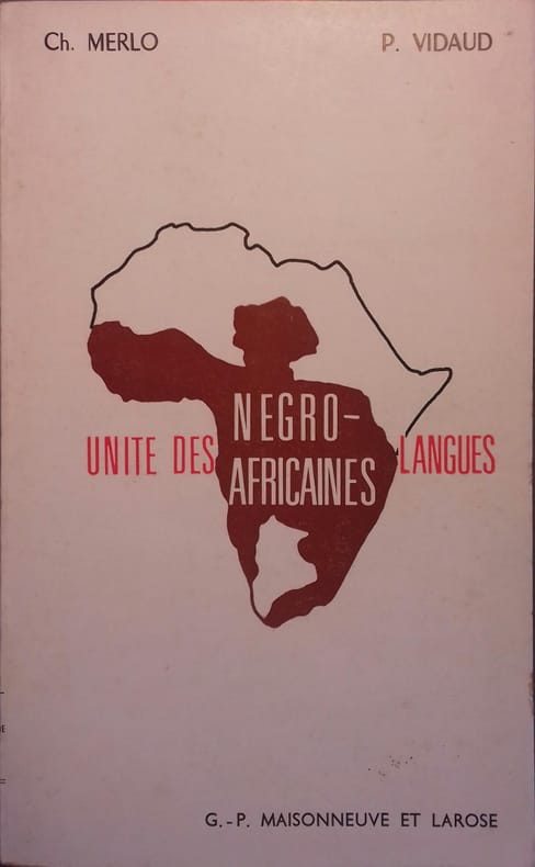
MERLO Christian - VIDAUD Pierre
Unité des langues négro-africaines.
Couverture souple. Broché. 169 pages.
Bookseller reference : 34852
|
|
|
MERLO Christian - VIDAUD Pierre
Unité des langues négro-africaines.
Couverture souple. Broché. 169 pages.
Bookseller reference : 34853

|
|
|
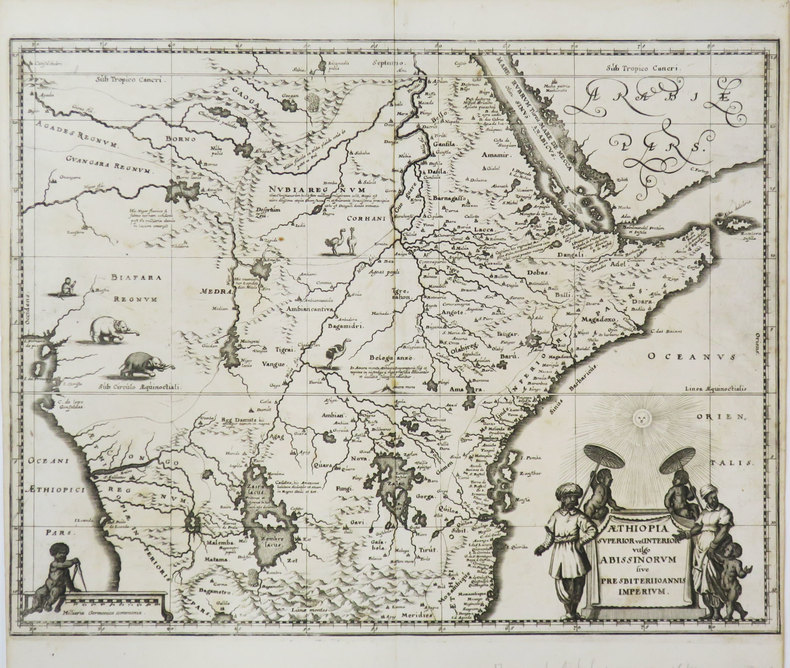
MERIAN (Matthäus).
Æthiopia superior vel interior vulgo Abissinorum sive Presbiteri Joannis imperium.
[1649]. 287 x 373 mm.
Bookseller reference : LBW-3605
|
|
|
MERAND Patrick
La vie quotidienne en Afrique Noire. A travers la littérature africaine.
Broché. 240 pages.
|
|
|
MERAND Patrick.
La vie quotidienne en Afrique Noire à travers la littérature africaine.
in-8°, pp. 240 con una mappa n.t. Bross. edit. figurata. Tracce del tempo e d'uso sui piatti. Rare segnature a matita all'interno.
|
|
|
MERAND, Patrick.
La Vie quotidienne en Afrique noire a travers la litterature africaine.
in-8°, 239 pp, tabl., biblio, broche, couverture illustree. Bel exemplaire [CA28-3]
|
|
|
Meras I
Die Mondwoche
Kultur u. Fortschritt. Umschlag beschaedigt Vorsatz gebraeunt Kultur u. Fortschritt unknown
Bookseller reference : 24435
|
|
|
Meras Mathieu
Chateaux de France
Nathan Pays Et Cites D'Art 1970-01-01. Hardcover. Good/No Jacket. French language. Langue Francaise. Robust recyclable packaging. 1st class post to the UK Airmail worldwide Nathan Pays Et Cites D'Art hardcover
Bookseller reference : 168156

|
|
|
Merbold Uua
D1 Unser Weg ins All
Braunschweig: Westermann 1985. Abb. 22 x 28 cm Westermann unknown
Bookseller reference : 41522
|
|
|
Mercatali Enrico
Tripoli - Cirenaica. Note descrittive, illustrate, dei paesi, dei costumi, della storia libica, alternate con le cronache della guerra italo turca e della conquista della Libia seguite dalla rassegna della guerra balcanica
2 vol. in 4°, pp. XXIV+1008. Legatura in mz pelle con piatti originali dove sono applicate le brossure policrome dell'opera. Fotografie in nero nel testo. Non comune.

|
|
|
MERCATELLI Luigi -
Gli ultimi avvenimenti d'Africa.
Milano, 1895, febbraio 17, bella copertina litografica illustrata a colori in fascicolo originale completo di pp. 8 De “La Tribuna – Supplemento illustrato della Domenica”

|
|
|
MERCATOR (Kremer) Gerard (1512 - 1594)
Abissinorum Sive Pretiosi Ioannis Imperiu
La carta viene preparata da Gerard Mercator per l’Atlantis Pars Altera (1595) pubblicato postumo alla morte dell’autore, sotto la supervisione del figlio Rumold Mercator, dallo stampatore di Duisburg Albert Buys. Composto da sei parti – pubblicate separatamente tra il 1589 e il 1594 – comprende 107 mappe, tutte tranne la carta del mondo di Rumold, firmate da Gerard Mercator. Le lastre vennero poi acquistate da Jodocus Hondius, che tra il 1606 e il 1630 le utilizzò per il suo Atlas Sive Cosmographicae Meditationes de Fabrica Mundi, integrandole ed aggiornandole con proprie “nuove” carte. Delle mappe di Mercator sono note anche ristampe curate da Johannes Janssonius. Le edizioni Hondius e Janssonius ebbero un grande successo commerciale e furono stampate in più lingue, con il testo al verso della carta in latino, francese, tedesco e olandese. La carta è incisa con i connotati tipici dell'opera mercatoriana. Le montagne sono allineate in un concetto di area montuosa, non per indicare vere catene o valli, ed hanno una struttura con qualche differenza nella dimensione, ma simile per quanto riguarda la forma, con pendici verticali e cime piatte. Le città sono mostrate attraverso castelli più o meno grandi caratterizzati da tetti slanciati ed aguzzi, simili a cappelli di mago. Esemplare tratto da Atlas Sive Cosmographicae Meditationes de Fabrica Mundi di Jodocus Hondius. Incisione in rame, in buono stato di conservazione. Bibliografia cfr. Koeman II Me 11 e Koeman II Me 13A, 1595); Van der Krogt 1:002; J. Keuning, The History of an Atlas, in “Imago Mundi” IV (1947) pp. 37-43; World Encompassed p. 134. The map is prepared by Gerard Mercator for his Atlantis Pars Altera (1595) published posthumously after the death of Mercator, by the Duisburg printer Albert Buys, under the supervision of his son Rumold Mercator. Composed of six parts - published separately between 1589 and 1594 - it includes 107 maps, all except Rumold's map of the world, made by Gerard Mercator. The plates were then purchased by Jodocus Hondius, who between 1606 and 1630 used them for his Atlas Sive Cosmographicae Meditationes de Fabrica Mundi, integrating and updating them with his own "new" maps. Of Mercator's maps are also known reprints edited by Johannes Janssonius. The Hondius and Janssonius editions had a great commercial success and were printed in several languages, with the text on the back of the map in Latin, French, German and Dutch. The map is engraved with the typical connotations of Mercatorian work. The mountains are aligned in a mountainous area concept, not to indicate true chains or valleys, and have a structure with some differences in size, but similar in shape, with vertical slopes and flat tops. The cities are shown through more or less large castles characterized by slender and pointed roofs, similar to wizard hats. Example from Atlas Sive Cosmographicae Meditationes de Fabrica Mundi by Jodocus Hondius. Copper engraving, in good condition. Bibliografia cfr. Koeman II Me 11 e Koeman II Me 13A, 1595); Van der Krogt 1:002; J. Keuning, The History of an Atlas, in “Imago Mundi” IV (1947) pp. 37-43; World Encompassed p. 134.

|
|
|
MERCATOR (Kremer) Gerard (1512 - 1594)
AFR: III TAB : (Africae Tabula Tertia)
Mappa tratta dal Cl. Ptolemaei Alexandrini, Geographiae Libri Octo, pubblicata prima a Colonia da Gottfried von Kempen (1578) e poi ristampata dallo stesso editore nel 1584 (Van der Krogt 1, 502) e poi da Isaac Elsevier per il Theatrum Geographiae veteris di Petrus Bertius (Leyden 1618). Di tutte le edizioni di Tolomeo, quella di Gerard Kremer (Mercatore), pubblicata nel 1578, e forse tecnicamente la più bella. A questo punto la Geografia di Tolomeo perdeva però ogni pretesa di “attualità”, laddove lo scopo di Mercatore era quello di produrre un atlante del mondo classico che servisse da complemento al suo atlante moderno (per tale ragione egli aveva tentato di recuperare la forma originale dell’atlante tolemaico, scartandone le moderne accrezioni). L'interpretazione di Mercatore del testo tolemaico, per le 28 carte che illustrano la sua Geographia è stata, quindi, una delle più veritiere. Egli aveva passato 13 anni a ricercare, disegnare e incidere le carte, rinunciando anche alla pubblicazione delle sue carte “moderne”. Questo esemplare proviene dal Theatrum Geographia Veteris di Petrus Bertius edita a Leida nel 1618, che combina il Tolomeo di Mercator, le 8 tavole del Moretus per rappresentare la Tabula Peutingeriana e 14 mappe storiche delle regioni d'Europa derivate dal Parergon di Ortelius. Acquaforte su rame, in buone condizioni. Map taken from the Cl. Ptolemaei Alexandrini, Geographiae Libri Octo, first published in Cologne by Gottfried von Kempen (1578) and then reprinted by the same publisher in 1584 (Van der Krogt 1, 502) and then by Isaac Elsevier for the Petrus Bertius’ Theatrum Geographiae veteris (Leyden 1618). Mercator's interpretation of the 28 Ptolemaic text was possibly one of the truest undertaken up until that time. He had spent 13 years researching, drawing and engraving the maps at much commercial sacrifice to himself, having seen Ortelius's Theatrum and De Jodes Speculum published, to become both technical and commercial successes. In later life he devoted himself to his edition of the maps in Ptolemy's Geographia, reproduced in his own engraving as nearly as possible in their original form. This example comes from the Theatrum Geographia Veteris of Petrus Bertius published in Leiden in 1618, which combines Mercator's Ptolemy, the 8 plates of Moretus to represent the Tabula Peutingeriana and 14 historical maps of the regions of Europe derived from the Parergon of Ortelius. Copperplate, in good condition.

|
|
|
MERCATOR (Kremer) Gerard (1512 - 1594)
Appendix Tab.III Africae, Aegyptum Inferiorem Exhibens
Mappa tolemaica della regione, originalmente preparata per illustrare il Cl. Ptolemaei Alexandrini, Geographiae Libri Octo, pubblicato prima a Colonia da Gottfried von Kempen (1578), ristampato dallo stesso editore nel 1584 (Van der Krogt 1, 502) e poi da Isaac Elsevier per il Theatrum Geographiae veteris di Petrus Bertius (Leyden 1618). Di tutte le edizioni di Tolomeo, quella di Gerard Kremer (Mercatore), pubblicata nel 1578, e forse tecnicamente la più bella. A questo punto la Geografia di Tolomeo perdeva pero ogni pretesa di “attualità”, laddove lo scopo di Mercatore era quello di produrre un atlante del mondo classico che servisse da complemento al suo atlante moderno (per tale ragione egli aveva tentato di recuperare la forma originale dell’atlante tolemaico, scartandone le moderne accrezioni). L’opera è celebre anche per la sua longevità, poiché le lastre originali risultavano ancora in uso nel 1730, oltre centocinquanta anni dopo la loro incisione. Esemplare tratto dalla Tabulae geographicae Cl: Ptolemei di François Halma, stampata tra Utrecht, Amsterdam e Leida nel 1695, 1698, 1704 (2 tirature) e 1730.Le lastre sono emendate e i cartigli completamenti cambiati; più piccoli e realizzati sopra i precedenti – abrasi – lasciando ampie aree bianche sulla stampa. Acquaforte su rame, in buone condizioni. Ptolemaic map prepared for the Cl. Ptolemaei Alexandrini, Geographiae Libri Octo, first published in Cologne by Gottfried von Kempen (1578) and then reprinted by the same publisher in 1584 (Van der Krogt 1, 502) and then by Isaac Elsevier for the Petrus Bertius’ Theatrum Geographiae veteris (Leyden 1618). Mercator's interpretation of the 28 Ptolemaic text was possibly one of the truest undertaken up until that time. He had spent 13 years researching, drawing and engraving the maps at much commercial sacrifice to himself, having seen Ortelius's Theatrum and De Jodes Speculum published, to become both technical and commercial successes. In later life he devoted himself to his edition of the maps in Ptolemy's Geographia, reproduced in his own engraving as nearly as possible in their original form. The work is also famous for its longevity, since the original plates were still in use in 1730, over one hundred and fifty years after their engraving. Example taken from the Tabulae geographicae Cl: Ptolemei by François Halma, printed between Utrecht, Amsterdam and Leiden in 1695, 1698, 1704 (2 printings) and 1730. The plates are amended and the cartouches completely changed; smaller and made over the previous ones - erased - leaving large white areas on the print. Copperplate, good condition.

|
|
|
MERCATOR (Kremer) Gerard (1512 - 1594)
Tab.I Africae, in qua Mauritania Tingitana et Caesariensis…
Mappa tolemaica della regione, originalmente preparata per illustrare il Cl. Ptolemaei Alexandrini, Geographiae Libri Octo, pubblicato prima a Colonia da Gottfried von Kempen (1578), ristampato dallo stesso editore nel 1584 (Van der Krogt 1, 502) e poi da Isaac Elsevier per il Theatrum Geographiae veteris di Petrus Bertius (Leyden 1618). Di tutte le edizioni di Tolomeo, quella di Gerard Kremer (Mercatore), pubblicata nel 1578, e forse tecnicamente la più bella. A questo punto la Geografia di Tolomeo perdeva pero ogni pretesa di “attualità”, laddove lo scopo di Mercatore era quello di produrre un atlante del mondo classico che servisse da complemento al suo atlante moderno (per tale ragione egli aveva tentato di recuperare la forma originale dell’atlante tolemaico, scartandone le moderne accrezioni). L’opera è celebre anche per la sua longevità, poiché le lastre originali risultavano ancora in uso nel 1730, oltre centocinquanta anni dopo la loro incisione. Esemplare tratto dalla Tabulae geographicae Cl: Ptolemei di François Halma, stampata tra Utrecht, Amsterdam e Leida nel 1695, 1698, 1704 (2 tirature) e 1730.Le lastre sono emendate e i cartigli completamenti cambiati; più piccoli e realizzati sopra i precedenti – abrasi – lasciando ampie aree bianche sulla stampa. Acquaforte su rame, in buone condizioni. Ptolemaic map prepared for the Cl. Ptolemaei Alexandrini, Geographiae Libri Octo, first published in Cologne by Gottfried von Kempen (1578) and then reprinted by the same publisher in 1584 (Van der Krogt 1, 502) and then by Isaac Elsevier for the Petrus Bertius’ Theatrum Geographiae veteris (Leyden 1618). Mercator's interpretation of the 28 Ptolemaic text was possibly one of the truest undertaken up until that time. He had spent 13 years researching, drawing and engraving the maps at much commercial sacrifice to himself, having seen Ortelius's Theatrum and De Jodes Speculum published, to become both technical and commercial successes. In later life he devoted himself to his edition of the maps in Ptolemy's Geographia, reproduced in his own engraving as nearly as possible in their original form. The work is also famous for its longevity, since the original plates were still in use in 1730, over one hundred and fifty years after their engraving. Example taken from the Tabulae geographicae Cl: Ptolemei by François Halma, printed between Utrecht, Amsterdam and Leiden in 1695, 1698, 1704 (2 printings) and 1730. The plates are amended and the cartouches completely changed; smaller and made over the previous ones - erased - leaving large white areas on the print. Copperplate, good condition.

|
|
|
MERCATOR (Kremer) Gerard (1512 - 1594)
Tab.II. Africae, Complectens Africam Proprie dictam
Mappa tolemaica della regione, originalmente preparata per illustrare il Cl. Ptolemaei Alexandrini, Geographiae Libri Octo, pubblicato prima a Colonia da Gottfried von Kempen (1578), ristampato dallo stesso editore nel 1584 (Van der Krogt 1, 502) e poi da Isaac Elsevier per il Theatrum Geographiae veteris di Petrus Bertius (Leyden 1618). Di tutte le edizioni di Tolomeo, quella di Gerard Kremer (Mercatore), pubblicata nel 1578, e forse tecnicamente la più bella. A questo punto la Geografia di Tolomeo perdeva pero ogni pretesa di “attualità”, laddove lo scopo di Mercatore era quello di produrre un atlante del mondo classico che servisse da complemento al suo atlante moderno (per tale ragione egli aveva tentato di recuperare la forma originale dell’atlante tolemaico, scartandone le moderne accrezioni). L’opera è celebre anche per la sua longevità, poiché le lastre originali risultavano ancora in uso nel 1730, oltre centocinquanta anni dopo la loro incisione. Esemplare tratto dalla Tabulae geographicae Cl: Ptolemei di François Halma, stampata tra Utrecht, Amsterdam e Leida nel 1695, 1698, 1704 (2 tirature) e 1730.Le lastre sono emendate e i cartigli completamenti cambiati; più piccoli e realizzati sopra i precedenti – abrasi – lasciando ampie aree bianche sulla stampa. Acquaforte su rame, in buone condizioni.. Ptolemaic map prepared for the Cl. Ptolemaei Alexandrini, Geographiae Libri Octo, first published in Cologne by Gottfried von Kempen (1578) and then reprinted by the same publisher in 1584 (Van der Krogt 1, 502) and then by Isaac Elsevier for the Petrus Bertius’ Theatrum Geographiae veteris (Leyden 1618). Mercator's interpretation of the 28 Ptolemaic text was possibly one of the truest undertaken up until that time. He had spent 13 years researching, drawing and engraving the maps at much commercial sacrifice to himself, having seen Ortelius's Theatrum and De Jodes Speculum published, to become both technical and commercial successes. In later life he devoted himself to his edition of the maps in Ptolemy's Geographia, reproduced in his own engraving as nearly as possible in their original form. The work is also famous for its longevity, since the original plates were still in use in 1730, over one hundred and fifty years after their engraving. Example taken from the Tabulae geographicae Cl: Ptolemei by François Halma, printed between Utrecht, Amsterdam and Leiden in 1695, 1698, 1704 (2 printings) and 1730. The plates are amended and the cartouches completely changed; smaller and made over the previous ones - erased - leaving large white areas on the print. Copperplate, good condition.

|
|
|
MERCATOR (Kremer) Gerard (1512 - 1594)
Tab.III Africae, in qua Cyrenaica, Marmarica, ac Lybia Exterior..
Mappa tolemaica della regione, originalmente preparata per illustrare il Cl. Ptolemaei Alexandrini, Geographiae Libri Octo, pubblicato prima a Colonia da Gottfried von Kempen (1578), ristampato dallo stesso editore nel 1584 (Van der Krogt 1, 502) e poi da Isaac Elsevier per il Theatrum Geographiae veteris di Petrus Bertius (Leyden 1618). Di tutte le edizioni di Tolomeo, quella di Gerard Kremer (Mercatore), pubblicata nel 1578, e forse tecnicamente la più bella. A questo punto la Geografia di Tolomeo perdeva pero ogni pretesa di “attualità”, laddove lo scopo di Mercatore era quello di produrre un atlante del mondo classico che servisse da complemento al suo atlante moderno (per tale ragione egli aveva tentato di recuperare la forma originale dell’atlante tolemaico, scartandone le moderne accrezioni). L’opera è celebre anche per la sua longevità, poiché le lastre originali risultavano ancora in uso nel 1730, oltre centocinquanta anni dopo la loro incisione. Esemplare tratto dalla Tabulae geographicae Cl: Ptolemei di François Halma, stampata tra Utrecht, Amsterdam e Leida nel 1695, 1698, 1704 (2 tirature) e 1730.Le lastre sono emendate e i cartigli completamenti cambiati; più piccoli e realizzati sopra i precedenti – abrasi – lasciando ampie aree bianche sulla stampa. Acquaforte su rame, in buone condizioni. Ptolemaic map prepared for the Cl. Ptolemaei Alexandrini, Geographiae Libri Octo, first published in Cologne by Gottfried von Kempen (1578) and then reprinted by the same publisher in 1584 (Van der Krogt 1, 502) and then by Isaac Elsevier for the Petrus Bertius’ Theatrum Geographiae veteris (Leyden 1618). Mercator's interpretation of the 28 Ptolemaic text was possibly one of the truest undertaken up until that time. He had spent 13 years researching, drawing and engraving the maps at much commercial sacrifice to himself, having seen Ortelius's Theatrum and De Jodes Speculum published, to become both technical and commercial successes. In later life he devoted himself to his edition of the maps in Ptolemy's Geographia, reproduced in his own engraving as nearly as possible in their original form. The work is also famous for its longevity, since the original plates were still in use in 1730, over one hundred and fifty years after their engraving. Example taken from the Tabulae geographicae Cl: Ptolemei by François Halma, printed between Utrecht, Amsterdam and Leiden in 1695, 1698, 1704 (2 printings) and 1730. The plates are amended and the cartouches completely changed; smaller and made over the previous ones - erased - leaving large white areas on the print. Copperplate, good condition.

|
|
|
MERCATOR (Kremer) Gerard (1512 - 1594)
Tab.IV Africae in qua Libya Interior et Exterior.Aethiopia..
Mappa tolemaica della regione, originalmente preparata per illustrare il Cl. Ptolemaei Alexandrini, Geographiae Libri Octo, pubblicato prima a Colonia da Gottfried von Kempen (1578), ristampato dallo stesso editore nel 1584 (Van der Krogt 1, 502) e poi da Isaac Elsevier per il Theatrum Geographiae veteris di Petrus Bertius (Leyden 1618). Di tutte le edizioni di Tolomeo, quella di Gerard Kremer (Mercatore), pubblicata nel 1578, e forse tecnicamente la più bella. A questo punto la Geografia di Tolomeo perdeva pero ogni pretesa di “attualità”, laddove lo scopo di Mercatore era quello di produrre un atlante del mondo classico che servisse da complemento al suo atlante moderno (per tale ragione egli aveva tentato di recuperare la forma originale dell’atlante tolemaico, scartandone le moderne accrezioni). L’opera è celebre anche per la sua longevità, poiché le lastre originali risultavano ancora in uso nel 1730, oltre centocinquanta anni dopo la loro incisione. Esemplare tratto dalla Tabulae geographicae Cl: Ptolemei di François Halma, stampata tra Utrecht, Amsterdam e Leida nel 1695, 1698, 1704 (2 tirature) e 1730.Le lastre sono emendate e i cartigli completamenti cambiati; più piccoli e realizzati sopra i precedenti – abrasi – lasciando ampie aree bianche sulla stampa. Acquaforte su rame, in buone condizioni. Ptolemaic map prepared for the Cl. Ptolemaei Alexandrini, Geographiae Libri Octo, first published in Cologne by Gottfried von Kempen (1578) and then reprinted by the same publisher in 1584 (Van der Krogt 1, 502) and then by Isaac Elsevier for the Petrus Bertius’ Theatrum Geographiae veteris (Leyden 1618). Mercator's interpretation of the 28 Ptolemaic text was possibly one of the truest undertaken up until that time. He had spent 13 years researching, drawing and engraving the maps at much commercial sacrifice to himself, having seen Ortelius's Theatrum and De Jodes Speculum published, to become both technical and commercial successes. In later life he devoted himself to his edition of the maps in Ptolemy's Geographia, reproduced in his own engraving as nearly as possible in their original form. The work is also famous for its longevity, since the original plates were still in use in 1730, over one hundred and fifty years after their engraving. Example taken from the Tabulae geographicae Cl: Ptolemei by François Halma, printed between Utrecht, Amsterdam and Leiden in 1695, 1698, 1704 (2 printings) and 1730. The plates are amended and the cartouches completely changed; smaller and made over the previous ones - erased - leaving large white areas on the print. Copperplate, good condition.

|
|
|
Mercer Charles
Promise Morning.
New York Putnams 1966 hardcover. Adventure novel Central Africa Hardcover. Condition: very good with very good dust jacket. -- Author U.S. popular novelist. Putnams [] hardcover
Bookseller reference : 00019306

|
|
|
Mercer Derrik; etc
Fog of War
Heinemann 1987. Hardback. Good/Very Good Jacket. Rubber stamped on the front end paper. Robust recyclable packaging. 1st class post to the UK Airmail worldwide Heinemann hardcover
Bookseller reference : 177094 ISBN : 0434464007 9780434464005

|
|
|
Mercer Graham:
Tansania
K�nemann Verlagsgesellschaft K�ln 1998. K�nemann Verlagsgesellschaft, K�ln, 1998. unknown
Bookseller reference : 213850
|
|
|
Merchav P
Die israelische Linke
Frankfurt/M.: Europaeische Verl. 1972. Zionismus und Arbeiterbewegung in der Geschichte Israels. Europaeische Verl. unknown
Bookseller reference : 44454
|
|
|
Mercier Louis Sebastien:
Mein Bild von Paris mit 43 Bildern von Balthasar Anton Dunker. Herausgegeben von Jean Villain.
Insel Verlag Anton Kippenberg Leipzig 1979. Insel Verlag Anton Kippenberg, Leipzig, 1979. unknown
Bookseller reference : 220543
|
|
|
MERCIER Marcel
LA CIVILISATION URBAINE AU MZAB
Alger: AlgerAlger: Editions P. & G. Soubiron 1932 1932. Hardcover. Very Good. 16mo 391 pages rebound in full vellum leather label with original rear wrapper bound in. This book was received by an American serviceman in April 1944 who had it rebound there in the bookshop of Gaspar Cassella for $3.50. <br/><br/>Illustrated by Photos. AlgerAlger: Editions P. & G. Soubiron, 1932 hardcover
Bookseller reference : 000543
|
|
|
MERCIER ANDRE
JE SUIS UN ASSASSIN
Paris, Amiot Dumont 1954. In-8 broché sous jaquette de 184 pages, photos hors texte. Bandeau conservé. Très bon état
|
|
|
MERCIER André
Je suis un assassin
Paris, Amiot Dumont, 1954. In-8 carré broché couverture illustrée de 192 pages. Photos en noir hors texte. Bandeau conservé. Très bon état
|
|
 Receive by email
 Download as PDF document
 RSS feed


