|
DELEU, Jozef ( Hoofdred. ) e.a.;
DE FRANSE NEDERLANDEN. LES PAYS-BAS FRANCAIS 1984,
Rekkem, Stichting Ons Erfdeel, 1984 Zwarte kartonomslag, 140 x 210mm., 256pp., z/w illustratie. ISBN 9070831112.
Bookseller reference : 22711
|
|
|
DELEU, Jozef ( Hoofdred. ) e.a.;
DE FRANSE NEDERLANDEN. LES PAYS-BAS FRANCAIS 1996,
Rekkem, Stichting Ons Erfdeel, 1996 Zwarte kartonomslag, 140 x 210mm., 256pp., z/w illustratie. ISBN 9070831929.
Bookseller reference : 22713
|
|
|
Deleuze Gilles/ Guattari Felix/ Holland Eugene W.
Deleuze and Guattari's Anti-Oedipus: Introduction to Schizoanalysis
Routledge 1999. Paperback. New. 1st edition. 161 pages. 9.50x6.25x0.50 inches. Routledge paperback
Bookseller reference : __0415113199 ISBN : 0415113199 9780415113199

|
|
|
Deleuze Gilles/ Holland Eugene W.
Deleuze and Guattari's Anti-Oedipus: Introduction to Schizoanalysis
Routledge 1999. Hardcover. New. 1st edition. 161 pages. 9.75x6.50x0.50 inches. Routledge hardcover
Bookseller reference : __0415113180 ISBN : 0415113180 9780415113182

|
|
|
Dell Holland
Sin Town
Bedside Book E K S Corp 1962. 1st Ed. softcover. Very Good. mass market paperback book is tight and straight pages yellowing an erotic novel 192 pages" . Bedside Book, E K S Corp paperback
Bookseller reference : 11414
|
|
|
Dell Holland
The Drifter
Las Vegas: Playtime Neva paperbacks 1963. Softcover. Very Good/n/a. Paperback Original. Very Good condition - Near Fine. NOTE: shipping is less than stated in our shipping matrix for all our Pulp Paperbacks. Please contact us for a quote or alternatively we will reduce postage on purchase to correct amount. Playtime, Neva paperbacks paperback
Bookseller reference : P018

|
|
|
DELTEIL Joseph
Les Poilus. Epopée
Paris Grasset 1926 In-8 carré Broché, couverture rempliée
Bookseller reference : 009928
|
|
|
DELUY (Henri) - Jean Hanlo, Bert Schierbeek, Jan Elburg, Paul Rodenko, Lucebert, Hans Andreus, etc.
Avec Cobra - Poètes Expérimentaux des Pays-Bas -
Paris : action poétique n°91, printemps 1983 - un volume broché (14,5x20,5 cm), 75 pages - bon état -
Bookseller reference : 40778

|
|
|
DEN DOOLAARDS A.
Orient Express
Traduction du hollandais par L.BAILLON de WAILLY.In 12 demi-chagrin noir à nerfs et à bandes titre doré,non rogné tête dorée.Albin Michel Octobre 1941
Bookseller reference : 4782
|
|
|
Den Haag / Woerl's Reisehandbücher / Holland - Woerl, Leo
Führer durch Haag und Umgebung. III. Auflage. Mit einem Stadtplan.
Leipzig, Woerl's Reisebücher-Verlag 1903. 8°, 24,23,XXIV SS., Originalbroschur, oberer Rand auf Deckel beschriftet, kleinere Gebrauchsspuren, sonst gut
Bookseller reference : 7829

|
|
|
DENIS MARION
GUILLAUME LE TACITURNE
Le club français du livre 1963. 1 volume relié, couverture percaline, jaquette rodhoïde. 21 x 14 cm 305 pages. Frais d'envoi colissimo 8
Bookseller reference : 1986

|
|
|
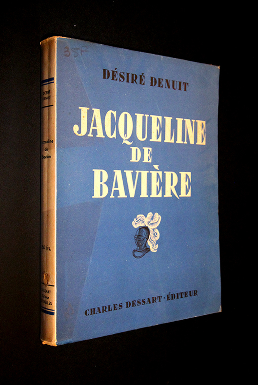
Denuit Désiré
Jacqueline de Bavière : princesse infortunée
Dessart Charles Broché In-8 (15,3x 21,5 cm), broché, sans date, 226 pages, reproduction du portrait présumé de Jacqueline de Bavière en noir et blanc hors-texte en regard de la page du titre ; pliures et incident au dos en queue, coiffe inférieure frottée, quelques rousseurs au premier plat et aux gardes, ouvrage uniformément jauni, par ailleurs assez bon état général. Livraison a domicile (La Poste) ou en Mondial Relay sur simple demande.
Bookseller reference : lu1916
|
|
|
Denys J. Holland
Weather Inference for Beginners: Made Clear in a Series of Actual Examples
2013-08-01. New. Ships with Tracking Number! INTERNATIONAL WORLDWIDE Shipping available. May be re-issue. Buy with confidence excellent customer service! unknown
Bookseller reference : 1107619491n ISBN : 1107619491 9781107619494

|
|
|
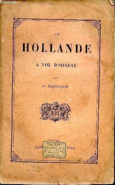
Depelchin (P.).
LA HOLLANDE A VOL D'OISEAU.
Tours, Mame, 1880. In-8 rel. pl. toile, front., 213p., grav. in-txt. 2ème charnière lég. fendue, très lég. rousseurs.
Bookseller reference : 842
|
|
|
DEPELCHIN P
La Hollande a vol d'oiseau.
Tours, Mame et fils 1884. 4.ième édition. 8°. 213 S. 1 Bl. mit zahlreichen, ganzseitigen Holzstichillustrationen, OLeinen mit Rü. Vergoldung u. Goldauzfschrift a. Rü., Einbd leicht berieben, einige SS. ganz leicht fleckig, im Ganzen gut erhalten. 4
Bookseller reference : 30661AB
|
|
|
DEPELCHIN P.
La Hollande à vol d'oiseau
Mame et Fils. 1884. In-8. Broché. Etat d'usage, Tâchée, Coiffe en tête abîmée, Fortes mouillures. 213 pp. Coiffe de pied abîmée. Gravures hors-texte à l'italienne.. . . . Classification Dewey : 949.2-Pays Bas
Bookseller reference : ROD0011237
|
|
|
DEPELCHIN P.
La Hollande à vol d'oiseau.
Couverture souple. Broché. 213 pages. Rousseurs.
Bookseller reference : 6645
|
|
|
DEPELCHIN P.
La Hollande à vol d'oiseau.
Couverture rigide. Reliure pleine toile rouge de l'éditeur. 14 x 22 cm. 215 pages. Quelques rousseurs.
Bookseller reference : 85997

|
|
|
Derek Holland/ Nick Griffin/ Udo Voigt
Zeiten des Wandels: Beitr�ge zur Reconquista
Europa Terra Nostra e.V. 2017. Paperback. New. 126 pages. German language. 8.50x5.51x0.30 inches. Europa Terra Nostra e.V. paperback
Bookseller reference : __3981806514 ISBN : 3981806514 9783981806519
|
|
|
Derek Holland
Creatures of the Wastelands: A Menagerie of Mutants and Mutations
2015-04-25. New. Ships with Tracking Number! INTERNATIONAL WORLDWIDE Shipping available. May be re-issue. Buy with confidence excellent customer service! unknown
Bookseller reference : 1935050338n ISBN : 1935050338 9781935050339

|
|
|
Derek Holland
Creatures of the Wastelands: Mutational Evolution
2015-04-24. New. Ships with Tracking Number! INTERNATIONAL WORLDWIDE Shipping available. May be re-issue. Buy with confidence excellent customer service! unknown
Bookseller reference : 1935050354n ISBN : 1935050354 9781935050353

|
|
|
Derek Holland
Creatures of the Wastelands: Mutational Evolution
2015-04-24. Good. Ships with Tracking Number! INTERNATIONAL WORLDWIDE Shipping available. May not contain Access Codes or Supplements. May be re-issue. May be ex-library. Shipping & Handling by region. Buy with confidence excellent customer service! unknown
Bookseller reference : 1935050354 ISBN : 1935050354 9781935050353

|
|
|
Derek. Holland
Changing landscapes in South Yorkshire
Shaw. 91 pages. Large size 30cm x 21cm. 'Typed' style pages in soft card covers and loose 'poster' type spine binding. The edges of the cover have become slightly creased/torn where they overlap the original main body of the booklet. Signs of general wear esp. to cover but sound booklet in soft card card covers. Changing landscapes in South Yorkshire . Good. Soft cover. 1980. Shaw paperback
Bookseller reference : 086866 ISBN : 0950689807 9780950689807
|
|
|
Derksen, Johan u.v.a
Het Nederlands Elftal - de Historie van Oranje - 1905-1989
Uitgeverij Luitingh-Sijthoff, 1989. Halbleinen, mit farbiger Deckelillustration, ca.DinA 4, fast quadratisch, 439 Seiten, viele sw-Photos und Farbfotos und statistische Angaben, Einband mit geringen Gebrauchsspuren, Rücken leicht fleckig, Vorderdeckel minimal eckbestoßen, Seiten minimal randgebräunt, (sehr) gut erhalten / (sehr) guter Zustand [2 Warenabbildungen]
Bookseller reference : 250759sp

|
|
|
DEROY Auguste-Victor (peintre, aquarelliste et lithographe)
NANTES ET SES ENVIRONS : "LA FOSSE VUE DE LA PETITE HOLLANDE (A NANTES)"
Nantes SEBIRE 1833 Une lithographie Originale en noir (avant la lettre) sur papier de chine contrecollé d'après les dessins de Deroy, Format total de la gravure : Hauteur : 25 centimètres Largeur : 32 centimètres, format de la gravure seule : 13,5 cm de haut par 20 cm de large, gravure sur papier blanc, noté en bas à gauche à la mine de plomb : "à gauche les Bains" + noté en bas à droite sous la cuvette : "LA FOSSE VUE DE LA PETITE HOLLANDE (A NANTES)", gravure extraite de "Nantes et ses Environs" par Deroy, 1833 Nantes SEBIRE Editeur,
Bookseller reference : 24946
|
|
|
Des Barres JFW. publisher: Holland Samuel and George Callendar surveyors J. F.
A CHART OF THE HARBOUR OF BOSTON COMPOSED FROM DIFFERENT SURVEYS; BUT PRINCIPALLY FROM THAT TAKEN IN 1769 BY MR. GEORGE CALLENDAR LATE MASTER OF HIS MAJESTY'S SHIP THE ROMNEY
London: Published by J.F.W. Des Barres in THE ATLANTIC NEPTUNE 1775. Copper-engraved and etched map with aquatint on two joined sheets. Printed on laid paper with "J Bates" watermark and "JB" countermark. Sheet size: 30 1/4 x 42 5/8 inches. In excellent condition. Accompanied by the folio explanatory text leaf titled as above. 1p. The finest and most celebrated sea chart of Boston Harbor ever produced and a highly important Revolutionary War map depicting details relating to the Siege of Boston: with the very rare explanatory text leaf. This is one the most important maps contained in Des Barres' THE ATLANTIC NEPTUNE and one of the most significant large-scale maps of the Revolutionary War. It provides an invaluable record of Boston at the beginning of the war covering the area from the environs of the city out into the open waters of Massachusetts Bay. A particularly striking feature is the use of boldly etched and subtly aquatinted details to capture the diverse topography of the region including the numerous hills islands and river estuaries. It is important to remember that this was issued as a working sea chart and as such the cartographer has naturally concentrated on features such as depth soundings indicated by detailed lines and based on surveys by Samuel Holland and George Callendar and the navigable channels between the harbor's numerous shoals which are delicately outlined in stipple-engraving. Holland's original manuscript map is today preserved in the British Hydrographic Library at Taunton Somerset. The present map shows the city of Boston with its streets carefully outlined occupying a pear-shaped peninsula a position that would soon prove precarious to its British defenders in the escalating conflict. This is the second state of five of Des Barres' chart and is identical to the HENRY STEVENS COLLECTION variant 96D in the National Maritime Museum Greenwich. This state shows a number of notable changes when compared with the original and was evidently altered to take particular account of the Siege of Boston April 19 1775 to March 17 1776. Henry Stevens noted that this state depicted the addition of "Numerous Forts Batteries Redoubts &c. which have been inserted in many places notably on the Charles Town peninsula and on the mainland between 'Willis Creek' and 'Mystic River' also on the east and north side of 'Charles River' below 'Cambridge'.also to the south of 'Boston Neck' and 'Dorchester Neck'.This state is almost as rare as the first state. It is found in some copies of the earliest edition of the Neptune." The accuracy scope and artistic virtue of Des Barres's CHART OF THE HARBOUR OF BOSTON was apparent to his contemporaries and it became the main source map of the area for decades to come. Joseph Frederick Wallet Des Barres was born in Switzerland where his Huguenot ancestors had fled following the repeal of the Edict of Nantes. He studied under the great mathematician Daniel Bernoulli at the University of Basel before immigrating to Britain where he trained at the Royal Military College Woolwich. Upon the outbreak of hostilities with France in 1756 he joined the British Royal American Regiment as a military engineer. He came to the attention of Gen. James Wolfe who appointed him to join his personal detail. During this period he also worked with the legendary future explorer James Cook on a monumental chart of the St. Lawrence River. Upon the conclusion of the Seven Years' War Britain's empire in North America was greatly expanded and this required the creation of a master atlas featuring new and accurate sea charts for use by the Royal Navy. Des Barres was enlisted to survey the coastlines of Nova Scotia Newfoundland and the Gulf of St. Lawrence. With these extremely accurate surveys in hand Des Barres returned to London in 1774 where the Royal Navy charged him with the Herculean task of producing the atlas. He was gradually forwarded the manuscripts of numerous advanced surveys conducted by British cartographers in the American Colonies Jamaica and Cuba of which the present map is based on the work of Samuel Holland conducted in the 1760s. The result was THE ATLANTIC NEPTUNE which became the most celebrated sea atlas of its era containing the first systematic survey of the east coast of North America. Des Barres' synergy of great empirical accuracy with the peerless artistic virtue of his aquatint views created a work that "has been described as the most splendid collection of charts plates and views ever published" NMM. THE ATLANTIC NEPTUNE eventually consisted of four volumes and Des Barres' dedication to the project was so strong that often at his own expense he continually updated and added new charts and views to various editions up until 1784 producing over 250 charts and views many appearing in several variations. All of these charts were immensely detailed featuring both hydrographical and topographical information such that in many cases they remained the most authoritative maps of the regions covered for several decades. Following the completion of THE ATLANTIC NEPTUNE Des Barres returned to Canada where he remained for a further forty years becoming a senior political figure and a wealthy land owner living to the advanced age of 103. GUTHORN referring to Holland's original mansucripts 59/3. A. Krieger & D. Cobb MAPPING BOSTON p.107 1781 issue. R. Lingel "The Atlantic Neptune" in BULLETIN OF THE NEW YORK PUBLIC LIBRARY Vol. 40 No. 7 July 1936 N91.2. NEBENZAHL 3. NMM HENRY STEVENS COLLECTION K0713 HNS 96D. Stevens "Bibliography of the Atlantic Neptune" unpublished pp.211-16. SELLERS & VAN EE 945. Published by J.F.W. Des Barres in THE ATLANTIC NEPTUNE unknown
Bookseller reference : WRCAM37280

|
|
|
DES BARRES J. F. W. 1721 1824 publisher Samuel HOLLAND 1728 1801 and George CALLENDAR fl. around 1769 surveyors
A Chart of the Harbour of Boston Composed from different Surveys; but principally from that taken in 1769 by Mr. George Callendar Late Master of His Majesty's Ship the Romney
London: Published by J.F.W. Des Barres in 'The Atlantic Neptune' 1775. Copper-engraved and etched map with aquatint on two joined sheets. Printed on laid paper with `J Bates' watermark and `JB' countermark in excellent condition. Sheet size: 30 1/4 x 42 5/8 inches. With: The explanatory text leaf titled as above. 1p. folio 25 1/2 x 19 inches. The finest and most celebrated sea chart of Boston Harbor ever produced and a highly important Revolutionary War map depicting details relating to the Siege of Boston: with the very rare explanatory text leaf. This is one the most important maps contained in Des Barres' The Atlantic Neptune and one of the most significant large-scale maps of the Revolutionary War. It provides an invaluable record of Boston at the beginning of the war covering the area from the environs of the city out into the open waters of Massachusetts Bay. A particularly striking feature is the use of boldly etched and subtly aquatinted details to capture the diverse topography of the region including the numerous hills islands and river estuaries. It is important to remember that this was issued as a working sea-chart and as such the cartographer has naturally concentrated on features such as depth soundings indicated by detailed lines and based on surveys by Samuel Holland and George Callendar and the navigable channels between the harbor's numerous shoals which are delicately outlined in stipple-engraving. Holland's original manuscript map is today preserved in the British Hydrographic Library at Taunton Somerset. The present map shows the city of Boston with its streets carefully outlined occupying a pear-shaped peninsula a position that would soon prove precarious to its British defenders in the escalating conflict. This is the second state of five of Des Barres' chart and is identical to the Henry Stevens Collection variant 96D in the National Maritime Museum Greenwich. This state shows a number of notable changes when compared with the original and was evidently altered to take particular account of the Siege of Boston April 19 1775 to March 17 1776. Henry Stevens noted that this state depicted the addition of "Numerous Forts Batteries Redoubts &c. which have been inserted in many places notably on the Charles Town peninsula and on the mainland between 'Willis Creek' and 'Mystic River' also on the east and north side of 'Charles River' below 'Cambridge'.also to the south of 'Boston Neck' and 'Dorchester Neck'.This state is almost as rare as the first state. It is found in some copies of the earliest edition of the Neptune." The accuracy scope and artistic virtue of Des Barres's Chart of the Harbour of Boston was apparent to his contemporaries and it became the main source map of the area for decades to come. Joseph Frederick Wallet Des Barres was born in Switzerland where his Huguenot ancestors had fled following the repeal of the Edict of Nantes. He studied under the great mathematician Daniel Bernoulli at the University of Basel before immigrating to Britain where he trained at the Royal Military College Woolwich. Upon the outbreak of hostilities with France in 1756 he joined the British Royal American Regiment as a military engineer. He came to the attention of General James Wolfe who appointed him to join his personal detail. During this period he also worked with the legendary future explorer James Cook on a monumental chart of the St. Lawrence River. Upon the conclusion of the Seven Years War Britain's empire in North America was greatly expanded and this required the creation of a master atlas featuring new and accurate sea charts for use by the Royal Navy. Des Barres was enlisted to survey the coastlines of Nova Scotia Newfoundland and the Gulf of St. Lawrence. With these extremely accurate surveys in hand Des Barres returned to London in 1774 where the Royal Navy charged him with the Herculean task of producing the atlas. He was gradually forwarded the manuscripts of numerous advanced surveys conducted by British cartographers in the American Colonies Jamaica and Cuba of which the present map is based on the work of Samuel Holland conducted in the 1760s. The result was The Atlantic Neptune which became the most celebrated sea atlas of its era containing the first systematic survey of the east coast of North America. Des Barres's synergy of great empirical accuracy with the peerless artistic virtue of his aquatint views created a work that "has been described as the most splendid collection of charts plates and views ever published" National Maritime Museum Catalogue. The Neptune eventually consisted of four volumes and Des Barres's dedication to the project was so strong that often at his own expense he continually updated and added new charts and views to various editions up until 1784 producing over 250 charts and views many appearing in several variations. All of these charts were immensely detailed featuring both hydrographical and topographical information such that in many cases they remained the most authoritative maps of the regions covered for several decades. Following the completion of The Neptune Des Barres returned to Canada where he remained for a further forty years becoming a senior political figure and a wealthy land owner living to the advanced age of 103. Cf. GuthornBritish Maps of the American Revolution referring to Holland's original manuscript 59/3; Krieger & Cobb p.107 1781 issue; Lingel Atlantic Neptune N91.2; National Maritime Museum Henry Stevens Collection K0713 HNS 96D; National Maritime Museum Catalogue 78-83; Nebenzahl Bibliography 3; Stevens Bibliography of the Atlantic Neptune unpublished pp.211-216; Sellers & Van Ee 945. Published by J.F.W. Des Barres in 'The Atlantic Neptune' unknown
Bookseller reference : 17671

|
|
|
DES BARRES J. F. W. 1721 1824 publisher Samuel HOLLAND 1728 1801 and John KNIGHT
A plan of Fort Montgomery and Fort Clinton taken by His Majesty's forces under the command of Maj. Gen.l Sir Henry Clinton K.B: Survey'd by Major Holland Surv.r Gen.l &c. . With large inset titled: Part of Hudsons River shewing the position of Fort Montgomery and Fort Clinton with the Chevaux de Frieze cables chains &c to obstruct the passage of his Majesty's forces up the river. By Lieut. John Knight of the Royal Navy in 1777
London 1779. Engraved and aquatint map period hand colouring. 14 lettered references large inset with title as above. Rare revolutionary chart of the Hudson River showing the American defenses on the eve of the Battle of Fort Montgomery. On October 6 1777 a British force led by Lieutenant General Sir Henry Clinton attacked Forts Montgomery and Clinton from the landward side where the American defenses were only partially completed. Support from cannon fire from British ships on the Hudson River that had passed through the chevaux de frise on the lower river. By the end of the day both forts had fallen to the British who burned the forts and tore down the stonework buildings. However the battle was a pyrrhic victory for the British. The campaign against the forts caused delays in reinforcing General John Burgoyne at Saratoga where Americans forced the British surrender ten days later at the Battle of Saratoga before Clinton's forces could arrive. The present map which depicts the Forts and the River defenses prior to the battle is from The Atlantic Neptune the finest large scale sea atlas of the United States and Canadian Atlantic coastline ever produced. The maps in the atlas were produced over a seven-year period 1775-82 and are well known for their accurate portrayal of various sounds bays bars harbors as well as navigational hazards. This atlas was used extensively by the Royal Navy during the American Revolution. Des Barres studied under the great mathematician Daniel Bernoulli at the University of Basel before continuing on to the Royal Military College at Woolwich. On the outbreak of the Seven Years war in 1756 he joined the British Royal American Regiment as a military engineer. He came to the attention of General James Wolfe who appointed him to be his aide-de-camp. From 1762 Des Barres was enlisted to survey the coastlines of Nova Scotia Newfoundland and the Gulf of St.Lawrence while his colleague Samuel Holland charted the New England coast and further south. In 1774 Des Barres returned to England where he began work on the Neptune. His dedication to the project was so strong that often at his own expense he continually updated and added new charts and views up until 1784. That year he returned to Canada where he remained for a further forty years becoming a senior political figure and a wealthy land owner and living to the advanced age of 103. The Atlantic Neptune was the first British sea atlas of her North American colonies and one of the most important achievements of eighteenth century cartography. With an official commission from the Royal Navy Des Barres published the first volume in London in 1775 which was soon followed by further volumes. Des Barres' monumental endeavor eventually featured over two-hundred charts and aquatint views many being found in several states. All of the charts were immensely detailed featuring both hydrographical and topographical information. The Neptune met with the highest acclaim from the beginning and is today widely regarded as superior to all other atlases produced during its time. Henry Stevens identified only a single state of this chart issued coloured or uncoloured which appeared in some examples volume four part two of the Atlantic Nepture; the map however is not listed in the engraved list of maps for that section and given the rarity was likely not issued in all copies. National Maritime Museum: Henry Stevens Collection: HNS156; Cf. Phillips Atlases 1198; Hornsby Surveyors of Empire: Samuel Holland J.F.W. Des Barres and the Making of the Atlantic Neptune 2011. unknown
Bookseller reference : 33200

|
|
|
DES BARRES JOSEPH FREDERICK WALLET 1721 1824 and SAMUEL HOLLAND
Buzzards Bay and Vineyard Sound.
London: J. F. W. Des Barres for The Atlantic Neptune 1776. Large engraved chart from Des Barres' Atlantic Neptune on two sheets of laid paper joined each bearing "J Bates" watermark. 43x31 inches sheet size nice margins; contemporary hand-color in outline; slightest offsetting a superior copy. State 4 of 7. Fine chart depicting the waters between New Bedford and Martha's Vineyard. Buzzards Bay and the Vineyard Sound including the Elizabeth Islands and the western half of Martha's Vineyard. Showing much more on-shore information than is typical for a Des Barres chart there are details of property boundaries structures even a road from Menemshaw Pond to Tisbury. Native names throughout remain largely unchanged today. Joseph Des Barres was born in Switzerland in 1721 and educated in Basel before emigrating to England and entering the Royal Military College where he learned engineering and the art of surveying. In 1756 Des Barres was commissioned a Lieutenant in the Royal American Regiment and dispatched to North America. He served in America during the Seven Years War under Colonel Bouquet Lord Howe and General Amherst and participated in the Quebec campaign as General Wolfe's engineer. Though Des Barres was responsible for the surveys done of Nova Scotia and the Isle of Sable the surveying of the coastline of what became the United States was undertaken by Major Samuel Holland a Dutchman who joined the British army during the French and Indian War as an engineer and became ultimately Surveyor General for North America. Holland was in charge of a rather large staff that included Charles Blaskowitz and George Gauld. They ultimately provided greatly improved charts for the entire coastline and the Gulf of Mexico. All this work was done prior to the Revolution which necessarily brought the surveys to an end. The publishing supervised by Des Barres continued throughout the war years. Des Barres compiled and edited the atlas maintaining a high standard throughout. His primary motive seems to have been the navigational usefulness of the charts. He clearly envisioned a navigator's needs in approaching a shoreline. The Atlantic Neptune was the first new survey of American coastlines in a century and the need was very great. The charts were plagiarized for the next thirty or forty years. Des Barres also had a flare for making charts aesthetically appealing so that they are invariably handsome as well as unfailingly interesting. Stevens 88D; John Carter Brown Library Charting the East Coast of North America The Atlantic Neptune Providence: 1972; Robert Lingel 'The Atlantic Neptune' in the Bulletin of the New York Public Library July 1936 pp.571-603; Augustus P. Loring 'The Atlantic Neptune' in American Maritime Prints New Bedford: 1985. J. F. W. Des Barres for The Atlantic Neptune unknown
Bookseller reference : 33412

|
|
|
Des Barres Joseph Frederick Wallet and Samuel Holland
BUZZARDS BAY AND VINEYARD SOUND
London: J.F.W. Des Barres for THE ATLANTIC NEPTUNE 1776. Large engraved chart from Des Barres' ATLANTIC NEPTUNE on two sheets of laid paper joined each bearing "J Bates" watermark. Sheet size: 43 x 31 inches. Contemporary hand- coloring in outline. Slightest offsetting. A superior copy. A highly important chart depicting Buzzards Bay and the Vineyard Sound including the Elizabeth Islands and the western half of Martha's Vineyard compiled under the direction of Joseph Des Barres. Showing much more on- shore information than is typical for a Des Barres chart there are details of property boundaries structures even a road from Menemshaw Pond to Tisbury. Native names throughout remain largely unchanged today. This is one of the most interesting charts from the vast ATLANTIC NEPTUNE project. THE ATLANTIC NEPTUNE was the first new survey of American coastlines in a century and the need was very great. Joseph Des Barres was born in Switzerland in 1721 and educated in Basel before emigrating to England and entering the Royal Military College where he learned engineering and the art of surveying. In 1756 Des Barres was commissioned a lieutenant in the Royal American Regiment and dispatched to North America. He served in America during the Seven Years' War under Col. Bouquet Lord Howe and Gen. Amherst and participated in the Quebec campaign as Gen. Wolfe's engineer. In the late 1760's the project of surveying the entirely Atlantic coastline of North america began working from north to south under Des Barres' direction. Although Des Barres was directly responsible for the surveys done of Nova Scotia and the Isle of Sable the surveying of much of the coastline of what became the United States was undertaken by Major Samuel Holland a Dutchman who joined the British army during the French and Indian War as an engineer and became ultimately Surveyor General for North America. Holland was in charge of a rather large staff that included Charles Blaskowitz and George Gauld. They ultimately provided greatly improved charts for the entire coastline and the Gulf of Mexico. All this work was done prior to the Revolution which brought the surveys to an end. The publishing supervised by Des Barres continued throughout the war years. Des Barres compiled and edited the atlas maintaining a high standard throughout. His primary motive seems to have been the navigational usefulness of the charts. He clearly envisioned a navigator's needs in approaching a shoreline. The charts were plagiarized for the next thirty or forty years. Des Barres also had a flare for making charts aesthetically appealing so that they are invariably handsome as well as unfailingly interesting. This is the fourth state of seven recorded by Stevens. STEVENS 88D. John Carter Brown Library CHARTING THE EAST COAST OF NORTH AMERICA The Atlantic Neptune Providence 1972. Robert Lingel "THE ATLANTIC NEPTUNE" in BULLETIN OF THE NEW YORK PUBLIC LIBRARY July 1936 pp.571-603. Augustus P. Loring "THE ATLANTIC NEPTUNE" in AMERICAN MARITIME PRINTS New Bedford 1985. J.F.W. Des Barres for THE ATLANTIC NEPTUNE unknown
Bookseller reference : WRCAM53005

|
|
|
DES BARRES J. F. W. publisher and SAMUEL HOLLAND
Untitled chart of Boston Bay
London: J. F. W. Des Barres 1776. Engraved with color wash and outline color. Sheet: 31 x 42 1/4 inches. Expert restoration primarily at the upper margin. Two sheets joined both watermarked "J.Bates" and countermarked "JB". Fourth state of five. Among the earliest charts published by Des Barres were those relevant to the crisis in New England as the War of Independence broke out. This chart depicts the coast of Massachusetts from Salem to Scituate Harbor and includes the complicated hydrography of Boston Harbor and the confluent rivers. A considerable amount of coastal topography is included obviously relevant to warships. Fundamentally a chart for navigators it includes soundings and shoals with particularly strong detail along the Charles and Mystic Rivers as well as in Salem and Marblehead. Samuel Holland was the lead surveyor. In 1764 he was named Surveyor General of both the Province of Quebec and the Northern District of North America. He had a considerable staff and the British Navy assisted in providing soundings. From 1770 to 1774 his squad worked exclusively on northeastern colonies that soon became part of the United States. The surveys that derived from the industry of their work were the most accurate ever made to that time. They were sent to London where Des Barres supervised the engraving and publication. The charts were very soon put to use. Des Barres of Swiss-Huguenot extraction studied under the great mathematician Daniel Bernoulli at the University of Basel before continuing on to the Royal Military College at Woolwich. Upon the outbreak of hostilities with France in 1756 he joined the British Royal American Regiment as a military engineer. He came to the attention of General James Wolfe who appointed him to join his personal detail. During this period he also worked with the future legendary explorer James Cook on a monumental chart of the St. Lawrence River. From 1762 Des Barres was enlisted to survey the coastlines of Nova Scotia Newfoundland and the Gulf of St. Lawrence while his colleague Samuel Holland charted the New England coast. He also managed to gain access to some surveys of the American South Cuba and Jamaica. In 1774 Des Barres returned to England where he began work on The Neptune. His dedication to the project was so strong that often at his own expense he continually updated and added new charts and views up until 1784. That year he returned to Canada where he remained for a further forty years becoming a senior political figure and a wealthy land owner and living to the advanced age of 103. Stevens Collection 94d ; cf. Hornsby Surveyors of Empire: Samuel Holland J.F.W. Des Barres and the Making of the Atlantic Neptune. 2011. J. F. W. Des Barres unknown
Bookseller reference : 34405

|
|
|
DES BARRES J. F. W. 1721 1824 publisher Samuel HOLLAND 1728 1801 and George CALLENDAR fl. around 1769 surveyors
A Chart of the Harbour of Boston Composed from different Surveys; but principally from that taken in 1769 by Mr. George Callendar Late Master of His Majesty's Ship the Romney
London: Published by J.F.W. Des Barres in 'The Atlantic Neptune' 1775. Copper-engraved and etched map with aquatint on two joined sheets. Printed on laid paper with `J Bates' watermark and `JB' countermark in excellent condition. Sheet size: 30 1/4 x 42 5/8 inches. With: The explanatory text leaf titled as above. 1p. folio 25 1/2 x 19 inches. The finest and most celebrated sea chart of Boston Harbor ever produced and a highly important Revolutionary War map depicting details relating to the Siege of Boston: with the very rare explanatory text leaf.<br/> <br/>This is one the most important maps contained in Des Barres' The Atlantic Neptune and one of the most significant large-scale maps of the Revolutionary War. It provides an invaluable record of Boston at the beginning of the war covering the area from the environs of the city out into the open waters of Massachusetts Bay. A particularly striking feature is the use of boldly etched and subtly aquatinted details to capture the diverse topography of the region including the numerous hills islands and river estuaries. It is important to remember that this was issued as a working sea-chart and as such the cartographer has naturally concentrated on features such as depth soundings indicated by detailed lines and based on surveys by Samuel Holland and George Callendar and the navigable channels between the harbor's numerous shoals which are delicately outlined in stipple-engraving. Holland's original manuscript map is today preserved in the British Hydrographic Library at Taunton Somerset. The present map shows the city of Boston with its streets carefully outlined occupying a pear-shaped peninsula a position that would soon prove precarious to its British defenders in the escalating conflict. This is the second state of five of Des Barres' chart and is identical to the Henry Stevens Collection variant 96D in the National Maritime Museum Greenwich. This state shows a number of notable changes when compared with the original and was evidently altered to take particular account of the Siege of Boston April 19 1775 to March 17 1776. Henry Stevens noted that this state depicted the addition of "Numerous Forts Batteries Redoubts &c. which have been inserted in many places notably on the Charles Town peninsula and on the mainland between 'Willis Creek' and 'Mystic River' also on the east and north side of 'Charles River' below 'Cambridge'.also to the south of 'Boston Neck' and 'Dorchester Neck'.This state is almost as rare as the first state. It is found in some copies of the earliest edition of the Neptune." The accuracy scope and artistic virtue of Des Barres's Chart of the Harbour of Boston was apparent to his contemporaries and it became the main source map of the area for decades to come. Joseph Frederick Wallet Des Barres was born in Switzerland where his Huguenot ancestors had fled following the repeal of the Edict of Nantes. He studied under the great mathematician Daniel Bernoulli at the University of Basel before immigrating to Britain where he trained at the Royal Military College Woolwich. Upon the outbreak of hostilities with France in 1756 he joined the British Royal American Regiment as a military engineer. He came to the attention of General James Wolfe who appointed him to join his personal detail. During this period he also worked with the legendary future explorer James Cook on a monumental chart of the St. Lawrence River. Upon the conclusion of the Seven Years War Britain's empire in North America was greatly expanded and this required the creation of a master atlas featuring new and accurate sea charts for use by the Royal Navy. Des Barres was enlisted to survey the coastlines of Nova Scotia Newfoundland and the Gulf of St. Lawrence. With these extremely accurate surveys in hand Des Barres returned to London in 1774 where the Royal Navy charged him with the Herculean task of producing the atlas. He was gradually forwarded the manuscripts of numerous advanced surveys conducted by British cartographers in the American Colonies Jamaica and Cuba of which the present map is based on the work of Samuel Holland conducted in the 1760s. The result was The Atlantic Neptune which became the most celebrated sea atlas of its era containing the first systematic survey of the east coast of North America. Des Barres's synergy of great empirical accuracy with the peerless artistic virtue of his aquatint views created a work that "has been described as the most splendid collection of charts plates and views ever published" National Maritime Museum Catalogue. The Neptune eventually consisted of four volumes and Des Barres's dedication to the project was so strong that often at his own expense he continually updated and added new charts and views to various editions up until 1784 producing over 250 charts and views many appearing in several variations. All of these charts were immensely detailed featuring both hydrographical and topographical information such that in many cases they remained the most authoritative maps of the regions covered for several decades. Following the completion of The Neptune Des Barres returned to Canada where he remained for a further forty years becoming a senior political figure and a wealthy land owner living to the advanced age of 103.<br/> <br/>Cf. GuthornBritish Maps of the American Revolution referring to Holland's original manuscript 59/3; Krieger & Cobb p.107 1781 issue; Lingel Atlantic Neptune N91.2; National Maritime Museum Henry Stevens Collection K0713 HNS 96D; National Maritime Museum Catalogue 78-83; Nebenzahl Bibliography 3; Stevens Bibliography of the Atlantic Neptune unpublished pp.211-216; Sellers & Van Ee 945. Published by J.F.W. Des Barres in 'The Atlantic Neptune' unknown books
Bookseller reference : 17671
|
|
|
DES BARRES J. F. W. 1721 1824 publisher Samuel HOLLAND 1728 1801 and John KNIGHT
A plan of Fort Montgomery and Fort Clinton taken by His Majesty's forces under the command of Maj. Gen.l Sir Henry Clinton K.B: Survey'd by Major Holland Surv.r Gen.l &c. . With large inset titled: Part of Hudsons River shewing the position of Fort Montgomery and Fort Clinton with the Chevaux de Frieze cables chains &c to obstruct the passage of his Majesty's forces up the river. By Lieut. John Knight of the Royal Navy in 1777
London 1779. Engraved and aquatint map period hand colouring. 14 lettered references large inset with title as above. Rare revolutionary chart of the Hudson River showing the American defenses on the eve of the Battle of Fort Montgomery.<br/> <br/>On October 6 1777 a British force led by Lieutenant General Sir Henry Clinton attacked Forts Montgomery and Clinton from the landward side where the American defenses were only partially completed. Support from cannon fire from British ships on the Hudson River that had passed through the chevaux de frise on the lower river. By the end of the day both forts had fallen to the British who burned the forts and tore down the stonework buildings. However the battle was a pyrrhic victory for the British. The campaign against the forts caused delays in reinforcing General John Burgoyne at Saratoga where Americans forced the British surrender ten days later at the Battle of Saratoga before Clinton's forces could arrive. The present map which depicts the Forts and the River defenses prior to the battle is from The Atlantic Neptune the finest large scale sea atlas of the United States and Canadian Atlantic coastline ever produced. The maps in the atlas were produced over a seven-year period 1775-82 and are well known for their accurate portrayal of various sounds bays bars harbors as well as navigational hazards. This atlas was used extensively by the Royal Navy during the American Revolution. Des Barres studied under the great mathematician Daniel Bernoulli at the University of Basel before continuing on to the Royal Military College at Woolwich. On the outbreak of the Seven Years war in 1756 he joined the British Royal American Regiment as a military engineer. He came to the attention of General James Wolfe who appointed him to be his aide-de-camp. From 1762 Des Barres was enlisted to survey the coastlines of Nova Scotia Newfoundland and the Gulf of St.Lawrence while his colleague Samuel Holland charted the New England coast and further south. In 1774 Des Barres returned to England where he began work on the Neptune. His dedication to the project was so strong that often at his own expense he continually updated and added new charts and views up until 1784. That year he returned to Canada where he remained for a further forty years becoming a senior political figure and a wealthy land owner and living to the advanced age of 103. The Atlantic Neptune was the first British sea atlas of her North American colonies and one of the most important achievements of eighteenth century cartography. With an official commission from the Royal Navy Des Barres published the first volume in London in 1775 which was soon followed by further volumes. Des Barres' monumental endeavor eventually featured over two-hundred charts and aquatint views many being found in several states. All of the charts were immensely detailed featuring both hydrographical and topographical information. The Neptune met with the highest acclaim from the beginning and is today widely regarded as superior to all other atlases produced during its time. Henry Stevens identified only a single state of this chart issued coloured or uncoloured which appeared in some examples volume four part two of the Atlantic Nepture; the map however is not listed in the engraved list of maps for that section and given the rarity was likely not issued in all copies.<br/> <br/>National Maritime Museum: Henry Stevens Collection: HNS156; Cf. Phillips Atlases 1198; Hornsby Surveyors of Empire: Samuel Holland J.F.W. Des Barres and the Making of the Atlantic Neptune 2011. unknown books
Bookseller reference : 33200
|
|
|
DES BARRES J. F. W. publisher and SAMUEL HOLLAND
Untitled chart of Boston Bay
London: J. F. W. Des Barres 1776. Engraved with color wash and outline color. Sheet: 31 x 42 1/4 inches. Expert restoration primarily at the upper margin. Two sheets joined both watermarked "J.Bates" and countermarked "JB". Fourth state of five. Among the earliest charts published by Des Barres were those relevant to the crisis in New England as the War of Independence broke out.<br/> <br/>This chart depicts the coast of Massachusetts from Salem to Scituate Harbor and includes the complicated hydrography of Boston Harbor and the confluent rivers. A considerable amount of coastal topography is included obviously relevant to warships. Fundamentally a chart for navigators it includes soundings and shoals with particularly strong detail along the Charles and Mystic Rivers as well as in Salem and Marblehead. Samuel Holland was the lead surveyor. In 1764 he was named Surveyor General of both the Province of Quebec and the Northern District of North America. He had a considerable staff and the British Navy assisted in providing soundings. From 1770 to 1774 his squad worked exclusively on northeastern colonies that soon became part of the United States. The surveys that derived from the industry of their work were the most accurate ever made to that time. They were sent to London where Des Barres supervised the engraving and publication. The charts were very soon put to use. Des Barres of Swiss-Huguenot extraction studied under the great mathematician Daniel Bernoulli at the University of Basel before continuing on to the Royal Military College at Woolwich. Upon the outbreak of hostilities with France in 1756 he joined the British Royal American Regiment as a military engineer. He came to the attention of General James Wolfe who appointed him to join his personal detail. During this period he also worked with the future legendary explorer James Cook on a monumental chart of the St. Lawrence River. From 1762 Des Barres was enlisted to survey the coastlines of Nova Scotia Newfoundland and the Gulf of St. Lawrence while his colleague Samuel Holland charted the New England coast. He also managed to gain access to some surveys of the American South Cuba and Jamaica. In 1774 Des Barres returned to England where he began work on The Neptune. His dedication to the project was so strong that often at his own expense he continually updated and added new charts and views up until 1784. That year he returned to Canada where he remained for a further forty years becoming a senior political figure and a wealthy land owner and living to the advanced age of 103.<br/> <br/>Stevens Collection 94d ; cf. Hornsby Surveyors of Empire: Samuel Holland J.F.W. Des Barres and the Making of the Atlantic Neptune. 2011. J. F. W. Des Barres unknown books
Bookseller reference : 34405
|
|
|
DES BARRES JOSEPH FREDERICK WALLET 1721 1824 and SAMUEL HOLLAND
Buzzards Bay and Vineyard Sound.
London: J. F. W. Des Barres for The Atlantic Neptune 1776. Large engraved chart from Des Barres' Atlantic Neptune on two sheets of laid paper joined each bearing "J Bates" watermark. 43x31 inches sheet size nice margins; contemporary hand-color in outline; slightest offsetting a superior copy. State 4 of 7. Fine chart depicting the waters between New Bedford and Martha's Vineyard.<br/> <br/>Buzzards Bay and the Vineyard Sound including the Elizabeth Islands and the western half of Martha's Vineyard. Showing much more on-shore information than is typical for a Des Barres chart there are details of property boundaries structures even a road from Menemshaw Pond to Tisbury. Native names throughout remain largely unchanged today. Joseph Des Barres was born in Switzerland in 1721 and educated in Basel before emigrating to England and entering the Royal Military College where he learned engineering and the art of surveying. In 1756 Des Barres was commissioned a Lieutenant in the Royal American Regiment and dispatched to North America. He served in America during the Seven Years War under Colonel Bouquet Lord Howe and General Amherst and participated in the Quebec campaign as General Wolfe's engineer. Though Des Barres was responsible for the surveys done of Nova Scotia and the Isle of Sable the surveying of the coastline of what became the United States was undertaken by Major Samuel Holland a Dutchman who joined the British army during the French and Indian War as an engineer and became ultimately Surveyor General for North America. Holland was in charge of a rather large staff that included Charles Blaskowitz and George Gauld. They ultimately provided greatly improved charts for the entire coastline and the Gulf of Mexico. All this work was done prior to the Revolution which necessarily brought the surveys to an end. The publishing supervised by Des Barres continued throughout the war years. Des Barres compiled and edited the atlas maintaining a high standard throughout. His primary motive seems to have been the navigational usefulness of the charts. He clearly envisioned a navigator's needs in approaching a shoreline. The Atlantic Neptune was the first new survey of American coastlines in a century and the need was very great. The charts were plagiarized for the next thirty or forty years. Des Barres also had a flare for making charts aesthetically appealing so that they are invariably handsome as well as unfailingly interesting.<br/> <br/>Stevens 88D; John Carter Brown Library Charting the East Coast of North America The Atlantic Neptune Providence: 1972; Robert Lingel 'The Atlantic Neptune' in the Bulletin of the New York Public Library July 1936 pp.571-603; Augustus P. Loring 'The Atlantic Neptune' in American Maritime Prints New Bedford: 1985. J. F. W. Des Barres for The Atlantic Neptune unknown books
Bookseller reference : 33412
|
|
|
DES GACHONS Jacques
Dans l'ombre de mes jours, journal d'une femme.
Paris, Plon, s.d. 13 x 21, 275 pp., broché, non coupé, non rogné, bon état
Bookseller reference : 5198
|
|
|
DESCARGUES, Pierre.
Le siècle d'or de la peinture hollandaise.
Paris, Aimery Somogy, 1956, 23'5 x 17 cm., cartoné original con sobrecubiertas, 93 págs. incluso 45 láminas en colores, 2 de ellas en colores.
|
|
|
DESGUERROIS et Cie
Hoofd gebouwen der Voornaamste Steden van Holland - Monuments et vues des Principales Villes de la Hollande
Amsterdam, Bloemmarkt, vers 1850. In-4 relié plein cartonnage de l'époque (abimé). Ensemble de 48 lithographies. Une mouillure marginale au bas gauche de quelques gravures. Bon exemplaire

|
|
|
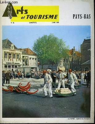
DESMETTRE Pierre & COLLECTIF
Arts et Tourisme N°20 : Pays-Bas.
O.V.P. EDITIONS. Avril 1970. In-4. Broché. Bon état, Couv. convenable, Dos satisfaisant, Intérieur frais. 37 pages. Nombreuses photos en noir et blanc dans le texte et hors-texte. Couverture en couleurs. Une carte en noir et blanc, hors-texte.. . . . Classification Dewey : 949.2-Pays Bas
Bookseller reference : RO80021934
|
|
|
Detels Holland
Oxford Textbook Of Public Health 3 Volume Set
Oxford University Press 1997. 3rd. Hardcover. Like New/Like New. Oxford University Press hardcover
Bookseller reference : 0192625535 ISBN : 0192625535 9780192625533
|
|
|
Detels Roger Holland Walter W Msewan James Omenn Gilbert S
Oxford Textbook Of Public Health
Oxford University Press 1997. 3rd edition. Hardback. Cloth F. 3 volumes total of 1649pp indeces many text figs & tables a nice clean as new set. The three volumes are - 1 Scope of Public Health 2 Methods of Public Health 3 Practice of Public Health. In Print at �350. Oxford University Press hardcover
Bookseller reference : 11268
|
|
|
DEURSEN, A. TH. van
GRAFT - Ein Dorf im 17. Jahrhundert
Göttingen, Steidl Verlag, 1997. Hardcover mit Schutzumschlag, 8°, 427 S., 1. Auflage, mit zahlr. Abbildungen auf Tafeln, aus dem Niederländischen von Stefanie Peter, »Mit der Vorstellung vom Dorfleben in früheren Epochen verbinden sich häufig ebenso romantisch verklärte wie zynische Klischees. Am Beispiel von Graft, einem unscheinbaren Ort an der nordholländischen Küste, zeichnet der Autor ein ganz anderes, überraschendes Bild der Dorfgemeinschaft - eine Frühform des niederländischen Wohlfahrtsstaates.«
Bookseller reference : C2679

|
|
|
Deutschmann Charles Otto Gunmaker of 8 Nag's Head Rd Ponder's End & James Park of 140 Holland St Glasgow:
Improvements in Positive Endless Band Driving Gear
HMSO 11896 AN ORIGINAL PATENT pub at 8d pp 3 folding plate Roy 8vo unboun d indelible stamps HMSO 11896 unknown
Bookseller reference : 6624
|
|
|
DEVAUX, Pierre
LA LANGUE VERTE suivie des PROPOS DE L"AFFRANCHI, avec des illustrations de l"auteur.
Paris, Emile Hazan, sans date, un volume in-12 broché, couverture rose illustrée rempliée, 129 pages. Dos très abimé avec des manques, "réparé" au scotch transparent, 2ème plat sali avec accroc sans manques près du dos, réparé de l"intérieur. Bon état intérieur. Cet exemplaire mériterait une reliure, et les couvertures pourraient être conservées. Exemplaire numéroté 1/40 sur Hollande (tête) , ENVOI autographe signé de l"auteur.
Bookseller reference : 6074
|
|
|
Dewey Frederick Holland
CAESAR'S COMMENTARIES ON THE GALLIC WAR - BOOKS I - VII
Translation Publishing Co. Inc. Very Good with no dust jacket; Dust stained top edge. Small spot of . whitish discoloration on rear. Tiny hole in cloth of front joint. Clean . . No DJ. 11-4. 1918. Hardcover. 8vo 8" - 9" tall . Translation Publishing Co., Inc. hardcover
Bookseller reference : 71618
|
|
|
Dewey Frederick Holland
Caesar's Commentaries on the Gallic War Books I - VII
Translation Publ. Co 1918. No Additional Printings Listed. Hardcover. Near Fine/No Jacket. NOT an ex library book. Dark green cloth covered book has print and decoration in gold on the spine. 500 clean interior pages. Translation Publ. Co hardcover
Bookseller reference : 133254
|
|
|
Dewey Frederick Holland
Caesar's Commentaries on the Gallic War - Books I - VII
Translation Publishing Co. Inc 1918-01-01. Hardcover. Very Good. Translation Publishing Co., Inc hardcover
Bookseller reference : 150926127
|
|
|
Dewey Frederick Holland
Cicero's Selected Orations
New York: Translation Publishing Co 1916 book is tight with no markings some light tanning to page edges boards have some rubbing . Hard Cover. Good/No Jacket. 12mo - over 6�" - 7�" tall. Translation Publishing Co hardcover
Bookseller reference : 022861

|
|
|
Dewey Frederick Holland; Frederick Holland Dewey A. B
Cicero's Selected Orations: The Original Latin Text With an Interlinear English Translation
New York: Translation Publishing Co. Inc. 1916. Decorative Canvas Hardcover. Very Good/No Jacket. 12mo or 12� Duodecimo: 6�" x 7�" tall. 232 pp. Nearly flawless copy with minimal external wear crisp pages and clean text. Solidly bound copy with smooth covers. Light foxing on page edges. <br/> <br/> Translation Publishing Co., Inc. hardcover
Bookseller reference : 4iiBe0024
|
|
|
Dewey Frederick Holland
Virgil's Aeneid Books I-VI Interlinear translation
New York: The Translation Publishing Co. 1917 1917. Hardcover. Acceptable. Disclaimer:A readable copy. All pages are intact and the cover is intact. Pages can include considerable notes-in pen or highlighter-but the notes cannot obscure the text. The dust jacket is missing. At ThriftBooks our motto is: Read More Spend Less. New York: The Translation Publishing Co. 1917 hardcover
Bookseller reference : GB000MBR4SII5N01

|
|
 Receive by email
 Download as PDF document
 RSS feed


