|
Southern Pacific Lines San Francisco Calif.
Map of Reno Washoe County NV
Ogden Utah: Southern Pacific Company 1928 rev. 1948. Blueline print 24 inches x 56 inches. From Nevada Street and Fourth Street to H Street and Overland Street. Listing of signals and spurs. No industries indicated. With Humphrey Tract East Reno Heights. 1 inch = 100 feet. Ogden, Utah: Southern Pacific Company, 1928, rev. 1948 unknown
Bookseller reference : 58-0489

|
|
|
Southern Pacific Lines San Francisco Calif.
Map of Reno Washoe County NV
Ogden Utah: Southern Pacific Company. Blueprint 19 inches x 29 inches. From Park Street and Fourth Street to Seventh Street. Note on sketch reads "With exception industries marked B-C-L-N Western Pacific have placed or spotted competitive loads on which southern pacific enjoyed line haul. Tracks serving these industries should be classified." Not drawn to scale. Ogden, Utah: Southern Pacific Company unknown
Bookseller reference : 58-0482

|
|
|
Southern Pacific Lines San Francisco Calif.
Map of Reno Washoe County NV
Ogden Utah: Southern Pacific Company 1928 rev. 1933. Blueprint 24 inches x 54 inches. From Vine Street to Surprise Valley Road. With typewritten Index to Industry 17 listings indexed by letter. With Reno Flour Mill Home Lumber Co Swift & Co PHP. Scale 1 inch = 100 feet. Ogden, Utah: Southern Pacific Company, 1928, rev. 1933 unknown
Bookseller reference : 58-0483

|
|
|
Southern Pacific Lines San Francisco Calif.
Map of Reno Washoe County NV
Ogden Utah: Southern Pacific Company 1928. Blueprint 24 inches x 55 inches. From Surprise Valley Road to Nevada Street. With typewritten Index to Industry 32 listings indexed by letter with description of type of industry. With Union Paving Co Nevada Transfer and Wholesale Smith & Peterson. Scale 1 inch = 100 feet. Ogden, Utah: Southern Pacific Company, 1928 unknown
Bookseller reference : 58-0484

|
|
|
Southern Pacific Lines San Francisco Calif.
Map of Reno Washoe County NV
Ogden Utah: Southern Pacific Company 1928 rev. 1947. Blueline print 24 inches x 56 inches. From Vine Street to 3800 feet west of City Limits. With red pencilling indicating switching limits. With detailed listing of spurs and signals. Scale 1 inch = 100 feet. Ogden, Utah: Southern Pacific Company, 1928, rev. 1947 unknown
Bookseller reference : 58-0486

|
|
|
Southern Pacific Lines San Francisco Calif.
Map of Sage Riverside County CA
San Francisco Calif.: Southern Pacific Company 1960. Blueline print 24 inches x 55 inches. Sheet two of two. From Deming Vegetable Co-op Warehouse and 1/2 mile west to 3500 feet south. Includes railroad tracks spurr tracks track measurements no other structures than warehouse. Scale 1 inch = 100 feet. San Francisco, Calif.: Southern Pacific Company, 1960 unknown
Bookseller reference : 58-0551

|
|
|
Southern Pacific Lines San Francisco Calif.
Map of Sage Riverside County CA
San Francisco Calif.: Southern Pacific Company 1960. Blueline print 24 inches x 55 inches. Sheet one of two. From station point Sage to one mile south. Includes railroad tracks road no structures. Scale 1 inch = 100 feet. San Francisco, Calif.: Southern Pacific Company, 1960 unknown
Bookseller reference : 58-0550

|
|
|
Southern Pacific Company
Map of San Francisco: Showing points of special interest to attendants the Fifth International Convention of the Epworth League July 18-21 1901
<p>Map of San Francisco: Showing points of special interest to attendants the Fifth International Convention of the Epworth League July 18-21 1901 folding map of 21" x 28" printed in black & red.With numbered locations of places of Methodist interest and historical. Verso of map with 23 panels detailing trips excursions to Yosemite Valley Southern California including Pasadena Redlands Riverside Palo Alto Santa Cruz Lick Observatory. Very good minor wear; short tears at folds.</p><p>San Francisco before the 1906 devastating earthquake.</p> unknown
Bookseller reference : 2221875

|
|
|
Southern Pacific Lines San Francisco Calif.
Map of San Jose Santa Clara County California
San Francisco Calif.: Southern Pacific Company 1929 revised 1940. Map. Blueline print 25" x 68". From Maple St to Hillsdale Ave and Lick. Includes former town of Willow Glen Lewis Canal Washington Square Oakhill Cemetery. Scale 1" = 500'. San Francisco, Calif.: Southern Pacific Company, 1929, revised 1940 unknown
Bookseller reference : 56-0293

|
|
|
Southern Pacific Lines San Francisco Calif.
Map of San Jose Santa Clara County California
San Francisco Calif.: Southern Pacific Company 1933. Map. Blueline print 27" x 68.5" with red black and mauve outline and pencilling . From Maple St to Hillsdale Ave and Lick. Includes former College of the Pacific Southern Pacific Yards Willow Glen Washington Square Oakhill Cemetery. Scale 1" = 500'. San Francisco, Calif.: Southern Pacific Company, 1933? unknown
Bookseller reference : 56-0292

|
|
|
Southern Pacific Lines San Francisco Calif.
Map of San Francisco Waterfront San Francisco County CA
San Francisco Calif.: Southern Pacific Company 1932. Blueprint 23 inches x 55 inches. From Kearny Street to Van Ness Avenue Fisherman's Wharves to Francisco Streets. Proposed Operation of State Belt Railroad over Souther Pacific Company's Track on Beach Street. With red yellow and green lines indicating new connection tracks abandoned tracks current tracks. Scale 1 inch = 100 feet. San Francisco, Calif.: Southern Pacific Company, 1932 unknown
Bookseller reference : 58-0498

|
|
|
Southern Pacific Lines San Francisco Calif.
Map of San Francisco Waterfront San Francisco County CA
San Francisco Calif.: Board of State Harbor Commissioners n.d. Blueline print 50 inches x 11 feet. Several small tears no missing material. From Twenty-fourth Street to Ferry Building Mission Rock to Van Ness Avenue Kansas Street. With inset map of The Presidio. No scale indicated. San Francisco, Calif.: Board of State Harbor Commissioners, [n.d.] unknown
Bookseller reference : 58-0491

|
|
|
Southern Pacific Lines San Francisco Calif.
Map of Shell Point West Pittsburg Contra Costa County California
Oakland Calif.: Southern Pacific Company 1933. Map. Blueprint 24" x 55". As 56-0308 with additional extensive red pencil notes detailing use and state of various tracks. Proposed Trackage to serve Shell Chemical Co. Includes Poinsetta Land Co Pittsburg Ave Sacto Northern Railway line Bella Monte Subdivision Scale 1" = 100'. Oakland, Calif.: Southern Pacific Company, 1933 unknown
Bookseller reference : 56-0309

|
|
|
Southern Pacific Lines San Francisco Calif.
Map of Shell Point West Pittsburg Contra Costa County California
Oakland Calif.: Southern Pacific Company 1933. Map. Blueprint 24" x 55". Proposed Trackage to serve Shell Chemical Co. Includes Poinsetta Land Co Pittsburg Ave Sacto Northern Railway line Bella Monte Subdivision Scale 1" = 100'. Oakland, Calif.: Southern Pacific Company, 1933 unknown
Bookseller reference : 56-0308

|
|
|
Southern Pacific Lines San Francisco Calif.
Map of Stockton Fresno County California
San Francisco Calif.: Thomas Bros Maps addition of switching zones approved 1961. Map. Blueline print 24" x 19" with orange green red and brown pencilling indicating switching zones. From French Camp to Eight Mile and Bucley Cove to Windsor. With index to streets and points of interest on back. Scale approx 1" = 0.5 mile. San Francisco, Calif.: Thomas Bros Maps, addition of switching zones approved 1961 unknown
Bookseller reference : 56-0336

|
|
|
Southern Pacific Lines San Francisco Calif.
Map of Stockton Port District and Vicinity Developement Fresno County California
San Francisco Calif.: Southern Pacific Company 1945. Map. Blueprint 12" x 39". Faded but legible. From Burns Cut Off to Mormon Channel. Includes Stockton Deep Water Channel Country Club Turning Basin. Scale 1" = 800'. San Francisco, Calif.: Southern Pacific Company, 1945 unknown
Bookseller reference : 56-0329

|
|
|
Southern Pacific Lines San Francisco Calif.
Map of Susanville Lassen County California
Ogden Utah: Southern Pacific Company 1929. Map. Blueprint 24" x 55" From Tulare Street to Richmond Road and Lassen Street. Includes legend of buildings in Lassen Lumber and Box Company and Fruit Growers' Supply Company. With extensive overlapping land use notes. Scale 1" = 200'. Ogden, Utah: Southern Pacific Company, 1929 unknown
Bookseller reference : 56-0337

|
|
|
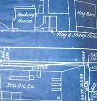
Southern Pacific Lines San Francisco Calif.
Map of Susanville Lassen County California
Ogden Utah: Southern Pacific Company 1933. revised 1936. Map. Blueprint 8" x 39". Includes Susan River Standard Oil Co and Cattle Hog and Sheep Yards. No buildings other than Standard Oil and animal yards. Scale 1" = 100'. Ogden, Utah: Southern Pacific Company, 1933. revised 1936 unknown
Bookseller reference : 56-0338
|
|
|
Southern Pacific Lines San Francisco Calif.
Map of the City of Fresno and Vicinity Fresno County CA
Fresno Calif.: Chamber of Commerce n.d. Blueline print 36" x 24" Marks Avenue to Willow Avenue and Annadale Avenue to Barstow Avenue. Red and yellow pencil shading highlight City Limits. With Central District map and street index approx 400 listings on back. Scale approx 1 inch = 0.3 mile. Fresno, Calif.: Chamber of Commerce, [n.d.] unknown
Bookseller reference : 56-0438

|
|
|
Southern Pacific Lines San Francisco Calif.
Map of Trucking Operations Southwestern US
Tucson Ariz.: Pacific Motor Trucking Company 1932 revised 1934. Map. Blueline print 33.5" x 32.5" with red and green lines and circles indicating first morning and afternoon L.C.L. shipments from Los Angeles or Bay Area. From Colombia River at Pacific Ocean to El Paso. Scale approx 1 inch = 40 miles. Tucson, Ariz.: Pacific Motor Trucking Company, 1932, revised 1934 unknown
Bookseller reference : 56-0363

|
|
|
Southern Pacific Lines San Francisco Calif.
Map of Trucking Operations Southwestern US
Tucson Ariz.: Pacific Motor Trucking Company 1949. Map. Blueline print 31" x 35" with red yellow and blue highlighting indicating Southern Pacific rail lines and Pacific Motor rights of passage. From Colombia River to El Paso. Scale approx 1 inch = 35 miles. Tucson, Ariz.: Pacific Motor Trucking Company, 1949 unknown
Bookseller reference : 56-0362

|
|
|
Southern Pacific Lines San Francisco Calif.
Map of Visalia Tulare County California
San Francisco Calif.: Southern Pacific Company 1921 revised 1936. Map. Blueprint 24" x 62". From West Street to beyond Mill Creek. Includes Southern California Edison Co Material Yard for County of Tulare original townsite Brown's Addition Drouillard's Addition Spaulding Lumber Co. Scale 1" = 100'. San Francisco, Calif.: Southern Pacific Company, 1921, revised 1936 unknown
Bookseller reference : 56-0355

|
|
|
Southern Pacific Lines San Francisco Calif.
Map Show Switching Zones of Southern Pacific at Los Angeles
San Francisco Calif.: Southern Pacific Railroad July 19 1928. Map. From Burbank through Glendale to Firestone Park at the southern portion. San Francisco, Calif.: Southern Pacific Railroad, July 19, 1928 unknown
Bookseller reference : 01-0065

|
|
|
Southern Pacific Lines San Francisco Calif.
Map Show Switching Zones of Southern Pacific at Los Angeles
San Francisco Calif.: Southern Pacific Railroad April 2 1929. Map. From Burbank through Glendale to Firestone Park at the southern portion. San Francisco, Calif.: Southern Pacific Railroad, April 2, 1929 unknown
Bookseller reference : 01-0061
|
|
|
SOUTHERN PACIFIC
Maps and Description Shasta Route Portland - San Francisco. SP. The friendly Southern Pacific. TOGETHER WITH Southern Pacific Shasta Route Time Tables.
1947/ 1948. LOT OF THREE ITEMS one fold pamphlet 11 pp two duplicate time tables. Very good condition. Timetables are marked Form D October 3 1948. . unknown
Bookseller reference : 30876
|
|
|
Southern Pacific Lines San Francisco Calif.
Martinez - Antioch Switching Zone Map California
San Francisco Calif.: Southern Pacific Company 1931. Map. Blackline print. 12 x 56 inches. Purple orange and green highlighting. With Redwood Manufacturers Co Diamond Building Material Co Phoenix Rubber Mills etc. Scale: 1 inch = 2000 feet. San Francisco, Calif.: Southern Pacific Company, 1931 unknown
Bookseller reference : 56-0210

|
|
|
Southern Pacific Lines San Francisco Calif.
Martinez-Antioch. Present and Proposed Switching Zones. Map
Southern Pacific Railroad July 9 1956. Map. Blueprint. 24 x 68 inches. Scale: 1 inch = 2000 feet. Southern Pacific Railroad, July 9, 1956 unknown
Bookseller reference : 01-0069
|
|
|
Southern Pacific Lines San Francisco Calif.
Martinez-Antioch. Switching Zone Map
San Francisco Calif.: Southern Pacific Railroad March 20 1953. Map. Blueprint. 22 x 56 inches. Scale: 1 inch = 2000 feet. San Francisco, Calif.: Southern Pacific Railroad, March 20, 1953 unknown
Bookseller reference : 01-0068
|
|
|
Southern Pacific Lines San Francisco Calif.
Martinez. Proposed Switching Limited. Map
San Francisco Calif.: Southern Pacific Railroad November 1931. Map. Blueprint. 8 x 26 inches. Scale 1 inch = 1000 feet. San Francisco, Calif.: Southern Pacific Railroad, November, 1931 unknown
Bookseller reference : 01-0070
|
|
|
Southern Pacific Company.
Minerals for Industry : Northern Nevada and Northwestern Utah : Summary of Geological Survey of 1955 - 1961. Volume I.
Southern Pacific Company. 1964. Book. Very Good. Soft cover. ORIGINAL PUBLICATION; contains the three large folded maps in rear pocket complete for this publication; softcovers comb-bound; ex-corporate library; light tanning of leaves; o/w in very good condition. This is a heavy item; extra shipping might be required for priority mail or international orders. . Southern Pacific Company. Paperback
Bookseller reference : 030410
|
|
|
Southern Pacific Company.
Minerals for Industry: Summary of Geological Survey of 1955-1961. 3 Volumes. Volume I: Northern Nevada and Northwestern Utah; Volume II: Northern California; Volume III: Southern California.
San Francisco. : Southern Pacific Company. 1964. Plastic comb bindings pictorial covers. . Comb bindings damaged and brittle owner’s name to covers otherwise very good. . Three volumes complete. Requires extra postage. 9 folding maps in pockets. Southern Pacific Company. unknown
Bookseller reference : 288201

|
|
|
Southern Pacific Company
Minerals for industry : summary of geological survey of 1955-1961
Used - Good. 1964 illus. maps part fold. in pockets . 3v. Former Library book. Includes bibliographies. Shows some signs of wear and may have some markings on the inside. unknown
Bookseller reference : GRP85492415
|
|
|
Southern Pacific Company.
Minerals for Industry : Northern California. Summary of Geological Survey of 1955 - 1961. Volume II.
Southern Pacific Company. 1964. Book. Very Good. Soft cover. Softcovers; includes two folded maps in rear pocket complete for this publication; comb-bound; ex-corporate library; in very good condition. . Southern Pacific Company. Paperback
Bookseller reference : 017930
|
|
|
Southern Pacific Company.
Minerals for Industry : Northern California. Summary of Geological Survey of 1955 - 1961. Volume II.
Southern Pacific Company. 1964. Book. Good. Soft cover. Softcovers; includes two folded maps in rear pocket complete for this publication; comb-bound; ex-corporate library; several plastic binding teeth broken; light creasing of upper corner of leaves; o/w in good condition. . Southern Pacific Company. Paperback
Bookseller reference : 017903
|
|
|
Southern Pacific Co
Minerals for Industry Northern California; Summary of Geological Survey of 1955-1961 Volume II
Southern Pacific Company 1964. Heavy card stock. Very Good/None as issued. Clean tight 4to 207pp map pocket in back with map intact. Spiral bound. Part I - Northern Sierra Nevada Part II Klamath Mountains and Cascade Range.Compilation of Mineral Commodities; classification method of listing; limitations. Metallics industrial rocks and minerals. <br/><br/> Southern Pacific Company unknown
Bookseller reference : 16408
|
|
|
Southern Pacific Company
No. 2958. In the of United States circuit court of appeals for the ninth circuit. Southern Pacific Company et al. appellants vs. United States of America appellee. In equity. Brief of United States appellee 1910 Leather Bound
2019. Leather Bound. New. Leather Binding on Spine and Corners with Golden Leaf Printing on round Spine. Reprinted in 2019 with the help of original edition published long back 1910. This book is printed in black & white sewing binding for longer life Printed on high quality Paper re-sized as per Current standards professionally processed without changing its contents. As these are old books we processed each page manually and make them readable but in some cases some pages which are blur or missing or black spots. If it is multi volume set then it is only single volume if you wish to order a specific or all the volumes you may contact us. We expect that you will understand our compulsion in these books. We found this book important for the readers who want to know more about our old treasure so we brought it back to the shelves. Hope you will like it and give your comments and suggestions. Lang: - eng Pages 478. EXTRA 10 DAYS APART FROM THE NORMAL SHIPPING PERIOD WILL BE REQUIRED FOR LEATHER BOUND BOOKS. FOLIO EDITION IS ALSO AVAILABLE. hardcover
Bookseller reference : LB1111000428524

|
|
|
Southern Pacific Company.
No. 2958. In the of United States circuit court of appeals for the ninth circuit. Southern Pacific Company et al. appellants vs. United States of America appellee. In equity. Brief of United States appellee. 1910
2020. Paperback. New. Lang: - eng Pages 468. Reprinted in 2020 with the help of original edition published long back 1910. This book is Printed in black & white sewing binding for longer life with Matt laminated multi-Colour Soft Cover HARDCOVER EDITION IS ALSO AVAILABLE Printed on high quality Paper re-sized as per Current standards professionally processed without changing its contents. As these are old books we processed each page manually and make them readable but in some cases some pages which are blur or missing or black spots. If it is multi volume set then it is only single volume if you wish to order a specific or all the volumes you may contact us. We expect that you will understand our compulsion in these books. We found this book important for the readers who want to know more about our old treasure so we brought it back to the shelves. Any type of Customisation is possible with extra charges. Hope you will like it and give your comments and suggestions. paperback
Bookseller reference : PB1111009171931
|
|
|
Southern Pacific Company.
No. 2958. In the of United States circuit court of appeals for the ninth circuit. Southern Pacific Company et al. appellants vs. United States of America appellee. In equity. Brief of United States appellee. 1910
2020. Paperback. New. Lang: - eng Pages 474. Reprinted in 2020 with the help of original edition published long back 1910. This book is Printed in black & white sewing binding for longer life with Matt laminated multi-Colour Soft Cover HARDCOVER EDITION IS ALSO AVAILABLE Printed on high quality Paper re-sized as per Current standards professionally processed without changing its contents. As these are old books we processed each page manually and make them readable but in some cases some pages which are blur or missing or black spots. If it is multi volume set then it is only single volume if you wish to order a specific or all the volumes you may contact us. We expect that you will understand our compulsion in these books. We found this book important for the readers who want to know more about our old treasure so we brought it back to the shelves. Any type of Customisation is possible with extra charges. Hope you will like it and give your comments and suggestions. paperback
Bookseller reference : PB1111009171930
|
|
|
Southern Pacific Company.
No. 2958. In the of United States circuit court of appeals for the ninth circuit. Southern Pacific Company et al. appellants vs. United States of America appellee. In equity. Brief of United States appellee. 1910 Hardcover
2020. Hardcover. New. Lang: - eng Pages 468. Reprinted in 2020 with the help of original edition published long back 1910. This book is Printed in black & white Hardcover sewing binding for longer life with Matt laminated multi-Colour Dust Cover Printed on high quality Paper re-sized as per Current standards professionally processed without changing its contents. As these are old books we processed each page manually and make them readable but in some cases some pages which are blur or missing or black spots. If it is multi volume set then it is only single volume if you wish to order a specific or all the volumes you may contact us. We expect that you will understand our compulsion in these books. We found this book important for the readers who want to know more about our old treasure so we brought it back to the shelves. Any type of Customisation is possible with extra charges. Hope you will like it and give your comments and suggestions. hardcover
Bookseller reference : 1111009171931
|
|
|
Southern Pacific Company.
No. 2958. In the of United States circuit court of appeals for the ninth circuit. Southern Pacific Company et al. appellants vs. United States of America appellee. In equity. Brief of United States appellee. 1910 Hardcover
2020. Hardcover. New. Lang: - eng Pages 474. Reprinted in 2020 with the help of original edition published long back 1910. This book is Printed in black & white Hardcover sewing binding for longer life with Matt laminated multi-Colour Dust Cover Printed on high quality Paper re-sized as per Current standards professionally processed without changing its contents. As these are old books we processed each page manually and make them readable but in some cases some pages which are blur or missing or black spots. If it is multi volume set then it is only single volume if you wish to order a specific or all the volumes you may contact us. We expect that you will understand our compulsion in these books. We found this book important for the readers who want to know more about our old treasure so we brought it back to the shelves. Any type of Customisation is possible with extra charges. Hope you will like it and give your comments and suggestions. hardcover
Bookseller reference : 1111009171930
|
|
|
Southern Pacific Company
No. 2958. In the of United States circuit court of appeals for the ninth circuit. Southern Pacific Company et al. appellants vs. United States of America appellee. In equity. Brief of United States appellee 1910
2020. Paperback. New. Lang: - eng Pages 478. Reprinted in 2020 with the help of original edition published long back 1910. This book is Printed in black & white sewing binding for longer life with Matt laminated multi-Colour Soft Cover HARDCOVER EDITION IS ALSO AVAILABLE Printed on high quality Paper re-sized as per Current standards professionally processed without changing its contents. As these are old books we processed each page manually and make them readable but in some cases some pages which are blur or missing or black spots. If it is multi volume set then it is only single volume if you wish to order a specific or all the volumes you may contact us. We expect that you will understand our compulsion in these books. We found this book important for the readers who want to know more about our old treasure so we brought it back to the shelves. Any type of Customisation is possible with extra charges. Hope you will like it and give your comments and suggestions. paperback
Bookseller reference : PB1111000428524
|
|
|
Southern Pacific Company
No. 2958. In the of United States circuit court of appeals for the ninth circuit. Southern Pacific Company et al. appellants vs. United States of America appellee. In equity. Brief of United States appellee 1910 Hardcover
2020. Hardcover. New. Lang: - eng Pages 478. Reprinted in 2020 with the help of original edition published long back 1910. This book is Printed in black & white Hardcover sewing binding for longer life with Matt laminated multi-Colour Dust Cover Printed on high quality Paper re-sized as per Current standards professionally processed without changing its contents. As these are old books we processed each page manually and make them readable but in some cases some pages which are blur or missing or black spots. If it is multi volume set then it is only single volume if you wish to order a specific or all the volumes you may contact us. We expect that you will understand our compulsion in these books. We found this book important for the readers who want to know more about our old treasure so we brought it back to the shelves. Any type of Customisation is possible with extra charges. Hope you will like it and give your comments and suggestions. hardcover
Bookseller reference : 1111000428524
|
|
|
Southern Pacific Company Creator
No. 2958. in the of United States Circuit Court of Appeals for the Ninth Circuit. Southern Pacific Company Et Al. Appellants Vs. United States of . in Equity. Brief of United States Appellee
HardPress Publishing 2012-08-01. Paperback. Good. HardPress Publishing paperback
Bookseller reference : SONG1290583234 ISBN : 1290583234 9781290583237

|
|
|
SOUTHERN PACIFIC ATLANTIC STEAMSHIP LINES
One Hundred Golden Hours At Sea
New York: 1910. First Edition. narrow 8vo. pp. 36 4. 2 tipped-in colour plates 2 full-page maps & numerous text illus. uncut. wrs. deep scratch in front wr [New York: 1910] unknown
Bookseller reference : elala4892
|
|
|
SOUTHERN PACIFIC RAILROAD OREGON.
Oregon outdoors. Southern Pacific Lines. The summerland -- beautiful.
Portland OR: Passenger Traffic Department Southern Pacific Lines Irwin-Hodson Co. March 11 1925. 4to. Printed & bound in double-columns center fold. 32 pp. Numerous text illustrations photo illustrations double-page colour centerfold of Crater Lake National Park maps. Colour-illustrated softcovers beautiful Jazz Age cover art of hikers amongst the mountains & forest slight shelfwear very slight rubbing VG copy. Early printing of this wonderfully illustrated promotional travel brochure for the Southern Pacific including wonderful photo illustrations of hotels motels attractions beaches and more. Passenger Traffic Department, Southern Pacific Lines, Irwin-Hodson Co., paperback
Bookseller reference : 48473
|
|
|
Southern Pacific Railroad Company
Organization articles of association and consolidation : and acts of Congress and of the Legislature of the State of California relative thereto : compiled from authentic sources 1875 Leather Bound
2019. Leather Bound. New. Leather Binding on Spine and Corners with Golden Leaf Printing on round Spine. Reprinted in 2019 with the help of original edition published long back 1875. This book is printed in black & white sewing binding for longer life Printed on high quality Paper re-sized as per Current standards professionally processed without changing its contents. As these are old books we processed each page manually and make them readable but in some cases some pages which are blur or missing or black spots. If it is multi volume set then it is only single volume if you wish to order a specific or all the volumes you may contact us. We expect that you will understand our compulsion in these books. We found this book important for the readers who want to know more about our old treasure so we brought it back to the shelves. Hope you will like it and give your comments and suggestions. Lang: - eng Pages 136. EXTRA 10 DAYS APART FROM THE NORMAL SHIPPING PERIOD WILL BE REQUIRED FOR LEATHER BOUND BOOKS. FOLIO EDITION IS ALSO AVAILABLE. hardcover
Bookseller reference : LB1111000452264
|
|
|
Southern Pacific Railroad Company.
Organization articles of association and consolidation : and acts of Congress and of the Legislature of the State of California relative thereto : compiled from authentic sources. 1875 Hardcover
2020. Hardcover. New. Lang: - eng Pages 132. Reprinted in 2020 with the help of original edition published long back 1875. This book is Printed in black & white Hardcover sewing binding for longer life with Matt laminated multi-Colour Dust Cover Printed on high quality Paper re-sized as per Current standards professionally processed without changing its contents. As these are old books we processed each page manually and make them readable but in some cases some pages which are blur or missing or black spots. If it is multi volume set then it is only single volume if you wish to order a specific or all the volumes you may contact us. We expect that you will understand our compulsion in these books. We found this book important for the readers who want to know more about our old treasure so we brought it back to the shelves. Any type of Customisation is possible with extra charges. Hope you will like it and give your comments and suggestions. hardcover
Bookseller reference : 1111012760497
|
|
|
Southern Pacific Railroad Company.
Organization articles of association and consolidation : and acts of Congress and of the Legislature of the State of California relative thereto : compiled from authentic sources. 1875
2020. Paperback. New. Lang: - eng Pages 132. Reprinted in 2020 with the help of original edition published long back 1875. This book is Printed in black & white sewing binding for longer life with Matt laminated multi-Colour Soft Cover HARDCOVER EDITION IS ALSO AVAILABLE Printed on high quality Paper re-sized as per Current standards professionally processed without changing its contents. As these are old books we processed each page manually and make them readable but in some cases some pages which are blur or missing or black spots. If it is multi volume set then it is only single volume if you wish to order a specific or all the volumes you may contact us. We expect that you will understand our compulsion in these books. We found this book important for the readers who want to know more about our old treasure so we brought it back to the shelves. Any type of Customisation is possible with extra charges. Hope you will like it and give your comments and suggestions. paperback
Bookseller reference : PB1111012760497
|
|
|
Southern Pacific Railroad Company
Organization articles of association and consolidation : and acts of Congress and of the Legislature of the State of California relative thereto : compiled from authentic sources 1875
2020. Paperback. New. Lang: - eng Pages 136. Reprinted in 2020 with the help of original edition published long back 1875. This book is Printed in black & white sewing binding for longer life with Matt laminated multi-Colour Soft Cover HARDCOVER EDITION IS ALSO AVAILABLE Printed on high quality Paper re-sized as per Current standards professionally processed without changing its contents. As these are old books we processed each page manually and make them readable but in some cases some pages which are blur or missing or black spots. If it is multi volume set then it is only single volume if you wish to order a specific or all the volumes you may contact us. We expect that you will understand our compulsion in these books. We found this book important for the readers who want to know more about our old treasure so we brought it back to the shelves. Any type of Customisation is possible with extra charges. Hope you will like it and give your comments and suggestions. paperback
Bookseller reference : PB1111000452264
|
|
|
Southern Pacific Railroad Company
Organization articles of association and consolidation : and acts of Congress and of the Legislature of the State of California relative thereto : compiled from authentic sources 1875 Hardcover
2020. Hardcover. New. Lang: - eng Pages 136. Reprinted in 2020 with the help of original edition published long back 1875. This book is Printed in black & white Hardcover sewing binding for longer life with Matt laminated multi-Colour Dust Cover Printed on high quality Paper re-sized as per Current standards professionally processed without changing its contents. As these are old books we processed each page manually and make them readable but in some cases some pages which are blur or missing or black spots. If it is multi volume set then it is only single volume if you wish to order a specific or all the volumes you may contact us. We expect that you will understand our compulsion in these books. We found this book important for the readers who want to know more about our old treasure so we brought it back to the shelves. Any type of Customisation is possible with extra charges. Hope you will like it and give your comments and suggestions. hardcover
Bookseller reference : 1111000452264
|
|
 Receive by email
 Download as PDF document
 RSS feed


