|
Southern Pacific Lines San Francisco Calif.
Right of Way and Track Map of Yuma Yuma County Arizona and Vicinity
Tucson Ariz.: Southern Pacific Company 1942. Map. Blueline print 24" x 56" with red pencilling indicating present switching limits. From Colorado River and City of Yuma to Fortuna AZ. Includes Yuma East Yard Araby and Fortuna station points. With Schedule of Property listing approx. 60 transfers 1892-1942. Scale 1" = 1000'. Tucson, Ariz.: Southern Pacific Company, 1942 unknown
Bookseller reference : 56-0361

|
|
|
Southern Pacific Lines San Francisco Calif.
Right of Way and Track Map of Eugene Lake County OR - Coos Bay Branch to Myrtile Point
San Francisco Calif.: Southern Pacific Company n.d. Blueline print 24" x 56". From west of Oak Home addition and Solomon Zumwalt Donation Land east to Jackson Street. With western portion of City of Eugene F.P. Blair's Donation land claim Cooper's Plat Ross Plat McClaren's Plat. Scale approx 1" = 200'. San Francisco, Calif.: Southern Pacific Company, [n.d.] unknown
Bookseller reference : 56-0431

|
|
|
Southern Pacific Lines San Francisco Calif.
Right of Way and Track Map for San Diego and Arizona Railway Co F Street Line Chula Vista San Diego County CA
San Francisco Calif.: Southern Pacific Company 1920. Black ink drawing on vellum 24" x 56". From San Diego Bay and Fourteenth Street in National City to southern limits of Chula Vista. With National City Marlborough Heights San Diego Fruit Co. San Diego Land Co. plots San Diego Oil Products AT&SF Railyard. With Schedule of Property listing 10 transfers 1887-1920. Scale: 1" = 400'. San Francisco, Calif.: Southern Pacific Company, 1920 hardcover
Bookseller reference : 56-0418

|
|
|
Southern Pacific Lines San Francisco Calif.
Right of Way and Track Map of Firebaugh and Vicinity Fresno County California
San Francisco Calif.: Southern Pacific Company 1957. Map. Blueline print 24" x 55". Includes San Joaquin River station point Firebaugh with 35 buildings Miller and Lux subdivision plot. With Schedule of Property listing approx. 20 transfers 1888-1957. Scale 1" = 400'. San Francisco, Calif.: Southern Pacific Company, 1957 unknown
Bookseller reference : 56-0326

|
|
|
Southern Pacific Lines San Francisco Calif.
Right of Way and Track Map of Goose Lake Sugar Hill Alturas Modoc County CA
San Francisco Calif.: Southern Pacific Company 1939. Blueline print 24 inches x 55 inches. From approx 4 miles south to approx 3 miles north of Sugar Hill along Goose Lake and Railroad tracks. No structures indicated extensive listing of signal and track measurements. With Schedule of Property listing approx 20 transfers 1861-1939. Scale 1 inch = 1000 feet. San Francisco, Calif.: Southern Pacific Company, 1939 unknown
Bookseller reference : 58-0547

|
|
|
Southern Pacific Lines San Francisco Calif.
Right of Way and Track Map of Westwood Lassen County California
San Francisco Calif.: Southern Pacific Company 1930. Map. Blueline print. 24 x 56 inches. Includes station point Westwood track markings six blocks by two blocks of unmarked buildings between Cedar Street and Ash Street. With Schedule of Property listing 13 transfers 1899-1930. Scale: 1 inch = 400 feet. San Francisco, Calif.: Southern Pacific Company, 1930 unknown
Bookseller reference : 56-0376

|
|
|
Southern Pacific Lines San Francisco Calif.
Right of Way and Track Map of Klamath Falls Klamath County OR
Sacramento Calif.: Southern Pacific Company 1939. Blueline print 24" x 56". From California - Oregon State Line to Kirk. Includes Ewauna Park Texum Lot listings 1 1/2 miles south of Texum. Schedule of Property listing approx 15 transfers 1906 - 1939. Scale 1" = 400'. Sacramento, Calif.: Southern Pacific Company, 1939 unknown
Bookseller reference : 56-0455

|
|
|
Southern Pacific Lines San Francisco Calif.
Right of Way and Track Map of Los Medanos Contra Costa County California
San Francisco Calif.: Southern Pacific Company 1938. Map. Blueline print 24" x 56" with red pencil notation. Includes Los Medanos Sommerville Road Antioch. With Schedule of Property listing approx 20 transfers 1878-1938. Scale 1" = 400' San Francisco, Calif.: Southern Pacific Company, 1938 unknown
Bookseller reference : 56-0282

|
|
|
Southern Pacific Lines San Francisco Calif.
Right of Way and Track Map of Ravenswood and Henderson San Mateo County CA
San Francisco Calif.: Southern Pacific Company 1953. Blueline print 24" x 55". Five inch tear no missing material. From Plumas Avenue and Terminal Avenue in Henderson to Alameda County Line. With San Francisco Bay Drawbridge Ravenswood San Francisco Bay Rancho de Las Pulgas University Village. Includes Schedule of Property listing approx 20 transfers 1907-1953. Scale 1" = 400'. Includes insert showing details of structures at Ravenswood water pipes and train lines surrounded Hetch Hetchy. Scale 1" = 100'. San Francisco, Calif.: Southern Pacific Company, 1953 unknown
Bookseller reference : 56-0450

|
|
|
Southern Pacific Lines San Francisco Calif.
Right of Way and Track Map of Mulford Alameda County California
San Francisco Calif.: Southern Pacific Company 1960. Map. Blueline print 24" x 56" with red highlights. From Elmhurst to Rancho San Leandro border. Includes inset Index Map scale 1 inch = 2miles Elmurst to Santa Clara. With Schedule of Property listing approx. 20 transfers 1906-1946. Includes Scale 1" = 400'. San Francisco, Calif.: Southern Pacific Company, 1960 unknown
Bookseller reference : 56-0256

|
|
|
Southern Pacific Lines San Francisco Calif.
Right of Way and Track Map - Nogales Branch Santa Cruz County Arizona. Benson to Nogales. Set of Two
Tucson Ariz.: Southern Pacific Company 1923. Map. Blueline prints 24" x 56" and 24" x 28". Second map is missing northern half with tear along opposite edge. Map of Nogales railroad yard from north of Nogales to border with Mexico with Schedule of Property Acquisition Date Original Grantor/Grantee Instrument of Transfer and Remarks of Sale for approx. 35 transfers 1875-1946 Scale 1" = 400'. Tucson, Ariz.: Southern Pacific Company, 1923 unknown
Bookseller reference : 56-0242

|
|
|
Southern Pacific Lines San Francisco Calif.
Right of Way and Track Map of Luning Mineral County Nevada
San Francisco Calif.: Southern Pacific Company 1929. Map. Blueline print 24" x 56". Railroad track map of Luring and vicinity. Includes Shedule of Property of record of 5 transfers 1875-1929. Scale 1" = 400'. Includes small inset detail map of Luning no scale indicated. San Francisco, Calif.: Southern Pacific Company, 1929 unknown
Bookseller reference : 56-0279

|
|
|
Southern Pacific Lines San Francisco Calif.
Right of Way and Track Map of Barton Amador County CA and Vicinity
San Francisco Calif.: Southern Pacific Company 1927. Blueline print 24" x 65" and 6" x 8" addition with red lines indicating switching points. Detail of additional map affixed to original to indicate switching limits. From Fresno Avenue No. 8 to Las Palmas. With portion of Schedule of Propoerty approx. 50 incomplete listings of transfer 1924-1944. Includes Cincotta Bartonette Roessler and Las Palmas. Scale 1" = 400'. San Francisco, Calif.: Southern Pacific Company, 1927 unknown
Bookseller reference : 56-0402

|
|
|
Southern Pacific Lines San Francisco Calif.
Right of Way and Track Map of Burbank to Chatsworth Los Angeles County CA
San Francisco Calif.: Southern Pacific Company 1956. Blackline print 24 inches x 56 inches. From Woodman/Castro Avenue to Craner Avenue Magnolia Boulevard to Oxnard Street. Includes North Hollywood Kester Rancho Ex-Mission de San Fernando. With Schedule of Property listing approx 80 transfers 1893-1956. Scale 1 inch = 400 feet. San Francisco, Calif.: Southern Pacific Company, 1956 unknown
Bookseller reference : 58-0525

|
|
|
Southern Pacific Lines San Francisco Calif.
Right of Way and Track Map San Jose to Vasona Santa Clara County CA
San Francisco Calif.: Southern Pacific Company 1960. Blackline print 24 inches x 55 inches. From Barstow Tract past Los Gatos Creek and railroad tracks to Pollard Road in Vasona. Includes Vasona Campbell Los Gatos Creek gravel beds. With Schedule of Property listing approx 35 transfers 1877-1960. Scale 1 inch = 200 feet. San Francisco, Calif.: Southern Pacific Company, 1960 unknown
Bookseller reference : 58-0534

|
|
|
Southern Pacific Lines San Francisco Calif.
Right of Way and Track Map Pabrico Alameda County California
San Francisco Calif.: Calif. Southern Pacific Company 1926. Map. Blueprint 24" x 55". Complete map of Pabrico. Includes W.S. Dickey Clay Co. K. & L. Box Co. Scale 1" = 100'. San Francisco, Calif.:, Calif. Southern Pacific Company, 1926 unknown
Bookseller reference : 56-0245

|
|
|
Southern Pacific Lines San Francisco Calif.
Right of Way and Track Map from Binney Junction to Oroville Butte County California
San Francisco Calif.: Southern Pacific Company 1920. Map. Blueline print. 24 x 56 inches. Folded with red pencilling. Map from Binney Junction to Oroville with Schedule of Property Acquisition Date Original Grantor/Grantee Instrument of Transfer and Remarks of Sale for 15 transfers 1852-1915. Scale: 1 inch = 400 feet. San Francisco, Calif.: Southern Pacific Company, 1920 unknown
Bookseller reference : 56-0225

|
|
|
Southern Pacific Lines San Francisco Calif.
Right of Way and Track Map Watsonville Junction to Olympia Santa Cruz County California
San Francisco Calif.: Southern Pacific Company 1937. Map. Blueline print 24" x 55" with red pencil indicating switching limits. Includes Rancho de la Canada de Rincon discontinued station point Golf Links. From approx 4000' northwest of Golf Links to Coral St to the south-east. With schedule of Property listing appox 10 transfers 1875-1937. Scale 1" = 200'. San Francisco, Calif.: Southern Pacific Company, 1937 unknown
Bookseller reference : 56-0304

|
|
|
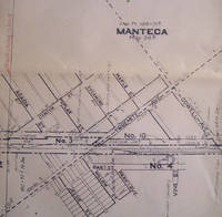
Southern Pacific Lines San Francisco Calif.
Right of Way and Track Map of Manteca San Joaquin County California
San Francisco Calif.: Southern Pacific Company 1934. Map. Blueline print 24" x 56" with red highlighting. Includes Manteca Morrano Calla and vicinity. With L.M. Larson's subdivision Spreckels Sugar Co. Spur. With Schedule of Property listing 17 transfers 1871-1934. Scale 1" = 400'. San Francisco, Calif.: Southern Pacific Company, 1934 unknown
Bookseller reference : 56-0263
|
|
|
Southern Pacific Lines San Francisco Calif.
Right of Way and Track Map of Alturas Modoc County California
San Francisco Calif.: Southern Pacific Company 1952. Blueline print 24 inches x 55 inches. From Alturas to California-Oregon State Line along railroad tracks and North Fork of Pitt River. No structures indicated extensive listing of signal and track measurements. With Schedule of Property listing approx 35 transfers 1875-1952. Scale: 1 inch = 1000 feet. San Francisco, Calif.: Southern Pacific Company, 1952 unknown
Bookseller reference : 58-0545

|
|
|
Southern Pacific Lines San Francisco Calif.
Right of Way and Track Map of West Glendale and Glendale Los Angeles County CA
San Francisco Calif.: Southern Pacific Company n.d. Blackline print 24 inches x 55 inches. From Glendale Boulevard and Irving Avenue to Brand Boulevard and Fernando Road. Includes Rancho San Rafael Rancho Los Felis West Glendale Glendale. Scale 1 inch = 400 feet. San Francisco, Calif.: Southern Pacific Company, [n.d.] unknown
Bookseller reference : 58-0529

|
|
|
Southern Pacific Lines San Francisco Calif.
Right of Way and Track Map of Antioch Jersey Newlove and Neroly Contra Costa County CA
San Francisco Calif.: Southern Pacific Company 1960. Blueline print 24 inches x 55 inches. From Abbot & Beade tract in Antioch to 4000 feet east of Station Point Neroly. With Frank Peabody's Subdivision Associated Pipe Line Company. Includes Schedule of Property listing approx 25 transfers 1872-1960. Scale: 1 inch = 400 feet. San Francisco, Calif.: Southern Pacific Company, 1960 unknown
Bookseller reference : 58-0541

|
|
|
Southern Pacific Company.
Road of a thousand wonders : Paso Robles Hot Springs the great hot springs resort of America / Southern Pacific. 1909
2020. Paperback. New. Lang: - eng Pages 52. Reprinted in 2020 with the help of original edition published long back 1909. This book is Printed in black & white sewing binding for longer life with Matt laminated multi-Colour Soft Cover HARDCOVER EDITION IS ALSO AVAILABLE Printed on high quality Paper re-sized as per Current standards professionally processed without changing its contents. As these are old books we processed each page manually and make them readable but in some cases some pages which are blur or missing or black spots. If it is multi volume set then it is only single volume if you wish to order a specific or all the volumes you may contact us. We expect that you will understand our compulsion in these books. We found this book important for the readers who want to know more about our old treasure so we brought it back to the shelves. Any type of Customisation is possible with extra charges. Hope you will like it and give your comments and suggestions. paperback
Bookseller reference : PB1111009324682
|
|
|
Southern Pacific Company.
Road of a thousand wonders : Paso Robles Hot Springs the great hot springs resort of America / Southern Pacific. 1909 Hardcover
2020. Hardcover. New. Lang: - eng Pages 52. Reprinted in 2020 with the help of original edition published long back 1909. This book is Printed in black & white Hardcover sewing binding for longer life with Matt laminated multi-Colour Dust Cover Printed on high quality Paper re-sized as per Current standards professionally processed without changing its contents. As these are old books we processed each page manually and make them readable but in some cases some pages which are blur or missing or black spots. If it is multi volume set then it is only single volume if you wish to order a specific or all the volumes you may contact us. We expect that you will understand our compulsion in these books. We found this book important for the readers who want to know more about our old treasure so we brought it back to the shelves. Any type of Customisation is possible with extra charges. Hope you will like it and give your comments and suggestions. hardcover
Bookseller reference : 1111009324682
|
|
|
Southern Pacific Company Pacific System
Rules and Regulations for the Government of Employes of the Operating Dept 1903 Leather Bound
2019. Leather Bound. New. Leather Binding on Spine and Corners with Golden Leaf Printing on round Spine. Reprinted in 2019 with the help of original edition published long back 1903. This book is printed in black & white sewing binding for longer life Printed on high quality Paper re-sized as per Current standards professionally processed without changing its contents. As these are old books we processed each page manually and make them readable but in some cases some pages which are blur or missing or black spots. If it is multi volume set then it is only single volume if you wish to order a specific or all the volumes you may contact us. We expect that you will understand our compulsion in these books. We found this book important for the readers who want to know more about our old treasure so we brought it back to the shelves. Hope you will like it and give your comments and suggestions. Lang: - English Pages 171. EXTRA 10 DAYS APART FROM THE NORMAL SHIPPING PERIOD WILL BE REQUIRED FOR LEATHER BOUND BOOKS. FOLIO EDITION IS ALSO AVAILABLE. hardcover
Bookseller reference : LB1111002266533
|
|
|
Southern Pacific Company WD. Lamprecht GenMan. W. D. n. Ma
Rules and Regulations of the Transportation Department
San Francisco CA: Southern Pacific Company Pacific Lines 1957. 202pp.; HB screw-bound2-hole; blk.embossno title on spine; rubbed w/wear on edges&corners; cleantight pgs. "The rules herein set forth govern the railroads operated by the Southern Pacific Company Pacific Lines. They supersede all previous rules and instructions inconsistent therewith." illus. Revised. Hard Cover. Very Good/No Jacket. 16mo - over 5�" - 6�" tall. Southern Pacific Company (Pacific Lines) Hardcover
Bookseller reference : 038836
|
|
|
Southern Pacific Company Pacific System
Rules and regulations for the government of employes of the Operating Dept. 1903 Hardcover
2020. Hardcover. New. Lang: - eng Pages 178. Reprinted in 2020 with the help of original edition published long back 1903. This book is Printed in black & white Hardcover sewing binding for longer life with Matt laminated multi-Colour Dust Cover Printed on high quality Paper re-sized as per Current standards professionally processed without changing its contents. As these are old books we processed each page manually and make them readable but in some cases some pages which are blur or missing or black spots. If it is multi volume set then it is only single volume if you wish to order a specific or all the volumes you may contact us. We expect that you will understand our compulsion in these books. We found this book important for the readers who want to know more about our old treasure so we brought it back to the shelves. Any type of Customisation is possible with extra charges. Hope you will like it and give your comments and suggestions. hardcover
Bookseller reference : 1111011764509
|
|
|
Southern Pacific Company.
Rules and instructions for the government of employes of the Maintenance of Way Department / adopted by the Southern Pacific Company. 1898
2020. Paperback. New. Lang: - eng Pages 208. Reprinted in 2020 with the help of original edition published long back 1898. This book is Printed in black & white sewing binding for longer life with Matt laminated multi-Colour Soft Cover HARDCOVER EDITION IS ALSO AVAILABLE Printed on high quality Paper re-sized as per Current standards professionally processed without changing its contents. As these are old books we processed each page manually and make them readable but in some cases some pages which are blur or missing or black spots. If it is multi volume set then it is only single volume if you wish to order a specific or all the volumes you may contact us. We expect that you will understand our compulsion in these books. We found this book important for the readers who want to know more about our old treasure so we brought it back to the shelves. Any type of Customisation is possible with extra charges. Hope you will like it and give your comments and suggestions. paperback
Bookseller reference : PB1111010546020
|
|
|
Southern Pacific Company.
Rules and instructions for the government of employes of the Maintenance of Way Department / adopted by the Southern Pacific Company. 1898 Hardcover
2020. Hardcover. New. Lang: - eng Pages 208. Reprinted in 2020 with the help of original edition published long back 1898. This book is Printed in black & white Hardcover sewing binding for longer life with Matt laminated multi-Colour Dust Cover Printed on high quality Paper re-sized as per Current standards professionally processed without changing its contents. As these are old books we processed each page manually and make them readable but in some cases some pages which are blur or missing or black spots. If it is multi volume set then it is only single volume if you wish to order a specific or all the volumes you may contact us. We expect that you will understand our compulsion in these books. We found this book important for the readers who want to know more about our old treasure so we brought it back to the shelves. Any type of Customisation is possible with extra charges. Hope you will like it and give your comments and suggestions. hardcover
Bookseller reference : 1111010546020
|
|
|
Southern Pacific Company Pacific System
Rules and Regulations for the Government of Employes of the Operating Dept 1903 Hardcover
2020. Hardcover. New. Lang: - English Pages 171. Reprinted in 2020 with the help of original edition published long back 1903. This book is Printed in black & white Hardcover sewing binding for longer life with Matt laminated multi-Colour Dust Cover Printed on high quality Paper re-sized as per Current standards professionally processed without changing its contents. As these are old books we processed each page manually and make them readable but in some cases some pages which are blur or missing or black spots. If it is multi volume set then it is only single volume if you wish to order a specific or all the volumes you may contact us. We expect that you will understand our compulsion in these books. We found this book important for the readers who want to know more about our old treasure so we brought it back to the shelves. Any type of Customisation is possible with extra charges. Hope you will like it and give your comments and suggestions. hardcover
Bookseller reference : 1111002266533
|
|
|
Southern Pacific Company Pacific System
Rules and Regulations for the Government of Employes of the Operating Dept 1903
2020. Paperback. New. Lang: - English Pages 171. Reprinted in 2020 with the help of original edition published long back 1903. This book is Printed in black & white sewing binding for longer life with Matt laminated multi-Colour Soft Cover HARDCOVER EDITION IS ALSO AVAILABLE Printed on high quality Paper re-sized as per Current standards professionally processed without changing its contents. As these are old books we processed each page manually and make them readable but in some cases some pages which are blur or missing or black spots. If it is multi volume set then it is only single volume if you wish to order a specific or all the volumes you may contact us. We expect that you will understand our compulsion in these books. We found this book important for the readers who want to know more about our old treasure so we brought it back to the shelves. Any type of Customisation is possible with extra charges. Hope you will like it and give your comments and suggestions. paperback
Bookseller reference : PB1111002266533
|
|
|
Southern Pacific
Rules and Regulations and Rates of Pay for Conductors
Texas: Self Published 1929. 6th Ed. Edge wear to covers some pencil notes in margins overall content excellent. Cloth Binding. 16mo. 54 Pgs. Good. Rules and Regulations and Rates of Pay for Conductors by Southern Pacific Texas 1929. 6th Edition. Cloth Binding no DJ. Size 16mo up to 6-1/2'' tall. Condition: Good. Edge wear to covers some pencil notes in margins overall content excellent. 54 Pgs. Texas and New Orleans Railroad Co lines of The Houston & Texas Central Railroad Co Texas Midland Railroad The Galveston Harrisburg and San Antonio Railway Co Austin Division. Rules and regulations and rates of pay for conductors in effected March 16 1929. Description text copyright 2009 BooksForComfort. Item ID 20141. Self Published hardcover
Bookseller reference : 20141

|
|
|
Southern Pacific Company
Rules and Regulations of the Transportation Department
Southern Pacific Company 1969. Leatherbound rule book. Owner name to the first page. Very Good condition. Southern Pacific Company unknown
Bookseller reference : 000212
|
|
|
Southern Pacific
Rules and Regulations of the Transportation Department
Southern Pacific. Good. 1960. Flexible leather. The book is actually in pretty good shape. Stiff leather covers have some rubbing any gilt that was there is no longer embossed cover is kind of hard to read mild wear. Bound in covers with 2 screw binder. Front insert page inserted revised April 1961. That insert page has a little bug damage near the top. Rear endpaper has some darkening. Rest of the book is clean and unmarked. 218 pages. . Southern Pacific hardcover
Bookseller reference : 14544
|
|
|
Southern Pacific Company
RULES AND REGULAITONS FOR THE GOVERNMENT OF EMPLOYES OF THE OPERATING DEPARTMENT.
Pages 164 pp.16mo. Bound in full brown leather stamped in gilt. All edges stained red. Revised edition June 15 1903. Illustrated. Some soiling throughout. Owner's signatures and scribbling on endpapers and few interior pages. Book is a bit cocked spine starting to split a bottom edge. Scarce. (n.p.): Southern Pacific Company (Pacific System) 1903. hardcover
Bookseller reference : 27225
|
|
|
Southern Pacific Company
Rules Regarding Accounts Reports and Remittances 1888 Leather Bound
2019. Leather Bound. New. Leather Binding on Spine and Corners with Golden Leaf Printing on round Spine. Reprinted in 2019 with the help of original edition published long back 1888. This book is printed in black & white sewing binding for longer life Printed on high quality Paper re-sized as per Current standards professionally processed without changing its contents. As these are old books we processed each page manually and make them readable but in some cases some pages which are blur or missing or black spots. If it is multi volume set then it is only single volume if you wish to order a specific or all the volumes you may contact us. We expect that you will understand our compulsion in these books. We found this book important for the readers who want to know more about our old treasure so we brought it back to the shelves. Hope you will like it and give your comments and suggestions. Lang: - English Pages 95. EXTRA 10 DAYS APART FROM THE NORMAL SHIPPING PERIOD WILL BE REQUIRED FOR LEATHER BOUND BOOKS. FOLIO EDITION IS ALSO AVAILABLE. hardcover
Bookseller reference : LB1111002246741
|
|
|
Southern Pacific Company
Rules Regarding Accounts Reports and Remittances 1888
2020. Paperback. New. Lang: - English Pages 95. Reprinted in 2020 with the help of original edition published long back 1888. This book is Printed in black & white sewing binding for longer life with Matt laminated multi-Colour Soft Cover HARDCOVER EDITION IS ALSO AVAILABLE Printed on high quality Paper re-sized as per Current standards professionally processed without changing its contents. As these are old books we processed each page manually and make them readable but in some cases some pages which are blur or missing or black spots. If it is multi volume set then it is only single volume if you wish to order a specific or all the volumes you may contact us. We expect that you will understand our compulsion in these books. We found this book important for the readers who want to know more about our old treasure so we brought it back to the shelves. Any type of Customisation is possible with extra charges. Hope you will like it and give your comments and suggestions. paperback
Bookseller reference : PB1111002246741
|
|
|
Southern Pacific Company
Rules Regarding Accounts Reports and Remittances 1888 Hardcover
2020. Hardcover. New. Lang: - English Pages 95. Reprinted in 2020 with the help of original edition published long back 1888. This book is Printed in black & white Hardcover sewing binding for longer life with Matt laminated multi-Colour Dust Cover Printed on high quality Paper re-sized as per Current standards professionally processed without changing its contents. As these are old books we processed each page manually and make them readable but in some cases some pages which are blur or missing or black spots. If it is multi volume set then it is only single volume if you wish to order a specific or all the volumes you may contact us. We expect that you will understand our compulsion in these books. We found this book important for the readers who want to know more about our old treasure so we brought it back to the shelves. Any type of Customisation is possible with extra charges. Hope you will like it and give your comments and suggestions. hardcover
Bookseller reference : 1111002246741
|
|
|
Southern Pacific Company
San Antonio 1916 Leather Bound
2019. Leather Bound. New. Leather Binding on Spine and Corners with Golden Leaf Printing on round Spine. Reprinted in 2019 with the help of original edition published long back 1916. This book is printed in black & white sewing binding for longer life Printed on high quality Paper re-sized as per Current standards professionally processed without changing its contents. As these are old books we processed each page manually and make them readable but in some cases some pages which are blur or missing or black spots. If it is multi volume set then it is only single volume if you wish to order a specific or all the volumes you may contact us. We expect that you will understand our compulsion in these books. We found this book important for the readers who want to know more about our old treasure so we brought it back to the shelves. Hope you will like it and give your comments and suggestions. Lang: - eng Pages 52. EXTRA 10 DAYS APART FROM THE NORMAL SHIPPING PERIOD WILL BE REQUIRED FOR LEATHER BOUND BOOKS. FOLIO EDITION IS ALSO AVAILABLE. hardcover
Bookseller reference : LB1111001186708

|
|
|
Southern Pacific Company.
San Antonio. 1916 Hardcover
2020. Hardcover. New. Lang: - eng Pages 48. Reprinted in 2020 with the help of original edition published long back 1916. This book is Printed in black & white Hardcover sewing binding for longer life with Matt laminated multi-Colour Dust Cover Printed on high quality Paper re-sized as per Current standards professionally processed without changing its contents. As these are old books we processed each page manually and make them readable but in some cases some pages which are blur or missing or black spots. If it is multi volume set then it is only single volume if you wish to order a specific or all the volumes you may contact us. We expect that you will understand our compulsion in these books. We found this book important for the readers who want to know more about our old treasure so we brought it back to the shelves. Any type of Customisation is possible with extra charges. Hope you will like it and give your comments and suggestions. hardcover
Bookseller reference : 1111012798295
|
|
|
Southern Pacific Company.
San Antonio. 1916
2020. Paperback. New. Lang: - eng Pages 48. Reprinted in 2020 with the help of original edition published long back 1916. This book is Printed in black & white sewing binding for longer life with Matt laminated multi-Colour Soft Cover HARDCOVER EDITION IS ALSO AVAILABLE Printed on high quality Paper re-sized as per Current standards professionally processed without changing its contents. As these are old books we processed each page manually and make them readable but in some cases some pages which are blur or missing or black spots. If it is multi volume set then it is only single volume if you wish to order a specific or all the volumes you may contact us. We expect that you will understand our compulsion in these books. We found this book important for the readers who want to know more about our old treasure so we brought it back to the shelves. Any type of Customisation is possible with extra charges. Hope you will like it and give your comments and suggestions. paperback
Bookseller reference : PB1111012798295
|
|
|
Southern Pacific Company
San Antonio 1916
2020. Paperback. New. Lang: - eng Pages 52. Reprinted in 2020 with the help of original edition published long back 1916. This book is Printed in black & white sewing binding for longer life with Matt laminated multi-Colour Soft Cover HARDCOVER EDITION IS ALSO AVAILABLE Printed on high quality Paper re-sized as per Current standards professionally processed without changing its contents. As these are old books we processed each page manually and make them readable but in some cases some pages which are blur or missing or black spots. If it is multi volume set then it is only single volume if you wish to order a specific or all the volumes you may contact us. We expect that you will understand our compulsion in these books. We found this book important for the readers who want to know more about our old treasure so we brought it back to the shelves. Any type of Customisation is possible with extra charges. Hope you will like it and give your comments and suggestions. paperback
Bookseller reference : PB1111001186708
|
|
|
Southern Pacific Company
San Antonio 1916 Hardcover
2020. Hardcover. New. Lang: - eng Pages 52. Reprinted in 2020 with the help of original edition published long back 1916. This book is Printed in black & white Hardcover sewing binding for longer life with Matt laminated multi-Colour Dust Cover Printed on high quality Paper re-sized as per Current standards professionally processed without changing its contents. As these are old books we processed each page manually and make them readable but in some cases some pages which are blur or missing or black spots. If it is multi volume set then it is only single volume if you wish to order a specific or all the volumes you may contact us. We expect that you will understand our compulsion in these books. We found this book important for the readers who want to know more about our old treasure so we brought it back to the shelves. Any type of Customisation is possible with extra charges. Hope you will like it and give your comments and suggestions. hardcover
Bookseller reference : 1111001186708
|
|
|
SOUTHERN PACIFIC COMPANY
SAN DIEGO CALIFORNIA PACIFIC INTERNATIONAL EXPOSITION MAY 20 - NOV. 11 1935
N. P.: Privately printed 1935. 1935. First edition. First edition. 9" x 8" color pictorial wrappers folds to 9" x 4" 8 pp. including covers illustrated mostly from photographs map. Discusses the exposition the buildings the exposition San Diego and vicinity etc. Advises of four routes to get to the exposition: the Sunset Route leaves from New Orleans; the Golden State Route leaves from Chicago; the Overland Route leaves from Chicago; and the Shasta Route leaves from Vancouver. Interior views of Southern Pacific's air conditioned train cars and a view of San Diego. Minor wear to the covers else a very good copy. Privately printed, 1935. unknown
Bookseller reference : 44504

|
|
|
Southern Pacific Company
San Francisco the imperishable 1906 Leather Bound
2019. Leather Bound. New. Leather Binding on Spine and Corners with Golden Leaf Printing on round Spine. Reprinted in 2019 with the help of original edition published long back 1906. This book is printed in black & white sewing binding for longer life Printed on high quality Paper re-sized as per Current standards professionally processed without changing its contents. As these are old books we processed each page manually and make them readable but in some cases some pages which are blur or missing or black spots. If it is multi volume set then it is only single volume if you wish to order a specific or all the volumes you may contact us. We expect that you will understand our compulsion in these books. We found this book important for the readers who want to know more about our old treasure so we brought it back to the shelves. Hope you will like it and give your comments and suggestions. Lang: - eng Pages 24. EXTRA 10 DAYS APART FROM THE NORMAL SHIPPING PERIOD WILL BE REQUIRED FOR LEATHER BOUND BOOKS. FOLIO EDITION IS ALSO AVAILABLE. hardcover
Bookseller reference : LB1111001187030
|
|
|
Southern Pacific Company. Passenger Dept
San Francisco hotels Volume Nov. 1906/Feb. 1907 1906 Leather Bound
2019. Leather Bound. New. Leather Binding on Spine and Corners with Golden Leaf Printing on round Spine. Reprinted in 2019 with the help of original edition published long back 1906. This book is printed in black & white sewing binding for longer life Printed on high quality Paper re-sized as per Current standards professionally processed without changing its contents. As these are old books we processed each page manually and make them readable but in some cases some pages which are blur or missing or black spots. We expect that you will understand our compulsion in these books. We found this book important for the readers who want to know more about our old treasure so we brought it back to the shelves. Hope you will like it and give your comments and suggestions. Lang: - eng Vol: - Volume Nov. 1906/Feb. 1907 Pages 39. EXTRA 10 DAYS APART FROM THE NORMAL SHIPPING PERIOD WILL BE REQUIRED FOR LEATHER BOUND BOOKS. FOLIO EDITION IS ALSO AVAILABLE. Volume Nov. 1906/Feb. 1907 hardcover
Bookseller reference : LB1111001186891
|
|
|
Southern Pacific Company. Passenger Dept
San Francisco hotels and reconstruction Volume Mar.-July 1907 1907 Leather Bound
2019. Leather Bound. New. Leather Binding on Spine and Corners with Golden Leaf Printing on round Spine. Reprinted in 2019 with the help of original edition published long back 1907. This book is printed in black & white sewing binding for longer life Printed on high quality Paper re-sized as per Current standards professionally processed without changing its contents. As these are old books we processed each page manually and make them readable but in some cases some pages which are blur or missing or black spots. We expect that you will understand our compulsion in these books. We found this book important for the readers who want to know more about our old treasure so we brought it back to the shelves. Hope you will like it and give your comments and suggestions. Lang: - eng Vol: - Volume Mar.-July 1907 Pages 165. EXTRA 10 DAYS APART FROM THE NORMAL SHIPPING PERIOD WILL BE REQUIRED FOR LEATHER BOUND BOOKS. FOLIO EDITION IS ALSO AVAILABLE. Volume Mar.-July 1907 hardcover
Bookseller reference : LB1111001187027
|
|
|
SOUTHERN PACIFIC COMPANY Passenger Department..
SAN FRANCISCO THE IMPERISHABLE
SAN FRANCISCO: SOUTHERN PACIFIC COMPANYPassenger Department. Very Good. 1916April 18. Original ed; First Printing. Paperback. 6x8". VERY GOOD Condition CLEAN 3 minor short 1" tears at center fold not effecting text. Verso has 4 "pages" text & 15x11 "OUTLINE MAP OF SAN FRANCISCO SHOWING BURNED DISTRICT IN BLACK COMPRISING ABOUT ONE SIXTH TOTAL AREA". DRAWN BY ALLAN DUNN. ; 2 6x20" large oblong "PANORAMA PHOTOGRAPHS".by GEORGE H. LAWRENCE CO.BURNING OF SAN FRANCISCO.APRIL 18 & 22 1906".TOP SHOWS MANY UNBURNED BUILDINGS WITH SMOKE FROM BURNING AREA AT BACK OF PHOTO.BOTOM SHOWS CITY IN RUINSFROM AEROPLANE ALL FIRE OUT.22x15 large sheet folded down to 5x7" folder that opens to become 1 large sheet. ALL ON AGED TAN PAPER.NOT A REPRINT.; 2 SIDED FOLDED BROADSIDE16 panels pages; 1906 Fire Disaster.nice solid copy. black TITLES ON better than newspaper stock.but gently tanning not brittle . Apparently this was a promtionall piece to reassure Readers that The Southern Pacific Railroad saw this as a business chance to be active & viable. TEXT DOES GIVE DEAILS ON THE RAILROADS EXPERIENCES WITH THE EARHTQUAKE & FIRE. . SOUTHERN PACIFIC COMPANY,Passenger Department.. paperback
Bookseller reference : 120364
|
|
|
Southern Pacific Company. Passenger Dept
San Francisco hotels Volume Nov. 1906/Feb. 1907 1906
2020. Paperback. New. Lang: - eng Vol: - Volume Nov. 1906/Feb. 1907 Pages 39. Reprinted in 2020 with the help of original edition published long back 1906. This book is Printed in black & white sewing binding for longer life with Matt laminated multi-Colour Soft Cover HARDCOVER EDITION IS ALSO AVAILABLE Printed on high quality Paper re-sized as per Current standards professionally processed without changing its contents. As these are old books we processed each page manually and make them readable but in some cases some pages which are blur or missing or black spots. We expect that you will understand our compulsion in these books. We found this book important for the readers who want to know more about our old treasure so we brought it back to the shelves. Any type of Customisation is possible with extra charges. Hope you will like it and give your comments and suggestions. Volume Nov. 1906/Feb. 1907 paperback
Bookseller reference : PB1111001186891
|
|
|
Southern Pacific Company. Passenger Dept
San Francisco hotels and reconstruction Volume Mar.-July 1907 1907
2020. Paperback. New. Lang: - eng Vol: - Volume Mar.-July 1907 Pages 165. Reprinted in 2020 with the help of original edition published long back 1907. This book is Printed in black & white sewing binding for longer life with Matt laminated multi-Colour Soft Cover HARDCOVER EDITION IS ALSO AVAILABLE Printed on high quality Paper re-sized as per Current standards professionally processed without changing its contents. As these are old books we processed each page manually and make them readable but in some cases some pages which are blur or missing or black spots. We expect that you will understand our compulsion in these books. We found this book important for the readers who want to know more about our old treasure so we brought it back to the shelves. Any type of Customisation is possible with extra charges. Hope you will like it and give your comments and suggestions. Volume Mar.-July 1907 paperback
Bookseller reference : PB1111001187027
|
|
 Receive by email
 Download as PDF document
 RSS feed


