|
|
|
Admiralty Charts
Anchorages in Ysabel Island
Anchorages in Ysabel Island. In the left side of the chart insert of Korrigole Harbour Surveyed by Lieutenant F.C.C. Pasco, assisted by Lieuts. C.E. Stainer, R. Aylen and K. Mackenzie-Grieve, H.M. Surveying Ship "Dart" 1902. In the right side of the chart insert of Vulavu Anchorage Surveyed by Lieutenant F.C.C. Pasco, assisted by Lieuts. C.E. Stainer, R. Aylen and K. Mackenzie-Grieve, H.M. Surveying Ship "Dart" 1902. London Published at the Admiralty, 11th Dec. 1903, under the Superintendence of Rear Admiral Sir W.J.L. Wharton, Hydrographer. Small corrections: 1920. Autore: Admiralty Charts. Luogo: Ysabel Island - Salomon islands - Pacific Ocean. Anno: '900. Tecnica: incisione. Dimensioni: 457x652 mm

|
|
|
Admiralty Charts
Anchorages in Ysabel Island
Anchorages in Ysabel Island. In the upper part of the chart insert of Maringe Lagoon Surveyed by Lieutenant F.C.C. Pasco, assisted by Lieuts. C.E. Stainer, R. Aylen and K. Mackenzie-Grieve, H.M. Surveying Ship "Dart" 1902. London Published at the Admiralty, 21st Nov. 1903, under the Superintendence of Rear Admiral Sir W.J.L. Wharton, Hydrographer. Small corrections: 1920. Autore: Admiralty Charts. Luogo: Ysabel Island - Salomon islands - Pacific Ocean. Anno: '900. Tecnica: incisione. Dimensioni: 628x483 mm

|
|
|
Admiralty Charts
Anchorages on the North Coast of Tubuai Island - Tubuai Island
Anchorages on the North Coast of Tubuai Island From the latest F rench Government Chart. Tubuai Island From the latest French Government Charts. London Published at the Admiralty, 25th Feb. 1898, under the Superintendence of Rear Admiral Sir. W.J.L. Wharton, Hydrographer.Small corrections: 1923. Autore: Admiralty Charts. Luogo: Tubuai Islands - Pacific Ocean. Anno: 1898 [1923]. Tecnica: incisione. Dimensioni: 627x460 mm

|
|
|
Admiralty Charts
Austria Sound
Austria Sound Sketch Survey by Lieutenant Frederick C.C. Pasco, and the Officers of H.M. Surveying Ship "Dart" 1902. In the lower part of the chart insert of Allardyce Harbour Sketch Survey by Lieut. F.C.C. Pasco, & the Officers of H.M. Surveying Ship "Dart" 1902. London Published at the Admiralty, 8th Oct. 1904, under the Superintendence of Captain A. Mostyn Field, Hydrographer. Small corrections: 1919. Autore: Admiralty Charts. Luogo: Austria Sound Salomon islands. Anno: '900. Tecnica: incisione. Dimensioni: 484x656 mm

|
|
|
Admiralty Charts
Bauro or San Cristoval Island
Bauro or San Cristoval Island Surveyed by Lieutenant C.F. Oldham, assisted by Lieutenants Alex Leeper, C.F. de M. Malan, and T.H. Heming, H.M. Surveying ship "Lark" 1883-4. The Southern and Western coasts from sketch surveys made in 1793, 1855, & 1867. In the upper right corner of the chart insert of Wango Bay Sketch survey by Lieut. C.A. Buckland, H.M.S. "Royalist" 1892, Marunga Harbour Sketch survey by M.r T.H. Switzer, Master S.S. "Roderick Dhu" 1900, Star Harbour Sketch survey by M.r T.H. Switzer, Master S.S. "Roderick Dhu" 1900, London Published at the Admiralty, 19th April 1892, under the Superintendence of Captain W.J.L. Wharton, Hydrographer. Small corrections: 1921. Folded editorially. Autore: Admiralty Charts. Luogo: Bauro or San Cristoval Island - Salomon Islands - Pacific Ocean. Anno: '900. Tecnica: incisione. Dimensioni: 649x985 mm

|
|
|
Admiralty Charts
Bouganville Strait
Bouganville Strait Surveyed by Lieutenant C.F. Oldham, assisted by Lieutenants A. Leeper and T.H. Heming and Sub Lieutenant A.G. Causton, H.M. Surveying Ship "Lark" 1883-4. Bouganville I. and the adjacent waters amended from the German Government Charts of 1910-13. In the upper right corner of the chart insert of Shortland Harbour Surveyed by Lieut. C.F. Oldham and the Officers of H.M.S. "Lark", 1883-4. London Published at the Admiralty, 9th June, 1886, under the Superintendence of Captain W.J.L. Wharton, Hydrographer. Small corrections: 1930. Folded editorially. Autore: Admiralty Charts. Luogo: Bouganville Strait - Salomon islands - Pacific Ocean. Anno: '900. Tecnica: incisione. Dimensioni: 828x653 mm

|
|
|
Admiralty Charts
British New Guinea - Louisiade Archipelago
British New Guinea - Louisiade Archipelago. In the upper part of the chart insert of Rossel Island and Lagoon Sketch Survey by Lieut. A.M. Field, Assisted by Lieut.s W.P. Dawson, H.J. Gedge & V.B. Webb. H.M. Surveying Ship Dart, 1888. In the lower part of the chart insert of Pwennegwa H.r by M.M.A. Jones, S.S. Merrie, England, 1894. Rabuso Creek (Proclamation Creek). Swinger Opening. London Published at the Admiralty, 7th Oct. 1890 under the Superintendence of Captain W.J.L. Wharton, Hydrographer. Small corrections: 1924. Autore: Admiralty Charts. Luogo: British New Guinea - Pacific Ocean. Anno: '900. Tecnica: incisione. Dimensioni: 481x652 mm

|
|
|
Admiralty Charts
Gavutu and Tulagi Harbours
Gavutu and Tulagi Harbours Surveyed by Lieut. F. C.C. Pasco, assisted by Lieuts. C.E. Stainer, R. Aylen and K. Mackenzie-Grieve, H.M. Surveying ship "Dart" 1902. Gavuta Harbour surveyed by Lieuts. B.T. Somerville and S.C. Weigall under the direction of Commander A.F. Balfour H.M. Surveying ship "Penguin" 1895. London Published at the Admiralty, 5th Feb. 1904, under the Superintendence of Rear Admiral Sir W.J.L. Wharton, Hydrographer. Small corrections: 1929. Folded. Autore: Admiralty Charts. Luogo: Gavutu and Tulagi - Salomon Islands - Pacific Ocean. Anno: '900. Tecnica: incisione. Dimensioni: 645x837 mm

|
|
|
Admiralty Charts
Guadalcanal and Florida I.s with a portion of Malaita I.
Guadalcanal and Florida I.s with a portion of Malaita I. The South coast of Florida I. and North coast of Guadalcanal including Savo I are from Surveys by Commander R.W. Glennie and the Officers of H.M. Surveying Ship "Sealark", 1910-12, the remainder of the work is from various rough and imperfect sketch surveys of earlier date. West coast of Malaita I and Alite Reef, adjusted to positions determined by Lieut. Com. R.L. Hancock & the Officers of H.M.S. "Sealark", 1914. London Published at the Admiralty, 6th Nov. 1893, under the Superintendence of Captain W.J.L. Wharton, Hydrographer. Large corrections 10 th Jan. 1930. Interesting map of Guadacanal in which the capital Honiara is missing because it will be constructed only afet the second world war. Folded editorially. Autore: Admiralty Charts. Luogo: Guadalcanal - Solomon Islands - Pacific Ocean. Anno: '900. Tecnica: incisione. Dimensioni: 658x983 mm

|
|
|
Admiralty Charts
Haapai Group Northern portion - Haapai Group Southern portion
Two maps, Haapai Group Northem & Southern portion Surveyed by Captain A. Mostyn Field, Assisted by Lieutenants F.C. Pasco, A. Waugh, G.E. Nares, A.W. Lowis, C.R. Brewis, and M.r F. Payne, Boats. H.M. Surveying Ship Penguin, 1898. London Published at the Admiralty, 9th Mar. 1900, under the Superintendence of Rear Admiral Sir W.J.L. Wharton, Hydrographer. Small corrections: 1929. Folded editorially. Autore: Admiralty Charts. Luogo: Pacific Ocean - Haspai Group. Anno: '900. Tecnica: incisione. Dimensioni: 655x991 + 653x990 mm

|
|
|
Admiralty Charts
Islands and Anchorages in Cook Islands
Islands and Anchorages in Cook Islands In the upper left side of the chart insert of Arutunga Anchorage From a British Survey in 1892 and Rarotonga Island From a New Zealand Government plan of 1913 (with additions from a British survey in 1922). In the middle of the chart insert of Aitutaki Island From a British survey in 1892 (with additions from a New Zealand Gov.plan of 1906) and Atu Island From a New Zealand Gov. survey in 1919. In the right part of the chart insert of Hervey Islands From a New Zealand Gov. plan of 1906 and Mauke Island From a New Zealand Gov. plan of 1906. In the lower part of the chart insert of Avarua and Avatiu Harbors From a British survey in 1922. Washington D.C., published Apr. 1902, at the Hydrographic Office, under the authority of the Secretary of the Navy. Small corrections: Printed Mar. 1928. Folded editorialyy. Autore: Admiralty Charts. Luogo: Cook Islands - Pacific Ocean. Anno: '900. Tecnica: incisione. Dimensioni: 960x661 mm

|
|
|
Admiralty Charts
Malekula (Mallicolo) Island Northern part with portion of Malo Island
Ancient and original map of Malekula (Mallicolo) Island Northern part with portion of Malo Island Surveyed by Lieut. & Comm. G.C. Frederick, assisted by Lieut.ts H.J. Gedge, E.A. Day & H.B.T. Somerville, and Lieut. & Comm. H.E. Purey-Cust, assisted by Lieut.ts W. Pudsey-Dawson, F.C.C. Pasco & A.E.H. Marescaux, H.M. Surveying Ship "Dart" 1891-92. The West Coast: South of Malua Bay from a Sketch Survey by Lieut. K. Dixon, assisted by M.r G.J. Pacey, Gunner, H.M.S. "Archer" 1903. London Published at the Admiralty, 11th Dec. 1893, under the Superintendence of Captain W.J.L. Wharton, Hydrographer. Small corrections: 1928. Folded editorially. Autore: Admiralty Charts. Luogo: Pacific Ocean South - Malekula Island. Anno: '900. Tecnica: incisione. Dimensioni: 986x640 mm

|
|
|
Admiralty Charts
Malekula (Mallicolo) Island Southern part
Ancient and original map of Malekula (Mallicolo) Island Southern part - The East Coast surveyed by Lieut. & Comm. G.C. Frederick, assisted by Lieut.ts H.J. Gedge, E.A. Day & H.B.T. Somerville, H.M. Surveying Ship "Dart" 1891. The South and Ambrym I surveyed by Lieut. & Comm. H.E. Purey-Cust, assisted by Lieut. s W. Pudsey-Dawson, F.C.C. Pasco & A.E.H. Marescaux H.M.Surveying Ship "Dart" 1893. The West Coast North of South West Bay from a Sketch Survey by Lieut. K. Dixon, assisted by M.r G.J. Pacey, Gunner, H.M.S. "Arker", 1903. Additions to Ambrym I. from a Survey by Lieut. Comm. R.L. Hancock and the Officers of H.M. Surveying Ship "Sealark" 1914. In the left side insert of Pangkumu Bay From a French Government Plan 1906. London Published at the Admiralty, 26th June 1893, under the Superintendence of Captain W.J.L. Wharton, Hydrographer. Small corrections: 1931. Folded editorially. Autore: Admiralty Charts. Luogo: Pacific Ocean South - Malekula Island. Anno: '900. Tecnica: incisione. Dimensioni: 650x985 mm

|
|
|
Admiralty Charts
Marau Sound
Marau Sound Surveyed by Lieut. J.S.C. Bower, assisted by Sub-Lieut. A.T. Stuart, H.M.S. "Danae" 1879. In the lower left corner of the chart insert of Danae Bay By Sub-Lieutenant A.T. Stuart 1879. London Re_published at the Admiralty, 25th April 1893, under the Superintendence of Captain W.J.L. Wharton, Hydrographer. Small corrections: 1923. Autore: Admiralty Charts. Luogo: Marau Sound - Salomon Islands - Pacific Ocean. Anno: '900. Tecnica: incisione. Dimensioni: 479x649 mm

|
|
|
Admiralty Charts
Minerva Reefs
Minerva Reefs Surveyed by Captain H.M. Denham H.M.S. "Herald" 1854. Additions by Com. C.F. Oldham, H.M.S. "Egeria" 1889. In the right lower corner of the chart insert of Herald Bight. London Published at the Admiralty, 9th Sept. 1872, under the Superintendence of Rear Admiral G.H. Richards, Hydrographer. Small corrections: IX-17. Autore: Admiralty Charts. Luogo: Minerva Reefs - Pacific Ocean. Anno: '900. Tecnica: incisione. Dimensioni: 649x483 mm

|
|
|
Admiralty Charts
Moala
Moala Surveyed by E. Wilds, Master, F. Howard, Acting 2nd Master, & R.H. Napier, Acting Mate, under the direction of Captain H.M. Denham, 1856. London Published at the Admiralty, Aug. 20th 1867 under the Superintendence of Captain G.H. Richards, Hydrographer. Small corrections: 1924. Folded editorially. Autore: Admiralty Charts. Luogo: South Pacific ocean - Islan Moala - Fiji Archipelago. Anno: '900. Tecnica: incisione. Dimensioni: 815x650 mm

|
|
|
Admiralty Charts
N'Galoa Harbour Kandavu Island
N'Galoa Harbour Surveyed by Captain G.S. Nares, Assisted by Nav. Lieut. T.H. Tizard, Lieut. G.R. Bethell & Nav. Sub. Lieut. A. Havergal, H.M.S. "Challenger" 1874. London Published at the Admiralty, 18th Oct. 1875 under the Superintendence of Captain F.J. Evans, Hydrographer. Small corrections: 1920. Autore: Admiralty Charts. Luogo: Kandavu Island - Fiji Islands - Pacific Ocean. Anno: '900. Tecnica: incisione. Dimensioni: 484x652 mm

|
|
|
Admiralty Charts
Nomuka Group
Nomuka Group Surveyed by Commander Andrew F. Balfour, Assisted by Lieut.ts G.W. Gubbins, C.E. Monro, B.T. Somerville, S.C. Weigall, A. Waugh, & M.r T. Rice, H.M. Surveying Ship "Penguin" 1895. and by Captain A. Mostyn Field assisted by Lieut.s F.C. Pasco, J.A. Waugh, G.E. Nares, A.W. Lowis, C.R. Brewis, & M.r Payne, H.M. Surveying Ship "Penguin" 1898. London Published at the Admiralty, 27th Feb. 1897, under the Superintendence of Rear Admiral W.J.L. Wharton, Hydrographer. Small corrections: 1931. Folded editorially. Autore: Admiralty Charts. Luogo: Pacific - South. Anno: '900. Tecnica: incisione. Dimensioni: 982x639 mm

|
|
|
Admiralty Charts
Pacific Ocean Western part latitude 28"N. to 20"S. and longitude 94"E. to 160"E. including Eastern Archipelago
Pacific Ocean Western part latitude 28"N. to 20"S. and longitude 94"E. to 160"E. including Eastern Archipelago - Magnetic variation curves are for 1930. Washington D.C., published Oct. 1931, at the Hydrographic Office, under the authority of the Secretary of the Navy. Small corrections. Folded editorially. Autore: Admiralty Charts. Luogo: Pacific Ocean Western. Anno: '900. Tecnica: incisione. Dimensioni: 777x1031 mm

|
|
|
Admiralty Charts
Passes and Anchorages in Tuamotu or Low Archipelago
Passes and Anchorages in Tuamotu or Low Archipelago. In the left side of the chart insert of Rarola Pass and Anchorage From the French Government Survey, 1904, Makemo I.N.E. Pass and Anchorages From the French Government Survey, 1874. With additions from the United States Government Survey, 1899. In the upper middle part of the chart insert of Tahanea I. Passes From the French Government Survey, 1902. London Published at the Admiralty 9th July 1907, under the Superintendence of Rear Admiral A. Mostyn Field, Hydrographer.Small corrections: 1920. Folded editorially. Autore: Admiralty Charts. Luogo: Tuamotu Islands - Polynesia - Pacific Ocean. Anno: 1907 [1920]. Tecnica: incisione. Dimensioni: 619x977 mm

|
|
|
Admiralty Charts
Pekoa or Segond Channel and Wawa or Bruat Channel
Pekoa or Segond Channel and Wawa or Bruat Channel Surveyed by Lieut. & Commander H.E. Purey Cust, Assisted by Lieutenants W. Pudsey-Dawson, F.C. Pasco & A.E.H. Marescaux H.M. Surveying Ship "Dart", 1892. London Published at the Admiralty, 15th Jan. 1894, under the Superintendence of Captain W.J.L. Wharton, Hydrographer. It is interested to note that on the Island of Espiritu Santo the city of Luganville is missing it will be constructed after the Second World War. Small corrections: 1922. Folded editorially. Autore: Admiralty Charts. Luogo: Espiritu Santo Island - Aore - New Hebrides Islands -Pacific Ocean. Anno: '900. Tecnica: incisione. Dimensioni: 965x651 mm

|
|
|
Admiralty Charts
Plans of Islands in the South Pacific
Plans of Islands in the South Pacific. In the left side of the chart insert of Niutao From a sketch by Captain Peters of the German Mercantile Marine, 1876, Nanomea From a sketch by Capt. Peters of the German Mercantile Marine, 1876, Hoorn I.s From the French Government Chart of 1893, Sigave Bay From a French Gov. Survey 1883, Oeno Island From a Running Survey. In the middle of the chart insert of Ducie IslandFrom a Running Survey by Capt. F.W. Beechey, 1826. In the right side of the chart Niue or Savage I. From a Survey by H.D.M. Haszard Esq. 1903, Uea or Wallis I.s From a French Government Chart of 1901, Henderson I. From a Running Survey by Capt. F.W. Beechey, 1826, Niuafou Island From an Eye Sketch by Lieut. B.T. Somerville, H.M. Surveying Ship "Penguin" 1895. London Published at the Admiralty 20th Sept. 1873, under the Superintendence of Rear Admiral G.H. Richards, Hydrographer. Small corrections: 1930. Autore: Admiralty Charts. Luogo: Pacific Ocean Islands. Anno: '900. Tecnica: incisione. Dimensioni: 631x489 mm

|
|
|
Admiralty Charts
Raoul or Sunday I. - Kermadec Group
Raoul or Sunday I. Surveyed by Capt. H.M. Denham, assisted by Lieut: J. Hutchison, J.W. Smith, Mast. E. Wilds, F. Hixson, & F. Howard Sec. Masters 1854. In the left side of the chart insert of CMacauley I. From a Sketch Survey by the Ass. Surveyor General of New Zealand in 1887, Curtis I. From a Sketch Survey by the Ass. Surveyor General of New Zealand in 1887. London Published at the Admiralty, May 4th 1863, under the Superintendence of R. Adm. Washington, Hydrographer. Small corrections: 1930. Autore: Admiralty Charts. Luogo: New Zealand - Kermadec Group - Polynesia - Pacific Ocean. Anno: 1863 [1930]. Tecnica: incisione. Dimensioni: 471x670 mm

|
|
|
Admiralty Charts
Rough Sketches of Anchorages in the Solomon Islands
Rough Sketches of Anchorages in the Solomon Islands. By M.r W.T. Wawn, Master, Brigantine "Ariel", 1888. In the left side of the chart insert of Tasman I.s or Niumanno Atoll, Atta Cove, Ariel Harbour From a Survey by Lieut. A.L. Jackson, under the direction of Lieut. Com. R.L. Hancock, H.M. Surveying Ship "Sealark", 1914, Manna Kwoi H.r. In the middle part of the chart insert of Deep Bay, Uras Cove, North Sister Anchorage, Double Bay. In the right side of the chart insert of Maramasike Passage. London Published at the Admiralty, 7th Oct. 1889, under the Superintendence of Captain W.J.L. Wharton, Hydrographer. Small corrections: 1930. Folded editorially. Autore: Admiralty Charts. Luogo: Salomon Islands - Pacific Ocean. Anno: '900. Tecnica: incisione. Dimensioni: 512x741 mm

|
|
|
Admiralty Charts
Samoa Islands Island of Tutuila
Samoa Islands Island of Tutuila From United States Naval surveys between 1901 and 1922. In the upper left corner of the chart insert of Manua Islands - Tau, Ofu and Olosega Islands From a United States Naval survey in 1915 - and insert of Rose Island From latest information. Washington D.C., published June 1923, at the Hydrographic Office, under the authority of the Secretary of the Navy. Small corrections: Printed: April 1932. Folded editorially. Autore: Admiralty Charts. Luogo: Samoa Islands - Pacific Ocean. Anno: '900. Tecnica: incisione. Dimensioni: 789x1215 mm

|
|
|
Admiralty Charts
Santa Cruz I.s
Santa Cruz I.s - Santa Cruz I. by Admiral Bruny D'Entrecasteaux 1793 Duff Group by Capt. J. Wilson of the Ship Duff 1797 Vanikoro I.s by Capt. Dumont D'Urville 1828 Swallow Group by Nav. Lieut. T.C. Tilly R.N. of the Mission Schooner Southern Cross. In the right side of the chart insert of Carlisle Bay Sketch by Lieut. H.R.M. Williams, H.M.S. Torch, 1897 and Graciosa Bay From a French Gov. Survey 1888. In the lower part of the chart insert of Mohawk Bay By Lieut. A.C. Scott, Assisted by Lieut. P. Robarts. H.M.S. Mohawk, 1898. London Published at the Admiralty 21st Febr. 1870, under the Superintendence of Capt. G.H. Richards, Hydrographer.Small corrections: 1929. Autore: Admiralty Charts. Luogo: Santa Cruz Island - South west Pacific Ocean. Anno: '900. Tecnica: incisione. Dimensioni: 634x474 mm

|
|
|
Admiralty Charts
Sketches of Anchorages in the Tuamotu or Low Archipelago
Sketches of Anchorages in the Tuamotu or Low Archipelago chiefly taken from the French Government charts to 1907. In the left side of the chart insert of Lagoon Entrance, Manihi Entrance, Avatoru Entrance, Tiputa Entrance, North passage to Rotoava , Passes into Amanu Atoll From the United States Goverment Chart, 1902, Pakaka Pass From the United States Government Chart, 1902. In the right side of the chart Lagoon Entrance, Amyot Bay, Mururoa Island, Fangahina I. From the United States Government Chart, 1902, Pakaka to Seignelay P.t.London Published at the Admiralty 9th July 1907, under the Superintendence of Rear Admiral A. Mostyn Field, Hydrographer. Small corrections: 1931. Autore: Admiralty Charts. Luogo: Tuamotu Islands - Polynesia - Pacific Ocean. Anno: 1907 [1931]. Tecnica: incisione. Dimensioni: 595x480 mm

|
|
|
Admiralty Charts
Solomon Islands
Solomon Islands From All available information in the Hydrographic Department to 1931. In the left side of the chart insert of Gazelle Harbour From the German Government Charts to 1919, Gizo Anchorage by Lieut F.J. Rendell & Nav. Sub. Lieut J.W. Brown 1875. London Published at the Admiralty 7th July 1874, under the Superintendence of Captain F.J. Evans, Hydrographer. Small corrections. Folded editorially. Autore: Admiralty Charts. Luogo: Salomon Islands - Pacific Ocean. Anno: '900. Tecnica: incisione. Dimensioni: 660x990 mm

|
|
|
Admiralty Charts
South Pacific Ocean - New Hebrides & Islands adjacent
South Pacific Ocean - New Hebrides & Islands adjacent Surveyed by Capt. H.M. Denham, 1853-6. In the left side of the chart insert of Port Aneityum. In the right side of the chart insert of Aneityum Island or Annatam, Conway Reef. In the lower part of the chart insert of Walpole Island, Matthew Island, Hunter Island, Erronan or Futuna. London Published at the Admiralty, 4th June 1862, under the Superintendence of R.Adm. Washington, Hydrographer. Small corrections: 1920. Autore: Admiralty Charts. Luogo: New Hebrides Islands - Pacific Ocean. Anno: '900. Tecnica: incisione. Dimensioni: 481x654 mm

|
|
|
Admiralty Charts
South Pacific Ocean. Sheet III.
South Pacific Ocean. Sheet III. The curves of Variation are for 1915. Washington D.C., published Oct. 1883, at the Hydrographic Office, under the authority of the Secretary of the Navy. Small corrections Printed: July 1932. Folded editorially. Autore: Admiralty Charts. Luogo: Pacific Ocean South. Anno: '900. Tecnica: incisione. Dimensioni: 594x774 mm

|
|
|
Admiralty Charts
Tonga Islands
Tonga Islands From British surveys between 1888 and 1898. Washington D.C., published Jan. 1903, at the Hydrographic Office, under the authority of the Secretary of the Navy. Small corrections: Printed Oct. 1930. Folded editorially. Autore: Admiralty Charts. Luogo: Tonga Islands - Pacific ocean. Anno: '900. Tecnica: incisione. Dimensioni: 988x657 mm

|
|
|
Admiralty Charts
Tonga or Friendly Islands
Tonga or Friendly Islands. In the upper part of the chart insert of Tongatabu Nukualofa Anchorage Surveyed by Captain Pelham Aldrich, assisted by Lieuts. C.J. Baker, T.H. Heming, G.C.A. Marescaux, W. Richardson, C.E. Monro and Sub Lieut. E.B. Kiddle, H.M. Surveying Ship "Egeria", 1888. In the lower part of the chart insert of Nomuka Harbour Surveyed by Lieut.ts W. Richardson and E.B. Kiddle, under the direction of Commander C.F. Oldham, H.M. Surveying Ship "Egeria", 1889, Eua Island Surveyed by Captain Pelham Aldrich, and the Officers of H.M. Surveying Ship "Egeria" 1888, Falcon Island Surveyed by Commander C.F. Oldham, and the Officers of H.M. Surveying Ship "Egeria" 1889. London Published at the Admiralty, 15th Feb. 1890, under the Superintendence of Captain W.J.L. Wharton, Hydrographer. Small corrections: 1931. Folded editorially. Autore: Admiralty Charts. Luogo: Pacific Ocean - Island Tonga. Anno: '900. Tecnica: incisione. Dimensioni: 965x652.

|
|
|
Admiralty Charts
Tongatabu Island to L'Esperance Rock
Tongatabu Island to L'Esperance Rock Compiled from the latest surveys Magnetic Variation in 1920, decreasing slightly to increasing about l'annually. London Published at the Admiralty, 4th March 1898, under the Superintendence of Rear Admiral Sir W.J.L. Wharton, Hydrographer. Small corrections: 1930. Folded editorially. Autore: Admiralty Charts. Luogo: Pacific - South-west. Anno: '900. Tecnica: incisione. Dimensioni: 959x639 mm

|
|
|
Admiralty Charts
Upolu Island
Upolu Island From German surveys to 1913. Washington D.C., published Jan. 1920, at the Hydrographic Office, under the authority of the Secretary of the Navy. Small corrections: Printed: July 1931. Folded editorially. Autore: Admiralty Charts. Luogo: Upolu Island - Pacific Ocean. Anno: '900. Tecnica: incisione. Dimensioni: 470x794 mm

|
|
|
Admiralty Charts
Vanikoro Islands - Tevai and Manevai Bays
Vanikoro Islands Surveyed by Capt. Durmont D'Urville, French Royal Navy 1828 - Tevai and Manevai Bays From the Survey by Capt Durmont D'Urville, French Royal Navy 1828. In the right side of the chart insert of Basilisk Harbour By Lieut. Hayter & Nav. Lieut. T.L. Mourilyan, 1872. Sub.Lieut. C.F.M. Malan, 1874, & Lieut. W. Munro Kerr, 1900. London Published at the Admiralty 1st Sept. 1873, under the Superintendence of Rear Admiral G.H. Richards, Hydrographer. Small corrections: 1930. Folded editorially. Autore: Admiralty Charts. Luogo: Vanikoro Islands - Pacific Ocean. Anno: '900. Tecnica: incisione. Dimensioni: 993x662 mm

|
|
|
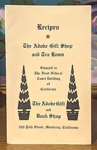
Adobe Gift Shop and Tea Room
Recipes - The Adobe Gift Shop and Tea Room. Situatied in the First Federal Court Building of California
Monterey California No Date. Stiff wraps. Near fine. 12mo. pp. 10 illustration of the First Federal Court Building inside the front and rear cover with historical text underneath the illustrations. unknown
Référence libraire : 10487
|
|
|
Adsorption Science And Technology: Proceedings Of The Second Pacific Basin Conference
1
World Scientific: Academic & Professional United States. Hardbound/Brand New. 9789810242633. Do Duong D. Academic & Professional hardcover
Référence libraire : STM-9789810242633
|
|
|
African Studies Association of Australasia and the Pacific. Conference (1999 : Perth, W. A.)
Re-Imagining Africa: New Critical Perspectives Horizons in Post-Colonial Studies
Brand: Nova Science Pub Inc 2002-01-01. UK ed. hardcover. New. 6.25x0.75x9.50. Buy with confidence. Excellent Customer Service & Return policy. Brand: Nova Science Pub Inc hardcover
Référence libraire : DADAX1590331001 ISBN : 1590331001 9781590331002

|
|
|
African Studies Association of Australasia and the Pacific. Conference (1999 : Perth, W. A.)
Re-Imagining Africa: New Critical Perspectives Horizons in Post-Colonial Studies
Brand: Nova Science Pub Inc 2002-01-01. UK ed. hardcover. Used: Good. 6.25x0.75x9.50. Buy with confidence. Excellent Customer Service & Return policy. Brand: Nova Science Pub Inc hardcover
Référence libraire : SONG1590331001 ISBN : 1590331001 9781590331002
|
|
|
AFWESPAC (Armed Forces Western Pacific)
Looking thru.AFWESPAC Printing Plant and Publications Depot
U S Army: AFWESPAC. VG wraps. late 1940s . booklet. paperback. 12mo . 72pp . Brochure of the Western Pacific Command likely its days in the postwar Philippines Lt Col Orson Powers commanding. Scarce. No date but likely late 40s early '50s Quonset hut era! Names and pics of all personnel at the time. . AFWESPAC paperback
Référence libraire : MAIN024478I
|
|
|
Agassiz, A.
The Islands and Coral Reefs of Fiji.
1899 167 p., 120 pls & folded maps, paperbound (covers somewhat chipped). Unopened copy. We added: Murray, Alexander Agassiz: His Life and Scientific Work (20 p.). Published in: Bulletin of the Museum of Comparative Zoölogy.
Référence libraire : HM03884
|
|
|
Agabin, PACIFICO
Mestizo: The Story of the Philippine Legal System Second Edition
NEW. unknown
Référence libraire : BIB-NOV-14-2025-622866 ISBN : 3659921629 9783659921629
|
|
|
Agassiz, G. R. (editor)
LETTERS AND RECOLLECTIONS OF ALEXANDER AGASSIZ WITH A SKETCH OF HIS LIFE AND WORK
Brown buckram boards with gilt lettering and minor rubbing to extremities. Numerous b&w illustrations from photographs and a photographure frontispiece. Large map in front pocket; 8vo; 454 pages
|
|
|
Agents of the Southern Pacific Company, Paul Shoup
California South of Tahachapi
Southern Pacific Company. 1900. First edition. . Wraps. Very good. light shefwear yellow covers no date but obviously old there is a census table and it only has information to 1900. Southern Pacific Company paperback
Référence libraire : Alibris.0085156
|
|
|
Aguilera, Carolina Garcia
Luck of the Draw: A Novel
N.Y.: Rayo 2003. First Edition so stated June 2003 with complete number line beginning with 1. Fine in fine dust jacket not price clipped with protective mylar cover. Publishers informational sheet laid in with a copy of NYT article on Aguilera. "Garcia-Aguilera. sends her Miami heroine off on a wild Las Vegas adventure in her latest an engaging thriller/mystery. Esmeralda Navarro a married 30ish interior designer is called to a family meeting by her mother who announces her plans to try to recover the casino she and her husband owned and ran in Havana before Castro took over Cuba. But the plan has to wait until the family can find Esmeralda's free-spirited sister Diamond who doesn't seem to be at her Las Vegas newspaper office or her apartment. Esmeralda temporarily ditches her family and her troubled marriage to go to Las Vegas to find her missing sister. Fearing the worst she arrives in Sin City with no plan but fortunately her limo driver the attractive middle-aged Dennis O'Shea turns out to be a retired NYPD homicide detective who helps her engineer a private investigation. After plenty of twists and turns the clues point to a new casino called the Star where Diamond took a job as a waitress before her disappearance.Esmeralda's adventure is as skillfully written and plotted as Garcia-Aguilera's successful Lupe Solano mystery series and Esmeralda is a feisty entertaining narrator." -- Publishers Weekly. 1st Edition. Hardcover. Fine/Fine. Book. Rayo
Référence libraire : 019749 ISBN : 0060536330 9780060536336

|
|
|
Air Force U. S. Pacific Fleet Squadron 2
Air Force United States Pacific Fleet Photographer Interpretations Squadron Two Interpron Two the Record of Our Squadron How We
New York: Squadron Press. Good with no dust jacket. 1945. Paperback. N. A. S Barber's Point T. H Jan.1911 -April 1911. Enwetor Marshall Islands May 1911 - Oct. 1911 Guam Marimas Islands Oct.1911-191; Spine defective . Squadron Press paperback
Référence libraire : 190476
|
|
|
AIR MAIL ACROSS THE PACIFIC SAN FRANCISCO TO HONG KONG.
AIR MAIL ACROSS THE PACIFIC SAN FRANCISCO TO HONG KONG.
San Francisco 1937 G.P.O. A large poster on stiff board 33 x 48 cm. white with black ink b.w. photo and aircraft English & mostly Chinese text time tables for departing air craft and schedule. OBSCURE ITEM LIMITED EDITION OF 500 This lovely period poster was printed September 30 1937 in a LIMITED EDITION OF 500 only copies per the colophon at the bottom of the poster. CONDITION: The poster is very clean and obscure. There are 2 very tiny mended closed tears in the right and lower margin else this is a very clean nice copy of a rare item. There is almost no surface soil and a small bump to lower right corner again none of this invades the text at all and can be matted out in a frame. The "CHINA CLIPPER" an early Pan-Am aircraft is shown flying over the city of San Francisco just above Fisherman's Wharf and other piers and North Beach Russian Hill the tower and downtown in the background. The text informs the Chinese community about the new air mail service drop off locations times of pickup and the like. Nicely executed. QUITE SCARCE . unknown
Référence libraire : 28030401

|
|
|
Ajami, Newsha, Gleick, Peter H., Christian-Smith, Juliet, Pacific Institute, Cooley, Heather
The World's Water Volume 8 : The Biennial Report on Freshwater Resources
Island Press. Used - Good. Used book that is in clean average condition without any missing pages. Island Press unknown
Référence libraire : 53522138-75 ISBN : 1610914821 9781610914826

|
|
|
Ajami, Newsha, Gleick, Peter H., Christian-Smith, Juliet, Pacific Institute, Cooley, Heather
The World's Water Volume 8 : The Biennial Report on Freshwater Resources
Island Press. Used - Good. Former library book; may include library markings. Used book that is in clean average condition without any missing pages. Island Press unknown
Référence libraire : 16562388-6 ISBN : 1610914821 9781610914826
|
|
|
Ajami, Newsha, Gleick, Peter H., Christian-Smith, Juliet, Pacific Institute, Cooley, Heather
The World's Water Volume 8 : The Biennial Report on Freshwater Resources
Island Press. Used - Very Good. Ships from the UK. Former library book; may include library markings. Used book that is in excellent condition. May show signs of wear or have minor defects. Island Press unknown
Référence libraire : 17411288-75 ISBN : 1610914821 9781610914826
|
|
|
 Recevoir par e-mail
 Télécharger en PDF
 Flux RSS


