|
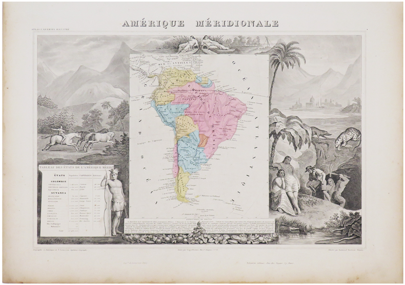
LEVASSEUR (Victor).
Amérique méridionale.
Paris, [1861]. 315 x 425 mm.
書籍販売業者の参照番号
: LBW-6938
|
|
|
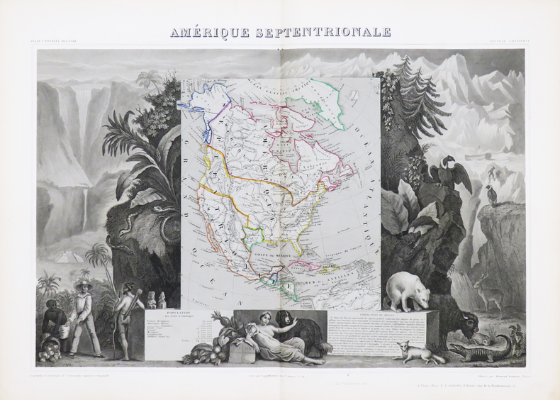
LEVASSEUR (Victor).
Amérique septentrionale.
Paris, [circa 1850]. 310 x 439 mm.
書籍販売業者の参照番号
: LBW-4867
|
|
|
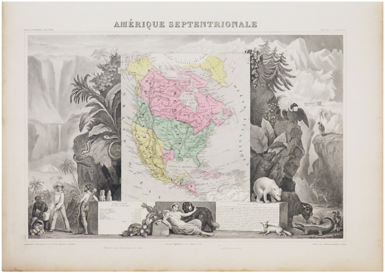
LEVASSEUR (Victor).
Amérique septentrionale.
Paris, [1861]. 307 x 434 mm.
書籍販売業者の参照番号
: LBW-6933
|
|
|
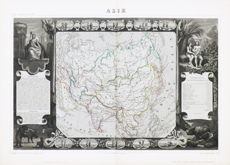
LEVASSEUR (Victor).
Asie.
Paris, [circa 1850]. 320 x 438 mm.
書籍販売業者の参照番号
: LBW-4864
|
|
|
LEVASSEUR (Victor).
Asie.
Paris, [1861]. 320 x 436 mm.
書籍販売業者の参照番号
: LBW-6951

|
|
|
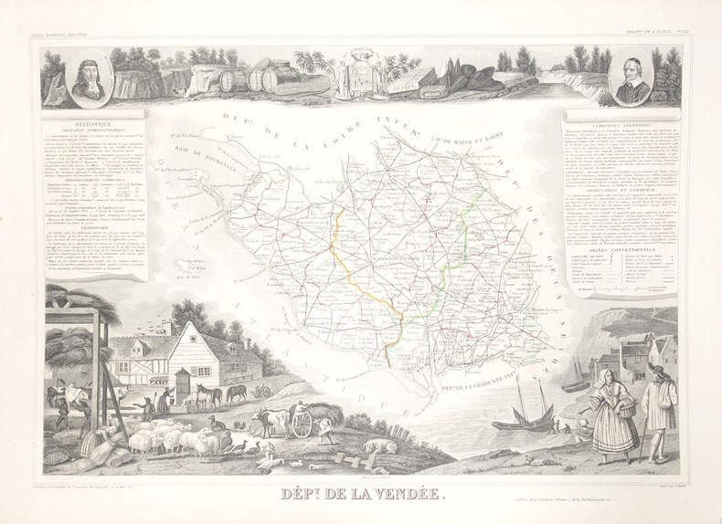
LEVASSEUR (Victor).
Dépt. de la Vendée.
Paris, 1849. 298 x 423 mm.
書籍販売業者の参照番号
: LBW-2404
|
|
|
LEVASSEUR (Victor).
Dépt. des Côtes du Nord.
Paris, 1849. 295 x 412 mm.
書籍販売業者の参照番号
: LBW-2407

|
|
|
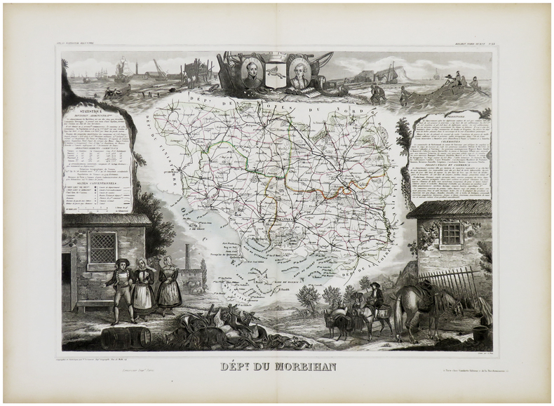
LEVASSEUR (Victor).
Dépt. du Morbihan.
Paris, [1849]. 295 x 404 mm.
書籍販売業者の参照番号
: LBW-2406
|
|
|
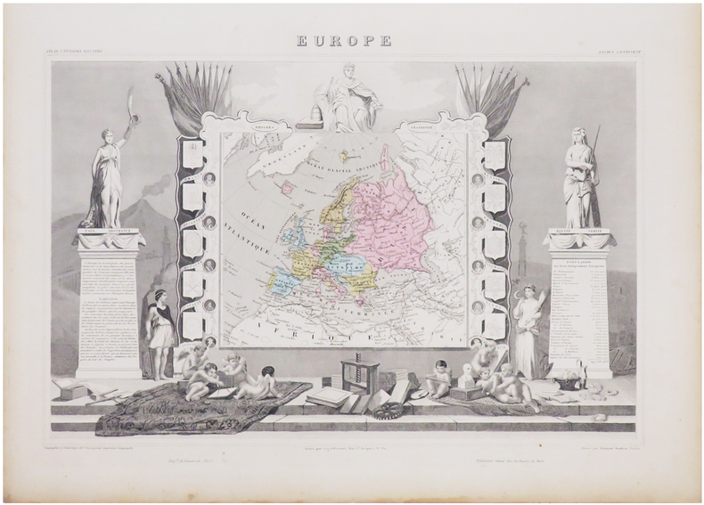
LEVASSEUR (Victor).
Europe.
Paris, [circa 1850]. 320 x 441 mm.
書籍販売業者の参照番号
: LBW-4862

|
|
|
LEVASSEUR (Victor).
Europe.
Paris, [1861]. 320 x 440 mm.
書籍販売業者の参照番号
: LBW-6934
|
|
|
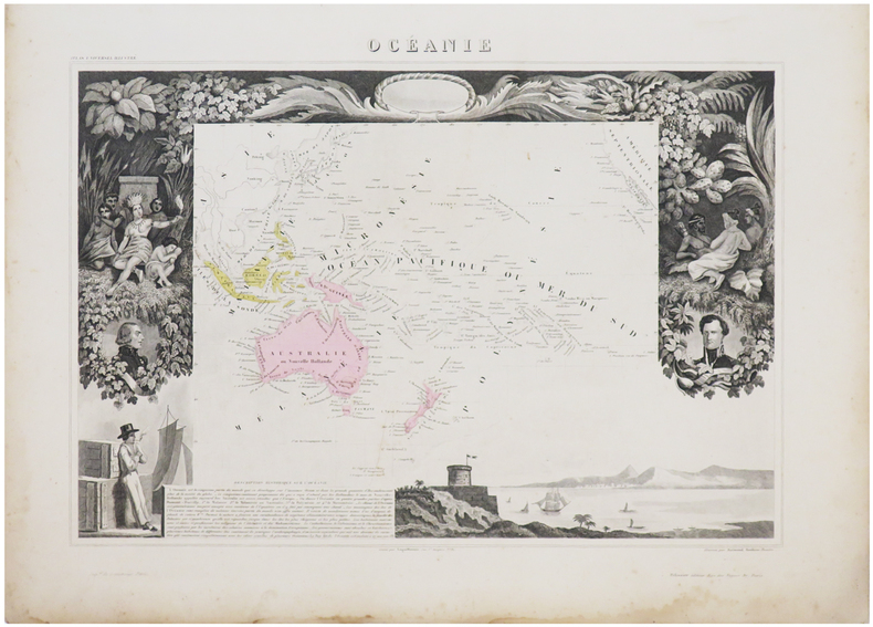
LEVASSEUR (Victor).
Océanie.
Paris, [circa 1850]. 315 x 423 mm.
書籍販売業者の参照番号
: LBW-4865

|
|
|
LEVASSEUR (Victor).
Océanie.
Paris, [1861]. 315 x 422 mm.
書籍販売業者の参照番号
: LBW-6953
|
|
|
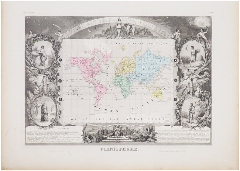
LEVASSEUR (Victor).
Planisphère.
Paris, [1861]. 300 x 413 mm.
書籍販売業者の参照番号
: LBW-6939
|
|
|
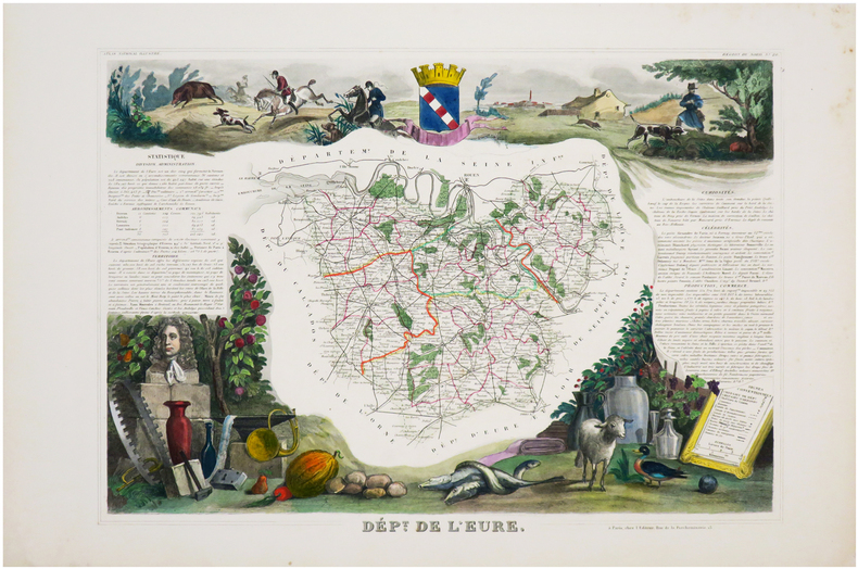
LEVASSEUR (Victor);
[EURE] Dép.t de l'Eure.
Paris, [1849]. 295 x 422 mm.
書籍販売業者の参照番号
: LBW-6963
|
|
|
LEVASSEUR V.
Carte DEPARTEMENT de la LOZERE
Carte gravée par LAGUILLERMIE et RAINAUD ,extraite de l'Atlas National illustré des 86 départements et des possessions de la France' divisé par arrondissements, cantons et communes avec le tracé de toutes les routes, chemins de fer et canaux. Dressé d'après les travaux du cadastre du dépôt de la guerre et des ponts et chaussées par V. LEVASSEUR ingénieur
書籍販売業者の参照番号
: 2764
|
|
|
Levasseur, Victor
[Karte des] Dépt. Du Bas Rhin. Région du Nord-Est N° 66. Stahlstich von Laguillermie u. Rainaud mit flächenkolorierter Kartographie.
Paris, Pelissier, [ca. 1865]. Darstellung 30 x 44 cm, Blattmaß 51 x 35 cm. Unter Feinkartonpassepartout.
書籍販売業者の参照番号
: 88392

|
|
|
Levasseur, Victor
[Karte des] Dépt. Du Haut Rhin. Région du Nord-Est N° 67. Stahlstich von Burty mit flächenkolorierter Kartographie.
Paris, Pelissier, [ca. 1865]. Darstellung 30 x 44 cm, Blattmaß 51 x 35 cm. Unter Feinkartonpassepartout.
書籍販売業者の参照番号
: 88386

|
|
|
LEVESQUE [Pierre-Charles]:
Histoire de Russie, tirée des chroniques originales, de pieces authentiques, & des meilleurs historiens de la nation [avec] Histoire des différents peuples soumis à la domination des Russes ou Suite de l'histoire de Russie.
A Paris, chez Debure l'aîné, 1782. 7 volumes in-12 de [2]-XLVIII-442; [4]-516; 570; [4]-548; [4]-565-[3]; [4]-LX;537 et [4]VII-497-[3] pages, plein veau moucheté, dos lisses ornés de filets, fleurons, encadrements et titre dorés, étiquettes de titre bordeaux et de tomaison vertes, triple filet doré encadrant les plats, simple sur les coupes, tranches rouges. Quelques épidermures, la coiffe sup. manque au second volume et souffre d'un petit manque au premier, rares rousseurs, 2 cahiers très légèrement déboîtés au volume 3, accroc au mors inférieur du vol. 7.
書籍販売業者の参照番号
: 9809

|
|
|
Levi Peter
Atlas of The Greek World
New York: Facts on File 1980 This book introduces the reader to the ancient Greeks their spiritual and mental world as well as the physical world their history and travels as well as their arts and sciences. It is impossible to understand Greek history or art without a strong sense of the prehistory the landscape the climate the geography and the conditions of life. Atlas of the Greek World sets the scene for this study and then through the use of an authoritative text maps and illustrations takes the reader through the history stopping to view 26 ancient sites and to comment on the achievements of this remarkable civilisation. Covers topics such as : The land in context. The geography of ancient Greece; The study of ancient Greece; The age of bronze. The palace civilizations of Crete and Mycenae; Mycenaean survivals; The Homeric world; The age of tyranny. The 8th-century renaissance; Archaic religious practice; The birth of city-states; The growth of literature; The age of Perikles. Athenian society in the 5th century; The Persian and Peloponnesian Wars; The classical revolution; The age of Alexander. New patterns in literature and religion; The rise of Macedon; The Alexandrian expansion; The Roman conquest; The fate of Hellenism. The classical impact of Hellenism; Post-classical revivals; Language : the principal inheritance.239p. illus bibliography index maps on endpapers. 1st US Edition. Hardcover. As New/As New. Facts on File hardcover
書籍販売業者の参照番号
: 30499 ISBN : 0871964481 9780871964489

|
|
|
Levin Alex; Sir Matin Gilbert Maps
Under the Yellow & Red Stars
Second Story Press. Fine. 2009. First Edition; First Printing. Softcover. 9781897470077 . Stiff crisp unmarked book about new. ; Azrieli Series of Holocaust Survivor Memoirs; 208 pages . Second Story Press paperback
書籍販売業者の参照番号
: 49799 ISBN : 189747007x 9781897470077

|
|
|
Lewis Cynthia C. and Thomas J. Lewis \edited by Lorretta Palagi\ \maps by Newell Cartographics\ \cover design by Elizabeth Wats
BEST HIKES WITH CHILDREN IN CONNECTICUT MASSACHUSETTS & RHODE ISLAND
Seattle: The Mountaineers . Seattle: Fine. 1994. Later Printing. 0898862655 . Later 6th printing thus. 256 pages profusely illustrated with photographs and maps. Fine copy. . bx 319 . Fine. Paperback. n Later Printing. Printing Unknown. 1994. The Mountaineers paperback
書籍販売業者の参照番号
: 44346 ISBN : 0898862655 9780898862652

|
|
|
Lewis Harrison; Lewis Hilda B. Illustrations by; Perrett John line drawings and maps by
A Guide to the Remote Paths and Lanes of Ancient Malta
Bucks England: Colin Smythe 1974. Paperback. Very Good. 1974 edition not stated. Softcover in Very Good condition with the light shelf wear and light soil to the edges of the text block corners bumped else clean and tight. Five fold out maps to the rear pocket are in Fine condition. Pages: 65. Colin Smythe paperback
書籍販売業者の参照番号
: d00299
|
|
|
LEWIS John Frederick
LEWIS'S ILLUSTRATIONS OF CONSTANTINOPLE Made During a Residence in That City in the Years 1835-6
London: T. McLean D.& P. Colnaghi and John F. Lewis 1838. 1838. Complete with all Lithographic plates as called for; tinted frontispiece tinted title-vignette further 27 tinted views on 25 leaves all by Lewis after Coke Smyth. A very clean bright copy. Finely bound in modern brown morocco to style with gilt lettering to the spine and gilt bands to the top and bottom of the spine. Contents clean and tight new light brown endpapers in keeping with the new binding two blank leaves to the front and rear all pages have been professionally cleaned and restored by a paper conservator minimal and unobtrusive water staining remains to some pages and plates mostly confined to the margins and blank areas most plates unaffected new archival paper guards to all plates no inscriptions. A fine complete copy beautifully rebound. References -. Abbey Travel II 394; Atabey 722; Blackmer 1015; Contominas 413; RIBA 1886. First Edition. Hardcover. Near Fine/No Dust Jacket. Illus. by John F. Lewis. Folio approx. 55 x 36.5cm. T. McLean, D.& P. Colnaghi and John F. Lewis [1838]. Hardcover
書籍販売業者の参照番号
: 021038

|
|
|
Lewis Samuel; maps drawn by R. Creighton
Lewis' Topographical Dictionary of England. Atlas volume only with 42 of 45 maps
London: S. Lewis. Fair with no dust jacket. 1840s. Hardcover. Atlas volume only with 42 maps only of 45. Includes 12 folding maps. The three missing maps are the map of "England & Wales" the London map and the Yorkshire map. Hand-coloured maps of English counties also includes maps of Jersey Guernsey and the Isle of Man. Page dimensions: 284 x 220mm. Lacking the Index leaf free endpapers and any preliminary leaves. Original cloth boards worn and stained with tears and chips to spine cloth. Text block detached from boards. Binding poor. Maps in good condition. A 1 1/2" tear along the fold of the Cumberland map. No tears or chips to other maps. Some foxing to maps. Owner's signature and moderate staining to the map of Bedfordshire. ; 4to . S. Lewis hardcover
書籍販売業者の参照番号
: 11527

|
|
|
LEÓN TELLO, Pilar.
Catálogo de Mapas, Planos y Dibujos en la Sección de Estado del Archivo Histórico Nacional.
Madrid, Ministerio de Educación, 1969. 4to. mayor; 205 pp., 2 hs. y 19 láminas aparte. Cubiertas originales.

|
|
|
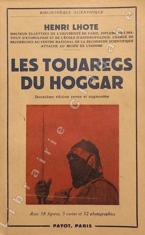
Lhote (Henri) :
Les Touaregs du Hoggar (Ahaggar). Avec 58 figures, 5 cartes et 32 photographies. 2e édition, revue et augmentée.
Paris, Payot, 1955 ; in-8 (228 mm), broché ; 567 pp., [10] pp. de catalogue, XVI planches de 32 photographies, couverture beige illustrée, tirée en rouge et bleu foncé.
書籍販売業者の参照番号
: 20350
|
|
|
LHOTE Henri:
Dans les campements touaregs.
Paris, Amiot-Dumont, 1952. In-8 broché de 268-[4] pages, couverture imprimée en bleu et noir sous jaquette photographique. Bande de lancement ("Un chef-d'oeuvre - Prix voyages et aventures") conservée.
書籍販売業者の参照番号
: 10455

|
|
|
LHOTE Jean-Marie
Bizarre N° 43-44. Shakespeare dans les tarots et autres lieux ou tentative de divination cohérente, à la fois théorique et pratique au travers du "Songe d'une nuit d'été".
Paris: J.-J. Pauvert, 1967 in-4, 100 pages, illustrations. Broché, couv. défraichie et coins cornés.
書籍販売業者の参照番号
: 1106327
|
|
|
LHOTE Jean-Marie
kleber et Marie-Louise
Hachette. 1979. In-4. Relié toilé. Bon état, Couv. convenable, Dos satisfaisant, Intérieur frais. 90p, illustré de reproduction de cartes postales dans le texte, relié toilé noir.. Avec Jaquette. . . Classification Dewey : 741.68-Illustrations des cartes postales
書籍販売業者の参照番号
: RO20017149
|
|
|
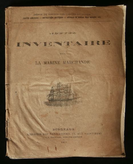
Librairie des Navigateurs, 17 rue Saint-Rémi à BORDEAUX, Dépot de toutes les cartes du globe
NOUVEL INVENTAIRE POUR LA MARINE MARCHANDE ( catalogue ) .
Bordeaux, Librairie des Navigateurs, 1864, cahier format 250x190mm, couverture parcheminée, 28 pages, exemplaire un peu défraîchi quelques traces de pliures, petit accroc en haut des trois derniers feuillets, sinon l'état est correct.
書籍販売業者の参照番号
: 10873
|
|
|
LIBRAIRIE LE BAIL
PORTRAITS DE LA FRANCE ET DU MONDE . Cartes et vues de villes du XVIè au XIXè siècle
LIBAIRIE LE BAIL . 2010 . 117 pages . Broché
書籍販売業者の参照番号
: 8905
|
|
|
Library of Congress. Division of Maps and Charts Phillips Philip Lee Phillips Philip Lee
A list of maps of America in the Library of Congress 1901 Leather Bound
2019. Leather Bound. New. Leather Binding on Spine and Corners with Golden Leaf Printing on round Spine. Reprinted in 2019 with the help of original edition published long back 1901. This book is printed in black & white sewing binding for longer life Printed on high quality Paper re-sized as per Current standards professionally processed without changing its contents. As these are old books we processed each page manually and make them readable but in some cases some pages which are blur or missing or black spots. If it is multi volume set then it is only single volume if you wish to order a specific or all the volumes you may contact us. We expect that you will understand our compulsion in these books. We found this book important for the readers who want to know more about our old treasure so we brought it back to the shelves. Hope you will like it and give your comments and suggestions. Lang: - eng Pages 1176. EXTRA 10 DAYS APART FROM THE NORMAL SHIPPING PERIOD WILL BE REQUIRED FOR LEATHER BOUND BOOKS. FOLIO EDITION IS ALSO AVAILABLE. hardcover
書籍販売業者の参照番号
: LB1111005375167
|
|
|
Library of Congress. Division of Maps and Charts Phillips Philip Lee Phillips Philip Lee
A list of maps of America in the Library of Congress 1901 Leather Bound
2019. Leather Bound. New. Leather Binding on Spine and Corners with Golden Leaf Printing on round Spine. Reprinted in 2019 with the help of original edition published long back 1901. This book is printed in black & white sewing binding for longer life Printed on high quality Paper re-sized as per Current standards professionally processed without changing its contents. As these are old books we processed each page manually and make them readable but in some cases some pages which are blur or missing or black spots. If it is multi volume set then it is only single volume if you wish to order a specific or all the volumes you may contact us. We expect that you will understand our compulsion in these books. We found this book important for the readers who want to know more about our old treasure so we brought it back to the shelves. Hope you will like it and give your comments and suggestions. Lang: - eng Pages 1228. EXTRA 10 DAYS APART FROM THE NORMAL SHIPPING PERIOD WILL BE REQUIRED FOR LEATHER BOUND BOOKS. FOLIO EDITION IS ALSO AVAILABLE. hardcover
書籍販売業者の参照番号
: LB1111005375170
|
|
|
Library of Congress. Division of Maps and Charts Phillips Philip Lee Phillips Philip Lee
A list of maps of America in the Library of Congress 1901 Hardcover
2020. Hardcover. New. Lang: - eng Pages 1176. Reprinted in 2020 with the help of original edition published long back 1901. This book is Printed in black & white Hardcover sewing binding for longer life with Matt laminated multi-Colour Dust Cover Printed on high quality Paper re-sized as per Current standards professionally processed without changing its contents. As these are old books we processed each page manually and make them readable but in some cases some pages which are blur or missing or black spots. If it is multi volume set then it is only single volume if you wish to order a specific or all the volumes you may contact us. We expect that you will understand our compulsion in these books. We found this book important for the readers who want to know more about our old treasure so we brought it back to the shelves. Any type of Customisation is possible with extra charges. Hope you will like it and give your comments and suggestions. hardcover
書籍販売業者の参照番号
: 1111005375167
|
|
|
Library of Congress. Division of Maps and Charts Phillips Philip Lee Phillips Philip Lee
A list of maps of America in the Library of Congress 1901
2020. Paperback. New. Lang: - eng Pages 1176. Reprinted in 2020 with the help of original edition published long back 1901. This book is Printed in black & white sewing binding for longer life with Matt laminated multi-Colour Soft Cover HARDCOVER EDITION IS ALSO AVAILABLE Printed on high quality Paper re-sized as per Current standards professionally processed without changing its contents. As these are old books we processed each page manually and make them readable but in some cases some pages which are blur or missing or black spots. If it is multi volume set then it is only single volume if you wish to order a specific or all the volumes you may contact us. We expect that you will understand our compulsion in these books. We found this book important for the readers who want to know more about our old treasure so we brought it back to the shelves. Any type of Customisation is possible with extra charges. Hope you will like it and give your comments and suggestions. paperback
書籍販売業者の参照番号
: PB1111005375167
|
|
|
Library of Congress. Division of Maps and Charts Phillips Philip Lee Phillips Philip Lee
A list of maps of America in the Library of Congress 1901
2020. Paperback. New. Lang: - eng Pages 1228. Reprinted in 2020 with the help of original edition published long back 1901. This book is Printed in black & white sewing binding for longer life with Matt laminated multi-Colour Soft Cover HARDCOVER EDITION IS ALSO AVAILABLE Printed on high quality Paper re-sized as per Current standards professionally processed without changing its contents. As these are old books we processed each page manually and make them readable but in some cases some pages which are blur or missing or black spots. If it is multi volume set then it is only single volume if you wish to order a specific or all the volumes you may contact us. We expect that you will understand our compulsion in these books. We found this book important for the readers who want to know more about our old treasure so we brought it back to the shelves. Any type of Customisation is possible with extra charges. Hope you will like it and give your comments and suggestions. paperback
書籍販売業者の参照番号
: PB1111005375170
|
|
|
Library of Congress. Division of Maps and Charts Phillips Philip Lee Phillips Philip Lee
A list of maps of America in the Library of Congress 1901 Hardcover
2020. Hardcover. New. Lang: - eng Pages 1228. Reprinted in 2020 with the help of original edition published long back 1901. This book is Printed in black & white Hardcover sewing binding for longer life with Matt laminated multi-Colour Dust Cover Printed on high quality Paper re-sized as per Current standards professionally processed without changing its contents. As these are old books we processed each page manually and make them readable but in some cases some pages which are blur or missing or black spots. If it is multi volume set then it is only single volume if you wish to order a specific or all the volumes you may contact us. We expect that you will understand our compulsion in these books. We found this book important for the readers who want to know more about our old treasure so we brought it back to the shelves. Any type of Customisation is possible with extra charges. Hope you will like it and give your comments and suggestions. hardcover
書籍販売業者の参照番号
: 1111005375170
|
|
|
Liechtenstern, Joseph Marx von.
Allgemeine Charte des Kaiserthums Oesterreich, nebst einem grossen Theile Deutschlands, der Schweiz, Italiens, der Türkey, Russlands und Preussens. Wien, Joseph Riedl, 1816.
1410 x 1755 mm. Grenzkolorierte Kupferstichkarte in 9 Blättern, Maßstab ca. 1:900.000. Jedes Blatt in 12 Segmenten auf Leinen aufgezogen. Blatt 9 mit dem Plan "Wien mit seinen Umgebungen". Gefaltet in zeitgenöss. marmoriertem Umschlag und Originalschuber des Verlags mit goldgepr. Rückenschildchen "Kaiserthum Oesterreich". Letzte Auflage dieser ausgezeichneten, erstmals 1809 erschienenen monumentalen Gesamtkarte der Habsburgermonarchie - der "bis dahin weitaus größte[n] gedruckte[n] Karte der Österreichischen Monarchie" (Austria Picta). In dieser Auflage neu dargestellt sind die "im Münchner Vertrag festgelegten Grenzen zwischen Bayern und Österreich" (Dörflinger, S. 607). In ihrem grundlegenden Umfang noch 1805 entworfen, wurde die Karte vom Pressburger Frieden am 26. Dezember 1805 und dann von einem langen Streit zwischen Kartograph und Verlag überholt, sodass die neun Blätter "jenen Raum dar[stellen], der bis Dezember 1805 zur Österreichischen Monarchie gehörte - also auch Tirol und Vorarlberg, Venetien und Dalmatien sowie die Vorlande, wobei sich diese Territorien noch zusätzlich durch ihre dichte Topographie von den angrenzenden nicht-österreichischen Gebieten optisch deutlich abheben [...] Von ganz ausgezeichneter Qualität [ist] der Stich von Joseph Stöber, der die stellenweise Überfüllung mit Einzelheiten weitgehend mildert. Den Großteil von Blatt 9 nimmt die Nebenkarte 'Wien mit seinen Umgebungen' (Maßstab ca. 1:90.000) ein, die das Gebiet zwischen Korneuburg und Vöslau/Ebreichsdorf bzw. zwischen Langenlebarn/Breitenfurt und Fischamend/Ebergassing - also vor allem den südlichen und südöstlichen Teil des Umlandes von Wien - abbildet" (ebda., S. 605f.). - Umschlag und Schuber gering berieben. Vereinzelt kleine Randläsuren an den einzelnen Segmenten. Insgesamt wohlerhalten. Dörflinger 603ff., KIC 31. Vgl. Austria Picta 34.4 (Aufl. von 1811).
|
|
|
Lieude de Sepmanville Francois Cyprien Antoine de France. Depot des cartes et plans de la marine. Pilote de l'isle de Saint
Détail particulier pour la carte de la Gonave ajoutée en 1788 au Pilot de l'isle de Saint-Domingue. 1788 Leather Bound
2019. Leather Bound. New. Leather Binding on Spine and Corners with Golden Leaf Printing on round Spine. Reprinted in 2019 with the help of original edition published long back 1788. This book is printed in black & white sewing binding for longer life Printed on high quality Paper re-sized as per Current standards professionally processed without changing its contents. As these are old books we processed each page manually and make them readable but in some cases some pages which are blur or missing or black spots. If it is multi volume set then it is only single volume if you wish to order a specific or all the volumes you may contact us. We expect that you will understand our compulsion in these books. We found this book important for the readers who want to know more about our old treasure so we brought it back to the shelves. Hope you will like it and give your comments and suggestions. Lang: - fre Pages 24. EXTRA 10 DAYS APART FROM THE NORMAL SHIPPING PERIOD WILL BE REQUIRED FOR LEATHER BOUND BOOKS. FOLIO EDITION IS ALSO AVAILABLE. hardcover
書籍販売業者の参照番号
: LB1111007286297
|
|
|
Lieude de Sepmanville Francois Cyprien Antoine de France. Depot des cartes et plans de la marine. Pilote de l'isle de Saint
D�tail particulier pour la carte de la Gonave ajout�e en 1788 au Pilot de l'isle de Saint-Domingue. 1788 Hardcover
2020. Hardcover. New. Lang: - fre Pages 24. Reprinted in 2020 with the help of original edition published long back 1788. This book is Printed in black & white Hardcover sewing binding for longer life with Matt laminated multi-Colour Dust Cover Printed on high quality Paper re-sized as per Current standards professionally processed without changing its contents. As these are old books we processed each page manually and make them readable but in some cases some pages which are blur or missing or black spots. If it is multi volume set then it is only single volume if you wish to order a specific or all the volumes you may contact us. We expect that you will understand our compulsion in these books. We found this book important for the readers who want to know more about our old treasure so we brought it back to the shelves. Any type of Customisation is possible with extra charges. Hope you will like it and give your comments and suggestions. hardcover
書籍販売業者の参照番号
: 1111007286297
|
|
|
Lieutenant-Colonel DELCROS - Capitaine POLLET - Colonel BEL
Historique des 7ème et 47ème bataillons de chasseurs alpins et 25ème demi-brigade
1953 Editions G Le Pan de Ligny - 1953 - In-8, broché, couverture illustrée en N&B - 256 p. - Quelques illustrations en N&B in-texte
書籍販売業者の参照番号
: 112594

|
|
|
Lieutenant-Colonel ROUSSET
La Guerre au jour le jour. 6 volumes : Vol 1: août 1914 - avril 1915 - Vol 2 : avril à décembre 1915 - Vol 3 : Janvier à septembre 1916 - Vol 4 : septembre 1916 à juin 1917 - Vol 5 : juin 1917 à mai 1918 - Vol 6 : juin 1918 au 28 juin 1919. Avec 480 photographies ou dessins, 52 cartes et plans : 50 portraits, 378 scènes de batailles et vues panoramiques. Ouvrage augmenté des récits officiels et des principaux faits de guerre
1920 A Paris, Société d'Editions et de Publications, Librairie Jules Taillandier - 1920 - 6 vol in-8, demi percaline rouge à coins. 647 + 653 + 653 + 674 + 589 + 587 pages. 480 photographies ou dessins, 52 cartes et plans : 50 portraits, 378 scènes de batailles et vues panoramiques. Ouvrage augmenté des récits officiels et des principaux faits de guerre
書籍販売業者の参照番号
: 81275
|
|
|
LILLE
Carte couleurs (de Londres ? Mons et d'Amiens ? Ipswich). Sans date.
Une feuille toil?e 68x51 cm.
|
|
|
LILLE
Plan de poche.
Broch?. 11 pages. Plan 75x56 cm.
|
|
|
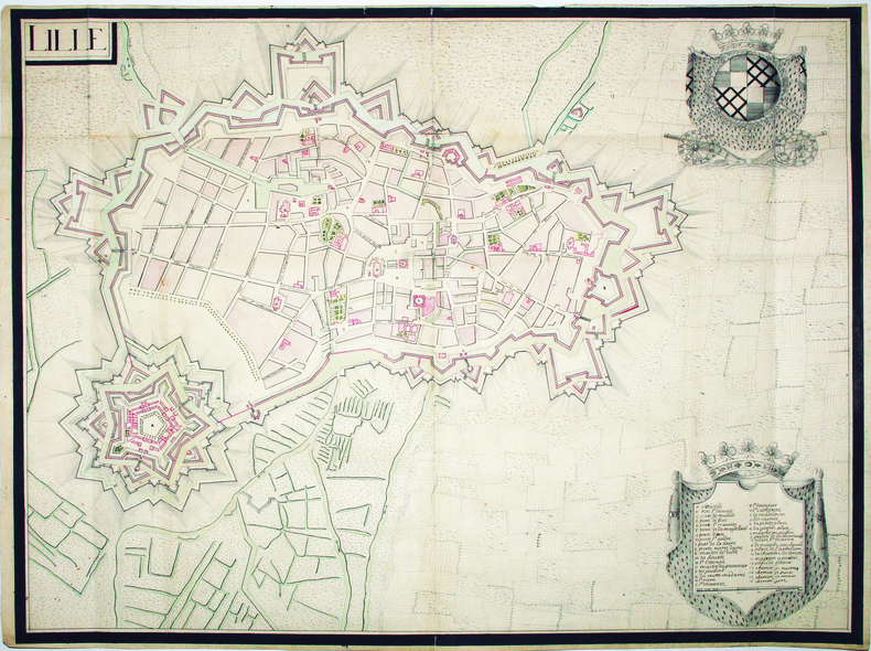
LILLE. MANUSCRIT.
Lille.
[circa 1710]. 500 x 667 mm.
書籍販売業者の参照番号
: LBW-4192
|
|
|
LILLE. MANUSCRIT.
Plan de la ville et citadelle de l’Isle.
[circa 1730]. 367 x 496 mm.
書籍販売業者の参照番号
: LBW-540

|
|
|
LILLE...
Nouveau plan de Lille et ses environs. Avec indication des rues, monuments, ?tablisements publics, curiosit?s. Sans date.
Broch?. 24 pages et 1 plan d?pliant hors texte
|
|
|
Limoges, Michel
Objectif : Chalon-sur-Saone
No marks or inscriptions. A lovely clean very tight copy with bright unmarked boards and no bumping to corners. Dust jacket not price clipped or marked or torn or creased with slight traces of handling. 96pp. culture, sport, art, architecture and much more about this area of the Saone in Western France. All text in French. Printed on fine quality paper. Very well illustrated with colour photographs.

|
|
|
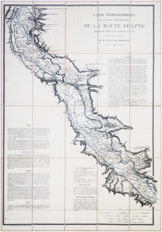
LINANT de BELLEFONDS (Louis-Maurice-Adolphe).
[HAUTE-ÉGYPTE] Carte hydrographique de la partie septentrionale de la Haute Égypte gravée au Dépôt de la Guerre en 1854 d'après les travaux de M.r Linant de Bellefonds. Revue et complétée en 1882.
1882. En 25 sections montées sur toile et repliées, formant une carte de 870 x 615 mm.
書籍販売業者の参照番号
: LBW-7838
|
|
|
Lindbergh Ann Morrow maps & foreword: Charles A. Lindbergh
LISTEN! THE WIND
New York NY: Harcourt Brace & Company. VG/G. 1938. First Edition. Cloth w/DJ. 8vo. 275 pp. DJ rubbed edges chipped and frayed DJ toning . Harcourt, Brace & Company hardcover
書籍販売業者の参照番号
: BOOKS276774
|
|
 検索結果のメールを受信する
 PDFファイルの検索結果をダウンロード
 RSSフィード


