|
Loftie, W. J.
LONDON. Historic Towns. Third Edition.
pp. x, 223, 24 [Publisher's catalogue] + folding map and two full page maps of London in various time periods. XLib stamp on title page. Engraved XLib bookplate. Text foxed. 8vo. Original full purple cloth binding. Faded gold lettered spine. Gilt decoration on front cover with embossed lettering in blind. Hardbound. Though XLib, this is still a nice copy. TRAVEL/1
|
|
|
LOGEROT (Auguste).
Nouveau plan routier de la ville de Paris ou Guide exact de cette capitale divisée en XII arrondissemens avec leurs mairies et en 48 quartiers. Par A. L.
Paris, Rosselin, 1831. En 32 sections montées sur toile et pliées, formant un plan de 0,75 x 1,02 m.
書籍販売業者の参照番号
: LBW-6853

|
|
|
LOGVINENKO (M.)
Vaucluse. Carte départementale dessinée par Mr Logvinenko.
1950 dans sa pochette. carte depliante, 530 x 710 mm., en couleurs. Avignon J. Y. Baud ca. 1950
書籍販売業者の参照番号
: 17160
|
|
|
Logan Clendening MD. with 25 illustrations & 2 Maps M. D.
A Handbook to Pickwick Papers whoever loves Charles Dickens immortal Story will find pleasure & instruction in this Guide in which is included a delightful memoir of a Pickwickian Journey a History Reflections on Reading it ETC
Alfred a. Knopf. HBDJ 1936 stated 1st Limited edition 2000 copies DJ minor rub wear & tiny chips & small mended Tears DJ Grey cloth Boards with red spine decorated Gold Gilt Minor cover Wear with tiny chips Ex tremities PC 156 pgs Interior Nice Tight Clean F. Alfred a. Knopf hardcover
書籍販売業者の参照番号
: 9976
|
|
|
Logiadou platonos Sosso
Crete : Archaeological and Historical Sites scenery Traditional Costumes
Athens: Mathioulakis Locally produced guidebook well illustrated. French wraps 31p. text 96 p. plates with descriptions in Greek English German and French No date c. 1980. Soft Cover. Very Good. Mathioulakis paperback
書籍販売業者の参照番号
: 15371
|
|
|
Logiadou-Platonos, Sosso
Crete : Archaeological and Historical Sites ,scenery, Traditional Costumes
Locally produced guidebook, well illustrated. French wraps 32p. text + 96 p. plates (with descriptions in Greek, English, German and French) No date (c. 1980?) Book
|
|
|
LOHEAC-AMMOUN Frank
TOUS LES JEUX DE CARTES, règles-techniques-conseils.
Ed. Solar, 1987, in8 cartonnage éditeur, 294 pages, nombreuses figures in-t, bon état.
書籍販売業者の参照番号
: 3276
|
|
|
LOISEAU J.
manuel des jeux(tome 1).
tome1:jeux d'observation ,d'attention et de maitrise du caractère.collection de la revue camping j.susse 1946 bon état 208 pages in 12 .
書籍販売業者の参照番号
: 797
|
|
|
LOIRE INFERIEURE
Carte routi?re d?partementale au 1/320 000?.
Une feuille 58x38 cm.
|
|
|
LOIRET
Atlas cantonal. Carte couleurs au 1/10 000e du canton de Chatillon sur Loire.
Une feuille. 55x75 cm. R?par?e.
|
|
|
LOIRET
Carte d?partementale au 1/200 000?. Sans date.
Une feuille repli?e. 75x56 cm.
|
|
|
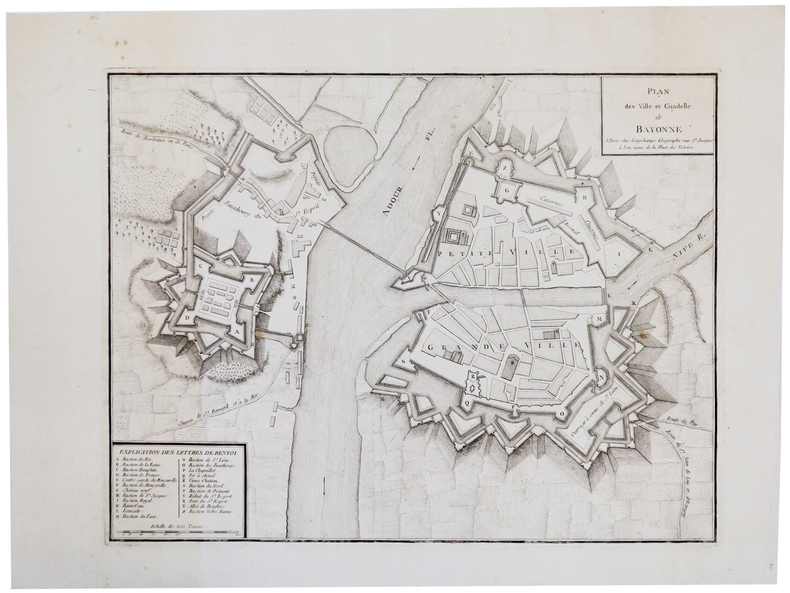
LONGCHAMPS (Sébastian G.).
[BAYONNE] Plan des ville et citadelle de Bayonne.
Paris, Longchamps, [circa 1750]. 355 x 457 mm.
書籍販売業者の参照番号
: LBW-5502
|
|
|
LONDON - CRUCHLEY, (GEORGE FREDERICK).
Cruchley's New Plan of London Shewing all the New and Intended Improvements to the Present Time. Published May 1st 1827 - A new Edition, Improved to 1st January 1833.
London, Cruchley map Seller, (1833). (42,5 x 60 cm.) Fine engraved and handcoloured map of London. Updated to 1833. The street- indexes engraved in the margins. The map is in fine condition, plain and not folded.
書籍販売業者の参照番号
: 49661
|
|
|
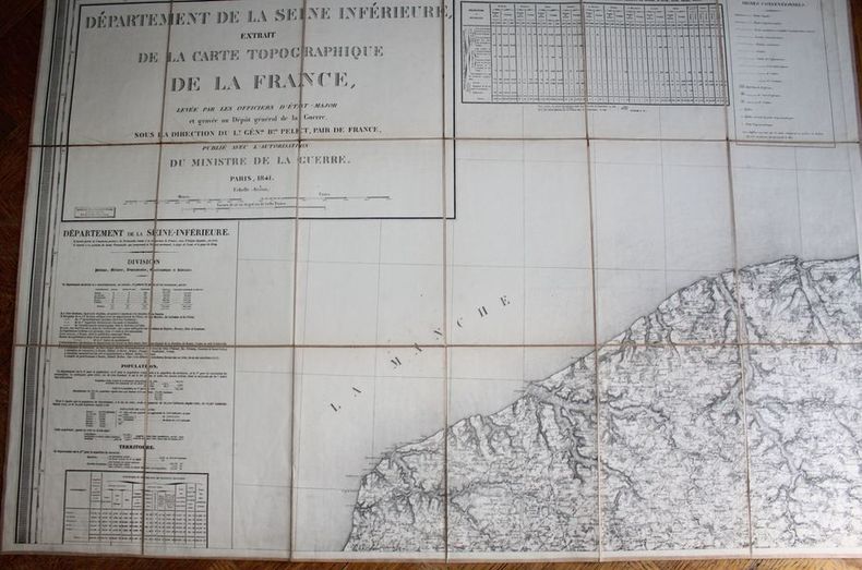
LONGUET.
Département de la Seine Inférieure - Extrait de la Carte topographique de la France, levée par les officiers d'Etat-Major et gravée au Dépôt général de la Guerre sous la direction du Lt. Général Baron Pelet, pair de France, publié avec l'autorisation du ministre de la Guerre.
Paris, Longuet, succ. de Simonneau, 1841. Ensemble complet de quatre grandes cartes (99 X 70 chacune) , échelle 1/80000e, en feuilles et contrecollées sur toile écrue (rousseurs à la toile). La première porte de grands cartouches : division, population, territoire; état indicatif du nombre et du tonnage des batiments entrés dans les ports du département (bureaux principaux des douanes, Le Havre, Rouen, Fécamp, Dieppe). Très bon état pour l'ensemble. Dans son étui de cartonnage en papier marbré, titre en long sur papier rouge. Usagé.
書籍販売業者の参照番号
: 20608
|
|
|
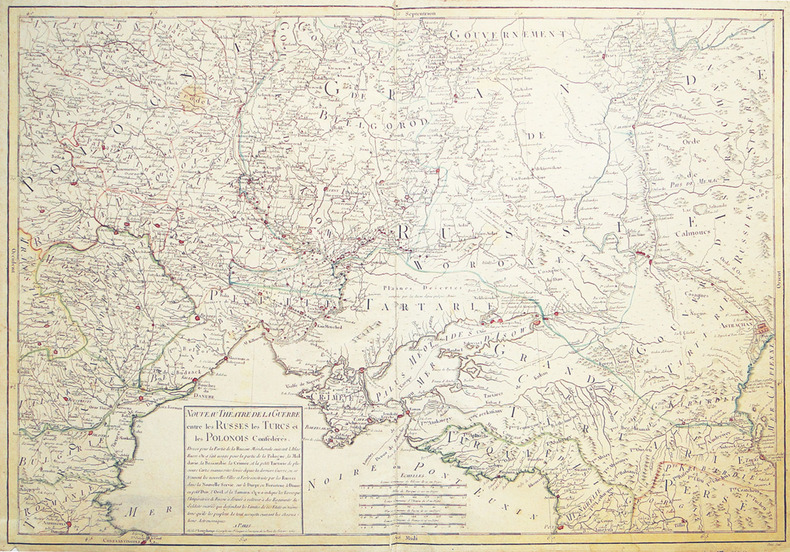
LONGCHAMPS (Sébastien).
Nouveau théâtre de la guerre entre les Russes les Turcs et les Polonois confédérés.
Paris, Sr. Longchamps, 1769. 522 x 760 mm.
書籍販売業者の参照番号
: LBW-2701
|
|
|
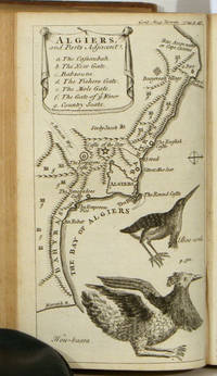
LONDON ALGIERS SOUTH AMERICA MAPS VIEWS Urban SylvanusDavid Henry Editor. Jefferys Thomas cartographer et al.
Gentleman's Magazine and Historical Chronicle January to December 1749.
London.: D. Henry and R. Cave at St. John's Gate. Volume XIX. 1749. Bound volume in leather binding leather spine intact but abraded with loss at head and tail covers detached corners bumped; 8.75 x 5.25 inches; title page and preface; 599 pp including Supplement plus index listing Essays Poetry Names etc. included in the 12 issues. Bookplate on verso of front cover of A. O. Sillifant. Reports and maps relating to South America; Heraldic Plates of Scotch and Irish Peers etc. Plates and maps are present according to the Directions for placing the Plates EXCEPT FOR: plate IV The Lion; plate IX Fireworks; plate XIII The Laocoon; Plate XIV Plan of St Petersburgh; Plate XVIII A View of the Nave of St Peter's In Rome; plate XIX The Front Prospect of Blenheim House. A chief feature of the volume is the several engraved copper-plate maps. They are listed with sheet size as follows: 1 A Plan of London and Westminster 8 x 10.25 inches; abraded top left and bottom left margins; 2 South America Drawn from the Best Maps by T. Jefferys Geographer to His Royal Highness the Prince of Wales 12 x 9.5 inches; abraded top left and bottom right margins short tear at right margin circular spotting top left; 3 Algiers and Parts Adjacent 8.25 x 4.75 very good condition. The volume also includes a number of intriguing engravings. Chief among these is A View and Plan of Noah's Ark 12 x 9.75 with 2.5 inch closed tear at right margin. Other engravings include The North East View of the Nave of the Cathedral Church of St. Paul 8.25 x 5 inches; A Perspective View of Radcliffe Library 8.25 x 5 inches; A View of Covent Garden from the Church Portico 8.25 x 5 inches; Habits of the Spaniards in Peru 8.25 x 5 inches; The Shield of Achilles as Described by Homer 8.125 x 10.25 inches; a dozen plates of the heraldic crests of Scots and Irish Peers and numerous other fascinating engravings. . D. Henry and R. Cave at St. John's Gate. hardcover
書籍販売業者の参照番号
: 50819
|
|
|
LONDON - CRUCHLEY, (GEORGE FREDERICK).
Cruchley's New Plan of London Shewing all the New and Intended Improvements to the Present Time. Published May 1st 1827 - A new Edition, Improved to 1st January 1833.
London, Cruchley map Seller, (1833). (42,5 x 60 cm.) Fine engraved and handcoloured map of London. Updated to 1833. The street- indexes engraved in the margins. The map is in fine condition, plain and not folded.
|
|
|
LONDON.
Index to the Streets and Places contained in the Map of London published in the Post Office Directory for 1918. BRIGHT, CLEAN COPY IN PUBLISHER'S WALLET WITH RETAINER
8vo., Index of 68pp facing large folding coloured map mounted on linen, measuring 30 x 44 ins (approx. 76 x 112 cms) folding in 36 panels to 7.5 x 5.5 ins (19 x 14 cms); the whole housed in publisher's red cloth wallet, upper board framed in blind and lettered in gilt with black retaining band (stretched through use and somewhat loose), a very good, bright, clean copty The map (scale: 4 inches to 1 mile) extends to Hampstead and Hackney in the north, Bromley and Greenwich in the east, Kennington and Walham Green in the south, and Brondesbury and Kensal Green in the west. EXTREMELY SCARCE IN THIS CONDITION.

|
|
|
Long E. B. with Barbara Long; Foreword by Bruce Catton; Maps by Barbara Long
The Civil War Day By Day: An Almanac 1861-1865
Doubleday & Company NY 1971. 1st edition. Hardcover. Fine/Fine. "In all the vast collection of books on the American Civil War there is no book like this one. It has been needed for a long time both by the student and by the man who simply likes to read about the Civil War but until now no one had the dedication or the encyclopedic knowledge to produce it. Here it is at last - an almanac or day-by-day recital down to the close conflict written by Professor E. B. Long of the University of Wyoming." Pub Info 1ST EDITION. Doubleday & Company, NY hardcover
書籍販売業者の参照番号
: 1016HILT-4068

|
|
|
Long, Peter
Hidden Inns of East Anglia
Second edition. No inscriptions or marks. Minor crease to rear cover and last four pages, none to front or to spine. A lovely clean very tight copy with bright unmarked boards and no bumping to corners. 228pp. A fully illustrated guide to the more secluded traditional Inns and Pubs in Suffolk, Norfolk, Essex and Cambridgeshire.

|
|
|
Loon Joannes van Pugsley William H. William Howard donor WH. Pugsley Collection of Early Canadian Maps W. H.
Pas-caerte van Terra Nova Nova Francia Nieuw Engeland en de gro: te Rivier van Canada 1666 Leather Bound
2019. Leather Bound. New. Leather Binding on Spine and Corners with Golden Leaf Printing on round Spine extra customization on request like complete leather Golden Screen printing in Front Color Leather Colored book etc. Reprinted in 2019 with the help of original edition published long back 1666. This book is printed in black & white sewing binding for longer life Printed on high quality Paper re-sized as per Current standards professionally processed without changing its contents. As these are old books we processed each page manually and make them readable but in some cases some pages which are blur or missing or black spots. If it is multi volume set then it is only single volume if you wish to order a specific or all the volumes you may contact us. We expect that you will understand our compulsion in these books. We found this book important for the readers who want to know more about our old treasure so we brought it back to the shelves. Hope you will like it and give your comments and suggestions. Lang: - Dutch. EXTRA 10 DAYS APART FROM THE NORMAL SHIPPING PERIOD WILL BE REQUIRED FOR LEATHER BOUND BOOKS. COMPLETE LEATHER WILL COST YOU EXTRA US$ 25 APART FROM THE LEATHER BOUND BOOKS. hardcover
書籍販売業者の参照番号
: LB1111007010807
|
|
|
Loon Joannes van Pugsley William H. William Howard donor WH. Pugsley Collection of Early Canadian Maps W. H.
Pas-caerte van Terra Nova Nova Francia Nieuw Engeland en de gro: te Rivier van Canada 1666 FULL LEATHER BOUND
2019. SUPER DELUXE EDITION. New. Antique look with Golden Leaf Printing and embossing with round Spine completely handmade bindingextra customization on request like Color Leather Colored book special gold leaf printing etc. Reprinted in 2019 with the help of original edition published long back 1666. This book is printed in black & white sewing binding for longer life Printed on high quality Paper re-sized as per Current standards professionally processed without changing its contents. As these are old books we processed each page manually and make them readable but in some cases some pages which are blur or missing or black spots. If it is multi volume set then it is only single volume if you wish to order a specific or all the volumes you may contact us. We expect that you will understand our compulsion in these books. We found this book important for the readers who want to know more about our old treasure in old look so we brought it back to the shelves. Hope you will like it and give your comments and suggestions. Lang: - Dutch. EXTRA 10 DAYS APART FROM THE NORMAL SHIPPING PERIOD WILL BE REQUIRED. Normal Hardbound Edition is also available on request. unknown
書籍販売業者の参照番号
: SD1111007010807
|
|
|
Loon Joannes van Pugsley William H. William Howard donor WH. Pugsley Collection of Early Canadian Maps W. H.
Pas-caerte van Terra Nova Nova Francia Nieuw Engeland en de gro: te Rivier van Canada 1666
2019. Paperback. New. Lang: - Dutch. Reprinted in 2019 with the help of original edition published long back 1666. This book is Printed in black & white sewing binding for longer life with Matt laminated multi-Colour Soft Cover HARDCOVER EDITION IS ALSO AVAILABLE Printed on high quality Paper re-sized as per Current standards professionally processed without changing its contents. As these are old books we processed each page manually and make them readable but in some cases some pages which are blur or missing or black spots. If it is multi volume set then it is only single volume if you wish to order a specific or all the volumes you may contact us. We expect that you will understand our compulsion in these books. We found this book important for the readers who want to know more about our old treasure so we brought it back to the shelves. Any type of Customisation is possible with extra charges. Hope you will like it and give your comments and suggestions. paperback
書籍販売業者の参照番号
: PB1111007010807
|
|
|
Loon Joannes van Pugsley William H. William Howard donor WH. Pugsley Collection of Early Canadian Maps W. H.
Pas-caerte van Terra Nova Nova Francia Nieuw Engeland en de gro: te Rivier van Canada 1666 Hardcover
2019. Hardcover. New. Lang: - Dutch. Reprinted in 2019 with the help of original edition published long back 1666. This book is Printed in black & white Hardcover sewing binding for longer life with Matt laminated multi-Colour Dust Cover Printed on high quality Paper re-sized as per Current standards professionally processed without changing its contents. As these are old books we processed each page manually and make them readable but in some cases some pages which are blur or missing or black spots. If it is multi volume set then it is only single volume if you wish to order a specific or all the volumes you may contact us. We expect that you will understand our compulsion in these books. We found this book important for the readers who want to know more about our old treasure so we brought it back to the shelves. Any type of Customisation is possible with extra charges. Hope you will like it and give your comments and suggestions. hardcover
書籍販売業者の参照番号
: 1111007010807
|
|
|
LOPEZ y VARGAZ MACHUCA (Tomas).
[CASTILLE] Mapa geografico de la provincia de Soria.
Madrid, 1783. En 20 sections gravées, montées sur toile bleue et pliées, formant une carte de 845 x 865 mm.
書籍販売業者の参照番号
: LBW004df
|
|
|
LOPEZ (Don Tomas)
Mapa geografico del Reyno de Jaen.Madrid, 1787. Une feuille pliée et toilée de 37 x 40 cm.
Madrid, 1787. Une feuille pliée et toilée de 37 x 40 cm.
書籍販売業者の参照番号
: 8703
|
|
|
LOPEZ (Don Tomas)
Mapa geografico del Partido de Carrion.Madrid, 1785. Une feuille pliée et toilée de 37 x 40 cm.
Madrid, 1785. Une feuille pliée et toilée de 37 x 40 cm.
書籍販売業者の参照番号
: 8699
|
|
|
LOPEZ (Don Tomas)
Mapa de la M.N.Y.M.L. Provincia de Guipuzcoa… Madrid, 1770. Une feuille pliée et toilée de 38 x 39 cm.
Madrid, 1770. Une feuille pliée et toilée de 38 x 39 cm
書籍販売業者の参照番号
: 8696
|
|
|
LOPEZ (Don Tomas)
Mapa geografico de una Parte de la provincia de Burgos. Madrid, 1784. Une feuille pliée et toilée de 84 x 87 cm.
Madrid, 1784. Une feuille pliée et toilée de 84 x 87 cm.
書籍販売業者の参照番号
: 8700
|
|
|
LOPEZ (Don Tomas)
Mapa geografico que comprehende el partido de Santo Domingo de la Calzada y el de Logroño. Madrid, 1787. Une feuille pliée et toilée de 38 x 41 cm.
Madrid, 1787. Une feuille pliée et toilée de 38 x 41 cm.
書籍販売業者の参照番号
: 8701
|
|
|
LOPEZ (Don Tomas)
Mapa geografico del Reyno de Granada.Madrid, 1795. Une feuille pliée et toilée de 75 x 87 cm.
Madrid, 1795. Une feuille pliée et toilée de 75 x 87 cm.
書籍販売業者の参照番号
: 8704
|
|
|
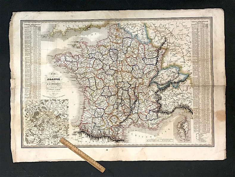
LORAIN (A.)
Carte de la France divisée en 86 départements et 20 Divisions Militaires.
Paris, Dopter, 1836. 77,5 x 52,5 cm à la cuvette + marges. Marges 3 cm environ.
書籍販売業者の参照番号
: 33716
|
|
|
LORD BYRON
Le oélerinage de Childe-Harold.
Henri Beziat editeur libraire, sans date, etat moyen, 220 pages, in12 broché, papier jauni, pages mal massicotées.
書籍販売業者の参照番号
: 9140
|
|
|
Lord Walter/Pugliese Paul J. maps
Lonely Vigil: Coastwatchers of the Solomons
NY: Viking 1977. 1st printing. VG/VG dust jacket price clipped dust jacket. xiv 322 p. photos maps map on endpapers index 8vo; Viking hardcover
書籍販売業者の参照番号
: 54358 ISBN : 0670437654 9780670437658

|
|
|
Lord Walter/Pugliese Paul J. maps
Lonely Vigil: Coastwatchers of the Solomons
NY: Viking 1977. 1st printing. VG/Good dust jacket price clipped dust jacket tears to edges of dust jacket very slightly cocked. xiv 322 p. photos maps map on endpapers index 8vo; Viking hardcover
書籍販売業者の参照番号
: 25246 ISBN : 0670437654 9780670437658
|
|
|
LOSE (Caroline);
[VENISE] Vedute di Venezia.
Milano Frat. Bettalli circa 1820 316 x 411 mm.
書籍販売業者の参照番号
: LBW0028a

|
|
|
LOSADA, Juan Cayetano (1766-1846).
Breves Tratados de Esfera y Geografía Universal, con algunas noticias históricas, en especial en lo perteneciente a España, y un Apéndice de Geografía Antigua y otro de Cronología, para instrucción de la juventud.
Madrid, Imprenta de Don Eusebio Aguado, 1839. 8vo. menor; 4 hojas, 246 pp., 1 h. Figuras entre el texto, un estado plegado "Distancia respectiva y número de habitantes de Madrid y de las principales capitales de provincia de España" y 6 mapas plegados coloreados de época. Encuadernación de época en piel.
|
|
|
LOT
Carte d?partementale couleurs au 1/200 000?me. Sans date.
Une feuille. 56x76 cm.
|
|
|
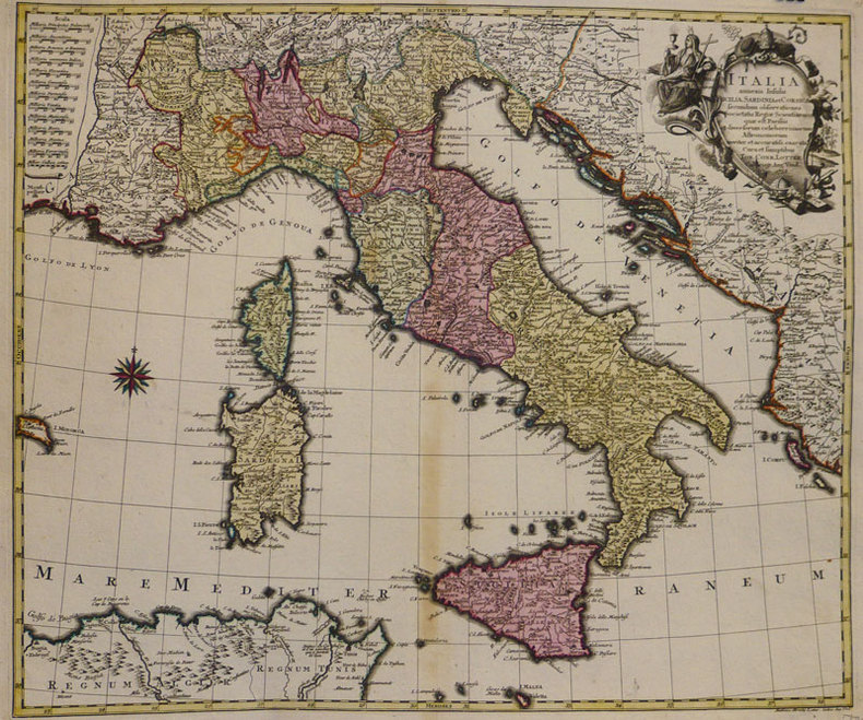
LOTTER (Tobias Conrad);
Italia annexis insulis Sicilia, Sardinia et Corsica.
Augsbourg 1758 476 x 568 mm.
書籍販売業者の参照番号
: LBW-935
|
|
|
LOT ET GARONNE
Carte d?partementale.
Une feuille 60x80 cm repli?e.
|
|
|
LOT ET GARONNE
Carte d?partementale. Sans date.
1 feuille 50x65 cm repli?e.
|
|
|
Lotter, Gebr.:
Karte von West-Russland. Von 2 Platten gedruckt und in Hochformat zusammengesetzt. Altkolorierte Kupferstichkarte.
Format (Blattgröße): 69 x 48 cm. *Im linken unteren Viertel mit 2 alten Tintenflecken (1 weiterer am Unterrand). Ansonsten sauber und gut erhalten Landkarten de
|
|
|
Lotter, Tobias Conrad
Marchionatus Lusatiae Superioris Felicissimo Polaniae, Regis, Electoris Saxoniae, sceptro florens, Dynastiis et Praefecturis suis distributus nova accuratione Tob. Conradi Lotter Geogr. delineatus in Augusta. [Altkolorierter Original-Kupferstich / original colored copper engraving].
o.J. Tobias Conrad Lotter, geboren 1717, gestorben am 14. Juli 1777. Kupferstecher, Kartograph und Verleger in Augsburg. [2 Warenabbildungen]
書籍販売業者の参照番号
: 12064DB

|
|
|
Lotter, Tobias Conrad
Theatrum belli Rußorum Victoriis illustratum sive Nova et accurata Turcicarum et Tartaricum ... [Altkolorierter Original-Kupferstich / original colored copper engraving].
o.J. [2 Warenabbildungen] Tobias Conrad Lotter, geboren 1717, gestorben am 14. Juli 1777. Kupferstecher, Kartograph und Verleger in Augsburg.
書籍販売業者の参照番号
: 13188DB

|
|
|
Lotter, Tobias Conrad (1717 - 1777):
"Novissimum Astronomiae, Geographiae, ac Gnomonicae compendium theoreticum. Altkolorierter Kupferstich von M. Seutter.
49 x 58 cm. Blatt: 52 x 66 cm. Theoretische und pratische Erklärung: in der Unterhalfte zwei Abb. von einer "Quadranten Uhr" und einer "Äquinoctial oder dem Mittel=kreis gleich ebene Universal Uhr" (je 24:24 cm), daruber der umfangreiche gestochene Erläuterungstext (in Latein). Zwischen den Abb. und dem Text in 2 Kolumnen sind Abb. von Instrumenten. - Unterrand knapp beschnitten, sonst breitrandig. Sauber und sehr gut erhalten. Graphiken de
|
|
|
Lotter, Tobias Conrad:
Nova et accuratißima Ducatus Wurtenbergici cum territoris conterminis. Kupferstichkarte des Herzogtums Württemberg von Tobias Lotter.
Format 50 x 57,5 cm. Blattgröße: 52 x 66 cm. *Mit Grenzkolorit und Markierung der Städte - die Kartuschen nicht koloriert. - Gut erhalten. Landkarten de
|
|
|
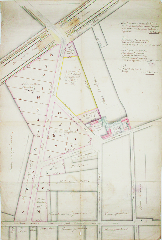
LOUIS-LE-GRAND (rue). MANUSCRIT.
[Plan d'aménagement de la rue Louis-le-Grand].
[circa 1703]. En 4 feuilles jointes de 530 x 760 mm.
書籍販売業者の参照番号
: LBW-4190
|
|
|
Loustal:
Assis debout couché.
Editions Christian Desbois, 1991. 7 aquarelles de Jacques Loustal presentées lors de l'exposition " assis, debout , couché " à la galerie Escale à Paris de 20 juin à 20 juillet 1991, présentées sous carte pliée et illustrée, sous forme de timbres.
書籍販売業者の参照番号
: 4342

|
|
|
LOUX F. / DUCROZ A. / POCACHARD A.
Chamonix autrefois : le Mont-Blanc et sa vallée.
Fontaine de Siloé, Coll. la Chronique de l'Autrefois, 1992, un volume grand in-8, broché, couv. illustrée, 215 pages, abondante iconographie ( cartes postales anciennes sépia) Bon état.
書籍販売業者の参照番号
: 6444
|
|
|
LOUX Françoise / DUCROZ Agnès / POCACHARD Antoine
Chamonix autrefois, le Mont-Blanc et sa vallée.
La Fontaine de Siloë, la Chronique de l'Autrefois, 1992, 215 p., broché, coins des plats légèrement cornés, bon état.
書籍販売業者の参照番号
: 94789
|
|
 検索結果のメールを受信する
 PDFファイルの検索結果をダウンロード
 RSSフィード


