|
Münster Sebastian (1488 - 1552)
(Roma)
Tavola tratta dalla Cosmographiae Universalis, edizione in tedesco, Basilea, seconda metà del XVI secolo.La Cosmographiae Universalis di Sebastian Münster (1488-1552), stampata per la prima volta Basilea nel 1544 dall’editore Heinrich Petri, venne più volte aggiornata e aumentata di nuove carte geografiche e rappresentazioni urbane nelle sue numerose edizioni che arrivano all’inizio del secolo successivo. Münster aveva lavorato a raccogliere informazioni al fine di ottenere un'opera che non deludesse le aspettative e, dopo un'ulteriore pubblicazione in tedesco abbellita da 910 stampe su legno, giunse nel 1550 all'edizione definitiva in latino, illustrata da 970 silografie. Vi furono poi numerose edizioni in diverse lingue, fra cui latino, francese, italiano, inglese e ceco. Dopo la sua morte di Münster (1552), Heinrich Petri prima, e il figlio Sebastian poi, continuarono la pubblicazione dell’opera. La Cosmographia universalis fu uno dei libri più popolari e di successo del XVI secolo, e vide ben 24 edizioni in 100 anni: l'ultima edizione tedesca venne pubblicata nel 1628, molto tempo dopo la morte dell'autore. La Cosmographia conteneva non solo le ultime mappe e vedute di tutte le città più famose, ma anche una serie di notizie enciclopediche di dettagli relative al mondo conosciuto, e sconosciuto. Il particolare successo anche commerciale di quest'opera fu dovuto in parte alle belle incisioni (tra i cui autori si possono citate Hans Holbein il Giovane, Urs Graf, Hans Rudolph Manuel Deutsch, David Kandel). Silografia, bella coloritura a mano, in buone condizioni. Plate taken from the Cosmographiae Universalis, German edition, Basel, second half of the 16th Century. The Cosmographiae Universalis of Sebastian Münster (1488-1552), printed for the first time in Basel in 1544 by the publisher Heinrich Petri, was updated several times and increased with new maps and urban representations in its many editions until the beginning of the next century. Münster had worked to collect information in order to obtain a work that did not disappoint expectations and, after a further publication in German embellished with 910 woodblock prints, arrived in 1550 to the final edition in Latin, illustrated by 970 woodcuts. There were then numerous editions in different languages, including Latin, French, Italian, English and Czech. After his death in Münster (1552), Heinrich Petri first, and then his son Sebastian, continued the publication of the work. The Cosmographia universalis was one of the most popular and successful books of the 16th century, and saw as many as 24 editions in 100 years: the last German edition was published in 1628, long after the author's death. The Cosmographia contained not only the latest maps and views of all the most famous cities, but also a series of encyclopedic details related to the known, and unknown, world. The particular commercial success of this work was due in part to the beautiful engravings (among whose authors can be mentioned Hans Holbein the Younger, Urs Graf, Hans Rudolph Manuel Deutsch, David Kandel). Woodcut, beautiful hand-coloring, in good condition.

|
|
|
Münster Sebastian (1488 - 1552)
Das Under Buch
Tavola tratta dalla Cosmographiae Universalis, edizione in tedesco, Basilea, seconda metà del XVI secolo.La Cosmographiae Universalis di Sebastian Münster (1488-1552), stampata per la prima volta Basilea nel 1544 dall’editore Heinrich Petri, venne più volte aggiornata e aumentata di nuove carte geografiche e rappresentazioni urbane nelle sue numerose edizioni che arrivano all’inizio del secolo successivo. Münster aveva lavorato a raccogliere informazioni al fine di ottenere un'opera che non deludesse le aspettative e, dopo un'ulteriore pubblicazione in tedesco abbellita da 910 stampe su legno, giunse nel 1550 all'edizione definitiva in latino, illustrata da 970 silografie. Vi furono poi numerose edizioni in diverse lingue, fra cui latino, francese, italiano, inglese e ceco. Dopo la sua morte di Münster (1552), Heinrich Petri prima, e il figlio Sebastian poi, continuarono la pubblicazione dell’opera. La Cosmographia universalis fu uno dei libri più popolari e di successo del XVI secolo, e vide ben 24 edizioni in 100 anni: l'ultima edizione tedesca venne pubblicata nel 1628, molto tempo dopo la morte dell'autore. La Cosmographia conteneva non solo le ultime mappe e vedute di tutte le città più famose, ma anche una serie di notizie enciclopediche di dettagli relative al mondo conosciuto, e sconosciuto. Il particolare successo anche commerciale di quest'opera fu dovuto in parte alle belle incisioni (tra i cui autori si possono citate Hans Holbein il Giovane, Urs Graf, Hans Rudolph Manuel Deutsch, David Kandel). Silografia, bella coloritura a mano, in buone condizioni. Plate taken from the Cosmographiae Universalis, German edition, Basel, second half of the 16th Century. The Cosmographiae Universalis of Sebastian Münster (1488-1552), printed for the first time in Basel in 1544 by the publisher Heinrich Petri, was updated several times and increased with new maps and urban representations in its many editions until the beginning of the next century. Münster had worked to collect information in order to obtain a work that did not disappoint expectations and, after a further publication in German embellished with 910 woodblock prints, arrived in 1550 to the final edition in Latin, illustrated by 970 woodcuts. There were then numerous editions in different languages, including Latin, French, Italian, English and Czech. After his death in Münster (1552), Heinrich Petri first, and then his son Sebastian, continued the publication of the work. The Cosmographia universalis was one of the most popular and successful books of the 16th century, and saw as many as 24 editions in 100 years: the last German edition was published in 1628, long after the author's death. The Cosmographia contained not only the latest maps and views of all the most famous cities, but also a series of encyclopedic details related to the known, and unknown, world. The particular commercial success of this work was due in part to the beautiful engravings (among whose authors can be mentioned Hans Holbein the Younger, Urs Graf, Hans Rudolph Manuel Deutsch, David Kandel). Woodcut, beautiful hand-coloring, in good condition.

|
|
|
Münster Sebastian (1488 - 1552)
Der Statt Rom in aller Welt bekannt Contrashetung nach jetziger gelegenheit
Bella veduta di Roma tratta dalla Cosmographiae Universalis, edizione in tedesco, Basilea fine del XVI secolo.La veduta di Munster cattura con raffinatezza le mura fortificate e i Sette Colli della Città Eterna, con attività significative lungo il fiume Tevere. Molti dei principali monumenti di Roma sono chiaramente identificabili. In basso una legenda che individua circa 23 punti di riferimento."Seppure incisa mezzo secolo dopo le piante del Bergomense e dello Schedel, la veduta ritrae la città come si presentava alla fine del '400 attingendo al medesimo prototipo comunemente indicato nel panorama di Mantova a sua volta ripreso da un presunto ma tuttora sconosciuto panorama inciso nella bottega di Francesco Rosselli verso il 1485. L'immagine venne inserita in una delle opere più note del '500, la Cosmographiae Universalis per la prima volta edita in latino nel 1550 e poi ristampata più volte in italiano, francese e tedesco. […] è stata più volte rilevata dai critici l'assenza del Colosseo dall'autore stesso curiosamente giustificata alla lettera G della legenda "per mancanza di spazio". Oltre ai Dioscuri presso le Terme di Diocleziano, presenti anche nelle piante di Bergomense e Schedel, è qui indicata acnhe la statua equestre del Marco Aurelio nella sua originale collocazione presso San Giovanni in Laterano da cui fu spostata nel 1538 per la visista di Carlo V a Roma e collocata da Michelangelo in Campidoglio. È ancora in piedi la Meta Romuli sebbene demolita nel 1499 e le due edicole alla fine di Castel Sant'Angelo demolite dopo il Sacco di Roma del 1527. L'edificio più recente raffigurato è il Belvedere Vaticano (1485/87" (cfr. Marigliani p. 118). La Cosmographiae Universalis di Sebastian Münster (1488-1552), stampata per la prima volta Basilea nel 1544 dall’editore Heinrich Petri, venne più volte aggiornata e aumentata di nuove carte geografiche e rappresentazioni urbane nelle sue numerose edizioni che arrivano all’inizio del secolo successivo. Münster aveva lavorato a raccogliere informazioni al fine di ottenere un'opera che non deludesse le aspettative e, dopo un'ulteriore pubblicazione in tedesco abbellita da 910 stampe su legno, giunse nel 1550 all'edizione definitiva in latino, illustrata da 970 silografie. Vi furono poi numerose edizioni in diverse lingue, fra cui latino, francese, italiano, inglese e ceco. Dopo la sua morte di Münster (1552), Heinrich Petri prima, e il figlio Sebastian poi, continuarono la pubblicazione dell’opera. La Cosmographia universalis fu uno dei libri più popolari e di successo del XVI secolo, e vide ben 24 edizioni in 100 anni: l'ultima edizione tedesca venne pubblicata nel 1628, molto tempo dopo la morte dell'autore. La Cosmographia conteneva non solo le ultime mappe e vedute di tutte le città più famose, ma anche una serie di notizie enciclopediche di dettagli relative al mondo conosciuto, e sconosciuto. Il particolare successo anche commerciale di quest'opera fu dovuto in parte alle belle incisioni (tra i cui autori si possono citate Hans Holbein il Giovane, Urs Graf, Hans Rudolph Manuel Deutsch, David Kandel). Silografia, bella coloritura a mano, in buone condizioni. BibliografiaA. P. Frutaz, "Le piante di Roma", XCVIII, tav. 170; C. Marigliani, "Le Piante di Roma delle collezioni private", tav. 14; M. Gori Sassoli (a cura di), "Roma Veduta" p. 140, n. 6; Scaccia Scarafoni, n. 126. Munster's view captures a fine sense of the fortified walls and Seven Hills of the Eternal City, with significant activity along the Tiber River. Many of Rome's great landmarks are clearly identifiable in this important early view. The key at the bottom locates approximately 23 landmarks.Although engraved half a century later from the maps by Bergomensis and Schedel, the view depicts the city as it was at the end of the 15th century, drawing on the same prototype commonly indicated in the panorama of Mantua in turn taken from a still unknown panorama engraved in the workshop of Francesco Rosselli around 1485. The image was included in one of the most famous works of the '500, the Cosmographiae Universalis for the first time published in Latin in 1550 and then reprinted several times in Italian, French and German. The absence of the Colosseum - justified by the author himself by the letter G of the legend "for lack of space" - has been noted several times by critics. In addition to the Dioscuri at the Baths of Diocletian, also present in the plants of Bergomensis and Schedel, the equestrian statue of Marcus Aurelius in its original location near San Giovanni in Laterano, from which it was moved in 1538 for the visist of Charles V in Rome and placed by Michelangelo in the Capitoline Hill, is here indicated. It is still standing the Meta Romuli although demolished in 1499 and the two "edicole" at the end of Castel Sant'Angelo, demolished after the Sack of Rome of 1527. The most recent building depicted is the Vatican Belvedere, built in 1485/87. (see Marigliani p. 118). Plate taken from the Cosmographiae Universalis, German edition, Basel, second half of the 16th Century. The Cosmographiae Universalis of Sebastian Münster (1488-1552), printed for the first time in Basel in 1544 by the publisher Heinrich Petri, was updated several times and increased with new maps and urban representations in its many editions until the beginning of the next century. Münster had worked to collect information in order to obtain a work that did not disappoint expectations and, after a further publication in German embellished with 910 woodblock prints, arrived in 1550 to the final edition in Latin, illustrated by 970 woodcuts. There were then numerous editions in different languages, including Latin, French, Italian, English and Czech. After his death in Münster (1552), Heinrich Petri first, and then his son Sebastian, continued the publication of the work. The Cosmographia universalis was one of the most popular and successful books of the 16th century, and saw as many as 24 editions in 100 years: the last German edition was published in 1628, long after the author's death. The Cosmographia contained not only the latest maps and views of all the most famous cities, but also a series of encyclopedic details related to the known, and unknown, world. The particular commercial success of this work was due in part to the beautiful engravings (among whose authors can be mentioned Hans Holbein the Younger, Urs Graf, Hans Rudolph Manuel Deutsch, David Kandel). Woodcut, beautiful hand-coloring, in good condition. BibliografiaA. P. Frutaz, "Le piante di Roma", XCVIII, tav. 170; C. Marigliani, "Le Piante di Roma delle collezioni private", tavv. 11/14; M. Gori Sassoli (a cura di), "Roma Veduta" p. 140, n. 6; Scaccia Scarafoni, n. 126.

|
|
|
Münster Sebastian (1488 - 1552)
Roma
Tavola tratta dalla Cosmographiae Universalis, edizione in tedesco, Basilea, seconda metà del XVI secolo.La Cosmographiae Universalis di Sebastian Münster (1488-1552), stampata per la prima volta Basilea nel 1544 dall’editore Heinrich Petri, venne più volte aggiornata e aumentata di nuove carte geografiche e rappresentazioni urbane nelle sue numerose edizioni che arrivano all’inizio del secolo successivo. Münster aveva lavorato a raccogliere informazioni al fine di ottenere un'opera che non deludesse le aspettative e, dopo un'ulteriore pubblicazione in tedesco abbellita da 910 stampe su legno, giunse nel 1550 all'edizione definitiva in latino, illustrata da 970 silografie. Vi furono poi numerose edizioni in diverse lingue, fra cui latino, francese, italiano, inglese e ceco. Dopo la sua morte di Münster (1552), Heinrich Petri prima, e il figlio Sebastian poi, continuarono la pubblicazione dell’opera. La Cosmographia universalis fu uno dei libri più popolari e di successo del XVI secolo, e vide ben 24 edizioni in 100 anni: l'ultima edizione tedesca venne pubblicata nel 1628, molto tempo dopo la morte dell'autore. La Cosmographia conteneva non solo le ultime mappe e vedute di tutte le città più famose, ma anche una serie di notizie enciclopediche di dettagli relative al mondo conosciuto, e sconosciuto. Il particolare successo anche commerciale di quest'opera fu dovuto in parte alle belle incisioni (tra i cui autori si possono citate Hans Holbein il Giovane, Urs Graf, Hans Rudolph Manuel Deutsch, David Kandel). Silografia, bella coloritura a mano, in buone condizioni. Plate taken from the Cosmographiae Universalis, German edition, Basel, second half of the 16th Century. The Cosmographiae Universalis of Sebastian Münster (1488-1552), printed for the first time in Basel in 1544 by the publisher Heinrich Petri, was updated several times and increased with new maps and urban representations in its many editions until the beginning of the next century. Münster had worked to collect information in order to obtain a work that did not disappoint expectations and, after a further publication in German embellished with 910 woodblock prints, arrived in 1550 to the final edition in Latin, illustrated by 970 woodcuts. There were then numerous editions in different languages, including Latin, French, Italian, English and Czech. After his death in Münster (1552), Heinrich Petri first, and then his son Sebastian, continued the publication of the work. The Cosmographia universalis was one of the most popular and successful books of the 16th century, and saw as many as 24 editions in 100 years: the last German edition was published in 1628, long after the author's death. The Cosmographia contained not only the latest maps and views of all the most famous cities, but also a series of encyclopedic details related to the known, and unknown, world. The particular commercial success of this work was due in part to the beautiful engravings (among whose authors can be mentioned Hans Holbein the Younger, Urs Graf, Hans Rudolph Manuel Deutsch, David Kandel). Woodcut, beautiful hand-coloring, in good condition.

|
|
|
N/ A and Maps Text Illustrations etc throuhgout
Lake District The; Britain's Largest National Park
Paperback. Very Good. Very good condition. Same day dispatch Mon-Fri from the UK if ordered by 1pm. paperback
Referentie van de boekhandelaar : EKG-C7E-5G2
|
|
|
n/a
Chemins De Fer Federaux SUISSE CARTE DU TOURISTE
Berne: Le Service de Publicite Des Chemins De Fer Federaux 1907. A fine tourist map of Switzerland dated 1907. Printed in colour on thick paper folding 58cm x 81cm. Scale 1: 450000. To the reverse of the map are printed tables and tourist information in French Condition is very good with a little general wear only. A very good copy. Deuxieme Edition. Very Good. 58 X 81CM. Map. Le Service de Publicite Des Chemins De Fer Federaux unknown
Referentie van de boekhandelaar : 011909

|
|
|
n/a
Karte Nr. 35. Ravenstein's Rad- u. Automobil-Karte f�r den Regierungsbezirk LIEGNITZ Sowie Die Umgend Von Gorlitz Und Zittau. 1: 300 000.
Frankfurt: Ludwig Ravenstein No date circa 1910 Cloth backed coloured map - approximately 80 x 60cm. In very good condition some - towns underlined in blue. A very good copy. Map. Very Good. Ludwig Ravenstein Hardcover
Referentie van de boekhandelaar : 007202

|
|
|
n/a
Northeastern Official AAA Tour Book
Washington DC: American Automobile Association 1927. Softcover. Good/no jacket. 400 p maps throughout 24cm tall octavo. One section has brief descriptions of principal northeastern cities towns resorts; another section has detailed logs and maps for principal routes. Also many advertisements for hotels and resorts. Folded northeastern states highway map affixed to inside rear cover. Covers show some soil otherwise a fine copy. American Automobile Association paperback
Referentie van de boekhandelaar : 001379
|
|
|
n/a
Western Tour Book Volume II
Washington DC: American Automobile Association no date 1936. Softcover. Fine/no jacket. 608p illustrations maps 23cm tall octavo. Fold-out index and mileage map inside rear cover the general reference map is missing. Bottom edge shows red marker line. American Automobile Association paperback
Referentie van de boekhandelaar : 002288
|
|
|
N/A.
"Libro del Conosçimiento de todos los Regnos et Tierras et Señorios que son por el Mundo, et de las señales et armas que han" Edición facsimilar, transcripción, estudio y notas del Manuscrito Z de la Bayerische Staatsbibliothek, de Munich [Cod. Hisp. 150] procedente de la "Alacena de Zurita", realizada por Maria Jesús Lacarra, Maria del Carmen Lacarra Ducay y Alberto Montaner.
Zaragoza, 1999. Folio; 279 pp., cincuenta y dos de ellas y tres láminas, dos de ellas plegadas, con la reproducción facsímilar del Códice. Cubiertas originales.

|
|
|
N/A.
GIFTS OF TAMAR AND TEDDY KOLLEK TO THE ISRAEL MUSEUM JERUSALEM. GEMS OF ANTIQUITY. JERUSALEM IN MAPS AND VIEWS,
, Jerusalem, The Israel Museum, 1990., Bound, blue cloth, white illustrated dustjacket, decorated inner platters, 220 x 225mm.,133(VII)pp., profound illustration in color and b/w. ISBN 9652781118.
Referentie van de boekhandelaar : 16791
|
|
|
N/A.
Paris en Main. La Vrai Guide d'après un plan fractionné par arrondissements et divisé par quartiers.
Paris, A. V. Vallad fils et Cie., 1886. 4to.; 12-45 pp., 20 hojas sin paginar, 20 planos impresos en color y un plano plegado. Encuadernación original en tela estampada.

|
|
|
NADEAU Gilles
BOURGOGNE 1900.
Daniel et cie éditeurs, 1976. In-4 relié pleine toile tissée écrue, premier plat illustré d'une carte en couleurs, 126 pages, abondamment illustré de cartes postales anciennes en reproduction, légendées. Très bon exemplaire, bien frais.
Referentie van de boekhandelaar : 10845
|
|
|
NAESSENS, HERMAN (VERTALING
Museum van de Kleine Koningin. [Het fietsmuseum van Falmignoul]
Flamignoul, Fietsmuseum, s.d. (ca.1970) Gebonden, kunstleder met titelillustr., 209pp., 16.5x24.5cm., oblong, ills. in z/w., goede staat. Zeldzaam!!
Referentie van de boekhandelaar : 46143
|
|
|
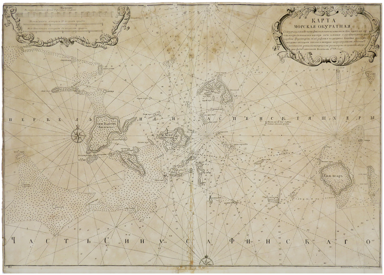
NAGAEV (Aleksei Ivanovich).
[GOLFE de FINLANDE] [Carte en caractères cyrilliques du Golfe de Finlande].
[Saint-Pétersbourg], 1748 [1757]. 549 x 781 mm.
Referentie van de boekhandelaar : LBW-5907
|
|
|
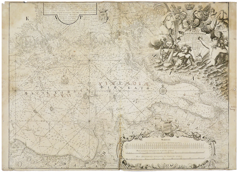
NAGAEV (Aleksei Ivanovich).
[SAINT-PÉTERSBOURG/GOLFE de FINLANDE] [Carte en caractères cyrilliques du Golfe de Finlande avec Saint-Pétersbourg].
[Saint-Pétersbourg], 1750 [1757]. 555 x 730 mm.
Referentie van de boekhandelaar : LBW-5890
|
|
|
Nagel, Joseph.
Grund-Riß der kay. königl. Residenz-Stadt Wien. Unter glorwürdigster Regierung Beyder May.ten Josephs des II.ten Röm. Kaysers und Mariä Theresiä Röm. Kayserin [...] Unter der Direction dero Hof Mathematici Joseph Nagel aufgenommen von dem N.D. Reg. Ingenieur Franz Gruß und Joseph Neussner im Jahr 1770. Vienna, zu haben auf der Wieden in der Plenkler Gasse No. 316, [1774].
Four-plate engraving by J. E. Mansfeld, mounted on cloth and framed under glass. 131 x 162 cm. Probably the most monumental layout plan of the Vienna inner city ever published, doubling the scale of Nagel's better-known (and more common) plan of Vienna and its suburbs (1781), and self-published as early as 1774. Nagel had begun his surveying task shortly after completion of the re-numbering of houses in 1770. "Probably completed in October 1774" (cf. Dörflinger). - Slight browning to margins, otherwise fine. Extremely rare. Dörflinger, Österreichische Karten des 18. Jhs. I, 71 and note 115. Not in Mayer or Eckl colls.

|
|
|
Nagy, Thomas L.
Ottawa in Maps - A Brief Cartographical History of Ottawa (Canada) 1825-1973 / Ottawa Par Les Cartes - Breve Histoire Cartographique De La Ville D'Ottawa (Catalogue No. SA2-72/1974)
[12], 87 pages. Bilingual English/French. Printed upon glossy stock. Illustrated throughout in blue and brown. "From its very beginning to the present time, the history of the nation's capital unfolds from the cartographical material housed in the National Map Collection. The collection includes over three hundred maps directly relating to the Ottawa area; the selected maps reproduced in this book tell the highlights of the story. A list of Ottawa area maps appears in the appendix. This list should be of great value to historical researchers and all others interested in Canada's capital." - Preface. Moderate external wear. Contents clean and unmarked. A sound copy of this informative reference. Bishop p.36. Book

|
|
|
NANCY
Carte d'Etat-Major au 1/200 000?. Fin XIXe.
1 feuille repli?e. 32x49 cm.
|
|
|
NANSEN (Fridtjof)
"Vers le Pôle." Récit d'exploration traduit et abrégé par Ch. RABOT enrichi de 100 illustrations d'après les photographies et les dessins de Nansen (gravures, photogravures, cartes, dessins).
Paris, Ernest Flammarion éd. s.d. (vers 1897). Bon exemplaire relié, reliure pleine toile d'éd., dos avec titres dorés, tranches dorées, pet. In-8, VIII + 466 pages avec annexes dont portrait gravé de l'auteur, préface du traducteur, introduction, cartes, appendices et table des matières. Taches sur la reliure, rousseurs.
Referentie van de boekhandelaar : AUB-7056
|
|
|
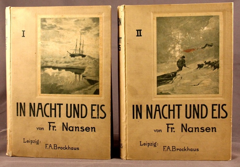
NANSEN Fridtjof:
In Nacht und Eis. Die Norwegische Polarexpedition. 1893-1896. Mit einem Beitrag von Kapitän Sverdrup.
Leipzig, F.A.B. Brockhaus, 1897. 2 vol. in-8 de X-527 + VIII-507 pages, pleine percaline grise d’éditeur (sans doute blanche autrefois), dos lisses, 1ers plats illustrés. Mors fendus sur quelques centimètres au vol. 1.
Referentie van de boekhandelaar : 2105
|
|
|
Nantet, Bernard
Malta
No marks or inscriptions. No creasing to covers or to spine. A very clean very tight copy with bright unmarked boards and no bumping to corners. Dust jacket not price clipped or marked with chips and nicks to upper and lower edges. 195pp. An account of 5000 years of history of Malta, very well illustrated with the culture, architecture, industry and leisure of the island today. Text in English, French and German. Undated ca 1980.

|
|
|
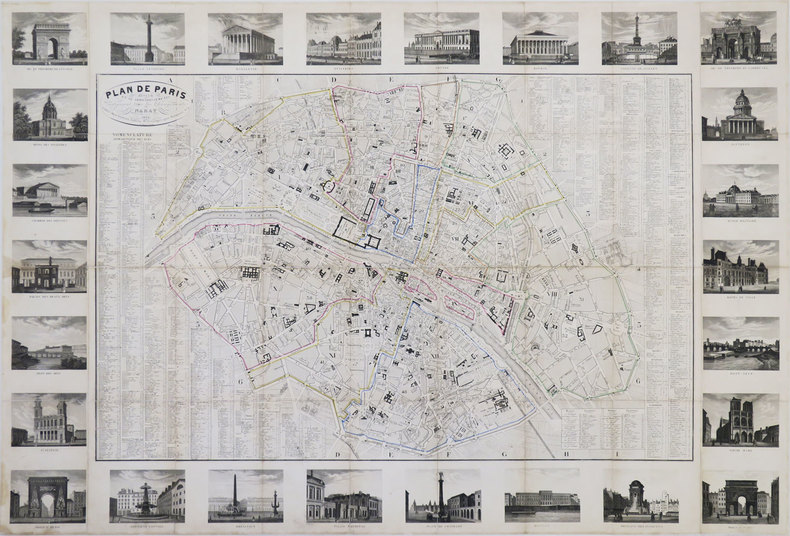
NARAT.
Plan de Paris divisé en 12 arrondissements, indiquant tous les changements.
Paris, Danlos, 1830. En 36 sections jointes et montées sur toile de 590 x 877 mm.
Referentie van de boekhandelaar : LBW-3442
|
|
|
National Geographic Maps National Geographic Maps Editor National Geographic Maps Illustrator
#752 Boundary Waters Canoe Area East- MN
Natl Geographic Society Maps 2010-05-17. 1. Map. Used:Good. Natl Geographic Society Maps unknown
Referentie van de boekhandelaar : DADAX1566955025 ISBN : 1566955025 9781566955027

|
|
|
National Geographic Maps National Geographic Maps Editor National Geographic Maps Illustrator
#753 Boundary Waters Canoe Area West. Superior National Forest Nat G
Natl Geographic Society Maps 2010-05-17. 1. Map. Used:Good. Natl Geographic Society Maps unknown
Referentie van de boekhandelaar : DADAX1566955033 ISBN : 1566955033 9781566955034

|
|
|
National Geographic Maps
100 Boulder/Golden - CO Natg National Geographic Maps: Trails Illustrated
National Geographic Maps 2010-04-10. Map. Map. Good. National Geographic Maps unknown
Referentie van de boekhandelaar : SONG1566953359 ISBN : 1566953359 9781566953351

|
|
|
National Geographic Maps
101 Cache La Pouder/ Big Thompson -CO
Natl Geographic Society Maps 2003-01-01. 03. Map. Used:Good. Natl Geographic Society Maps unknown
Referentie van de boekhandelaar : DADAX1566953901 ISBN : 1566953901 9781566953900
|
|
|
National Geographic Maps
102 Indian Peaks/ Gold Hill Trail -CO natg Trails Illustrated
Natl Geographic Society Maps 2005-08-01. 03. Map. Used:Good. Natl Geographic Society Maps unknown
Referentie van de boekhandelaar : DADAX1566952751 ISBN : 1566952751 9781566952750

|
|
|
National Geographic Maps
105 Tarryall Mountains/ Kenosha Pass- C natg Trails Illustrated
Natl Geographic Society Maps 2006-01-01. 3. Map. Used:Good. Natl Geographic Society Maps unknown
Referentie van de boekhandelaar : DADAX1566952867 ISBN : 1566952867 9781566952866
|
|
|
National Geographic Maps
116 Hahns Peak/Steamboat Lake -CO natg Trails Illustrated
Natl Geographic Society Maps 2007-06-01. 3. Map. Used:Good. Natl Geographic Society Maps unknown
Referentie van de boekhandelaar : DADAX1566952808 ISBN : 1566952808 9781566952804

|
|
|
National Geographic Maps
117 Clark/ Buffalo Park -CO natg Trails Illustrated
Natl Geographic Society Maps 2006-09-01. Map. Map. Used:Good. Natl Geographic Society Maps unknown
Referentie van de boekhandelaar : DADAX1566952859 ISBN : 1566952859 9781566952859
|
|
|
National Geographic Maps
118 Steamboat Spring/Rabbit Ears Pass-C natg Ti - Other Rec. Areas
Natl Geographic Society Maps 2007-01-01. 3. Map. Used:Good. Natl Geographic Society Maps unknown
Referentie van de boekhandelaar : DADAX1566953383 ISBN : 1566953383 9781566953382
|
|
|
National Geographic Maps
120 State Bridge/Burns Trail Map CO natg Trails Illustrated
Natl Geographic Society Maps 2001-01-01. 2. Map. Used:Good. Natl Geographic Society Maps unknown
Referentie van de boekhandelaar : DADAX1566952875 ISBN : 1566952875 9781566952873
|
|
|
National Geographic Maps
128 Maroon Bells/Redstone/ Marble CO natg National Geographic Maps: Trails Illustrated
Natl Geographic Society Maps 2005-09-01. Map. Used:Good. Natl Geographic Society Maps unknown
Referentie van de boekhandelaar : DADAX1566952484 ISBN : 1566952484 9781566952484

|
|
|
National Geographic Maps
132 Gunnison/Pitkin Trail CO Trails Illustrated
Natl Geographic Society Maps 1999-01-01. Map. Used:Good. Natl Geographic Society Maps unknown
Referentie van de boekhandelaar : DADAX1566953960 ISBN : 1566953960 9781566953962
|
|
|
National Geographic Maps
133 Kebler Pass/Paonia Reservoir CO natg National Geographic Maps: Trails Illustrated
Natl Geographic Society Maps 1999-01-01. Map. Map. Used:Good. Natl Geographic Society Maps unknown
Referentie van de boekhandelaar : DADAX1566953979 ISBN : 1566953979 9781566953979
|
|
|
National Geographic Maps
136 Grand Mesa CO natg Trails Illustrated
Natl Geographic Society Maps 2006-06-01. 3. Map. Used:Good. Natl Geographic Society Maps unknown
Referentie van de boekhandelaar : DADAX1566953847 ISBN : 1566953847 9781566953849
|
|
|
National Geographic Maps
137 Pikes Peak Canon City CO natg Ti - Other Rec. Areas
National Geographic Maps 2010-06-10. Map. Map. Used:Good. National Geographic Maps unknown
Referentie van de boekhandelaar : DADAX1566953987 ISBN : 1566953987 9781566953986

|
|
|
National Geographic Maps National Geographic Maps Editor National Geographic Maps Illustrator
140 Weminuche Widerness Trail Map- CO natg National Geographic Maps: Trails Illustrated
Natl Geographic Society Maps 2007-01-01. 5. Map. Used:Good. Natl Geographic Society Maps unknown
Referentie van de boekhandelaar : DADAX1566952913 ISBN : 1566952913 9781566952910

|
|
|
National Geographic Maps
141 Silverton/Ouray/Telluride/LakeCityC natg National Geographic Maps: Trails Illustrated
Natl Geographic Society Maps 2004-05-01. Map. Used:Good. Natl Geographic Society Maps unknown
Referentie van de boekhandelaar : DADAX1566953405 ISBN : 1566953405 9781566953405

|
|
|
National Geographic Maps National Geographic Maps Editor National Geographic Maps Illustrator
147 Uncompahgre Plateau North CO natg Trails Illustrated
Natl Geographic Society Maps 2011-09-15. 1. Map. Used:Good. Natl Geographic Society Maps unknown
Referentie van de boekhandelaar : DADAX1566955831 ISBN : 1566955831 9781566955836
|
|
|
National Geographic Maps
155 Rand/Stillwater Pass Trail Map CO natg National Geographic Maps: Trails Illustrated
Natl Geographic Society Maps 2007-01-01. 3. Map. Used:Good. Natl Geographic Society Maps unknown
Referentie van de boekhandelaar : DADAX1566952824 ISBN : 1566952824 9781566952828
|
|
|
National Geographic Maps
220 Dinosaur National Park- CO Trails Illustrated
National Geographic Maps 2010-07-10. Map. Map. Used:Good. National Geographic Maps unknown
Referentie van de boekhandelaar : DADAX1566954037 ISBN : 1566954037 9781566954037
|
|
|
National Geographic Maps
224 Organ Pipe Cactus - AZ National Geographic Maps: Trails Illustrated
Natl Geographic Society Maps 2006-06-01. 01. Map. Used:Good. Natl Geographic Society Maps unknown
Referentie van de boekhandelaar : DADAX1566952131 ISBN : 1566952131 9781566952132
|
|
|
National Geographic Maps
235 Apostle Islands Lakeshore -WI natg National Geographic Maps: Trails Illustrated
Natl Geographic Society Maps 2007-03-01. 2. Map. Used:Good. Natl Geographic Society Maps unknown
Referentie van de boekhandelaar : DADAX1566953669 ISBN : 1566953669 9781566953665
|
|
|
National Geographic Maps
239 Badlands NP Trail Map - SD natg National Geographic Maps: Trails Illustrated
National Geographic Maps 2010-05-10. Map Rev. Map. Used:Good. National Geographic Maps unknown
Referentie van de boekhandelaar : DADAX1566954088 ISBN : 1566954088 9781566954082

|
|
|
National Geographic Maps
240 Isle Royale NP -MI natg National Geographic Maps: Trails Illustrated
Natl Geographic Society Maps 2006-09-01. 4. Map. Used:Good. Natl Geographic Society Maps unknown
Referentie van de boekhandelaar : DADAX1566953677 ISBN : 1566953677 9781566953672

|
|
|
National Geographic Maps
241 Big S.Fork National Recreation Area- TN Trails Illustrated
Natl Geographic Society Maps 2007-08-01. Map. Map. Used:Good. Natl Geographic Society Maps unknown
Referentie van de boekhandelaar : DADAX1566953545 ISBN : 1566953545 9781566953542

|
|
|
National Geographic Maps
244 Crater Lake -OR natg Trails Illustrated
Natl Geographic Society Maps 1998-01-01. 3. Map. Good. Natl Geographic Society Maps unknown
Referentie van de boekhandelaar : SONG1566953022 ISBN : 1566953022 9781566953023

|
|
|
National Geographic maps
252 Channel Islands -CA natg National Geographic Maps: Trails Illustrated
Natl Geographic Society Maps 2006-08-01. 3. Map. Used:Good. Natl Geographic Society Maps unknown
Referentie van de boekhandelaar : DADAX156695410X ISBN : 156695410X 9781566954105

|
|
 De zoekresultaten per email ontvangen
 Zoekresultaten downloaden als PDF
 RSS feed


