|
Olearius, Adam (1599-1671)
Vera delineatio provinciae fertilissimae Kilan olim Hyrcaniae ad mare Caspium sitae. [Kaspisches Meer]. Per Ad. Olearium.
O. O. (Paris), (Jean Dupuis), ( 1659). Kupferstich. Darstellung ca. 28 x 33 cm, Blattmaß 31 x 42 cm. Feinkartonpassepartout.
書籍販売業者の参照番号
: 78800

|
|
|
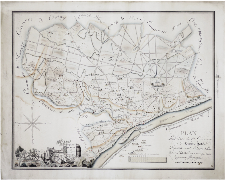
OLIVIER-JUSSEAUME.
[INDRE-et-LOIRE] Réunion de deux cartes manuscrites dessinées en 1816 par Olivier-Jusseaume, pour son oncle, Mr Fortin.
1816.
書籍販売業者の参照番号
: LBW-7448
|
|
|
OLIVIERI Bernardino (Roma, 1770 - ?)
Circoli per formare La Sfera Armillare
Foglio contenente delle sezioni di globo - in dodici segmenti - e altri elementi atti a costruire una sfera armillare. Il globo terrestre centrale è in 12 segmenti e avrebbe un diametro di circa 5,5 cm se costruito. La sfera armillare complessiva avrebbe un diametro di 28 cm. I vari anelli della sfera armillare comprendono l'equatore, il Tropico del Cancro, il Tropico del Capricorno, le zone e i cerchi polari e antartici. Tavola edita dalla Calcografia Camerale, Roma 1795 e tratta dal Nuovo Atlante Geografico Universale delineato sulle ultime osservazioni, edito a Roma dal 1792 fino al 1801, opera che la Calcografia Camerale commissionò al Cassini al fine di sostituire l’ormai obsoleto Mercurio Geografico della tipografia De Rossi. Bernardino Olivieri fu cartografo incisore presso la Calcografia Camerale di Roma sitauta nel Collegio di Propaganda Fide Incisione in rame, finemente colorata a mano, in ottime condizioni. Rara. This matching set of sheets contain the pieces to construct an armillary sphere. The central terrestrial globe is in 12 segments and would have a diameter of approximately 5.5 cm if constructed. The overall armillary sphere would have a diameter of 28 cm. The various rings of the armillary sphere include the equator, the Tropic of Cancer, the Tropic of Capricorn, the zones, and the Polar and Antarctic circles. Uncommon maps, published in the Nuovo Atlante Geografico Universale, that was commissioned to Cassini by the Calcografia Camerale, in order to replace the obsolete De Rossi's Mercurio Geografico. Bernardino Olivieri was a cartographer and engraver at the Calcografia Camerale di Roma located in the Collegio di Propaganda Fide. Copper engraving, finely hand colored, in very good condition. Rare.

|
|
|
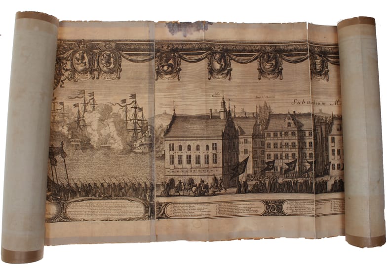
ONE OF THE LARGEST ENGRAVED FUNERAL PROCESSIONS - ERIK DAHLBERG.
Exequiae Serenissimi ac Potentiss: Principis ac Dni. Domini Caroli Gustavi Suecorum Gothorum et Wandalorum Regis d. 3. Nouemb. 1660 Holmiæ Celebratæ. Accuraté delineauit E.I. Dahlbergh. (The funeral procession of King Carl X Gustav of Sweden).
(Nürnberg, 1696). The large engraving of the procession through Stockholm being composed of 13 engraved plates joined together, measuring 30x450 cm. (Plates numb. 1-13). Some mostly marginal dampstains, some marginal tears, some brownspots mainly marginal. Upper margin of plate 3 partly gone. Margins strenghtened at verso with brown paper. Some variation to paperquality, but in general in good strong impressions.
書籍販売業者の参照番号
: 32611
|
|
|
ONE OF THE LARGEST ENGRAVED FUNERAL PROCESSIONS - ERIK DAHLBERG.
Exequiae Serenissimi ac Potentiss: Principis ac Dni. Domini Caroli Gustavi Suecorum Gothorum et Wandalorum Regis d. 3. Nouemb. 1660 Holmiæ Celebratæ. Accuraté delineauit E.I. Dahlbergh. (The funeral procession of King Carl X Gustav of Sweden).
(Nürnberg, 1696). The large engraving of the procession through Stockholm being composed of 13 engraved plates joined together, measuring 30x450 cm. (Plates numb. 1-13). Some mostly marginal dampstains, some marginal tears, some brownspots mainly marginal. Upper margin of plate 3 partly gone. Margins strenghtened at verso with brown paper. Some variation to paperquality, but in general in good strong impressions.
|
|
|
Orchard, Imbert
Floodland and Forest - Memories of the Chilliwack Valley - Sound Heritage Series Number 37
92 pages. Based upon 15 tape recorded interviews with people of the Chilliwack area conducted in the early 1960s. Replete with historical photos and maps. Book
|
|
|
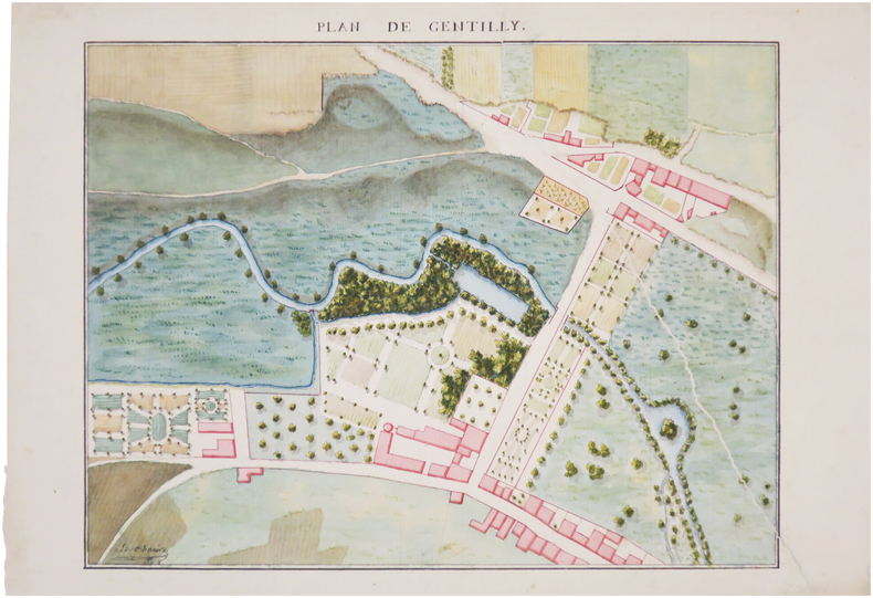
ORDINAIRE (Ed.).
[VAL-de-MARNE] Plan de Gentilly.
[milieu du XIXe siècle]. 23 x 33,5 cm.
書籍販売業者の参照番号
: LBW-7440
|
|
|
ORDNANCE SURVEY 1916
Carte De France Entoilée , ST OMER . Section Sheet 27° S.E., de La 1° Guerre Mondiale ( Map of France of Sheet 27° S.E. For the First War )
Ordnance Survey 1916 68 Cm X 88 Cm Carte entoilée illustrée . Plan de St Omer , Wisques , Quelmes , Acquin , forêt national de Tournehem , Norbécourt , Houlle , St Momelin au 1/20 000° en couleurs . L'entoilage ensanglanté par la blessure du soldat est imprimé d'un glossaire ( glossary ) français-anglais . Quelques défauts d'usages que l'on pardonnera vues les conditions dans lesquelles cette guerre de tranchées s'est déroulée . Histoire 1° Guerre Mondiale . - 1 p. , 250 gr.
書籍販売業者の参照番号
: 007289
|
|
|
ORDENER Paul.-
Les Sports. Jeu des Familles.-
Paris. Nathan. s.d. Jeu complet de 48 cartes illustrées en couleurs par Paul ORDENER, dans un coffret (160 x 118mm) de carton rouge orné d'une grande vignette couleurs. Tout petits défauts mais bon exemplaire bien complet de la règle du jeu (enfants de 7 à 12 ans).
書籍販売業者の参照番号
: ORD-7929
|
|
|
ORDANCE SURVEY
Ordnance Survey [Tourist] Map of Dorking & Leith Hill. One Inch to One Mile. ['Official Royal Arms' cover].
Folding coloured map on paper measuring 24 x 33 ins (approx. 61.0 x 84.0 cms) folding in 32 panels to 7.5 x 4.25 ins (approx. 19.0 x 11.0 cms), neat contemporary signature on front cover, one or two neat repairs at folds; original pictorial card wrappers, yapped edges, wrappers lightly age-soiled else a very good, bright, clean copy. The One Inch Tourist Map series was first published in 1924 with 'Official Royal Arms' artwork. The present copy is the 1929 revision; the cover is single red lineation on buff with black arms, red sheet name and location map. Browne, 8.1.a.1.

|
|
|
Ordnance Maps of Great Britain
ORDNANCE SURVEY ONE-INCH MAP OF GLASGOW
Ordinance Survey Office Surrey. 1945. A very good copy. Original price three shillings. Canvas like backing on the large fold-out map that is 32" X 23". See my other maps for sale. Sheet 72. Minister of Agriculture and Fisheries
書籍販売業者の参照番号
: 2011

|
|
|
Ordnance Survey
ORDNANCE SURVEY England & Wales Sheet 118. Large Sheet Series Scale 1 Inch to a Mile. Canterbury Margate Ramsgate Etc.
Southampton: Ordnance Survey Office 1913. "Published at the Ordnance Survey Office Southampton 1909 Railways revised to 1913". Original cloth backed coloured map folding into printed cloth-backed card covers. Map is very good with a little wear to corners of folds bottom edge a little worn covers somewhat marked previous owner's name. A very good copy. Paper Covers. Very Good. Map. Ordnance Survey Office hardcover
書籍販売業者の参照番号
: 011525

|
|
|
Ordnance Survey Maps:
Victorian Ordnance Survey Maps: London
Great Britain: David & Charles 2004. Victorian Ordnance Survey Maps: London Originally engraved in the early 1820s these four maps cover the Victorian city of London and the surrounding area including Windsor Watford Brentwood Southend Maidstone Guildford and Bracknell. in very good slipcase We carry a wide selection of titles in The Arts Theology History Politics Social and Physical Sciences. Academic and Scholarly books and Modern First Editions and all types of Educational Reference Literature. . First Thus. Very Good. Maps . David & Charles unknown
書籍販売業者の参照番号
: 100177 ISBN : 0715318640 9780715318645

|
|
|
Ordnance Survey
Buxton & Matlock: Sheet 111
The folded map is in very good condtion, the covers are dusty, (One Inch Map of Great Britain Seventh Series). eng
|
|
|
Ordnance Survey
Hereford: Sheet 142
covers repaired. eng
|
|
|
Ordnance Survey
Killarney & Dingle Bay : Survey of Ireland Sheet 20 : Quarter Inch
No marks or inscriptions. A clean bright slightly sunned unmarked folded map opens up to 21 x 30 inches. Tears (2 and 3 inches) along two folds and small opening up at two corners 1pp. Ordnance Survey of Ireland quarter inch to 1 mile map of Killarney & Dingle Bay. Scarce.
|
|
|
Ordnance Survey
Landranger Maps: Blairgowrie Sheet 53
Light creasing to the covers, map itself very good used condition, (Landranger Series of Great Britain). eng
|
|
|
ORDNANCE SURVEY
Map of Southern Britain in the Iron Age. Scale 1: 625,000. About Ten Miles to One Inch. [Second Edition.] NEAR FINE COPY
8vo., Second Edition, with large folding coloured map and classified gazetteer; pictorial wrappers, yapped edges, a near fine copy. Updated version of the first edition of 1962.
|
|
|
ORDNANCE SURVEY
Ordnance Survey Contoured Road Map of Barnstaple and Exmoor. Popular Edition. One Inch, Sheet 118. [Ellis Martin cover].
Folding coloured map on cloth measuring 21.x 28.5 ins (approx. 53.0 x 72.0 cms) folding in 24 panels to 7.0 x 3.5 ins (approx. 18.0 x 9.0 cms); original pictorial card wrappers a very good bright clean copy. The famous Popular Edition One Inch series was first published in 1919 with striking 'cyclist' artwork by Ellis Martin. The present copy is the 1932 reissue; the covers are black with red sheet name and location map. Browne, 11.1.a

|
|
|
ORDNANCE SURVEY
Ordnance Survey Contoured Road Map of Bicester. Popular Edition. One Inch, Sheet 94. [Ellis Martin cover]. BRIGHT, CLEAN COPY
Folding coloured map on cloth measuring 22 x 30 ins (approx. 56.0 x 76.0 cms) folding in 21 panels to 7.5 x 4.5 ins (approx. 19.0 x 11.5 cms); original pictorial card wrappers, neat contemporary signature on upper wrapper, wrappers lightly age-soiled else a very good, bright, clean copy. The famous Popular Edition One Inch series was first published in 1919 with striking 'hiker' artwork by Ellis Martin. The present copy is the 1930 revision (roads revised to June 1926); the covers are the dark red and black variant with location map. Browne, 11.2.a

|
|
|
ORDNANCE SURVEY
Ordnance Survey Contoured Road Map of Bridgwater and District. Popular Edition. One Inch. Sheet 120. [Ellis Martin cover].
Folding coloured map on cloth measuring 21 x 30 ins (approx. 53.0 x 76.0 cms) folding in 24 panels to 7.0 x 3.75 ins (approx. 18.0 x 9.5 cms); original pictorial card wrappers, wrappers lightly age-soiled else a very good, bright, clean copy. The famous Popular Edition One Inch series was first published in 1919 with striking 'hiker' artwork by Ellis Martin. The present copy is the 1926 revision; the covers are the dark red and black variant with location map. Browne, 11.2.a

|
|
|
Ordnance Survey
Ordnance Survey Contoured Road Map of Carmarthen : Sheet 89 : One-inch Popular Edition (cloth)
Previous owner's initials to front cover. No creasing to covers. A very clean unmarked map with creasing to some corners and a little rubbing to some of the map's folded corners and edges. Cloth backed edition. 1pp.

|
|
|
ORDNANCE SURVEY
Ordnance Survey Contoured Road Map of Carmarthen. Popular Edition. One Inch. Sheet 89. [Ellis Martin cover].
Folding coloured map on cloth measuring 22.0 x 28.5 ins (approx. 56.0 x 72.0 cms) folding in 21 panels to 7.5 x 4.25 ins (approx. 19.0 x 11.0 cms), small neat contemporary signature on front wrapper else a very good, bright, clean copy. The famous Popular Edition One Inch series was first published in 1919 with striking 'hiker' artwork by Ellis Martin. The present copy is the 1923; the covers are the dark red and black variant with location map. Browne, 11.2.a

|
|
|
ORDNANCE SURVEY
Ordnance Survey Contoured Road Map of Clacton-on-Sea and Harwich. Popular Edition. One Inch, Sheet 98. [Ellis Martin cover].
Folding coloured map on cloth measuring 21.x 28.5 ins (approx. 53.0 x 72.0 cms) folding in 24 panels to 7.0 x 3.5 ins (approx. 18.0 x 9.0 cms); original pictorial card wrappers a very good clean copy. The famous Popular Edition One Inch series was first published in 1919 with striking 'cyclist' artwork by Ellis Martin. The present copy is the 1932 [third] reissue; the covers are black with red sheet name and location map. Browne, 11.1.a

|
|
|
ORDNANCE SURVEY
Ordnance Survey Contoured Road Map of Hastings. Popular Edition. One Inch. Sheet 135. [Ellis Martin cover].
Folding coloured map on cloth measuring 22.0 x 28.5 ins (approx. 56.0 x 72.0 cms) folding in 21 panels to 7.5 x 4.25 ins (approx. 19.0 x 11.0 cms), small neat contemporary signature on front wrapper else a very good, bright, clean copy. The famous Popular Edition One Inch series was first published in 1919 with striking 'hiker' artwork by Ellis Martin. The present copy is the 1933 revision (roads and railways) of the 1921 impression; the covers are the dark red and black variant with location map. Browne, 11.2.a

|
|
|
Ordnance Survey
Ordnance Survey Contoured Road Map of Lampeter : Sheet 78 : One-inch Popular Edition (cloth)
Previous owner's name to front cover. Light creasing to covers. A very clean unmarked map with minor creasing to some corners. Cloth backed edition. 1pp. Undated. 'First published --- 1923 with periodical corrected reprints', probably 1930s.

|
|
|
ORDNANCE SURVEY
Ordnance Survey Contoured Road Map of Land's End and Lizard. Popular Edition. One Inch. Sheet 146. [Ellis Martin cover].
Folding coloured map on cloth measuring 22.0 x 28.5 ins (approx. 56.0 x 72.0 cms) folding in 21 panels to 7.5 x 4.25 ins (approx. 19.0 x 11.0 cms), covers lightly dust-soiled else a very good, bright, clean copy. The famous Popular Edition One Inch series was first published in 1919 with striking 'hiker' artwork by Ellis Martin. The present copy is the 1925 revision; the covers are the dark red and black variant with location map. Browne, 11.2.a

|
|
|
ORDNANCE SURVEY
Ordnance Survey Contoured Road Map of Newquay. Popular Edition. One Inch, Sheet 143. [Ellis Martin cover].
Folding coloured map on cloth measuring 21.x 28.5 ins (approx. 53.0 x 72.0 cms) folding in 24 panels to 7.0 x 3.5 ins (approx. 18.0 x 9.0 cms); original pictorial card wrappers a very good bright clean copy. The famous Popular Edition One Inch series was first published in 1919 with striking 'cyclist' artwork by Ellis Martin. The present copy is the 1931 reissue; the covers are black with red sheet name and location map. Browne, 11.1.a

|
|
|
ORDNANCE SURVEY
Ordnance Survey Contoured Road Map of Norwich and Great Yarmouth. Popular Edition. One Inch. Sheet 67. [Ellis Martin cover].
Folding coloured map on cloth measuring 22.0 x 28.5 ins (approx. 56.0 x 72.0 cms) folding in 21 panels to 7.5 x 4.25 ins (approx. 19.0 x 11.0 cms), some light pencilled annotation in margins; original pictorial card wrappers, wrappers lightly age-soiled else a very good, bright, clean copy. The famous Popular Edition One Inch series was first published in 1919 with striking 'hiker' artwork by Ellis Martin. The present copy is the 1931 revision; the covers are the dark red and black variant with location map. Browne, 11.2.a

|
|
|
ORDNANCE SURVEY
Ordnance Survey Contoured Road Map of Portsmouth and Southampton. Popular Edition. One Inch. Sheet 132. [Ellis Martin cover].
Folding coloured map on cloth measuring 22.0 x 28.5 ins (approx. 56.0 x 72.0 cms) folding in 21 panels to 7.5 x 4.25 ins (approx. 19.0 x 11.0 cms), small neat contemporary signature on front wrapper else a very good, bright, clean copy. The famous Popular Edition One Inch series was first published in 1919 with striking 'hiker' artwork by Ellis Martin. The present copy is the 1932 revision; the covers are the dark red and black variant with location map. Browne, 11.2.a

|
|
|
Ordnance Survey
Ordnance Survey Contoured Road Map of Salisbury and Bulford :Linen-backed Sheet 122
No added marks or inscriptions. Linen-backed map in excellent bright condition, not torn. Covers lightly marked and creased. 1pp. One-inch to one mile Ordnance Survey map of Wiltshire around Salisbury, Bulford and surrounding district published in 1919. Opens up to 22 x 30 inches. Extremely scarce.

|
|
|
ORDNANCE SURVEY
Ordnance Survey Contoured Road Map of Stow-on-the-Wold and District. Popular Edition. One Inch, Sheet 93. [Ellis Martin cover].
Folding coloured map on cloth measuring 22 x 30 ins (approx.56.0 x 76.0 cms) folding in 21 panels to 7.5 x 4.5 ins (approx. 19.0 x 11.5 cms); original pictorial card wrappers, wrappers lightly frayed at edges else a very good, clean copy.

|
|
|
ORDNANCE SURVEY
Ordnance Survey Contoured Road Map of Torquay and Dartmouth. Popular Edition. One Inch. Sheet 145. [Ellis Martin cover].
Folding coloured map on cloth measuring 22.0 x 28.5 ins (approx. 56.0 x 72.0 cms) folding in 21 panels to 7.5 x 4.25 ins (approx. 19.0 x 11.0 cms), covers lightly dust-soiled else a very good, bright, clean copy. The famous Popular Edition One Inch series was first published in 1919 with striking 'hiker' artwork by Ellis Martin. The present copy is the 1925 revision; the covers are the dark red and black variant with location map. Browne, 11.2.a

|
|
|
ORDNANCE SURVEY
Ordnance Survey Contoured Road Map of Truro and St. Austell. One Inch, Sheet 143. [Ellis Martin cover].
Folding coloured map on cloth measuring 21.x 28.5 ins (approx. 53.0 x 72.0 cms) folding in 24 panels to 7.0 x 3.5 ins (approx. 18.0 x 9.0 cms); original pictorial card wrappers a very good bright clean copy. The famous Popular Edition One Inch series was first published in 1919 with striking 'cyclist' artwork by Ellis Martin. The present copy is the 1930 reissue; the covers are black with red sheet name and location map. Browne, 11.1.a

|
|
|
ORDNANCE SURVEY
Ordnance Survey Map of Colchester and District. Coloured Edition. One Inch, Sheet 99. [Ellis Martin cover].
Folding coloured map on cloth measuring 21.x 28.5 ins (approx. 53.0 x 72.0 cms) folding in 24 panels to 7.0 x 3.5 ins (approx. 18.0 x 9.0 cms); original pictorial card wrappers covers lightly browned else a very good bright clean copy. The One Inch Coloured Edition dates from 1904. The present copy is the 1914 reissue; the covers are Ellis Martin's Royal Arms with mantling, dark red and brown variant. Browne, 10.2. SCARCE.

|
|
|
ORDNANCE SURVEY
Ordnance Survey One-Inch Map. Fifth Edition. SE London and Dartford. Mounted on Linen. Sheet 15. [Ellis Martin cover].
Folding coloured map on linen measuring 22.0 x 28.5 ins (approx. 56.0 x 72.0 cms) folding in 21 panels to 7.5 x 4.25 ins (approx. 19.0 x 11.0 cms); a very good, bright, clean copy. The famous One Inch Fifth Edition series was first published in 1934 with striking 'younger sitting hiker' artwork by Ellis Martin. The present copy is the 1935 revision; the covers are the blue and black variant with location map. Browne, 11.2.unrecorded.

|
|
|
Ordnance Survey
Ordnance Survey Road Map of Brighton :Linen-backed Sheet 39
Well used lightly tanned map with damp effect to rear only, no corresponding marks to actual map. No added marks or inscriptions. Not torn but well rubbed at all fold corners. 1pp. Hill-shaded half-inch to one mile Ordnance Survey map of Brighton and surrounding district published in 1914. Opens up to 21 x 30 inches. Extremely scarce.

|
|
|
ORDNANCE SURVEY
Ordnance Survey Road Map of Oxford and Swindon. Sheet 28. Layers. alf Inch to One Mile. [Ellis Martin cover]. BRIGHT, CLEAN COPY
Folding coloured map on paper measuring 22 x 30 ins (approx. 56.0 x 76.0 cms) folding in 21 panels to 7.5 x 4.25 ins (approx. 19.0 x 11.0 cms); original pictorial card wrappers, wrappers lightly age-soiled else a very good, bright, clean copy. The Half Inch series was first issued in 1919 with striking 'motorist' artwork by Ellis Martin. The present copy is the 1935 revision; the covers are the green and brown variant with green sheet name. Browne, 12.2.a

|
|
|
ORDNANCE SURVEY
Ordnance Survey Road Map of Sheffield. Sheet 13. Layers. Half-Inch to One Mile. [Ellis Martin cover].
Folding coloured map on cloth measuring 22 x 30 ins (approx. 55.5 x 76.0 cms) folding in 21 panels to 7.5 x 4.25 ins (approx. 19.0 x 11.0 cms); original pictorial card wrappers, neat contemporary signature on front wrapper, wrappers lightly age-soiled else a very good, bright, clean copy. With the trade ticket of Moyse of Sheffield on rear wrapper. The Half Inch series was first published in 1919 with striking 'motorist' artwork by Ellis Martin. The present copy is the 1939 revision; the covers are the green and brown variant with green sheet name. Browne, 12.2.a

|
|
|
ORDNANCE SURVEY
Ordnance Survey. St. Albans. (Large Sheet Series with Layers). Sheet 29. Scale: Two Miles to One Inch.
Folding coloured map on cloth measuring 20.5 x 28.5 ins (approx. 52.0 x 72.0 cms) folding in 24 panels to 7.0 x 3.75 ins (approx. 17.75 x 9.5 cms), some mild age-soiling; original white cloth wrappers blocked and lettered in black, wrappers mildly age-soiled and lightly frayed at extremities else a good, clean copy.

|
|
|
Ordnance Survey
Pwllheli : One-Inch Map of Great Britain No 115 (cloth)
Cloth backed map in near fine condition, unmarked and not rubbed with some creasing near the folds.. Dusty cover with nicks to the oversize extremeties. 1pp. Seventh Series.

|
|
|
Ordnance Survey
Reprint of the First Edition of the One-inch ORDNANCE SURVEY of England and Wales : Sheet No. 21 : Huddersfield & Manchester
Large fold-out map in excellent unmarked condition. 1pp.

|
|
|
Ordnance Survey
Reprint of the First Edition of the One-inch ORDNANCE SURVEY of England and Wales : Sheet No. 26 : Northwich & Warrington
Large fold-out map in excellent unmarked condition. Slip folder with very slight bumps to corners. 1pp. Reprint of the Ordnance Survey map covering parts of Cheshire and (originally) Lancashire with data up to about 1890.
|
|
|
Ordnance Survey
Reprint of the First Edition of the One-inch ORDNANCE SURVEY of England and Wales : Sheet No. 43 : Leicester
Large fold-out map in very good unmarked condition with some rubbing to fold corners. Slip folder unmarked with some rubbing and creasing . 1pp. Reprint of the Ordnance Survey map covering Leicester and surrounding area with data up to about 1890.

|
|
|
Ordnance Survey
Snowdon: Sheet 107
Very light wear to covers. eng
|
|
|
Ordnance Survey
Wenlock Edge (North): Sheet SO 59
no publication date (1970s), scale 1: 25000 eng
|
|
|
ORDNANCE SURVEY 1916
Carte De France Entoilée , ST OMER . Section Sheet 27° S.E., de La 1° Guerre Mondiale ( Map of France of Sheet 27° S.E. For the First War )
Carte entoilée illustrée . Plan de St Omer , Wisques , Quelmes , Acquin , forêt national de Tournehem , Norbécourt , Houlle , St Momelin au 1/20 000° en couleurs . L'entoilage ensanglanté par la blessure du soldat est imprimé d'un glossaire ( glossary ) français-anglais . Quelques défauts d'usages que l'on pardonnera vues les conditions dans lesquelles cette guerre de tranchées s'est déroulée . Histoire 1° Guerre Mondiale . - 1 p. , 250 gr.
|
|
|
Ordnance Survey of Great Britain
England, South East and London World War II Map: England & Wales Air Sheet 12
33"x23" reinforced paper map. Undated - circa 1945? Scale: one quarter inch to one mile Geographical Section, General Staff, No. 3957 (Air). "F/O Ellis" neatly printed in each corner in ink. Average wear. Book
|
|
|
Ordnance Survey of Ireland
Ordnance Survey of Ireland 1:250,000 Sheet 5 South West
No marks or inscriptions. Clean, not torn folded 1:250, 000 map opens out to 28 x 35 inches. Tiny nicks/creasing to oversized part of slightly sunned covers. 1pp. Covers South West Ireland from Limerick in the north down to Cork and Killarney in the west across to Tipperary.
|
|
|
Ordnance Survey.
MAP OF ROMAN BRITAIN (Third Edition). Scale Sixteen Miles to One Inch.
44 p. + Very Large Folding Color Map and text maps. 270mm. Original pictorial wraps. Softbound. Nice copy. Very good+ CLASSICS BX 2
|
|
 検索結果のメールを受信する
 PDFファイルの検索結果をダウンロード
 RSSフィード


