|
|
|
ORTELIUS (Abraham).
[LUXEMBOURG] Lutzeburg.
[Anvers, 1598]. 90 x 103 mm.
Référence libraire : LBW-1380

|
|
|
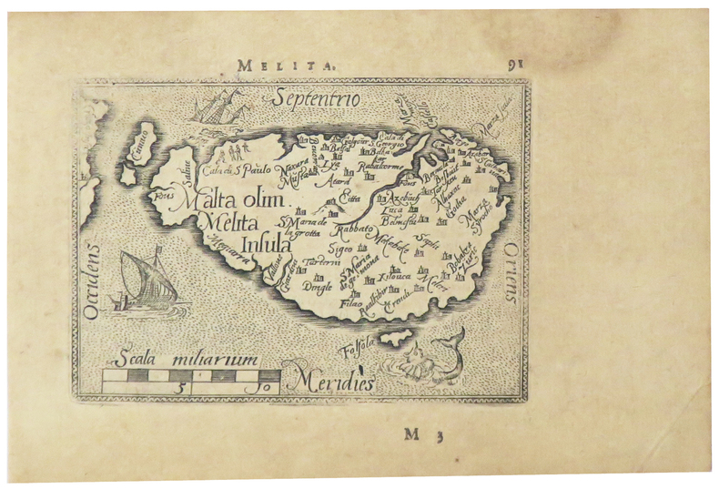
ORTELIUS (Abraham).
[MALTE] Melita.
[Anvers, 1598]. 80 x 107 mm.
Référence libraire : LBW-5386
|
|
|
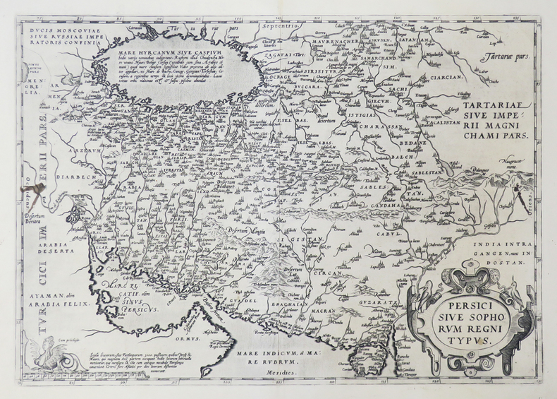
ORTELIUS (Abraham).
[PERSE] Persici sive Sophorum regni typus.
[Anvers, 1592]. 349 x 496 mm.
Référence libraire : LBW0251e
|
|
|
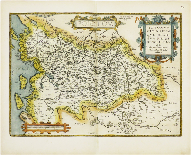
ORTELIUS (Abraham).
[POITOU] Poictou. Pictonum vicinarumque regionum fidiss descriptio.
Anvers, 1579 [1612]. 360 x 504 mm.
Référence libraire : LBW-6675
|
|
|
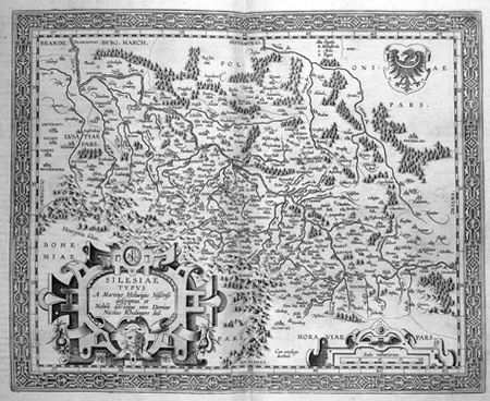
ORTELIUS (Abraham).
[SILESIE] Silesiae typus.
[Anvers, 1603]. 344 x 420 mm.
Référence libraire : LBW02528
|
|
|
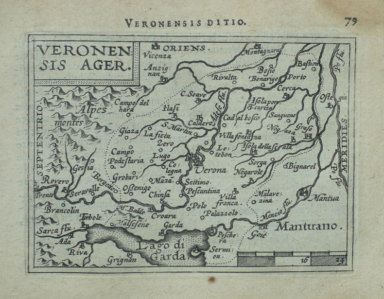
ORTELIUS (Abraham).
[VERONE] Veronensis ager.
[Anvers, 1598]. 82 x 107 mm.
Référence libraire : LBW-1417
|
|
|
ORTELIUS (Abraham).
Africae propriae tabula.
[Anvers, 1608]. 335 x 486 mm.
Référence libraire : LBW01b3a

|
|
|
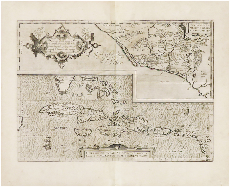
ORTELIUS (Abraham).
Hispaniolae, Cubae, aliarumque insularum circumiacientium, delineatio - Culiacanae, Americae regionis, descriptio.
[Anvers, 1608]. 355 x 498 mm.
Référence libraire : LBW-943
|
|
|
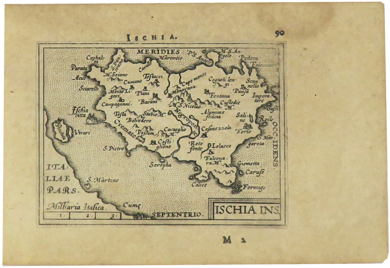
ORTELIUS (Abraham).
Ischia ins.
[Anvers, 1598]. 82 x 106 mm.
Référence libraire : LBW-1405
|
|
|
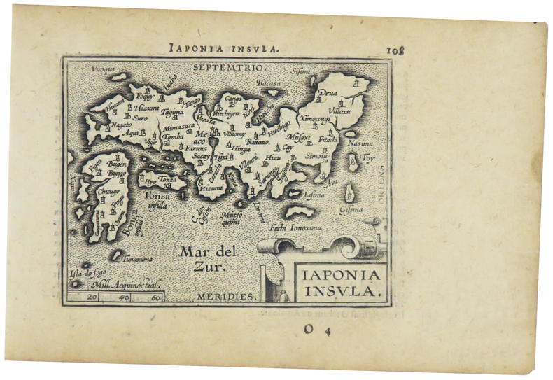
ORTELIUS (Abraham).
Japonia insula.
[Anvers, 1598]. 82 x 102 mm.
Référence libraire : LBW-1424
|
|
|
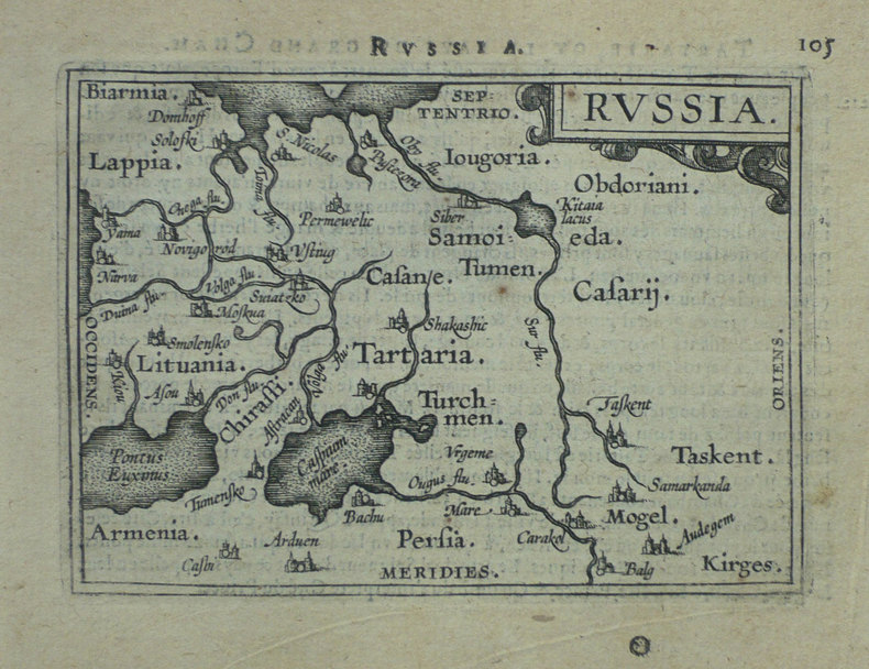
ORTELIUS (Abraham).
Russia.
[Anvers, 1598]. 80 x 106 mm.
Référence libraire : LBW-1431
|
|
|
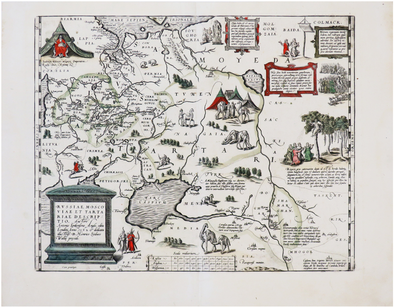
ORTELIUS (Abraham).
Russiæ, Moscoviæ et Tartariæ descriptio.
[Anvers, 1595-1601]. 348 x 442 mm.
Référence libraire : LBW-7252
|
|
|
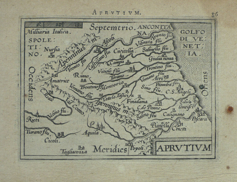
ORTELIUS (Abraham);
[ABRUZZES] Aprutium.
Anvers 1598 80 x 105 mm.
Référence libraire : LBW-1406
|
|
|
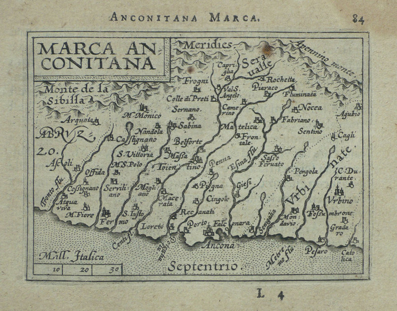
ORTELIUS (Abraham);
[ANCONE] Marca Anconitana.
Anvers 1598 82 x 106 mm.
Référence libraire : LBW-1407
|
|
|
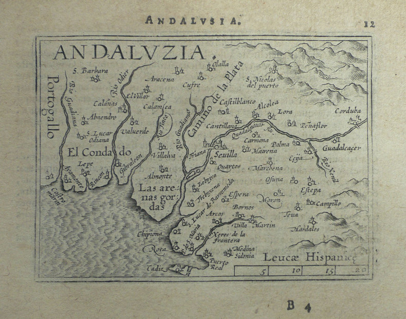
ORTELIUS (Abraham);
[ANDALOUSIE] Andaluzia.
Anvers 1598 80 x 102 mm.
Référence libraire : LBW-1398
|
|
|
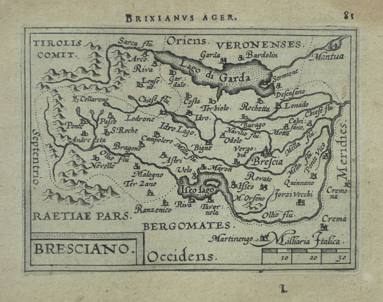
ORTELIUS (Abraham);
[BRESCIA] Bresciano.
Anvers 1598 82 x 106 mm.
Référence libraire : LBW-1419
|
|
|
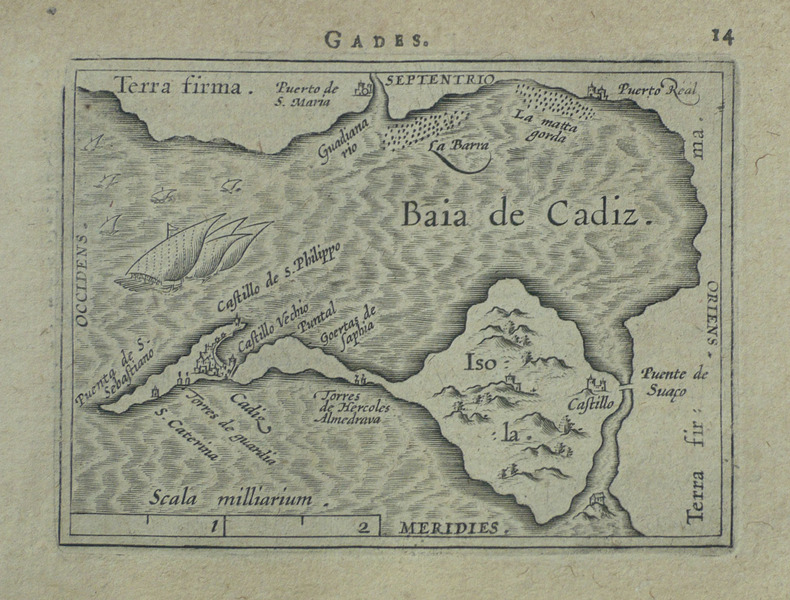
ORTELIUS (Abraham);
[CADIX] Gades.
Anvers 1598 81 x 104 mm.
Référence libraire : LBW-1499
|
|
|
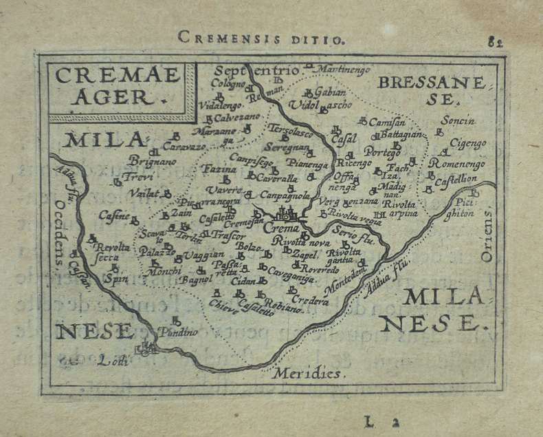
ORTELIUS (Abraham);
[CREMA] Cremae ager.
Anvers 1598 82 x 105 mm.
Référence libraire : LBW-1421
|
|
|
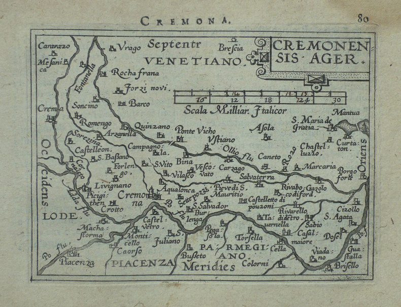
ORTELIUS (Abraham);
[CREMONE] Cremonensis ager.
Anvers 1598 80 x 105 mm.
Référence libraire : LBW-1418
|
|
|
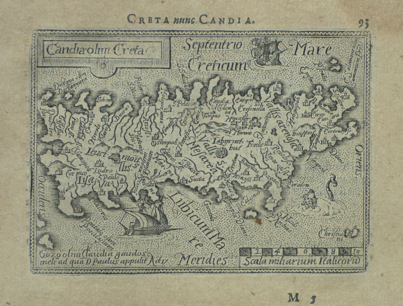
ORTELIUS (Abraham);
[CRETE] Candia olim Creta.
Anvers 1598 82 x 106 mm.
Référence libraire : LBW-1432
|
|
|
ORTELIUS (Abraham);
[CROATIE] Histria.
Anvers 1598 82 x 105 mm.
Référence libraire : LBW-1389

|
|
|
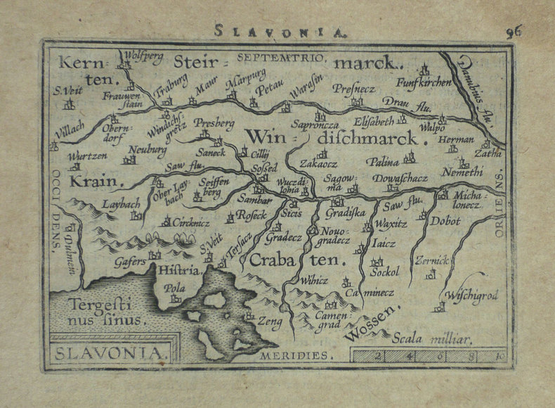
ORTELIUS (Abraham);
[CROATIE] Slavonia.
Anvers 1598 80 x 110 mm.
Référence libraire : LBW-1399
|
|
|
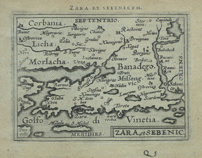
ORTELIUS (Abraham);
[CROATIE] Zara et Sebenico.
Anvers 1598 81 x 105 mm.
Référence libraire : LBW-1430
|
|
|
ORTELIUS (Abraham);
[FLORENCE] Florentinum dominium.
Anvers 1598 81 x 105 mm.
Référence libraire : LBW-1410

|
|
|
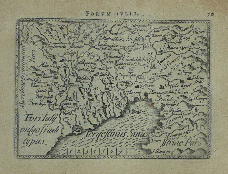
ORTELIUS (Abraham);
[FRIOUL] Fori Iuly vulgo Friuli typus.
Anvers 1598 82 x 105 mm.
Référence libraire : LBW-1422
|
|
|
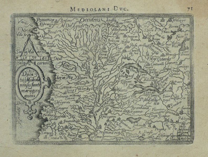
ORTELIUS (Abraham);
[MILANAIS] Ducatus Mediolanensis finitimarumq regionis.
Anvers 1598 83 x 110 mm.
Référence libraire : LBW-1412
|
|
|
ORTELIUS (Abraham);
[ORVIETO] Oropitum.
Anvers 1598 81 x 105 mm.
Référence libraire : LBW-1415

|
|
|
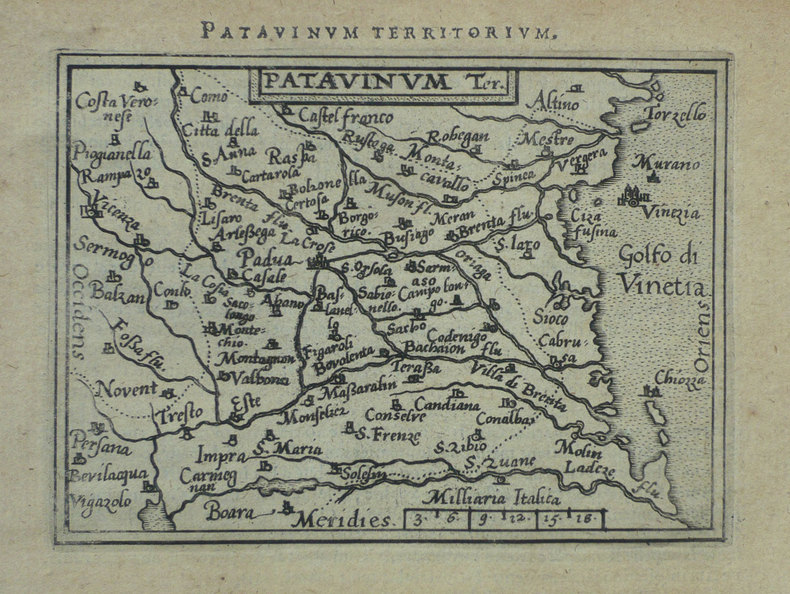
ORTELIUS (Abraham);
[PADOUE] Patavinum.
Anvers 1598 82 x 105 mm.
Référence libraire : LBW-1423
|
|
|
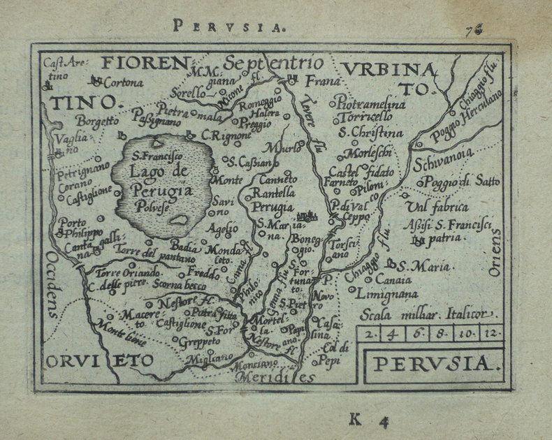
ORTELIUS (Abraham);
[PEROUSE] Perusia.
Anvers 1598 82 x 107 mm.
Référence libraire : LBW-1416
|
|
|
ORTELIUS (Abraham);
[PIEMONT] Pedemontanae vicinorumque regionum auctore Iacobo Castaldo descrip.
Anvers 1595-1609 369 x 494 mm.
Référence libraire : LBW04178

|
|
|
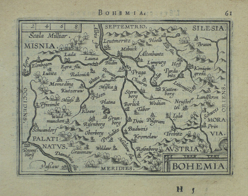
ORTELIUS (Abraham);
[REPUBLIQUE TCHEQUE] Bohemia.
Anvers 1598 81 x 105 mm.
Référence libraire : LBW-1401
|
|
|
ORTELIUS (Abraham);
[ROME] Romanum territorium.
Anvers 1598 81 x 106 mm.
Référence libraire : LBW-1409

|
|
|
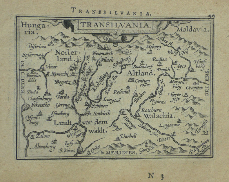
ORTELIUS (Abraham);
[ROUMANIE] Transilvania.
Anvers 1598 80 x 105 mm.
Référence libraire : LBW-1395
|
|
|
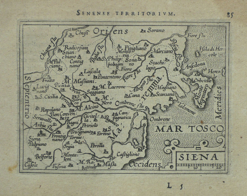
ORTELIUS (Abraham);
[SIENNE] Siena.
Anvers 1598 83 x 106 mm.
Référence libraire : LBW-1420
|
|
|
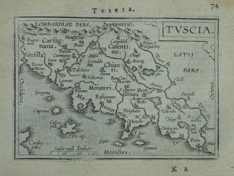
ORTELIUS (Abraham);
[TOSCANE] Tuscia.
Anvers 1598 80 x 109 mm.
Référence libraire : LBW-1411
|
|
|
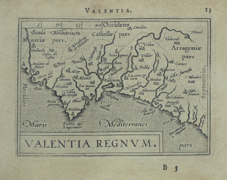
ORTELIUS (Abraham);
[VALENCE] Valentia regnum.
Anvers 1598 81 x 107 mm.
Référence libraire : LBW-1403
|
|
|
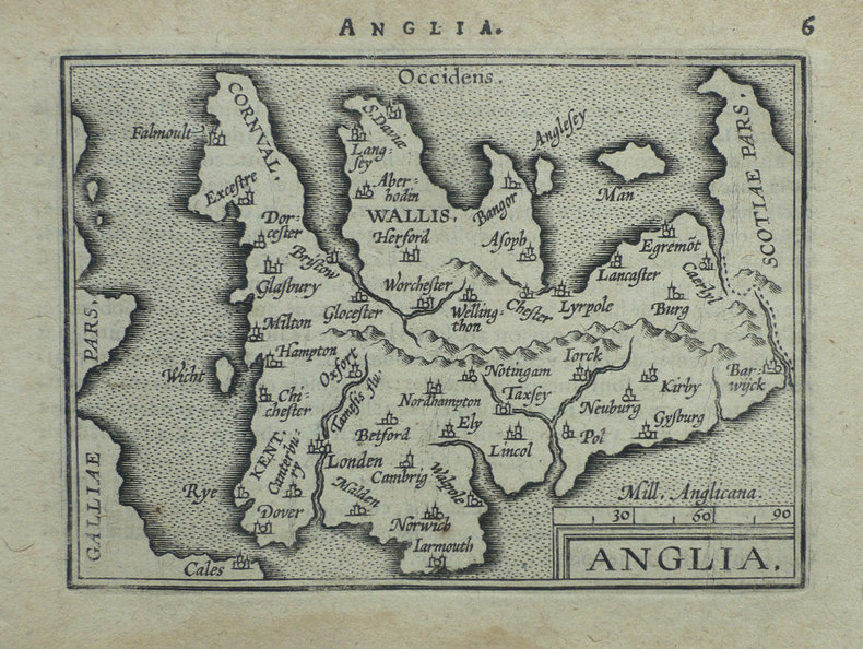
ORTELIUS (Abraham);
Anglia.
Anvers 1598 80 x 104 mm.
Référence libraire : LBW-1375
|
|
|
ORTELIUS (Abraham);
Cyprus insula - Candia olim Creta.
Anvers 1574-1575 363 x 434 mm.
Référence libraire : LBW-589
|
|
|
ORTELIUS (Abraham);
Graeciae universae secundum hodiernum situm neoterica descriptio.
Anvers 1603 365 x 515 mm.
Référence libraire : LBW0394b
|
|
|
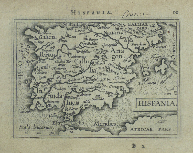
ORTELIUS (Abraham);
Hispania.
Anvers 1598 82 x 107 mm.
Référence libraire : LBW-1404
|
|
|
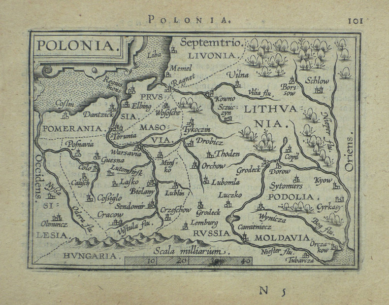
ORTELIUS (Abraham);
Polonia.
Anvers 1598 82 x 108 mm.
Référence libraire : LBW-1390
|
|
|
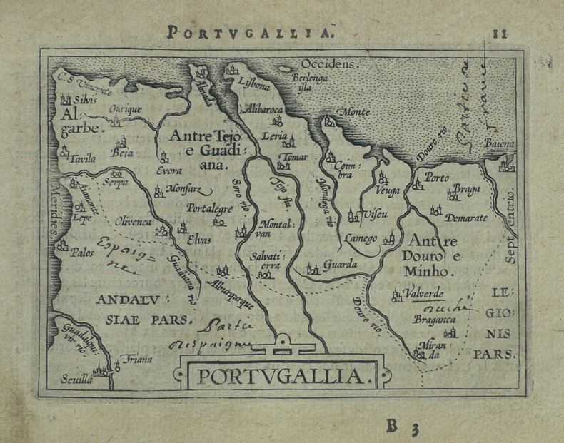
ORTELIUS (Abraham);
Portugallia.
Anvers 1598 81 x 106 mm.
Référence libraire : LBW-1384
|
|
|
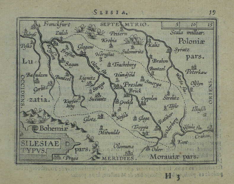
ORTELIUS (Abraham);
Silesiae typus.
Anvers 1598 81 x 106 mm.
Référence libraire : LBW-1391
|
|
|
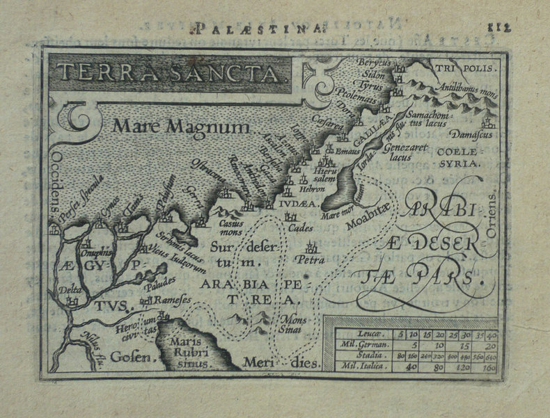
ORTELIUS (Abraham);
Terra sancta.
Anvers 1598 80 x 105 mm.
Référence libraire : LBW-1425
|
|
|
ORTELIUS (Abraham);
Turcicum Imperium.
Anvers 1598 81 x 105 mm.
Référence libraire : LBW-1428

|
|
|
ORTELIUS - GALLE (Haarlem, 1537; Anversa, 12 o 29 Marzo 1612)
Tiipus Orbis Terrarum
Magnifico esemplare di questa rara carta del mondo di Philippe Galle, realizzata per la prima edizione dello Spieghel del Werelt, il primo atlante tascabile pubblicato nel 1577. Questa carta del mondo è una fedele ed accurata riduzione della prima mappa del mondo di Ortelius del 1570, che era la tavola di apertura del suo celebre atlante Theatrum Orbis Terrarum (Shirley, 122; Koeman, Ort 1; Karrow: 1/6, van der Krogt AN: 0001:31A). La lastra incisa da Philippe Galle, reca la data del 1574, sebbene la prima edizione dell'Epitome (secondo il titolo che diventerà comune nei secoli successivi), sia stata pubblicata nel 1577.Questa mappa verrà utilizzata per le sole edizioni dell'Epitome edite dal 1577 al 1585, e sarà poi sostituita da una lastra più piccola, a partire dal 1588. A differenza delle altre carte dell'Epitome, il mappamondo ha un formato più largo. La citazione latina nel margine inferiore, già presente nel modello di Ortelius, è da Cicerone (Tusculanae Disputatianes IV. 1 7. 37) "Quid ei potest videri magnum in rebus humanis, cui aeternitas omnis, totiusque mundi nota sit magnitudo" ovvero "Che cosa, tra le vicende umane, può sembrare grande a colui al quale è nota la grandezza del mondo e l'eternità dell'universo?".La carta del mondo di Ortelius, incisa e firmata da Franciscus Hogenberg, è di fondamentale importanza per la storia della cartografia in quanto costituisce la PRIMA MAPPA DEL MONDO a essere realizzata per un atlante di formato uniforme e non composito, quali gli atlanti del Lafreri. Le fonti cartografiche della carta sono il mappamondo di Mercator del 1569, quello di Gastaldi del 1561 e il portolano dell'Atlantico di Diego Gutierrez. La forma ovale rimanda, invece, ad Appiano e Bordone.Esemplare tratto dalla seconda edizione in lingua francese de Le Miroir du Monde.Le Miroir du Monde è l’edizione in lingua francese in prosa dello Spieghel der Werelt, il primo atlante tascabile pubblicato nel 1577, in lingua olandese, da Philip Galle, con testo in rima curato da Peeter Heyns, e stampato dalla tipografia Plantin. Lo Spieghel der Werelt era una versione ridotta del Theatrum Orbis Terrarum di Ortelius.Le lastre, quasi tutte derivate dal Theatrum, furono disegnate e incise da Philip Galle. Due anni dopo, nel 1579, fu data alle stampe l’edizione in lingua francese in prosa, perché Heyns non aveva avuto il tempo necessario per la resa in versi, col titolo Le Miroir du Monde. Il successo di questa edizione francese, è provato proprio dalla seconda edizione pubblicata a soli 4 anni di distanza, nel 1583.Complessivamente Galle pubblicò 5 edizioni in lingua francese, di cui solo le prime due con il titolo Le Miroir du Monde; a partire dal 1588, e così per le edizioni del 1590 e del 1598, il titolo dell’opera fu modificato in Epitome du thétre du Monde d’Abraham Ortelius, e il nome di Peeter Heyns non figurò più sul frontespizio. Rispetto alla prima edizione del 1579, che conteneva 72 mappe, la seconda edizione fu aumentata di 11 nuove mappe, per un totale di 83 tavole.Dal 1577 al 1598, Galle & Heyns pubblicarono ben 11 edizione, di cui l’ultima – edita nell’anno della morte di Ortelius – conteneva ben 123 mappe. Fine example of Philippe Galle's rare map of the World, engraved for the first edition of his Spieghel del Werelt, the first miniature edition of Ortelius' Theatrum Orbis Terrarum.This map is a neatly-engraved smaller copy of Ortelius' first world map plate, published in 1570, that is the first map of the Theatrum Orbis Terrrarum (Shirley, 122; Koeman, Ort 1; Karrow: 1/6, van der Krogt AN: 0001:31A). The Galle's plate is dated 1574 although the first printing of Galle's atlas did not taken place until 1577. The motto below the map is a quotation from Cicero (Tusculanae Disputatianes IV. 1 7. 37) Quid ei potest videri magnum in rebus humanis, cui aeternitas omnis, totiusque mundi nota sit magnitudo (For what human affairs can seem important to a man who keeps all eternity before his eyes and knows the vastness of the universe?). The worl map published by Galle is larger that the other maps in the atlas. The cartographic sources for the Ortelius world map are: Gerard Mercator's 1569, Gastaldi's 1561 world map and Diego Gutierrez' portolan map of the Atlantic. The oval shape goes back to Apianus and/or Bordonius. The world map by Ortelius, signed by Franciscus Hogenberg, is first one occurring in the first regular atlas the "Theatrum Orbis Terrarum", so the map is of fundamental importance in the history of cartography.This map appeared only in the earliest editions of Ortelius' Epitome, published between 1577-1585 - and from 1588 was replaced by the much smaller Typus Orbis Terrarum.Shirley quotes the rarity fo this map as "S" (Scarce). Map published taken from the second French edition of ‘Le Miroir du Monde’, published by Galle & Heyns in 1583, printed by Plantin. Le Miror du Monde is the French transaltion of the Duch poems Spieghel der Werelt, the first modern pocket-atlas, published by Philip Galle with text by Peeter Heyns in 1577, based on Abraham Ortelius’ Theatrum Orbis Terrarum. The maps were drawn and engraved by Galle. Two years later, in 1579, Galle & Heyns published the first French edition: Heyns translated the Dutch poems into French prose because he did not find time to put them into rhyme. This French edition became very popular and in 1583 an amplified reprint appeared.Galle & Heyns published 5 French edition, two with the title Miroir, and three (1588, 1590, 1598) with the title Epitome du thétre du Monde d’Abraham Ortelius, that appeared from 1588 onwards (Peeter Heyns’ name no longer figures on the title pages of the Antwerp editions).Second French edition of this rare miniature atlas, "enlarged with eleven maps... six are double sized" (Koeman p. 275).Compared to the first edition of 1579, which contained 72 maps, the second edition was increased by 11 new maps, for a total of 83 plates.Between 1577 & 1598 Galle issued 11 editions, all printed by Christopher Plantin. Shirley, 132; Koeman, Ort 47

|
|
|
ORTELIUS Abraham (1528 - 1598)
Aevi Veteris Typus Geographicus
Splendida carta del Mondo Antico pubblicata nel Parergon, l'atlante di Ortelius dedicato alla geografia antica.La mappa presenta i territori conosciuti fino al 1492, all'interno di una proiezione ovale in cui sono rappresentate le fasce climatiche canonizzate da Tolomeo. Ortelius, inoltre, nella realizzazione del planisfero tiene conto del passo di Strabone (II, 5,6) nel quale sostiene che la terra abitata occupi meno della metà dell'emisfero boreale. Pur con queste premesse, il disegno dell'ecumene è moderno, come mostrano i profili del golfo di Guinea, del Madagascar e della penisola indocinese.Il planisfero è circondato da una ricca cornice decorativa nei cui angoli sono contenute le mappe, di formato circolare, dei quattro continenti. Tratta dal Parergon, il primo atlante storico mai pubblicato. Fu inizialmente concepito da Ortelius come appendice del suo Theatrum Orbis Terrarum ma visto il notevole successo di queste carte storiche divenne in seguito un lavoro indipendente e rimase la fonte principale di tutti i lavori simili per tutto il XVII secolo. Come sottolinea Koeman “il Parergon deve essere considerato come lavoro personale di Ortelius. Per quest'opera, infatti, diversamente dal Theatrum, non copiò le mappe di altri cartografi, ma ne disegnò lui stesso di nuove ed originali…prese luoghi, regioni e territori delle civiltà classiche illustrandone e spiegandone la storia, una materia molto vicina al suo cuore. Le mappe e le lastre del Parergon devono essere valutate come le più importanti incisioni che rappresentano il diffuso interesse per la geografia classica nel XVI secolo”. Il Theatrum Orbis Terrarum e che è considerato il primo vero “atlante” moderno. L’opera fu pubblicata in 7 lingue e 36 edizioni, per il quale – nel 1570 - Ortelius ottenne il privilegio, ovvero una sorta di diritto d'autore che impediva ad altri cartografi di pubblicare i propri lavori. Il Theatrum rappresentava il lavoro più avanzato del lavoro della descrizione cartografica. L’Ortelius vi raccolse il sapere geografico e cartografico del suo tempo, proponendo in 147 spettacolari tavole incise l’immagine più fedele del mondo allora conosciuto e, in alcune straordinarie “carte storiche”, regioni e itinerari tratti dalla letteratura, dalla mitologia, dalla tradizione. Incisione su rame, finemente acquarellata, in ottimo stato di conservazione. Esemplare dall'edizione tedesca pubblicata nel 1602. This interesting map presents the regions of the earth that were known in classic times within a large oval projection showing the relative size of the now-known world. The map extends into Asia as far east as Sumatra and south to Madagascar and the Mountains of the Moon in Africa. The climate zones are shown as Zona frigida, temperata, and torrida, with the Zona frigida noted as being uninhabitable. An ornate border surrounds the map and incorporates four small insets: Europe, Asia, Africa and America representing the "modern" world. Map taken from the Parergon, the first historical atlas ever published. It was initially conceived by Ortelius as an appendix to his Theatrum Orbis Terrarum, but given the considerable success of these historical maps it later became an independent work and remained the main source of all similar works throughout the seventeenth century. Koeman wrote: "This atlas of ancient geography must be regarded as a personal work of Ortelius. For this work he did not, as in the Theatrum, copy other people's maps but drew the originals himself... He took many places and regions from the lands of classical civilization to illustrate and clarify their history, a subject very close to his heart... The maps and plates of the Parergon have to be evaluated as the most outstanding engravings depicting the wide-spread interest in classical geography in the 16th century." The Theatrum Orbis Terrarum, which is considered the first true modern "Atlas". The work was published in 7 languages and 36 editions, for which - in 1570 - Ortelius obtained the privilege, a kind of copyright that prevented other cartographers from publishing his works. The Theatrum represented the most advanced work of cartographic description. Ortelius collected in it the geographical and cartographic knowledge of his time, proposing in 147 spectacular engraved plates the most faithful image of the world then known and, in some extraordinary "historical maps", regions and routes taken from literature, mythology, tradition. From the 1602 German edition of the Parergon. Copperplate, with fine colouring, good conditions. Shirley #176; Van den Broecke #186.

|
|
|
ORTELIUS Abraham (1528 - 1598)
Creta Iouis magni, medio iacet insula ponto. Ex conatibus geographicis Abrahami Ortely.
Carta proveniente dall'edizione latina del Parergon sive veteris geographiae aliquot tabulae di Ortelius, raccolta di carte antiche pubblicata per la prima volta nel 1578 come supplemento al Theatrum Orbis Terrarum. Esso era seguito anche da un Nomenclator Ptolemaicus, elenco di tutti i nomi geografici che comparivano nella Geographia di Tolomeo. Questa tavola rappresenta, diversamente orientate ad Est o a Nord, Creta e altre isole dello Ionio, Sardegna e Corsica, ciascuna con margine graduato, longitudine e latitudine, inserite in riquadri in cui è riportato anche un elenco di luoghi dalla posizione sconosciuta. Il retro del foglio, riporta la descrizione in latino delle isole rappresentate. Tratta dal Parergon, il primo atlante storico mai pubblicato. Fu inizialmente concepito da Ortelius come appendice del suo Theatrum Orbis Terrarum ma visto il notevole successo di queste carte storiche divenne in seguito un lavoro indipendente e rimase la fonte principale di tutti i lavori simili per tutto il XVII secolo. Come sottolinea Koeman “il Parergon deve essere considerato come lavoro personale di Ortelius. Per quest'opera, infatti, diversamente dal Theatrum, non copiò le mappe di altri cartografi, ma ne disegnò lui stesso di nuove ed originali…prese luoghi, regioni e territori delle civiltà classiche illustrandone e spiegandone la storia, una materia molto vicina al suo cuore. Le mappe e le lastre del Parergon devono essere valutate come le più importanti incisioni che rappresentano il diffuso interesse per la geografia classica nel XVI secolo”. Il Theatrum Orbis Terrarum e che è considerato il primo vero “atlante” moderno. L’opera fu pubblicata in 7 lingue e 36 edizioni, per il quale – nel 1570 - Ortelius ottenne il privilegio, ovvero una sorta di diritto d'autore che impediva ad altri cartografi di pubblicare i propri lavori. Il Theatrum rappresentava il lavoro più avanzato del lavoro della descrizione cartografica. L’Ortelius vi raccolse il sapere geografico e cartografico del suo tempo, proponendo in 147 spettacolari tavole incise l’immagine più fedele del mondo allora conosciuto e, in alcune straordinarie “carte storiche”, regioni e itinerari tratti dalla letteratura, dalla mitologia, dalla tradizione. Incisione in rame, fine coloritura, in ottimo stato di conservazione. Map of islands of the Mediterranean taken from Ortelius' Parergon; a large map of Crete is at the bottom half of the sheet, with smaller maps of Corsica, the Greek Islands and Sardinia. The Parergon is the first historical atlas ever published. It was initially conceived by Ortelius as an appendix to his Theatrum Orbis Terrarum, but given the considerable success of these historical maps it later became an independent work and remained the main source of all similar works throughout the seventeenth century. Koeman wrote: "This atlas of ancient geography must be regarded as a personal work of Ortelius. For this work he did not, as in the Theatrum, copy other people's maps but drew the originals himself... He took many places and regions from the lands of classical civilization to illustrate and clarify their history, a subject very close to his heart... The maps and plates of the Parergon have to be evaluated as the most outstanding engravings depicting the wide-spread interest in classical geography in the 16th century." The Theatrum Orbis Terrarum, which is considered the first true modern "Atlas". The work was published in 7 languages and 36 editions, for which - in 1570 - Ortelius obtained the privilege, a kind of copyright that prevented other cartographers from publishing his works. The Theatrum represented the most advanced work of cartographic description. Ortelius collected in it the geographical and cartographic knowledge of his time, proposing in 147 spectacular engraved plates the most faithful image of the world then known and, in some extraordinary "historical maps", regions and routes taken from literature, mythology, tradition. Copper engraving, contemporary coloring, in good condition. Van den Broecke 217; Zacharakis, Greece 1621.

|
|
|
ORTELIUS Abraham (1528 - 1598)
Gallia Vetus, Ad Iulij Caesaris commentaria . . . 1590
Bella carta dell'antica regione della Gallia, tratta dal Parergon, il primo atlante storico mai pubblicato. Fu inizialmente concepito da Ortelius come appendice del suo Theatrum Orbis Terrarum ma visto il notevole successo di queste carte storiche divenne in seguito un lavoro indipendente e rimase la fonte principale di tutti i lavori simili per tutto il XVII secolo. Come sottolinea Koeman “il Parergon deve essere considerato come lavoro personale di Ortelius. Per quest'opera, infatti, diversamente dal Theatrum, non copiò le mappe di altri cartografi, ma ne disegnò lui stesso di nuove ed originali…prese luoghi, regioni e territori delle civiltà classiche illustrandone e spiegandone la storia, una materia molto vicina al suo cuore. Le mappe e le lastre del Parergon devono essere valutate come le più importanti incisioni che rappresentano il diffuso interesse per la geografia classica nel XVI secolo”. Il Theatrum Orbis Terrarum e che è considerato il primo vero “atlante” moderno. L’opera fu pubblicata in 7 lingue e 36 edizioni, per il quale – nel 1570 - Ortelius ottenne il privilegio, ovvero una sorta di diritto d'autore che impediva ad altri cartografi di pubblicare i propri lavori. Il Theatrum rappresentava il lavoro più avanzato del lavoro della descrizione cartografica. L’Ortelius vi raccolse il sapere geografico e cartografico del suo tempo, proponendo in 147 spettacolari tavole incise l’immagine più fedele del mondo allora conosciuto e, in alcune straordinarie “carte storiche”, regioni e itinerari tratti dalla letteratura, dalla mitologia, dalla tradizione. Incisione in rame, finemente colorata a mano in epoca, in buono stato di conservazione. First state of this map of ancient France, which Ortelius compiled from military information in Caesar's "De Bello Gallico". The map contains less geographical detail than the similar map "Galliae Veteris Typus". Large strapwork title, dedication and scale of miles cartouches, a elaborately engraved border and panels at sides with the names of famous people. Map taken from the Parergon, the first historical atlas ever published. It was initially conceived by Ortelius as an appendix to his Theatrum Orbis Terrarum, but given the considerable success of these historical maps it later became an independent work and remained the main source of all similar works throughout the seventeenth century. Koeman wrote: "This atlas of ancient geography must be regarded as a personal work of Ortelius. For this work he did not, as in the Theatrum, copy other people's maps but drew the originals himself... He took many places and regions from the lands of classical civilization to illustrate and clarify their history, a subject very close to his heart... The maps and plates of the Parergon have to be evaluated as the most outstanding engravings depicting the wide-spread interest in classical geography in the 16th century." The Theatrum Orbis Terrarum, which is considered the first true modern "Atlas". The work was published in 7 languages and 36 editions, for which - in 1570 - Ortelius obtained the privilege, a kind of copyright that prevented other cartographers from publishing his works. The Theatrum represented the most advanced work of cartographic description. Ortelius collected in it the geographical and cartographic knowledge of his time, proposing in 147 spectacular engraved plates the most faithful image of the world then known and, in some extraordinary "historical maps", regions and routes taken from literature, mythology, tradition. Copperplate with fine original hand colouring, very good condition. Van den Broecke 195.

|
|
|
ORTELIUS Abraham (1528 - 1598)
Latium
Bell'esemplare della mappa di Ortelius del Lazio, tratta dal Parergon di Ortelius, un atlante che rappresenta il mondo antico. Il Parergon fu generalmente pubblicato come appendice all'opera magna di Ortelius, il Theatrum Orbis Terrarum, che è considerato il primo atlante moderno. Tuttavia, il Parergon fu anche pubblicato come atlante separato in alcune occasioni, tra cui nel 1595 e nel 1624. Orientata verso nord, questa mappa si estende dal Mar Tirreno (Maris Tyrrheni) a sud fino alla regione dell'Umbria a nord, mostrando l'intera regione del Lazio così come parti delle regioni Toscana (Tusciae pars) e Campania (Campaniae pars). Le città sono rappresentate da edifici disegnati individualmente, nel tipico stile ortelico. Tre bellissimi cartigli adornano la mappa. Nell'angolo nord-est, il cartiglio del titolo è particolarmente ornato. Un cartiglio più semplice in Toscana dedica la mappa allo storico e patrizio Marcus Velser Augustanus. Il terzo cartiglio contiene un inserto della mappa del Monte Circeo (Mons Circaeus), e una nota indica che questa rappresentazione è stata fatta da Angelo Breventanus. Questo cartiglio contiene anche una semplice rosa dei venti, poiché il suo orientamento è diverso da quello della mappa più grande. Alcuni dettagli in questa mappa enfatizzano la storia e la mitologia associate a questa regione. Nel Mar Tirreno (Maris Tyrrheni), una nave naviga completa di rematori, soldati e due armi d'artiglieria, ricordando allo spettatore la potenza militare dell'Impero Romano. L'antica casa della maga Circe, che appare molto nell'Odissea di Omero, è nota a Circaeium. C'è anche una piccola descrizione al Lago Fucino (Fucinus Lacus), che indica che il lago contiene pesci con otto pinne, secondo Plinio. Il Parergon fu un progetto di interesse personale e l'opera che Ortelius stesso considerava il suo più grande risultato. Aveva un profondo interesse per l'antichità classica che lo spinse a creare le mappe del Parergon, e la quantità di tempo e di dettagli che mise in ogni mappa è chiaramente evidente. Ortelius disegnò a mano ogni mappa del Parergon, il che richiese una notevole abilità e conoscenza della storia e della geografia dell'area. È considerato il primo atlante storico. Acquaforte, finemente colorata a mano, buono stato di conservazione. Bibliografia Marcel P. Van den Broecke, Ortelius, n. 209. Fine example of Ortelius' map of the region of Latium from Ortelius' Parergon, an atlas depicting the ancient world. The Parergon was generally published as an appendix to Ortelius’ magnum opus, the Theatrum Orbis Terrarum, which is considered the first modern atlas. However, the Parergon was also published as a separate atlas on a few occasions, including in 1595 and 1624. Oriented northward, this map extends from the Tyrrhenian Sea (Maris Tyrrheni) in the south to the region of Umbria in the north, showing the entire region of Latium as well as parts of the regions of Tuscany (Tusciae pars) and Campania (Campaniae pars). Cities are depicted by individually drawn buildings, in typical Ortelian style. The natural features of the map are also neatly rendered. Mountain ranges and winding rivers cross the territory and trees dot the map at various points. The Fucine Lake (Fucinus Lacus) as well as the sea to the south of the Italian coast are filled in with careful stippling. Along the southern coast of Latium and Campania, Ortelius has added marshlands to give the viewer a better sense of the area’s geography. Three beautiful cartouches adorn the map. In the northeast corner, the title cartouche is particularly ornate. A simpler cartouche in Tuscany dedicates the map to the historian and patrician Marcus Velser Augustanus. The third cartouche contains an inset map of Mount Circeo (Mons Circaeus), and a note indicates that this depiction was done by Angelo Breventanus. This cartouche also contains a simple compass rose, as its orientation is different from the larger map. The strapwork cartouches employ texture and shading which give them a vivid appearance. Certain details in this map emphasize the history and mythology associated with this region. In the Tyrrhenian Sea (Maris Tyrrheni), a ship sails complete with oarsmen, soldiers, and two artillery weapons, reminding the viewer of the Roman Empire’s military might. The ancient home of the sorceress Circe, who features heavily in Homer’s Odyssey, is noted at Circaeium. There is also a small description at the Fucine Lake (Fucinus Lacus), indicating that the lake contains eight-finned fish, according to Pliny. Both myths and real historical figures are well represented, which makes this map particularly interesting among some of the others in the Parergon. Although best known for his world atlas, the Theatrum Orbis Terrarum, the Parergon was a project of personal interest and the work that Ortelius himself considered his greatest achievement. He had a deep interest in classical antiquity which spurred him to create the Parergon maps, and the amount of time and detail he put into each map is clearly evident. Ortelius hand drew each map of the Parergon, which required considerable skill and knowledge of the area’s history and geography. It is considered the first historical atlas. Copperplate with fine later hand colour, very good condition. Reference Marcel P. Van den Broecke, Ortelius, n. 209.

|
|
|
 Recevoir par e-mail
 Télécharger en PDF
 Flux RSS


