|
Barbra Crossette; Cover Design Krystyna Skalski Illustrator; Cover Illustrations Steven Guarnaccia Illustrator; Maps by Donald P
America's Wonderful Little Hotels and Inns 1984 Eastern Region including Puerto Rico and Eastern Canada
Congdon & Weed 1984-01-01. Fourth Edition. Paperback. Very Good. Softcover showing minor scuffing. Spine is mostly uncreased. Edges and corners showing minor wear. Pages are unmarked or folded. Congdon & Weed paperback
書籍販売業者の参照番号
: 200220-c6-rw-0020
|
|
|
Barclay Maps
1973-74 Map and Street Guide Riverside California MAP
Barclay Maps 1973. Map - VG - Map is clean with only light wear. Map. Very Good. Barclay Maps Hardcover
書籍販売業者の参照番号
: 228110
|
|
|
Barker A. J. & 58 B/W Photos 33 Maps
The Bastard War The Mesopotamian Compaign of 1914-1918
New York: Dial Press. Near Fine in Very Good dust jacket. 1967. Hardcover. A bit of edge soil jakcet faded with some wear & chips on extremities; 9.10 X 6.50 X 1.60 inches . Dial Press hardcover
書籍販売業者の参照番号
: 42619
|
|
|
BARKER Ronnie
Pennyworth of Art : the Green album -- his own collection of picture Postcards.
The Herbert press, 1986. Grand in-8 carré relié, avec jaquette imprimée en couleurs, 96 pages, richement illustré en couleurs, très bon état. /// the Herbert Press, London, 1986. Hardcover. État : Very Good. Etat de la jaquette : Very Good. Photographic (illustrateur). 1st Edition. 550 g; 96 pages of postcards with an introduction and attendant commentary on each card. Colour illustrated dust wrapper is very slightly faded on the spine section, and the Green papered boards are slightly rubbed on the bottom edge.
書籍販売業者の参照番号
: 18587

|
|
|
Barker, Felix
London from the Air
No marks or inscriptions. A very clean crisp very tight copy with bright unmarked boards and no bumping to corners. Dust jacket not price clipped or marked or torn or creased with light traces of storage. 144pp.

|
|
|
Barnes, Jeremy
The Pictorial History of the American Civil War
208 pages including index. From the first firing of guns at Fort Sumter to the ultimate surrender of the South, richly illustrated with many contemporary engravings and rare photographs as well as many colour illustrations and maps. A must for every Civil War Buff. Clean and unmarked. Very light wear. Gorgeous copy of this handsome work. Book
|
|
|
Barnett A. Doak; End Paper Maps Illustrator
COMMUNIST CHINA AND ASIA CHallenge to American Policy. Council on Foreign Affairs Study
Harper & Brothers 1960-01-01. Hardcover. Very Good. Hardcover. Very Good in Very Good dust jacket. Clean tight. Name inside. Harper & Brothers hardcover
書籍販売業者の参照番号
: UT1513415

|
|
|
Barnett's Maps
Bedford Street Plan with Index with Road Map of Bedfordshire and Plan of Car Parks & One-Way Streets
Barking: G.I. Barnett & Son. No date 1970s folded map with some red ink hi -liting. . Good. Paperback. G.I. Barnett & Son paperback
書籍販売業者の参照番号
: 153011
|
|
|
BARNEVILLE
Carte couleurs au 1/100 000?. Feuille VIII-11. Mise ? jour 1923.
Une feuille 57x45 cm.
|
|
|
Baron, Stanley
The Road to Rome
No marks or inscriptions. A very clean very tight copy with bright unmarked boards and no bumping to corners. Dust jacket not price clipped or marked, torn or creased with a little rubbing to bottom of spine. 307pp. The author follows a route from Boulogne by way of Reims, Colmar, Lucerne, the St Gotthard Pass, Milan, Lake Maggiore, Cremona, Ravenna, Florence and finally Rome where he continues his tour.

|
|
|
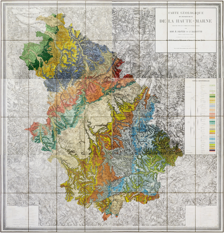
BAROTTE (Jules) & ROYER (Ernest).
Carte géologique du département de la Haute-Marne, exécutée sous les auspices du Conseil Général par MM. E. Royer et J. Barotte, membres de la Société Géologique de France, et publiée de 1859 à 1863 sous l'administration de MM. Girard de Villesaison et Rostan d'Ancezune, Préfets.
Nancy, Wiener Aîné Fils, 1859-1863. En six feuilles coupées en sections et montées sur toile brune, pouvant être jointes pour former une carte d'environ 1,72 x 1,63 m ; étiquette de l'éditeur Wiener Aîné Fils, papetier à Nancy, au dos de chaque carte ; sous emboîtage in-4 de papier marbré de l'époque.
書籍販売業者の参照番号
: LBW-6191
|
|
|
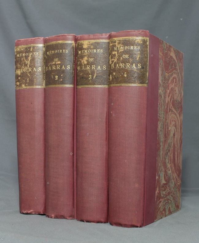
BARRAS Paul; DURUY George (intro):
Mémoires de Barras, membre du directoire.
Paris, Lib. Hachette, 1895-1896. 4 volumes in-8 de LXXXIII-372 / XVI-543 / XXXVI-526 et XXXII-548 pages, demi-percaline bordeaux, dos lisses, étiquettes de titre brunes, un brin frottées, couvertures conservées.
書籍販売業者の参照番号
: 1723
|
|
|
BARRERE, Henry ; ANDRIVEAU-GOUJON
Empire Ottoman [ Carte de l'Asie Mineure - 1904 ]
Carte entoilée en couleur au format 94 x 68 cm, échelle 1 : 3500000, Maison Andriveau-Goujon, Henry Barrère, Paris, 1904 (mention rev. 1904), carte n° 15, atlas usuel n° 21 ; atlas universel n° 34, gravé : le trait par Smith, la topographie par Gérin, les Ecritures par Rousset, les Eaux par Mme Fontaine
書籍販売業者の参照番号
: 26332
|
|
|
BARRERE, Henry ; ANDRIVEAU-GOUJON
Empire Ottoman [ Carte de l'Asie Mineure - 1904 ]
Carte entoilée en couleur au format 94 x 68 cm, échelle 1 : 3500000, Maison Andriveau-Goujon, Henry Barrère, Paris, 1904 (mention rev. 1904), carte n° 15, atlas usuel n° 21 ; atlas universel n° 34, gravé : le trait par Smith, la topographie par Gérin, les Ecritures par Rousset, les Eaux par Mme Fontaine Belle grande carte entoilée de l'Empire ottoman (petites usures aux pliures, une petite annotation marginale). Français

|
|
|
Barrett, Betty and Power, Frances
The Golden Book of Dublin
No inscriptions or marks. No creasing to covers or to spine. A very clean crisp tight copy with bright unmarked boards, very slight traces of handling and no bumping to corners. 64pp. A brief history of Dublin, a guide and map to the city.

|
|
|
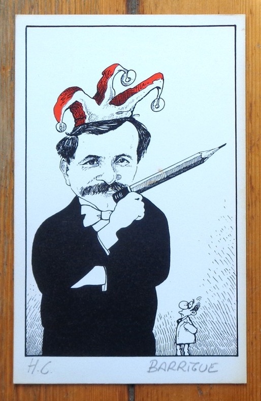
Barrigue:
[Autoportrait au crayon].
Sérigraphie en deux tons, au format 12,5 x 20 cm. Très légèrement jaunie en bord.
書籍販売業者の参照番号
: 6306
|
|
|
Barrigue:
Etiquette Dôle de Sierre 1982.
Etiquette et bandeau pour une Dôle de Sierre Tavelli.
書籍販売業者の参照番号
: 1899

|
|
|
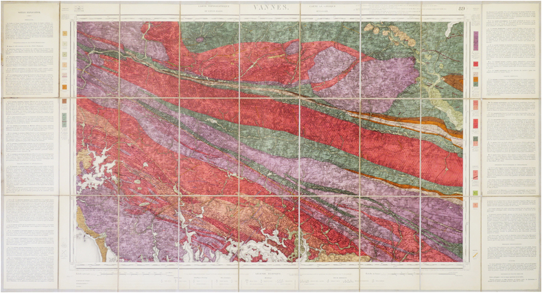
BARROIS (Charles).
[VANNES/GÉOLOGIE] Carte géologique détaillée. Vannes. Feuille n°89.
Paris, Dépôt de la Guerre, 1890. En 27 sections montées sur toile et repliées, formant une carte de 0,61 x 1,14 m ; étiquette au dos de la carte de la Maison Andriveau-Goujon Henry Barrère, Éditeur Géographe.
書籍販売業者の参照番号
: LBW-7857
|
|
|
Barron Roderick
Decorative Maps
<p>Folio 28X38cm 8p. 40 color plates ill covers</p> Bracken Books, poster art series paperback
書籍販売業者の参照番号
: biblio638 ISBN : 1851702989 9781851702985
|
|
|
Barron, Roderick M
The World Displayed - Rare, fine & decorative Antique Maps & Globes of the World & its regions (Summer 2003)
Sevenoaks, Kent, Roderick M.Barron, Antique Map Specialist, 2003. 190 S.mit zahlreichen überwiegend farbigen Abbildungen, Tafeln (Karten); Original-Karton; 8°. Sehr gutes Exemplar. Verzeichnet 215 Nummern.
書籍販売業者の参照番号
: D12840
|
|
|
BARROW, John.
Nouveau voyage dans la partie méridionale de l'Afrique....
Dentu, Imprimeur - Libraire, Paris, 1806, 2 volumes in-8 , x-310pp. ,2ffnch.-312pp. ,illustré de 8 cartes dépliantes , relié plein cuir époque , dos lisse avec pièce de titre rouge et tomaison noire , tranches mouchetées bleues , coupes et coins usés , début de fentes , rares rousseurs , frottements.
書籍販売業者の参照番号
: PHO-1285
|
|
|
Barry Gifford.
An Unfortunate Woman. ( Dédicacé par Barry Gifford sur carte postale )
Creative Arts Book Compagny / San Francisco 1984. In-8 cartonnage éditeur de 172 pages au format 14,3 x 22,5 cm. Couverture avec titre imprimé. Dos rond. Plats et intérieur faris. Complet de la belle jaquette illustrée, avec petits frottis aux coins et minuscule déchirure en haut du 1er plat. Edition originale. Exemplaire du service de presse accompagné du prière d'insérer et du carton hommage de l'éditeur ainsi que d'une carte postale, représentant un visage d'Indien Shaman, ornée d'une superbe dédicace autographe, de 13 lignes, signée, et datée de l'auteur. Celles-ci sont très rares.
書籍販売業者の参照番号
: 8187

|
|
|
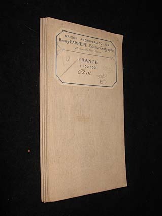
Barrère Henry
France 1 : 100.000. Brest
Maison Andriveau-Goujon Carte 1913 In-8 (12.5x23.5 cm), carte pliée, carte du Finistère reproduite en couleurs ; traces sur les plats, assez bon état. Livraison a domicile (La Poste) ou en Mondial Relay sur simple demande.
書籍販売業者の参照番号
: jj5340
|
|
|
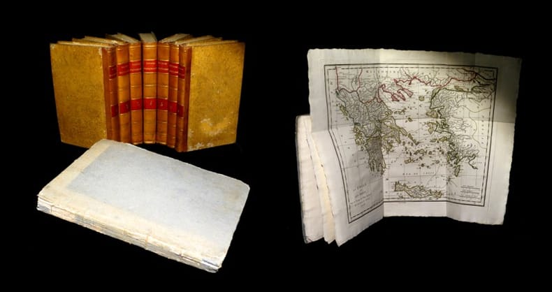
BARTHELEMY (Jean-Jacques).
Voyage du jeune Anacharsis en Grèce & Recueil de cartes géographiques, plans, vues, médailles de l'ancienne Grèce.
A Paris, chez E. A. Lequien / de l'Imprimerie de P. Didot l'Aîné, 1822 - A Paris, chez de Bure, 1839 (pour le volume d'Atlas). 7 vol. de texte au format in-8 (225 x 141 mm) de 1 f. bl., 2 ff. n.fol., 1 frontispice gravé n.fol., 451 pp. et 1 f. bl. ; 1 f. bl., 2 ff. n.fol., 488 pp. et 1 f. bl. ; 1 f. bl., 2 ff. n.fol., 462 pp., 1 f. n.fol. et 1 f. bl. ; 1 f. bl., 2 ff. n.fol., 474 pp., 1 f. n.fol. et 1 f. bl. ; 1 f. bl., 2 ff. n.fol., 466 pp., 1 f. n.fol. et 1 f. bl. ; 1 f. bl., 2 ff. n.fol., 423 pp., 1 f. n.fol. et 1 f. bl. ; 1 f. bl., 2 ff. n.fol., 438 pp., 1 f. n.fol. et 1 f. bl. 1 vol. d'Atlas au format pt in-4 (282 x 223 mm) de xlii pp et 31 planches gravées, sous couverture d'attente de l'époque de plein cartonnage gris-perle.
書籍販売業者の参照番号
: 19077
|
|
|
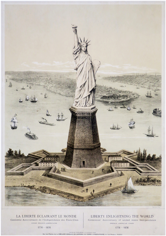
BARTHOLDI (Frédéric Auguste) & CHÉRET (Jules).
La Liberté éclairant le Monde. Centième anniversaire de l'Indépendance des États-Unis. Union Franco-Américaine. 1776-1876. - Liberty enlightning the World. Centennial anniversary of United States Independance. French-American Union. 1776-1876. Bartholdi scup.t. Imprimé par JULES CHÉRET, 18, rue Brunel, PARIS, Sur les Pierres de la COMPAGNIE GÉNÉRALE DES CARRIÈRES DE PIERRES LITHOGRAPHIQUES, 3, rue Rossini, PARIS.
[entre 1875 et 1876]. 685 x 478 mm.
書籍販売業者の参照番号
: LBW-6827
|
|
|
Bartholemew Maps
'Bartholemew''s Contoured Road Map of the British Isles'
Edinburgh: John Bartholemew & Sons 1961. Folding color map scale 1: 1000000. Good Plus unmarked bright w a few small tears at the fold points one clean 7-inch corner tear some tape scars at top. All tears easily repairable. A vintage color-contoured view of Britain. 35 x 40. Scarce. <br/><br/> John Bartholemew & Sons unknown
書籍販売業者の参照番号
: 4556
|
|
|
Bartholomew J. G. & Herbertson A. J. & Buchan Editor
ATLAS OF METEOROLOGY
Edinburgh: The Royal Geography Society 1899. "A Series of Over Four Hundred Maps - prepared by J. G. Bartholomew and A. J. Herbertson and edited by Alex Buchan . Under the Patronage of the Royal Geographical Society Prepared by the Edinburgh Geographical Institute" Bartholomew's Physical Atlas - Volume III. Fine colour maps throughout. A very good copy of this impressive atlas. Original blue cloth binding with glazed blue-black pebbled cloth to the spine and corners gilt lettering. Binding very good with a little general wear only and slight rubbing to extremities and joints. Top edge gilt. Contents clean and tight no inscriptions no foxing. A very good to fine copy. First Edition. Hardcover. Very Good. Folio. The Royal Geography Society Hardcover
書籍販売業者の参照番号
: 007362
|
|
|
Bartholomew Maps
Bartholomew's Half-Inch Contoured Maps Sheet 8 Salisbury Plain by Bartholomew Maps
Bartholomew Maps. Paperback. Acceptable. Binding: Paperback ---Publisher: Bartholomew Maps---Date: 1962 ---Edition: ---Pages: ---Condition: Fair ---DJ Condition: ---Description: All of the pages are tightly bound no stamps or inscriptions the only flaws are some scuffs and light creases to the covers. and a couple of short routes have been marked on the map in blue biro. MOST OF OUR BOOKS ARE SHIPPED WITHIN 1 WORKING DAY OF PURCHASE. . BUY WITH CONFIDENCE - WE UPLOAD A SELECTION OF HIGH QUALITY PHOTOGRAPHS WITH EACH LISTING HOWEVER IF NOT ALREADY PRESENT PHOTOGRAPHS OF ANY OF OUR TITLES CAN BE PROVIDED BY REQUEST VIA E-MAIL. Bartholomew Maps paperback
書籍販売業者の参照番号
: SKU1011441

|
|
|
Bartholomew's Maps
Bartholomew's Revised "Half-Inch" Contoured Maps - Sheet 15 - Herts and Bucks
Bartholomew's Maps 1930-01-01. Paperback. Good. Binding: Paperback ---Publisher: Bartholomew's Maps ---Date: None Stated ---Edition: ---Pages: ---Condition: Good ---DJ Condition: --- Description: All of the pages are unmarked no stamps or inscriptions the only flaws are a couple of small rips to the outer edges of the map and a couple of small creases to the covers. . MOST OF OUR BOOKS ARE SHIPPED WITHIN 1 WORKING DAY OF PURCHASE. If not already present high quality photographs of any of our titles can be provided by request via e-mail. Bartholomew's Maps paperback
書籍販売業者の参照番号
: SKU1003773
|
|
|
Bartholomew
Bartholomew's Revised ''half -Inch'' Contoured Maps Cambridge Great Britain Sheet 20 Paper
Edinburgh: John Bartholomew 1948. Revised. Paperback. Very Good. Clean colour fold out map mounted on paper. Sheet 20 in the Bartholomew's series. Blue cover. Minor wear . Some inked rourtes on inside cover. Good for its age <br/><br/> John Bartholomew paperback
書籍販売業者の参照番号
: 2269
|
|
|
Bartholomew
Bartholomew's Revised ''half -Inch'' Contoured Maps Warwickshire Great Britain Sheet 19
Edinburgh: John Bartholomew 1948. Revised. Paperback. Very Good. Clean colour fold out map mounted on paper. Sheet 29 in the Bartholomew's series. Blue cover. Minor wear . Some inked rourtes on inside cover. Good for its age <br/><br/> John Bartholomew paperback
書籍販売業者の参照番号
: 2270
|
|
|
Bartholomew
Bartholomew's Revised Half Inch Contoured Map Of Great Britain - Sheet 21 - Suffolk
Edinburgh: John Bartholomew 1948. Revised. Paperback. Very Good. Clean colour fold out map mounted on paper. Sheet 21 in the Bartholomew's series. Blue cover. Minor wear and tears including a couple slightly larger ones which are repairable if wished Good for its age <br/><br/> John Bartholomew paperback
書籍販売業者の参照番号
: 2268
|
|
|
Bartholomew Maps
London Westminster to the City Map - 9 Inches to the Mile by Bartholomew Maps
Bartholomew Maps. Paperback. Good. Binding: Paperback ---Publisher: Bartholomew Maps ---Date: 1963 ---Edition: ---Pages: ---Condition: Good ---DJ Condition: --- Description: The map is unmarked no stamps or inscriptions the only flaws are a couple of minor scuffs to the covers. . MOST OF OUR BOOKS ARE SHIPPED WITHIN 1 WORKING DAY OF PURCHASE. If not already present high quality photographs of any of our titles can be provided by request via e-mail. Bartholomew Maps paperback
書籍販売業者の参照番号
: SKU1005991
|
|
|
Bartholomew John G maps
The Times Comprehensive Atlas of the World. 12th Edition. 2008
London: The Times Book Group. VG: in very good condition with slipcase. 2008. 12th Edition reprint. Illustrated hardback laminated board cover. 460mm x 320mm 18" x 13". 67pp 224pp plates. Colour maps. . The Times Book Group hardcover
書籍販売業者の参照番号
: ta-008 ISBN : 0007801505 9780007801503

|
|
|
Bartholomew John G maps
The Times Comprehensive Atlas of the World. 10th Edition. 2001
London: The Times Book Group. VG: in very good condition with dust jacket and silver/black slipcase. Jacket and slip case lightly rubbed. 2001. 10th Edition reprint. Black hardback cloth cover. 460mm x 320mm 18" x 13". 124 plates; 220pp. 320 colour plates. . The Times Book Group hardcover
書籍販売業者の参照番号
: ta-001 ISBN : 0723007926 9780723007920

|
|
|
Bartholomew
Bartholomew's Quarter Inch Map of Ireland : Sheet 4 - Cork and Killarney
No marks or inscriptions. Two secitions slightly sunned. A little tearing along most exposed vertical fold. Some exposure of the linen but still intact along some other folds. 1pp. Folded linen-backed vintage map of Cork and Killarney opens up to 23 x 33 inches. Undated ca 1950s. Compass north bearing date 1948.
|
|
|
Bartholomew
Bartholomew's Quarter Inch Map of Ireland : Sheet 5 - Galway - Mayo
No marks or inscriptions. A little very slightl sunning. Intact map with no tears. 1pp. Folded linen-backed vintage map of Galway and Mayo opens up to 23 x 33 inches. Undated ca 1950s. Compass north bearing date 1951.
|
|
|
Bartholomew
World travel map Israel with Jordan. Scale 1:350000.
Bartholomew, Edinburgh 1971. Farbige gefaltete Karte. Ca. 66 x 86 cm (bxh). Geringe Gebrsp.
書籍販売業者の参照番号
: 10980
|
|
|
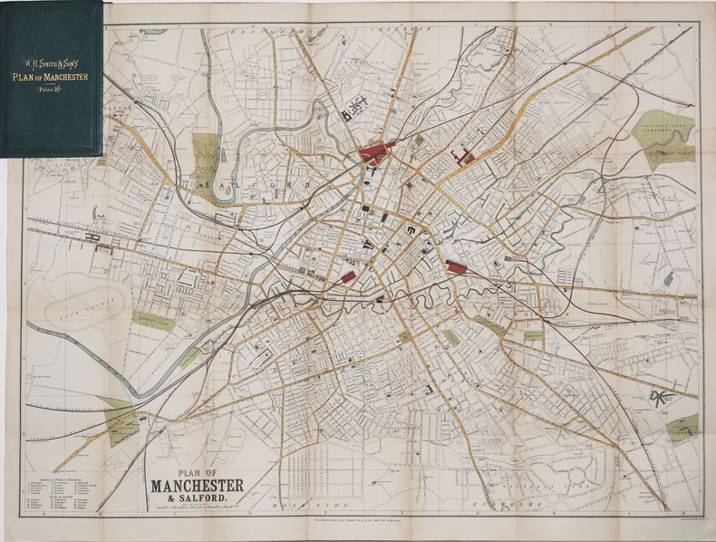
BARTHOLOMEW (John).
[MANCHESTER] Plan of Manchester & Salford.
[circa 1890]. 500 x 680 mm ; replié et monté dans une reliure de percaline verte de l'éditeur W.H. Smith & Sons contenant l'index des rues (16,2 x 10,5 cm).
書籍販売業者の参照番号
: LBW-3270
|
|
|
BARTHOLOMEW'S RAILWAY MAP.
Bartholomew's Railway Map of the British Isles showing the New Grouping. Each Group distinuished by a Separate Colour. [Scale Nineteen Miles to One Inch.] BRIGHT, CLEAN COPY
8vo., folding coloured map on cloth measuring 34.5 x 29 inches (approx. 88 x 74 cms) folding in 24 panels to 9.5 inches (approx. 23 x 13 cms); wrappers lettered in red and black, certain folds neatly reinforced, some mild age-soiling and rubbing else a very good, bright, clean copy. VERY SCARCE IN THIS CONDITION.
|
|
|
BARTHÉLEMY (J.E.).
Plan géométrique (en deux feuilles) des bois dépendants du domaine de Tigery appartenants à Madame de Clermont-Tonnerre. Dressé par J.E. Barthélemy, géomètre à Corbeil, d'après les réarpentages successifs faits depuis 1843 inclusivement (à l'exception de l'année 1851).
1864. In-folio ; demi-percaline noire, dos lisse muet, pièce de titre de maroquin rouge sur le premier plat (reliure de l'époque).
書籍販売業者の参照番号
: LBW-6635

|
|
|
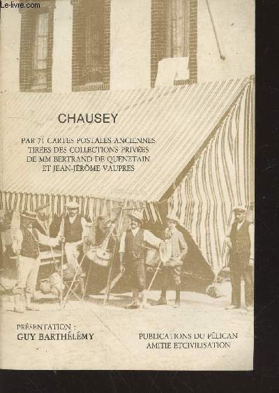
Barthélémy Guy
Chausey par 71 cartes postales anciennes tirées des collections privées de MM Bertrand de Quenetain et Jean-Jérôme Vaupres
Pélican Amitié et Civilisation. Non daté. In-8. Broché. Bon état, Couv. convenable, Dos satisfaisant, Intérieur frais. 54 pages augmentées de nombreuses photos de cartes postales en noir et blanc hors texte.. . . . Classification Dewey : 741.68-Illustrations des cartes postales
書籍販売業者の参照番号
: RO20213371
|
|
|
BARTRAM, William
Voyage dans les parties sud de l’Amérique septentrionale
In -8°, due volumi, pp. 457 con due tavole ripiegate, pp. 436 con 1 tavola ripiegata e grande carta geografica pieghevole a cura di J.B. Poirson e stampata da Blondeau, legatura in pelle, con tasselli e titolo al dorso. Nel secondo volume manca la quarta tavola ripiegata, tavola non presente in tutti gli esemplari (v. Stafleu & Cowan, 329 ed. fr.); all’antiporta del primo vol. illustrazione con Mico Chlucco, il Gran Guerriero o il Re dei Seminole. Prima edizione francese. Particolarmente dettagliata la carta geografica, importante per capire il livello di accuratezza raggiunto dalle esplorazioni scientifiche. In -8°, two volumes, pp. 457, with two large folded plates, pp. 436 with 1 folded plate and large folded map by J.B. Poirson and engraved by Blondeau, leather binding with title at the back. In the second volume the fourth folded plate is missing which is not existing in each copy, (see Stafleu & Cowan, 329 ed. fr.). At the frontispice of the first volume portrait of Mico Chlucco, the Great Warrior or the King of Seminoles. First French edition.
|
|
|
Based On The Esso Petroleum Companys Eight Road Maps Of Britain And Ireland.
Ancestral Britain: Pictorial Guide & Highway Maps
A.P.S.O. Ltd 1953. Paperback. Used; Good. <p><i><strong>Fast Dispatch. Expedited UK Delivery Available. Excellent Customer Service. </strong></i> <br/><br/>Bookbarn International Inventory #2300382</p> A.P.S.O. Ltd paperback
書籍販売業者の参照番号
: 2300382
|
|
|
BASEQUE L.
Construction des cartes de l'?tat-major (en Fran?e et en Belgique) et coordon?es rectilignes. Calculs tr?s simple des distance ? vol d'oiseau. A l'usage de l'enseignement, l'a?rostation, l'aviation et la colombophilie.
Broch?. 71 pages.
|
|
|
Basil Mathews . with Seventeen Illustrations by Ernest Prater Twenty Four Other Pictures and Photographs and Three Maps
Livingstone the Pathfinder by Basil Mathews . with Seventeen Illustrations by Ernest Prater Twenty-Four Other Pictures and Photographs and Three Maps
Missionary Education Movement Of The United States And Canada. Hardcover. Good. Binding: Hardback ---Publisher: Missionary Education Movement Of The United States And Canada ---Date: 1912 ---Edition: ---Pages: 211 ---Condition: Fair ---DJ Condition: None --- Description: All of the pages are unmarked uncreased and tightly bound the only flaws are some scuffs and light rubbing to the boards and spine and an inscription to the front endpaper and another to the inside front cover. MOST OF OUR BOOKS ARE SHIPPED WITHIN 1 WORKING DAY OF PURCHASE. WE UPLOAD A SELECTION OF HIGH QUALITY PHOTOGRAPHS WITH EACH LISTING HOWEVER IF NOT ALREADY PRESENT PHOTOGRAPHS OF ANY OF OUR TITLES CAN BE PROVIDED BY REQUEST VIA E-MAIL.--- P --- 488 Missionary Education Movement Of The United States And Canada hardcover
書籍販売業者の参照番号
: SKU1038797

|
|
|
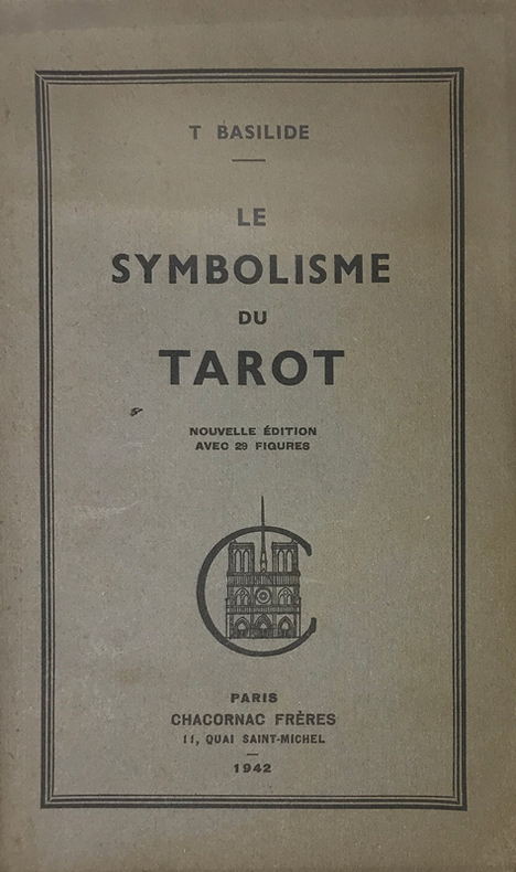
Basilide (Patrice Genty, 1883-1964, consacré évêque de l'Eglise Gnostique sous le nom de Taur) :
Symbolisme (Le) du Tarot. Nouvelle édition avec des figures.
Paris, Chacornac, 1942 ; in-8, brché ; (1) f. blanc, 53, (1) pp., couverture vert-olive imprimée en vert foncé.
書籍販売業者の参照番号
: 15259
|
|
|
Basse Seine
carte Basse Seine au 1/10 000e de Paris a Rouen
IN4 1950,2e edition,carte coloriée depliante en accordeon d’un sel tenant de Bougival a Tourville(Rouen),tres rare,complet,pres de 100Km de berges,
書籍販売業者の参照番号
: 17045
|
|
|
BASSET
Rome
Questo panorama di Roma risulta essere una copia di quello edito da Chereau intorno al 1730 circa. L’assenza del porto di Ripetta e della scalinata di Trinità dei Monti permette di datare il paesaggio ritratto al 1700 circa. La raffigurazione di San Pietro ricorda quella del Barriere che è forse da ritenersi il lontano prototipo di questa serie di vedute edite in Francia nel XVIII secolo.Di questa incisione è nota una variante, censita da Marigliani, che reca in basso l’indirizzo di François Basset, e la cui edizione risale al 1780 circa.È quindi possibile suppore che questo sia il primo stato della lastra, avanti l’indirizzo editoriale, oppure che Basset abbia successivamente acquisito il rame e pubblicato con l’aggiunta del proprio indirizzo.Incisione in rame, finemente colorata d'epoca, in basso tre righe di testo in francese e legenda numerica 1-16, in ottimo stato di conservazione. This panoramic view of Rome is a copy of the one published by Chereau around 1730 or so. The absence of the port of Ripetta and the stairway of Trinità dei Monti allows us to date the landscape portrayed to around 1700. The depiction of Saint Peter recalls that of the Barriere which is perhaps to be considered the prototype of this series of views published in France in the eighteenth century.Marigliani describes a copy bearing the address of François Basset below, and whose edition dates back to around 1780.It is therefore possible to suppose that this is the first state of the plate, before the editorial address, or that Basset has subsequently acquired the plate and then published it with the addition of his own address.Copper engraving, finely colored at the time, three lines of text in French at the bottom and numerical key 1-16, in excellent condition. C. Marigliani, "Le Piante di Roma delle collezioni private", tav. 174 (variante)

|
|
|
BASSET (André).
[NOTRE-DAME de PARIS] Vue perspective de l'intérieur de l'église de Notre Dame de Paris.
[circa 1780]. 280 x 390 mm.
書籍販売業者の参照番号
: LBW-5770

|
|
 検索結果のメールを受信する
 PDFファイルの検索結果をダウンロード
 RSSフィード


