|
|
|
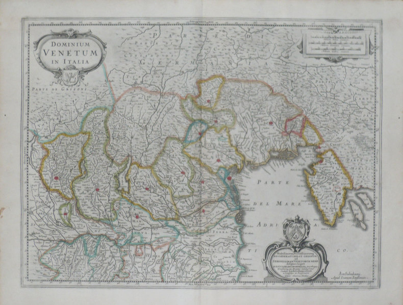
HONDIUS (Henricus);
[VENETIE] Dominium venetum in Italia.
Amsterdam 1639-1649 378 x 498 mm.
書籍販売業者の参照番号
: LBW-1468
|
|
|
HONGRIE
Carte du Royaume de Hongrie avec ses dépendances.
1779 trace de pliure. carte 245 x 330 mm., P. 1779
書籍販売業者の参照番号
: 15321
|
|
|
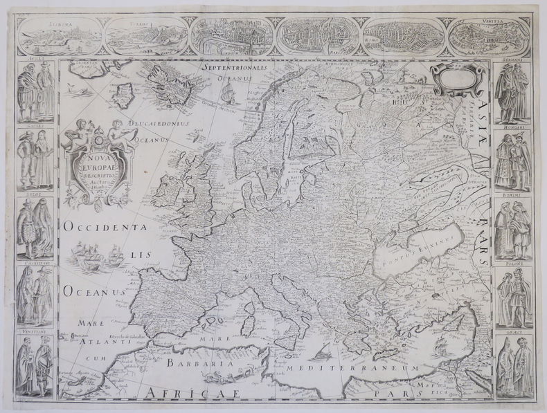
HONDIUS (Jodocus).
Nova Europæ descriptio.
[1659]. 407 x 541 mm.
書籍販売業者の参照番号
: LBW-772
|
|
|
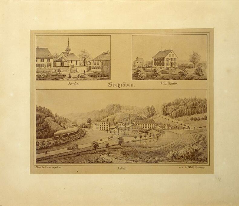
Honegger, Jakob Adolf:
Seegräben - Aathal.
Zürich, Photoraphie J. Ganz, (um 1900). Fotrogr. reproduzierte Tuschzeichnung. Format: 17,2 x 21,6 cm.
書籍販売業者の参照番号
: 463DG
|
|
|
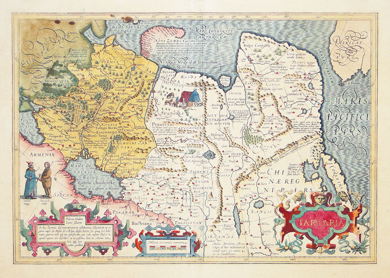
HONDIUS (Jodocus).
Tartaria.
[1606-1608]. 341 x 496 mm.
書籍販売業者の参照番号
: LBW-2706
|
|
|
HONDIUS Hendrick (Amsterdam 1597 - 1651)
Nova Totius Terrarum Orbis Geographica Ac Hydrographica Tabula
Buon esemplare della carta del mondo di Henricus (Hendrick) Hondius. Prova del terzo stato di quattro, con la data 1663 che sostituisce l'originale 1630, che si trova nell'Atlas Contractus di Jan Jansson e negli atlanti marini di H. Van Loon.I cartigli abbelliti e le illustrazioni bizzarre fanno di questa mappa un eccellente esempio di cartografia olandese in stile barocco. Circondata da scene mitiche e bestie fantastiche, la carta del mondo stessa include affascinanti illustrazioni di velieri, mostri marini e pesci.Henricus Hondius era figlio del famoso cartografo Jodocus Hondius, il cui ritratto appare nella mappa in basso a sinistra. La carta include anche i ritratti di Gerard Mercator, Claudio Tolomeo e Giulio Cesare. Questi ritratti non sono solo accattivanti e storicamente rilevanti, ma probabilmente sono intesi a connettere la cartografia olandese (esemplificata da Hondius e Mercator) alla tradizione cartografica classica.L'atlante di Mercator-Hondius è stato pubblicato per la prima volta dal padre del cartografo, Joducus Hondius, che acquistò le lastre dell'opera di Mercator, ristampandole ed integrandole con un numero sempre crescente di sue mappe. Oltre alle numerose e bellissime illustrazioni sono notevoli nella carta diverse curiosità geografiche, tra cui la California come isola, le reti fluviali e i laghi del Nord America e le coste dell'Australia. In Sud America, lo Stretto di Le Maire appare ora ad est dello Stretto di Magellano. Lo Stretto di Le Maire era stato scoperto solo quindici anni prima della pubblicazione del primo stato di questa mappa, quando Jacob Le Maire e Willem Schouten condussero una circumnavigazione per minare il monopolio commerciale della Compagnia olandese delle Indie Orientali (VOC). L'inclusione della costa australiana in questa mappa traccia l'inizio della conoscenza olandese del continente australiano, quando la notizie di una "sconosciuta massa di terra ignota meridionale" si stava rapidamente diffondendo.Acquaforte, finemente colorata a mano, in ottime condizioni. A good example of the Henricus Hondius’ world map, a third state with the date 1663 that can be found in the Atlas Contractus of Jan Jansson and in sea atlases of Van Loon.The embellished cartouches and whimsical illustrations make this map an excellent example of baroque-style Dutch cartography. Bordered by mythical scenes and fantastic beasts, the world map itself includes charming illustrations of sailing vessels and fish, adding further visual interest to an already engaging tableau.The mapmaker Henricus Hondius was the son of famed cartographer Joducus Hondius, whose portrait appears at bottom left. The map also includes portraits of Gerardus Mercator, Claudius Ptolemy, and Julius Caesar. These portraits are not only eye-catching and historically relevant, but also serve to establish Dutch cartography (exemplified by Hondius and Mercator) alongside the Roman cartographic tradition.The Mercator-Hondius atlas was first published by the mapmaker’s father, Joducus Hondius. Joducus Hondius secured Mercator’s map engravings from Mercator’s relatives and republished them, along with his own work. The atlas was incredibly commercially successful, and its world map remained unchanged from Mercator’s depiction until the creation of this map by Henricus Hondius and partner Jan Jansson. This Hondius-Jansson version of the Mercator world map was included in all issues of the Mercator-Hondius atlases from 1633 until at least 1658.In addition to the numerous beautiful illustrations and map details, several geographic features included on this map are notable, including California as an island, the riverine networks and lakes of North America, and the coastline of Australia. California is shown here as an island, reflecting a widespread belief among Europeans from the sixteenth to eighteenth centuries. In South America, the Le Maire Strait now appears east of the Strait of Magellan. The Le Maire Strait had been discovered only fifteen years before the first state of this map was published, when Jacob Le Maire and Willem Schouten led a circumnavigation to undermine the trade monopoly of the Dutch East India Company (VOC). Setting this map apart from its contemporaries, it also includes an early appearance of Australia's northern coastline. The inclusion of the Australian coast on this map traces the beginning of Dutch knowledge of the Australian continent, preserving a moment in time when “The Unknown Southern Land” was quickly becoming known.Copperplate with fine hand colouring, in good condition. Shirley, The Mapping of the World: Early Printed World Maps, 1472-1700, map 336

|
|
|
HONDIUS Jodocus (Amsterdam 1563 - 1612)
Typus Orbis Terrarum
Carta tratta dalla prima edizione della Cosmographia Universalis di Paulus Merula, stampata ad Amsterdam nel 1605. Le mappe usate per illustrare la prima edizione della Cosmografia di Merula sono realizzate nel 1598 da Jodocus Hondius e Pieter Van den Keere (Kaerius) e quindi utilizzate dall'editore Cornelis Claesz per illustrare lavori di Apian, Linschoten e Merula. Incisione in rame, inserita in una pagina di testo, in perfette condizioni. Map of the World from the first edition of Cosmographia Universalis by Paul Merula, printed in Amsterdam in 1605.The map was first issued in 1598 by Cornelis Claesz and engraved and realized by Jodocus Hondius and Pietre vand den Keere (Kaerius). Claesz used the plate to illustrate various works he published by Peter Apian, Jan van Linschoten, Paul Merula and others. Copperplate, inset in a page text, very good conditions. King, Miniature Maps, pp. 80/81.

|
|
|
HONDIUS Jr. Jodocus (Amsterdam 1594 -1629)
Typus Orbis Terrarum
Carta geografica tratta dal Tabularum Geographicarum contractarum libri septem di Petrus Bertius, edizione latina del 1616. L'opera contiene 219 carte che illustrano questa nuova versione della geografia del Bertius, per la prima volta pubblicata nel 1612 con le carte di Barent Langenes. Le carte derivano dal grande atlante di Mercator/Hondius, delle quali molte rappresentano una semplice riduzione. "After the death of Cornelis Claesz in 1609, Jodocus Hondius II became the new publisher of the work, composed by 7 parts in 1, with engraved title-page and 220 full-page engraved maps in text. All the maps were newly engraved and slightly larger in size, because Hondius was not able to acquire the original plates. With the new plates the work was definitely improved and enjoyed a growing demand of the public, which at that time had the choice between the Atlas Minor by Mercator and Bertius' Tabularum Geographicarum. The 219 plates, with the oval world map appearing twice, were produced to illustrate a new version of the geography of Bertius, published in 1616. According to King, their correct attribution is by Hondius, after Mercator and Hondius, taken from Bertius, who was only responsible for revising his text again" [cfr. G. King, Miniature Antique Maps]. Incisione in rame, perfette condizioni. A superior rival to the pocket Ortelius atlas appeared about 1598, under the imprint of Barent Langenes and Cornelis Claesz. Claesz also published the Tabularum Geographicarum contractarum libri septem, edition with texy by Petrus Bertius, in 1600. After the death of Cornelis Claesz in 1609, Jodocus Hondius II became the new publisher of the work, composed by 7 parts in 1, with engraved title-page and 220 full-page engraved maps in text. All the maps were newly engraved and slightly larger in size, because Hondius was not able to acquire the original plates. With the new plates the work was definitely improved and enjoyed a growing demand of the public, which at that time had the choice between the Atlas Minor by Mercator and Bertius' Tabularum Geographicarum. The 219 plates, with the oval world map appearing twice, were produced to illustrate a new version of the geography of Bertius, published in 1616. According to King, their correct attribution is by Hondius, after Mercator and Hondius, taken from Bertius, who was only responsible for revising his text again. "After the death of Cornelis Claesz in 1609, Jodocus Hondius II became the new publisher of the work, composed by 7 parts in 1, with engraved title-page and 220 full-page engraved maps in text. All the maps were newly engraved and slightly larger in size, because Hondius was not able to acquire the original plates. With the new plates the work was definitely improved and enjoyed a growing demand of the public, which at that time had the choice between the Atlas Minor by Mercator and Bertius' Tabularum Geographicarum. The 219 plates, with the oval world map appearing twice, were produced to illustrate a new version of the geography of Bertius, published in 1616. According to King, their correct attribution is by Hondius, after Mercator and Hondius, taken from Bertius, who was only responsible for revising his text again" [cf. G. King, Miniature Antique Maps]. Copperplate, in very good conditions. Koeman p. 42; King p. 96/99.

|
|
|
HONDIUS Jr. Jodocus (Amsterdam 1594 -1629)
Typus Orbis Terrarum
Carta geografica tratta dal Tabularum Geographicarum contractarum libri septem di Petrus Bertius, edizione latina del 1616. L'opera contiene 219 carte che illustrano questa nuova versione della geografia del Bertius, per la prima volta pubblicata nel 1612 con le carte di Barent Langenes. Le carte derivano dal grande atlante di Mercator/Hondius, delle quali molte rappresentano una semplice riduzione. "After the death of Cornelis Claesz in 1609, Jodocus Hondius II became the new publisher of the work, composed by 7 parts in 1, with engraved title-page and 220 full-page engraved maps in text. All the maps were newly engraved and slightly larger in size, because Hondius was not able to acquire the original plates. With the new plates the work was definitely improved and enjoyed a growing demand of the public, which at that time had the choice between the Atlas Minor by Mercator and Bertius' Tabularum Geographicarum. The 219 plates, with the oval world map appearing twice, were produced to illustrate a new version of the geography of Bertius, published in 1616. According to King, their correct attribution is by Hondius, after Mercator and Hondius, taken from Bertius, who was only responsible for revising his text again" [cf. G. King, Miniature Antique Maps]. Incisione in rame, perfette condizioni. A superior rival to the pocket Ortelius atlas appeared about 1598, under the imprint of Barent Langenes and Cornelis Claesz. Claesz also published the Tabularum Geographicarum contractarum libri septem, edition with texy by Petrus Bertius, in 1600. After the death of Cornelis Claesz in 1609, Jodocus Hondius II became the new publisher of the work, composed by 7 parts in 1, with engraved title-page and 220 full-page engraved maps in text. All the maps were newly engraved and slightly larger in size, because Hondius was not able to acquire the original plates. With the new plates the work was definitely improved and enjoyed a growing demand of the public, which at that time had the choice between the Atlas Minor by Mercator and Bertius' Tabularum Geographicarum. The 219 plates, with the oval world map appearing twice, were produced to illustrate a new version of the geography of Bertius, published in 1616. According to King, their correct attribution is by Hondius, after Mercator and Hondius, taken from Bertius, who was only responsible for revising his text again. "After the death of Cornelis Claesz in 1609, Jodocus Hondius II became the new publisher of the work, composed by 7 parts in 1, with engraved title-page and 220 full-page engraved maps in text. All the maps were newly engraved and slightly larger in size, because Hondius was not able to acquire the original plates. With the new plates the work was definitely improved and enjoyed a growing demand of the public, which at that time had the choice between the Atlas Minor by Mercator and Bertius' Tabularum Geographicarum. The 219 plates, with the oval world map appearing twice, were produced to illustrate a new version of the geography of Bertius, published in 1616. According to King, their correct attribution is by Hondius, after Mercator and Hondius, taken from Bertius, who was only responsible for revising his text again" [cf. G. King, Miniature Antique Maps]. Copperplate, in very good conditions. Shirley 291

|
|
|
Honegger, Jakob Adolf
Seegräben - Aathal.
Zürich, Photoraphie J. Ganz, (um 1900). Fotrogr. reproduzierte Tuschzeichnung. Format: 17,2 x 21,6 cm. + Wichtig: Für unsere Kunden in der EU erfolgt der Versand alle 14 Tage verzollt ab Deutschland / Postbank-Konto in Deutschland vorhanden +, 463DG
書籍販売業者の参照番号
: 463DG

|
|
|
Hooker Sir William Jackson; George A. Walker Arnott
THE BRITISH FLORA: Comprising the Phaenogamous or Flowering Plants and the Ferns COLOURED PLATE EDTION.
London: Longman Green Longman and Roberts 1860. pp. xlvii 1 636; 12 fine hand-coloured plates each with a leave of explanation adjacent. Original red pebbbled cloth binding with gilt lettering with a little general wear and rubbing small repair to head of the spine which is lightly faded and marked. Contents clean and tight original pale yellow end papers which are spotted to the reverse no annotation plates clean and crisp. A very good copy with 12 finely hand-coloured plates. The Eighth Edition. Hardback. Very Good/No dust jacket. 8vo. Longman, Green, Longman and Roberts Hardcover
書籍販売業者の参照番号
: 023223
|
|
|
Hopkins, Anthony ; Havord, Bryn
Anthony Hopkins' Snowdonia
Book and jacket in virtually mint condition. 112pp. Superb photographic study of the Snowdonia region of North Wales with detailed descriptive text.

|
|
|
Hopkirk Peter. maps Denis Baker
Trespassers on the Roof of the World: The Secret Exploration of Tibet. Kodansha Globe Tibet the Forbidden Land; Red Guards at Lhasa
Tokyo ; New York : Kodansha International 1995. 1995. As New. 2nd printing ; viii 276 pp. 14 pp. of plates : illustrations maps ; 22 cm. ; ISBN: 1568360509 ; LCCN: 94-48629 ; OCLC: 31776720 ; Originally published: 1st American ed.: Los Angeles: J. P. Tarcher ; AS NEW Tokyo ; New York : Kodansha International, 1995. unknown
書籍販売業者の参照番号
: 2849 ISBN : 1568360509 9781568360508

|
|
|
HORSETZKY, Adolf von:
38 (sic = 42) Tafeln zur Kriegsgeschichtlichen Übersicht der wichtigsten Feldzüge in Europa seit 1792. Atlas und Textband. (6., neubearb. Aufl.)
Seidel & Sohn, Wien, 1905. in-4to, ATLAS: 2 Bl. (Titel - Verzeichniss) + 42 gef. Karten. Tafel I-XXXVIII + 1 gef. Übersichts-Blatt, (incl. Tafel XV (Südwestl. Theil - in der Série gezählt) + Tafel XV - Nordostl. Theil + Tafel XV - Südostl. Theil + Tafel XV - Nordwestl, Theil. / TEXTBAND.: XXIV + 718 S., Tafeln in original Halbleinen Kartenmappe / O.-Halbleder mit Ecken.
書籍販売業者の参照番号
: 101163aaf
|
|
|
HORNEMANN (Friedrich Konrad).
Voyage dans l'Afrique septentrionale, depuis Le Caire jusqu'à Mourzouk, capitale du royaume de Fezzan ; suivi d'Eclaircissemens sur la Géographie de l'Afrique, par M. RENNELL. Traduit de l'anglais par … et augmenté de notes et d'un Mémoire sur les Oasis, composé principalement d'après les auteurs arabes par L. LANGLÈS.
Paris, Dentu, An XI (1803). 2 parties (pagination continue) en un vol. in-8, basane fauve marbrée, dos lisse orné, p. de titre rouge, tr. rouges (reliure de l'époque). Reliure restaurée, illustré de 2 grandes cartes dépliantes.
書籍販売業者の参照番号
: PHO-1651
|
|
|
Horton Family Maps
Street maps Santa Fe Espanola Los Alamos Taos
1999-01-01. New. Ships with Tracking Number! INTERNATIONAL WORLDWIDE Shipping available. May be re-issue. Buy with confidence excellent customer service! unknown
書籍販売業者の参照番号
: 0883077663n ISBN : 0883077663 9780883077665

|
|
|
Horton Family Maps
Street maps Santa Fe Espanola Los Alamos Taos
1999-01-01. Good. Ships with Tracking Number! INTERNATIONAL WORLDWIDE Shipping available. May not contain Access Codes or Supplements. May be re-issue. May be ex-library. Shipping & Handling by region. Buy with confidence excellent customer service! unknown
書籍販売業者の参照番号
: 0883077663 ISBN : 0883077663 9780883077665

|
|
|
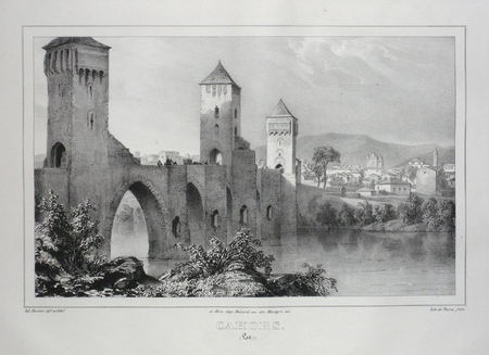
HOSTEIN;
CAHORS (Lot).
Paris Benard circa 1850 213 x 298 mm.
書籍販売業者の参照番号
: LBW03d5a
|
|
|
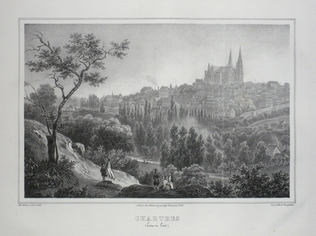
HOSTEIN.
CHARTRES (Eure et Loire).
Paris, Benard, [circa 1850]. 220 x 293 mm.
書籍販売業者の参照番号
: LBW03d77
|
|
|
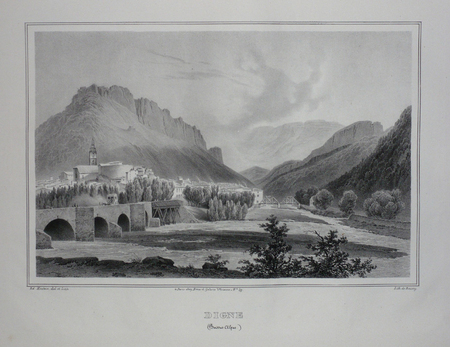
HOSTEIN;
DIGNE (Basses Alpes).
Paris Benard circa 1850 226 x 288 mm.
書籍販売業者の参照番号
: LBW03d62
|
|
|
Hoskins, Franklin E.
FROM THE NILE TO NEBO. A Discussion of the Problem and the Route of the Exodus. With 85 Illustrations.
378 p. + Plus Frontis and full page photographs and maps. Large folding tissue map of Sinai peninsula with the route of the Exodus in red. Title page printed in red and black. Robert C. Bair's copy, with his notations in pencil. Robert C. Bair, a lawyer and son of a local judge was involved in politics and served as the Director of Historical Society of York County. Quarto. Original full green cloth binding, lettered in gold. Extremities bumped and slightly worn. Hardbound. First Edition. HOLY LAND BOX 1
|
|
|
Hostert, Walter Dr
Historische Landkarten. - Das Land an Ruhr, Lenne, Hönne und Volme auf historischen Karten aus der Sammlung des Museums der Stadt Lüdenscheid.
Lüdenscheid, Heimatbund Märkischer Kreis (=Veröffentlichungen des heimatbundes Märkischer Kr., 1982. 1. Aufl. mit vielen teils farb. Abb. + Tafeln. ill. OPbd., farb. ill. OU., 140 S., 4°.
書籍販売業者の参照番号
: 3676
|
|
|
HOUPLAIN (Jacques).
Carte de voeux illustrée d'une gravure originale signée.
Paris Société des peintres-graveurs français 1989 1 vol. Broché Longue carte de voeux dépliante sur Arches illustrée d'une eau-forte (9 x 25 cm) justifiée 69/200 et signée par Jacques Houplain. En parfait état.
書籍販売業者の参照番号
: 109094
|
|
|
HOUARD-DEVERT (Benoît-André)
I - Moyens d'améliorer le Commerce et d'augmenter la valeur des propriétés de plusieurs faubourgs et quartiers de Paris, lesquels sont maintenant les moins opulents, les moins riches, les moins marchands, les plus mal bâtis...où l'on distingue plusieurs Avenues, Boulevards, Canaux, Chaussées, Halles, Ponts, Quais et Rues nouvellement proposés à établir en mémoire des hommes célèbres cités dans ce même ouvrage. Accompagnés de plusieurs plans et dessins d'Architecture, gravés géométriquement et enluminés... par une Société d'Artiste.II - Tableau indicateur des rues, places et carrefours de Paris dont le dégagement et l'élargissement sont réclamés depuis longtemps... conçu par un Artiste français, le 12 mai 1825, jour de sa 63ème année. III - Précis historique des Canaux de l'Ourcq de St Denis et de St Maur à Paris, gravés géométriquement par Berthelomet d'après les dessins et données de M. B. H. D....IV - DEVERT. Plan et description de la scie mécanique ou Machine à couper,..., destinés à établir les Pilotis au fond de l'eau...V - Concession des propriétés pour objet d'utilité publique ou Lois relatives aux alignements des rues actuelles et formation de nouvelles...décrétées par l'Assemblée Législative le 16 sept. 1807 et ... révisée à Paris en 1824, par S. M. VI - Agriculture, commerce et navigation ou Plan... suivi de divers articles proposés pour la confection de plusieurs Canaux de navigation, entr'autres celui du golfe de Venise au golfe de Gênes et de Lion, pour abréger la navigation de plus de 300 lieues, par M. B. A. H. de Vert. VII - Pans divers des embellissements de Paris et des moyens qu'il conviendrait d'employer pour y améliorer la salubrité, de même que pour y faciliter le commerce de son intérieur...VIII - DEVERT (M. B. A. H.) Analyse des canaux des Rivières de l'Yvette, de la Bièvre, de l'Orge, de la Juine et de l'Essone... pour y conduire une portion de leurs eaux à Paris…
1824 cartonnage, étiquette vieux rose. in-4, 20pp., 8pp., 1 pl., ; 8pp., 1 carte dépl. ; 8pp., 1 pl. dépl.; 8pp., 1 pl. dépl. ; 8pp., 1 pl., 1 carte dépl. ; 8pp., 1 pl. ; 8pp., 1 plan de Paris dépl. P. Hautecoeur-Martinet (ca. 1824)
書籍販売業者の参照番号
: 13108

|
|
|
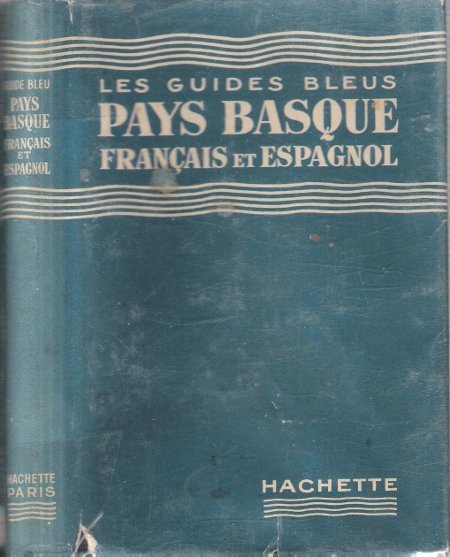
HOULET Gilbert
Les Guides Bleus : Pays Basque Français et Espagnol . Complet De Sa Carte Dépliante En Couleurs
Paris Librairie Hachette 1954 In 16 Collection " Les Guides Bleus " . Excursions , nombreux plans de voyage et de villes en noir et blanc . Une grande carte dépliante en fin d'ouvrage . Index . Cartes et Plans .- 236 p. + plans , 450 gr.
書籍販売業者の参照番号
: 012340
|
|
|
HOUPLAIN (Michel).
Menu illustré d'une gravure originale signée.
Paris Les Impénitents 1983 2 vol. Broché Menu dépliant sur Arches illustré d'une eau-forte (7.5 x 13 cm) signée par Michel Houplain. . En parfait état.
書籍販売業者の参照番号
: 109171
|
|
|
HOUPLAIN (Michel).
Menu illustré d'une gravure originale signée.
Paris Les Impénitents 1983 2 vol. Broché Menu dépliant sur Arches illustré d'une eau-forte (7.5 x 13 cm) signée par Michel Houplain. . En parfait état.
書籍販売業者の参照番号
: 109171
|
|
|
HOUGHTON (Major), PARK (Mungo)
Voyages et découvertes dans l'intérieur de l'Afrique, par le major Hougton et Mungo-Park, deux agens de la Société établie en Angleterre, pour favoriser les progrès des découvertes dans cette partie du monde. Rédigés par le comité de la Société, et publié par son ordre.
Paris, Tavernier, an VI [1798]. In-4de (4) ff.-120 pp., 3 cartes dépliantes, cartonnage d'attente, non rogné, manque au dos
書籍販売業者の参照番号
: PHO-1632
|
|
|
HOULE MARCY; GOETZE ERIK MAPS
One City's Wilderness: Portland's Forest Park
Oregon State University Press. Softcover. Brand new book. Situated in the rugged hills west of Portland Oregon Forest Park is one of the largest urban parks in the world and the only city wilderness park in the United States. The park is home to hundreds of native plants and animals and offers more than eighty miles of trails�all within minutes of downtown Portland. This updated and expanded edition of One City's Wilderness provides directions to twenty-nine hikes of varying length difficulty and scenery covering every trail within the 5100-acre park. Each hike is accompanied by new full-color maps and a fold-out full-color map of the entire park is included inside the back cover. Marcy Houle shares the history of Forest Park introduces the people who fought to preserve it and explores the role stewards play today. She describes the park's critical wildlife corridor its exceptional watersheds and its important native interior forest habitat. She encourages people of all ages to take an "All Trails Challenge"�learning about the unique nature of the park by exploring every trail. For its recreational and educational opportunities as well as its extraordinary natural beauty Forest Park is unquestionably America's premier urban forest. One City's Wilderness in its updated third edition continues to be the authoritative complete guide to Portland's greatest natural resource. Full color trail maps for 29 hikes Fold-out color map of entire park 84 color photographs of native plants and birds Park history geology watersheds vegetation and wildlife Bird plant and mammal checklists Oregon State University Press paperback
書籍販売業者の参照番号
: 78162X1
|
|
|
HOULET Gilbert
Les Guides Bleus : Pays Basque Français et Espagnol . Complet De Sa Carte Dépliante En Couleurs
Collection " Les Guides Bleus " . Excursions , nombreux plans de voyage et de villes en noir et blanc . Une grande carte dépliante en fin d'ouvrage . Index . Cartes et Plans .- 236 p. + plans , 450 gr.
|
|
|
Hoursch & Bechstedt (Hrsg.)
Relief-Panorama des Rheines von Köln bis Mainz
Köln-Ehrenfeld, Hoursch & Bechstedt, (ca. 1925). Mit Text im Bild - illustr. Okt., Hochformat (25,5 x 12,8 cm) enthaltend ein 15-teiliges, gefaltetes Farbdruckleporello (ausgeklappt 172 x 25 cm) - Reihe: Nr. 6. [2 Warenabbildungen]
書籍販売業者の参照番号
: 23338

|
|
|
Hourtoulle F. G.; McKay Alan transl; Jouineau Andre uniforms and Morgan Gillard maps.
Jena - Auerstaedt:
Paris:: Histoire & Collections 2005. Hardcover. Near Fine. 120 pp. 4to. Hardcover. Very light scuffing flexing & shelfwear to boards. Slight shelfwear cocking & shaking to spine but binding very sturdy. Pgs clean & crisp. Histoire & Collections, hardcover
書籍販売業者の参照番号
: 155979 ISBN : 2915239762 9782915239768

|
|
|
Housman, John (1764-1802).
A DESCRIPTIVE TOUR, AND GUIDE TO THE LAKES, CAVES, MOUNTAINS, AND OTHER NATURAL CURIOSITIES, IN CUMBERLAND, WESTMORELAND, LANCASHIRE, AND A PART OF THE WEST RIDING OF YORKSHIRE. The Second Edition, Embellished with Several Additional Plates.
pp. v, (4), 226, (2) + Plus engraved Frontis, Plates of scenes and large folding maps and charts. One map includes the sketch of soils, canals, etc of Lancashire. LACKS full page plate of Furness Abbey. View of Keswick Lake repeated on page 107 and 125. View of Bassenthwaite omitted. Two pages have old tape repairs with no loss. Map of the districts has small tape repair on one fold. Offsetting from Frontis on title page. Age stained and foxed. Engraved amoral bookplate of William Scott Elliot of Arkleton. 8vo. 215 mm. Original full leather binding. Boards detached. Small loss on spine. Binding worn. Hardbound. A rather poor copy of a great book. SCARCE. **PRICE JUST REDUCED! TRAVEL/7
|
|
|
Howe John:
Carton d'invitation, Galerie La Marge.
Lausanne, La Marge. Carton d'invitation imprimé recto-verso, au format 10 x 21 cm.
書籍販売業者の参照番号
: 12499

|
|
|
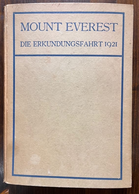
HOWARD-BURY C. K:
Mount Everest: die Erkundungsfahrt 1921. Deutsch von W. Rickmer Rickmers.
Basel, Schwabe, 1922. Grand in-8 de VIII-299 pages, cartonnage d'éditeur.
書籍販売業者の参照番号
: 19829
|
|
|
Howe, C.D.; White, J.H.
Trent Watershed Survey: A Reconnaissance
156 pages. Index. Excellent black and white photos. Nice colour map entitled "Forest Distribution in Trent River Watershed" (34"x36") stored in pocket inside back board. Also present is a colour map entitled "Crown Timber Lands 1912" which covers the same geography and measures 21"x20". Final item in pocket is a chart showing "Classification of Land, Trent Watershed, Ont. 1912". Gilt lettering upon backstrip and front board. Initials upon front free endpaper else unmarked. Binding sound. Average wear. Sound copy. Book

|
|
|
Howell F. & F. Bourliere eds. and b & w Photos Maps
African Ecology and Human Evolution.
Paperback. Good. paperback
書籍販売業者の参照番号
: 6E-MCHA-CDTM
|
|
|
Howell, Arthur H.
FLORIDA BIRD LIFE.
pp. xxiv, 579 + Color plates after paintings by Francis L. Jaques, with guards and explanations + Photographic plates + Folding colored map. Small 4to. 25 cm. Plain cloth binding. "Florida occupies a unique position biologically among the States of the Union and has been a Mecca for naturalists. Comprising a long narrow peninsula projecting southward into the tropics, and provided with myriad lakes, ponds, marshes, and tidal lagoons, it is an attractive lane of migration for many birds and furnishes an ideal home at all seasons for immense numbers of waterfowl, shorebirds, and swamp-loving species." - Introduction. A nice clean copy of a invaluable work that contains a description of each bird found in Florida, with: its range, distribution, haunts, habits, food, recognition marks, etc. Ripley 138. NH7
|
|
|
Hoyerswerda:
Hoyerswerda. "Plan der Action welche d. 25. September 1759 zwischen dem Oesterreichischen und einem Königl.Preussischen Corps bei Hoyerswerda in Sachsen vorgefallen". Schlachtenplan von Hoyerswerda. Kupferstich mit farbigen Truppenaufstellungen aus "Neues Kriegs-Theater ...", 13. Supplement.
Format: 18 x 29,5 cm. *Leicht gebräunt, insgesamt gut erhalten. Landkarten de
|
|
|
Hoyler, H.M.; Long, F.A.; Moore, R.; Pierce, P.N.; Fitzgerald, E.F.; Liggett, T. Jr.; Wismer, R.H.; Moore, C.E.; Dodd, Joe
Marine Corps Gazette - Professional Magazine for United States Marines, April (Apr.) 1960, Number 4, Volume 44 - Sikorsky S-60 Sky Crane
72 pages. Features: 1960 Slates; Fort Lejeune fold-out cover illustration; and more. High Standard Manufacturing Corporation ad features photos of shooting prize winners Santiago Machuca, John C. Forman, David Cartes, Aubrey E. Smith, Roy Ratliff, and Richard Stineman; The Jet Age Wall - Are SAC and the ICBM offensive or defensive?; Embarkation Planning; The Marine Reserve; Peacetime Heroes; Report from the Ready Forces, The 2d Marine Division - Part I - Combat Readiness, and Part II - Programs to Improve Readienss; Write it Right; Your Ideas Wanted; The Salty Skipper; Brainstorming; Better Reserve Training; Sky Crane - the Sikorsky S-60; and more. Average wear. Unmarked. A sound vintage copy. Magazine

|
|
|
Hoys, Dudley
English Lakeland in Colour
Inscription inside front board. No other marks. A very clean very tight copy with bright unmarked boards and no bumping to corners. Dust jacket not price clipped or marked or torn with very minor creasing to lower front edge. 95pp. Half of the book is a description of the Lakes and its history and the other half is a series of full-page colour photographs and detailed notes on each.

|
|
|
HOÜEL Jean-Pierre-Louis-Laurent:
Voyage pittoresque des isles de Sicile, de Malte et de Lipari: où l'on traite des antiquités qui s'y trouvent encore, des principaux phénomènes que la nature y offre, du costume des habitants, & de quelques usages.
A Paris, de l'imprimerie de Monsieur, 1782 - 1787. 4 volumes grand in-folio de VIII-138; [4]-148; [4]-126; [4]-124 pages, demi-chagrin vert, dos lisses orné de filets et fleurons dorés. Non rogné. Reliures restaurées.
書籍販売業者の参照番号
: 18751
|
|
|
Hryniuk, Angela
No Visual Scars
79 pages. "A responsively irritable record of how it is to live bodily life now that the old maps don't tell us the truth. Hryniuk writes with intelligence and conscience. Her book has startling insights to offer." - Brian Fawcett. Clean and unmarked with light wear. Nice copy. Book
|
|
|
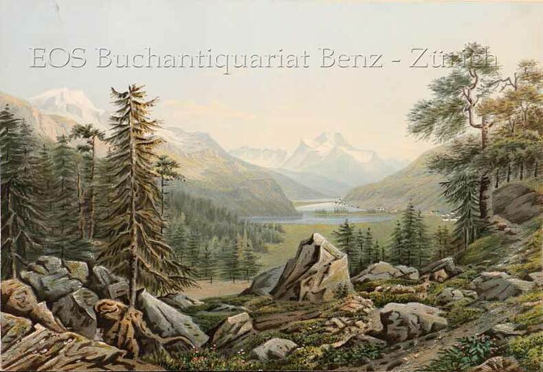
Huber, Caspar Ulrich (1825-1882):
Silvaplana mit See gegen den Piz della Margna.
Zürich, Henri Füssli & Comp., um 1860. Altkolorierte Aquatinta auf festem Papier. 16 x 23,4 cm.
書籍販売業者の参照番号
: 704CG
|
|
|
Huber, Caspar Ulrich (1825-1882)
Silvaplana mit See gegen den Piz della Margna.
Zürich, Henri Füssli & Comp., um 1860. Altkolorierte Aquatinta auf festem Papier. 16 x 23,4 cm. + Wichtig: Für unsere Kunden in der EU erfolgt der Versand alle 14 Tage verzollt ab Deutschland / Postbank-Konto in Deutschland vorhanden +, bild
書籍販売業者の参照番号
: 704CG

|
|
|
HUDSON'S BAY COMPANY
Canada; to Commemorate Our 322nd Birthday; Road Atlas Plus 6 Postcards
folio [39 x 28 cm]; unpaginated, national map, maps of each province, inset maps of main cities, all maps in color, mileage chart, legend, index of towns and cities. original pictorial printed heavy paper wraps with title historic map showing trading posts, etc on cover, name on margin, near fine and clean with the postcards intact. A picture of this book is available upon request by email. This copy has the 4 page insert of ads from The Bay that was included with the atlas.
|
|
|
HUGGINS (William John).
[PÊCHE à la BALEINE] South Sea whale fishery.
London, W.J. Huggins, 1825 [circa 1840]. 402 x 504 mm, sur papier fort.
書籍販売業者の参照番号
: LBW-8029

|
|
|
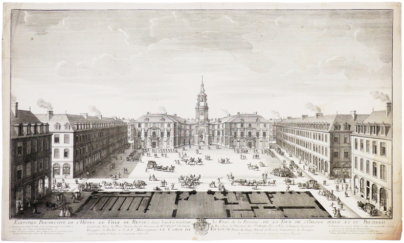
HUGUET (Jean-François).
[RENNES] Élévation perspective de l'Hôtel de Ville de Rennes dans lesquels se tiendront les États de la province, de la Tour de l'Orloge public et du Présidial, construits dans la Place Neuve.
Paris, V.ve de F. Chéreau, 1738. 332 x 563 mm.
書籍販売業者の参照番号
: LBW-5405
|
|
|
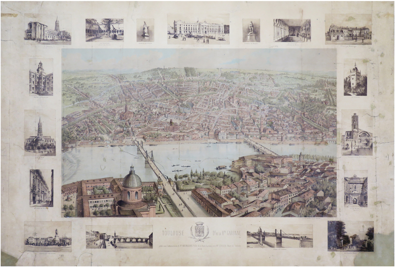
HUGO d'ALESI (Frédéric Alexianu dit).
[TOULOUSE] Toulouse. D.t de la H.te-Garonne.
1886. 630 x 912 mm.
書籍販売業者の参照番号
: LBW-7031
|
|
|
 検索結果のメールを受信する
 PDFファイルの検索結果をダウンロード
 RSSフィード


