|
Historical Maps
Past & Present Map 1840 - Present Day - Chester & Ellesmere Port Cheshire
Cassini. Map. New. FLOPPY Cassini unknown
書籍販売業者の参照番号
: BD7-9781847364067 ISBN : 1847364063 9781847364067
|
|
|
Historical Maps
Popular Edition 1924-25: Wensleydale & Upper Wharfedale OS98 Yorkshire
Cassini. Map. New. FLOPPY Cassini unknown
書籍販売業者の参照番号
: BD7-9781847361912 ISBN : 1847361919 9781847361912
|
|
|
Historical Maps
Revised Edition 1898-1900 - Minehead & Brendon Hills OS181 Somerset
Cassini. Map. New. B-FORMAT Cassini unknown
書籍販売業者の参照番号
: BD7-9781847363138 ISBN : 184736313x 9781847363138
|
|
|
Historical Maps
Revised Edition 1897-1898 - Maidstone & Royal Tunbridge Wells OS188 Kent
Cassini. Map. New. B-FORMAT Cassini unknown
書籍販売業者の参照番号
: BD7-9781847362902 ISBN : 1847362907 9781847362902
|
|
|
Hitti Philip K. Philip Khuri 1886 1978. ; maps Joseph P. Ascherl
Makers of Arab history. Religious and political. Muhammad : triple initiator of religion nation and state -- 'Umar Ibn-al-Khattab : founder of the Moslem empire -- Mu'awiyah : architect of the Arab empire -- 'Abd-al-Rahman I : maker of history on European soil -- Al-Ma'mun : radical caliph and intellectual awakener of Islam -- 'Ubaydullah al-Mahdi : founder of the Fatimid empire in Africa -- Salah-al-Din : hero of the anti-crusades -- pt. 2: Intellectual. Al-Ghazzali : greatest theologian of Islam -- Al-Shafi'i : founder of the science of Islamic law -- Al-Kindi : philosopher of the Arabs -- Ibn-Sina : prince of physicians and philosophers -- Ibn-Rushd : the great commentator -- Ibn-Khaldun : first philosopher of history
New York Harper & Row 1971 1971. Book. Very Good. Soft cover. 268 p. maps. 20 cm. ; ISBN: 0061315486 pbk.; 9780061315480 pbk. ; Harper torchbooks ; stiff paper wrappers ; label on back cover ; TB1548; OCLC: 830405 ; LC: D198.3; Dewey: 909.0976 ; originally published by St. Martin's Press in 1968 ; ".provides in-depth profiles of thirteen prominent figures of Islamic history. These eminent Muslims from Mohammed PBHN to Ibn Khaldun are presented in sketches that personify these outstanding men and profiling them as products of their respective times rather than merely chronicling their achievements." ; Contents: pt. 1: Religious and political. Muhammad : triple initiator of religion nation and state -- 'Umar Ibn-al-Khattab : founder of the Moslem empire -- Mu'awiyah : architect of the Arab empire -- 'Abd-al-Rahman I : maker of history on European soil -- Al-Ma'mun : radical caliph and intellectual awakener of Islam -- 'Ubaydullah al-Mahdi : founder of the Fatimid empire in Africa -- Salah-al-Din : hero of the anti-crusades -- pt. 2: Intellectual. Al-Ghazzali : greatest theologian of Islam -- Al-Shafi'i : founder of the science of Islamic law -- Al-Kindi : philosopher of the Arabs -- Ibn-Sina : prince of physicians and philosophers -- Ibn-Rushd : the great commentator -- Ibn-Khaldun : first philosopher of history. ; Philip K. Hitti was educated at the American University of Beirut and at Columbia University in New York. He received his Ph.D. in history from Columbia in 1915 two years after he had settled in the United States. In 1925 following a number of years of teaching at Columbia and at American University of Beirut he accepted an appointment at Princeton University where he remained until his retirement in 1954. He became the first director of Princeton's Near Eastern Studies Program. Hitti translated wrote and lectured extensively about the Arab world and Islamic civilization. A leading authority in the United States on Arabic and Islamic studies he promoted and popularized Arabic studies in American educational institutions for nearly half a century. His most famous work is History of the Arabs published in 1937 today considered a standard in the field. ; VG. New York, Harper & Row, 1971 Paperback
書籍販売業者の参照番号
: 006345 ISBN : 0061315486 9780061315480

|
|
|
HJALMAR
DES OBJETS QUI RACONTENT l'HISTOIRE : CARTES à JOUER
Un ouvrage de 141 pages, format 120 x 210 mm, broché couverture couleurs, illustré, publié en 2007, EMCC, bon état
書籍販売業者の参照番号
: LFA-126717641
|
|
|
Hobbs, J. S.
Maps and Regions : An Introductory Course Volume One
Ex-library copy with usual marks and stamps. No creasing to covers or to spine. A very clean very tight copy with bright unmarked boards, front end paper missing and no bumping to corners. 143pp. An introduction to maps and regions.

|
|
|
HOCHMAN (Gene)
Encyclopedia of American Playing Cards. Part I. (un volume). Supplement to part I. (un volume). Part II. Featuring transformation cards and insert cards. (un volume). Part III. Featuring advertising, new suit signs, oddities, no revoke cards, teaching cards, novelties, college cards, union cards, fortune telling, tarots, price guide. (un volume). Part IV. Featuring standard cards through the years. (un volume). Part V. Complete index. (un volume). Part VI. Congratulations to the U.S. Playing Card Co. on their Centennial Year 1881-1981. (un volume).
chez l'auteur, 1976-1977-1979-1980-1982 0 7 volumes in-4°, (1) 55 ff., (10) ff., (2) 67 ff., (2) 74 ff., (2) 94 ff., 33 pp. et 42 pp., couvertures illustrées, dos collé pour 4 tomes, dos agrafé pour 3 tomes. (coupures en bordure de la couverture au tome I, deux couvertures décolorées). Nombreuses illustrations en noir & blanc dans le texte. Signature de l'auteur sur le tome VI. Exemplaire ronéoté. Ouvrage de référence sur les cartes à jouer. Rare complet.
書籍販売業者の参照番号
: 023809
|
|
|
Hochstrasser, Monique
The Art of the Regent
102 pages. A sumptuously presented selection of the art collection displayed in The Regent in Hong Kong. This is a collection carefully acquired not only for its aesthetic beauty but also for the elements of oriental symbolism that are represented. Includes fine examples of skilfully executed screens, lacquerware and embroidery. There are specimens of Chinese export wallpaper, and several nineteenth-century China Trade oil paintings. These became popular as artistic records of the cultural and trading contacts of their period and are now collector's items. The selection of maps traces the pattern of adventure and romantic trade and travel over the centuries. Finally, a group of contemporary works pleasantly relate the collection to modern artistic trends. All illustrations in vivid colour photography. Attractive maroon cloth boards bear imprint of Chinese characters upon front board and gilt roman lettering upon spine. Illustrated slipcase shows light edgewear and several nicks. Book and slipcase bear the aroma of moth balls. Book
|
|
|
HOCQUART Edouard-Auguste
Règles du jeu de bésigue à 2, 3 et 4 joueurs, et à 1, 2, 3 ou 4 jeux de cartes ; par M. X ...
Paris Théodore Moronval s.d. [vers1840] in-18 cart. moderne de papier brique, dos lisse, pièce de titre en long
書籍販売業者の参照番号
: 24871
|
|
|
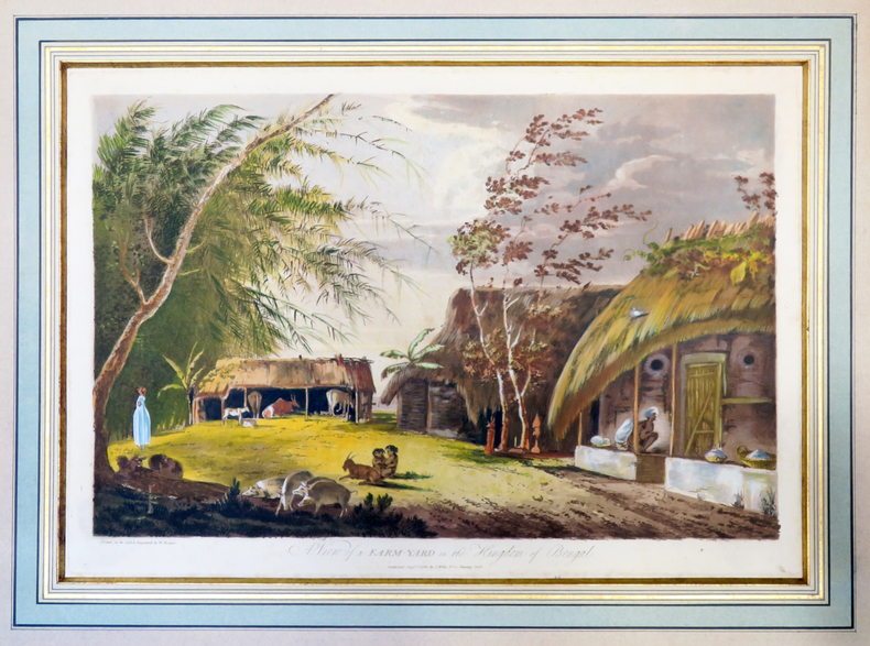
HODGES (William).
A View of a farm-yard in the kingdom of Bengal.
1787. 312 x 452 mm, sous passe-partout.
書籍販売業者の参照番号
: LBW-4003
|
|
|
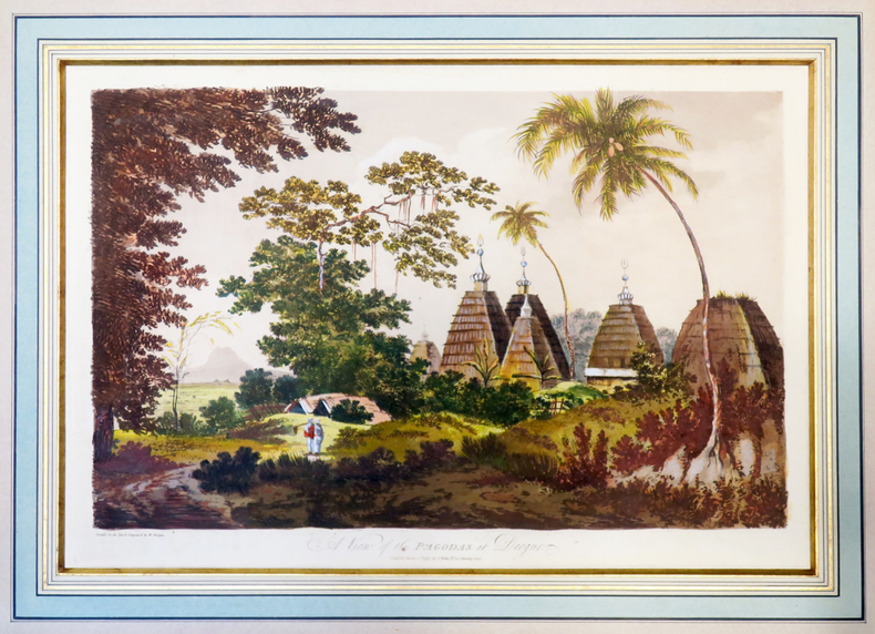
HODGES (William).
A View of the pagodas at Deogur.
1787. 313 x 453 mm, sous passe-partout.
書籍販売業者の参照番号
: LBW-4002
|
|
|
Hodgson William Hope Condensed and with Maps By Dave Hall
The Night Land -by William Hope Hodgson Condensed and with Maps By Dave Hall / The Purple Mouth Press
Virginia : Newport News VA: The Purple Mouth Press 1995 1st edition First Printing 1995. ----------softcover about 7 x 9 inches a Near Fine copy 63 pages b&w maps # 85 of 100 numbered copies of a total edition of 126 any image directly beside this listing is the actual book and not a generic photo. First Edition. Soft Cover. Near Fine see description. Illus. by Text Cover. Newport News, VA: The Purple Mouth Press, 1995, 1st edition, First Printing Paperback
書籍販売業者の参照番号
: 158160

|
|
|
Hodson D.
Portsmouth Record Series: Maps of Portsmouth Before 1801
City of Portsmouth Cartonné avec jaquette 1978 In-4 (21,7 x 30,4 cm), cartonné avec jaquette, 169 pages, texte en anglais ; traces et marques d'usage sur la jaquette inégalement jaunie, rousseurs aux gardes, par ailleurs assez bon état général. Livraison a domicile (La Poste) ou en Mondial Relay sur simple demande.
書籍販売業者の参照番号
: fm583
|
|
|
HOFFBAUER (Fédor).
La Cité entre le Pont Notre-Dame et le Pont au Change (1621).
Paris, Firmin-Didot et Cie, [1875-1882]. 237 x 300 mm.
書籍販売業者の参照番号
: LBW-5818

|
|
|
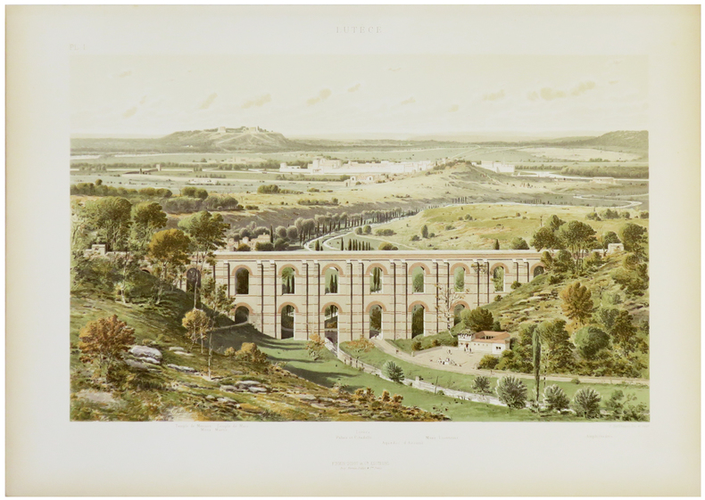
HOFFBAUER (Fédor).
Lutèce.
Paris, Firmin-Didot et Cie, [1875-1882]. 284 x 369 mm.
書籍販売業者の参照番号
: LBW-5821
|
|
|
Hoffman, Ludmila W.
Old Scapes, New Maps - A Training Program for Psychotherapy Supervisors
223 pages including two indeces. Author continues the pursuit of her long standing interest in the education and training of professional psychologists. A valuable resource for instructors of graduate programs in Psychology, Social Work, Psychiatric Nursing, Psychiatry and Counseling. Clean, crisp and unmarked with negligible wear. Excellent copy. Book
|
|
|
Hoffmann, Georg
2 Panoramen des Maderaner-Thales im Kanton Uri. Dazu ein Führer in die Gebirge des Maderaner-Thales. Verfasst von einigen Mitgliedern der Basler Section des schweizerischen Alpenclubs.
Basel, Felix Schneider, 1865. Textheft 54 S. u. 2 lithogr. Panoramen. 43 x 129 cm. + Wichtig: Für unsere Kunden in der EU erfolgt der Versand alle 14 Tage verzollt ab Deutschland / Postbank-Konto in Deutschland vorhanden +
書籍販売業者の参照番号
: 234BG
|
|
|
Hoffmann, Georg:
2 Panoramen des Maderaner-Thales im Kanton Uri. Dazu ein Führer in die Gebirge des Maderaner-Thales. Verfasst von einigen Mitgliedern der Basler Section des schweizerischen Alpenclubs.
Basel, Felix Schneider, 1865. Textheft 54 S. u. 2 lithogr. Panoramen. 43 x 129 cm.
書籍販売業者の参照番号
: 234BG
|
|
|
Hogarth David George; Bartholomew J. G. maps
THE PENETRATION OF ARABIA
New York: Frederick A. Stokes Company 1904. First American Edition. Hardcover. Octavo xiii 359 pages; VG-; bound in publisher's decorated green cloth gilt and black titling to spine; mild wear and rubbing primarily to head of spine and corners; bookplate to ffep; with 54 maps and plates; scarce; LJ consignment; shelved case 8 1/2. Also published in London the same year.;. 1336482. Shelved Dupont Bookstore. Frederick A. Stokes Company hardcover books
書籍販売業者の参照番号
: 1336482

|
|
|
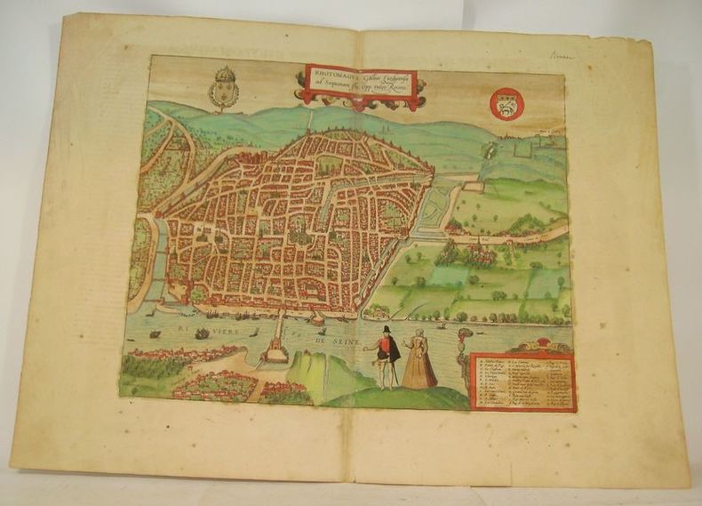
HOGENBERG (Franz).
RHOTOMAGUS Galliae Lugdunensis ad Sequanam Flu. Opp. vulgo Rouen.
Cologne, circa 1590. Gravure à belles marges (40 x 54 cm), rehaussée en couleurs avec texte en latin au dos.
書籍販売業者の参照番号
: 16633
|
|
|
Hohkirchen:
Hohkirchen. "Plan der Bataille, welche d. 14.October 1758 von der Kayserl. Königl. Ungarischen und Kön. Preussischen Armee bei Hohkirchen ohnweit Bauzen geliefert worden." Schlachtenplan von Hohkirchen. Kupferstich mit farbigen Truppenaufstellungen, Legende rechts. der Abbildung aus "Neues Kriegs-Theater", No. 20.
Format: 18 x 29,5 cm. *Leicht gebräunt, insgesamt gut erhalten. Landkarten de
|
|
|
HOLLIER (Antoine Grégoire).
[CRIMÉE/MER d'AZOV] Vue générale de la mer d'Azoff & du détroit de Kertch.
Paris, Hollier, [circa 1856]. 236 x 282 mm.
書籍販売業者の参照番号
: LBW-6517

|
|
|
Holmes Fred L.; Photographs and Maps Illustrator
Alluring Wisconsin the Historical Glamor and Natural Loveliness of an American Commonwealth
E. M. Hale and Company 1938-01-01. 2nd printing. Hardcover. Near Fine. Fine red pebbled boards with gilt lettering on cover and along spine; edges smooth. Binding and hinges tight and square contents clean and unmarked with toning on a few pages. No dust jacket. 480pp. Richly illustrated with period b/w photographs. First edition - second printing. Includes letter to owner from publisher. Additional photos available upon request. All items carefully packed to avoid damage from moisture and rough handling. E. M. Hale and Company hardcover
書籍販売業者の参照番号
: 023840
|
|
|
Holscher Georg. Andrew Mitchell
A Guide To Cologne.
Koln Am Rhein: Hoursch & Bechstedt 1904 circa. 20th Improved edition. Paperback. Good. 16mo 60 iv pages coloured folding map at rear; lower corners of margins of final two leaes of ads torn away; clothbacked pictorial chromolithographed wrappers. Scarce. <br/><br/>This edition has more pages than any other located edition. WorldCat does not cite a copy of this edition but dates the 21st edition to 1906. Thus Koln as it was before both world wars. Note: Uknown No Copy Located Elsewhere. Translated by Andrew Mitchell. Hoursch & Bechstedt paperback
書籍販売業者の参照番号
: 0006848
|
|
|
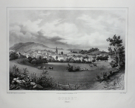
HOLSTEIN;
GUERET (Creuse).
Paris Benard circa 1850 226 x 287 mm.
書籍販売業者の参照番号
: LBW03d65
|
|
|
HOLSTEN - MERCATOR, G. / HONDIUS.
Holsatia ducatus. Per Gerardum Mercatorum privilegio.
(Amsterdam ca. 1607). 35,3x48 cm. Kobberstukket kort over Holsten. Ukoloreret. Velbevaret. På bagsiden latisnk tekst (pp.89-90) Daniae III Tabula, In qua Slesvicensis Ducatus, & Holsatia.
書籍販売業者の参照番号
: 25258
|
|
|
HOLSTEN - MERCATOR, G. / HONDIUS.
Holsatia ducatus. Per Gerardum Mercatorum privilegio.
(Amsterdam ca. 1607). 35,3x48 cm. Kobberstukket kort over Holsten. Ukoloreret. Velbevaret. På bagsiden latisnk tekst (pp.89-90) Daniae III Tabula, In qua Slesvicensis Ducatus, & Holsatia.
|
|
|
HOLY LAND MAPS
Ancient Maps of the Holy Land. Israel. Cartes Anciennes de la Terre Sainte. Atlas Vetus Terrae Sanctae.
Jerusalem Israel.: The Universitas Booksellers of Jerusalem Israel. 1958. 9 double page hand colored maps loosely inserted into a portfolio measuring 19 x 13 3/4 inches. Portfolio is paper-covered boards hardbound with pictorial dust jacket. Double page text sheet with description of maps IN FRENCH. Maps and portfolio are all in very good condition. Dust jacket has three 3-4 inch tears and light creasing light discoloration at the lower edge but otherwise good condition. This is number 190 of a special edition deluxe with hand colored reproductions. An unusual and attractive item. Maps are as follows: 1. La Palestine dans "L'Ancienne Carte de la Route"; 2. Carte de la Terre Sainte de Pietro Vesconte; 3. Carte de la Terre Sainte. Lubeck 1475; 4. Carte Generale de la Palestine 1530; 5. La Terre Sainte Divisee d'apres les Tribus d'Israel. Bale 1544. 6. Carte Geographique d'Israel. Anvers 1571. 7. Le Pays de la Bible a L'Epoque Romaine. Londres 1576. 8 Terra Sancta La Terre sainte ou Palestine. Anvers 1584. 9. La Terre Sainte. Ou La terre Promise anciennement Palestine. Amsterdam 1629. . The Universitas Booksellers of Jerusalem (Israel). hardcover
書籍販売業者の参照番号
: 30363

|
|
|
HOLZER HANS; FRERICHS NATHAN C. S. ILLUSTRATIONS; ALLEN DAVID MAPS; WOOD CATHERINE SUPPLEMENTARY RESEARCH
Hans Holzer's Travel Guide To Haunted Houses
Black Dog & Leventhal Publishers New York: 1998. Hardcover with dustjacket. Very good condition. A practical guide to places haunted by ghosts poltergeists and spirits. Includes lists for 101 haunted places in North America and Europe. ISBN: 1579120164. Black Dog & Leventhal Publishers, New York: 1998 hardcover
書籍販売業者の参照番号
: 16331X1 ISBN : 1579120164 9781579120160
|
|
|
Holzer - Reilly, Franz Johann Joseph von
Special-Karte von dem Oestreichischen u. Osmanischen Koenigreiche Kroatien. Teilkolorierte Kupferstichkarte (No. 2) aus "Schauplatz der fünf Theile der Welt".
Wien, Reilly, ca. 1789. 22 x 29 cm (Blattgröße 24 x 32 cm).
書籍販売業者の参照番号
: 110616

|
|
|
Holzman, Jacquelin; McQuarrie, John; Tosh, Rosalind
Ottawa, Then and Now
No marks or inscriptions. A lovely clean very tight copy with bright unmarked boards and no bumping to corners. Dust jacket not price clipped or marked or torn with slight creasing to edges and traces of storage. 208pp. Ottawa from her birth to the present day in very well captioned photographs. Scarce in the UK.

|
|
|
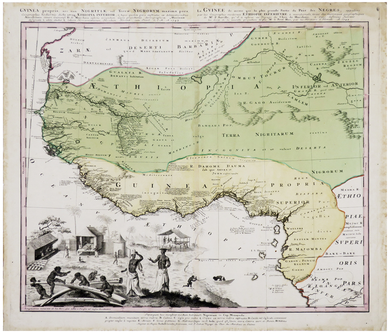
HOMANN (Héritiers de).
[GUINÉE] Guinea propria, nec non Nigritiæ vel Terræ Nigrorum maxima pars, geographis hodiernis dicta utraque Æthiopia inferior - La Guinée de même que la plus grande partie du Pais des Nègres, appellées par les géographes modernes Éthiopie inférieure & méridionale.
Nuremberg, Homann Héritiers, 1745. 493 x 552 mm.
書籍販売業者の参照番号
: LBW-6411
|
|
|
HOMANN (Héritiers de).
[PANAMA] Portus Pulchri in Isthmo Panamensi - Scenographia Portus Pulchri.
[Nuremberg], Homann Héritiers, 1740. 480 x 282 mm.
書籍販売業者の参照番号
: LBW-5884

|
|
|
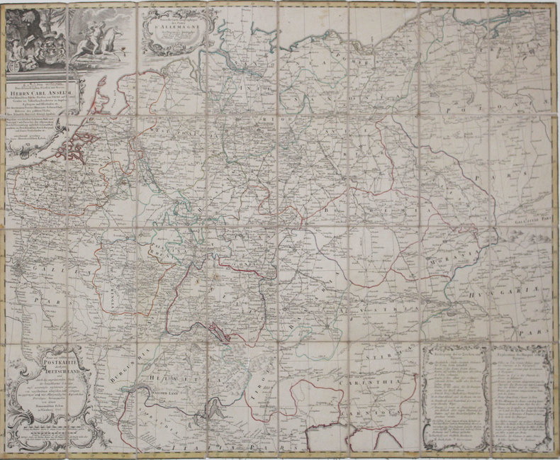
HOMANN (Héritiers de).
[POSTES] Nouvelle carte géographique des postes d'Allemagne - Neue und vollstændige Postkarte durch ganz Deutschland.
Nuremberg, Héritiers de Homann, 1786. En 32 sections montées sur toile et pliées, formant une carte de 776 x 968 mm.
書籍販売業者の参照番号
: LBW-4318
|
|
|
HOMANN (Héritiers de);
[CROATIE/BOSNIE/SERBIE] Regnum Bosniae, una cum finitimis Croatiae, Dalmatiae, Slavoniae, Hung. et Serviae partibus - Regni Serviae pars, una cum finitimis Valachiae & Bulgariae.
Nuremberg vers 1740 En 4 feuilles jointes de 605 mm x 1,11 m, dont une partie mobile de 310 x 185 mm.
書籍販売業者の参照番号
: LBW-1799

|
|
|
HOMANN (Jean-Baptiste)
[Carte géographique]. Ducatus Luxemburgi tam in Maiores quàm Minores eiusdem ditiones accurate distinctus et exhibitus.
Nuremberg, Homann, (c.1720). 58,4 x 48,6 cm + marges.
書籍販売業者の参照番号
: 14260
|
|
|
HOMANN (Jean-Baptiste)
[Carte géographique]. Ducatus Pomeraniae novissima tabula anteriorem et interiorem divisa, quatenus subsunt coronis Sueciae et Borussiae...
Nuremberg, Homann, (c.1720). 58,5 x 50 cm à la cuvette + marges.
書籍販売業者の参照番号
: 14259
|
|
|
HOMANN (Jean-Baptiste)
[Carte géographique]. Principatus Isenacensis cum adjacentibus vicinorum Statuum.
Nuremberg, Homann, (c.1720). 57 x 50 cm à la cuvette + marges.
書籍販売業者の参照番号
: 14258
|
|
|
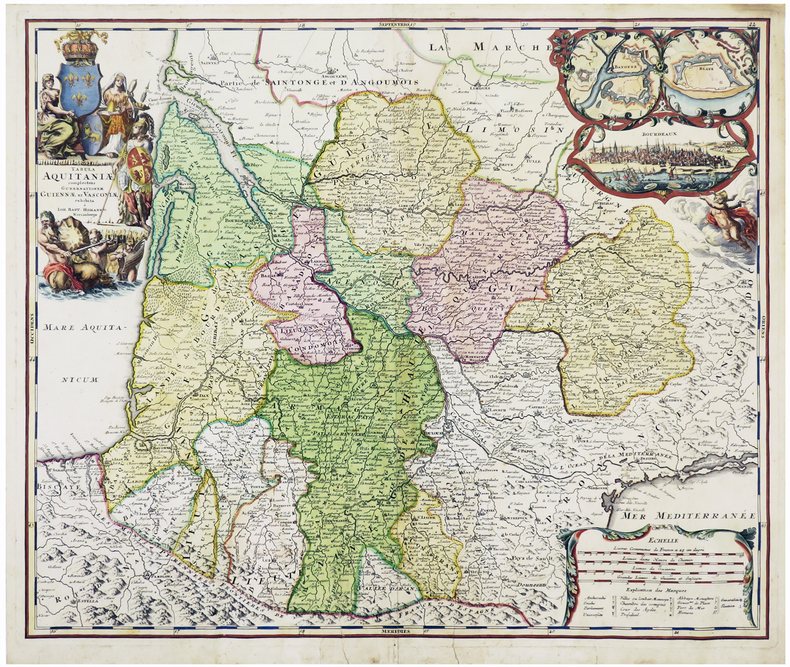
HOMANN (Johann Baptist).
[AQUITAINE] Tabula Aquitaniæ complectens gubernationem Guiennæ et Vasconiæ exhibita.
Nuremberg, [circa 1720]. 478 x 570 mm.
書籍販売業者の参照番号
: LBW-6109
|
|
|
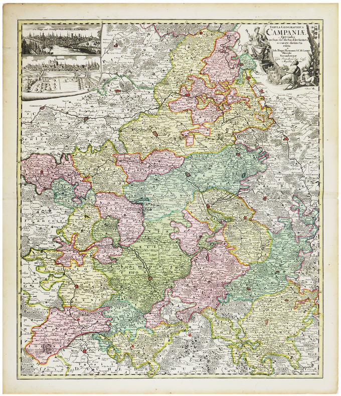
HOMANN (Johann Baptist).
[CHAMPAGNE] Tabula geographica specialis in suas sic dictas electiones accurate distincta edita.
Nuremberg, [circa 1720]. 574 x 488 mm.
書籍販売業者の参照番号
: LBW-6259
|
|
|
HOMANN (Johann Baptist).
[PAVILLONS] Flaggen aller Seefahrenden Potenzen und Nationen in der gantzen Weldt.
Nuremberg, [circa 1720]. 495 x 587 mm.
書籍販売業者の参照番号
: LBW-4462

|
|
|
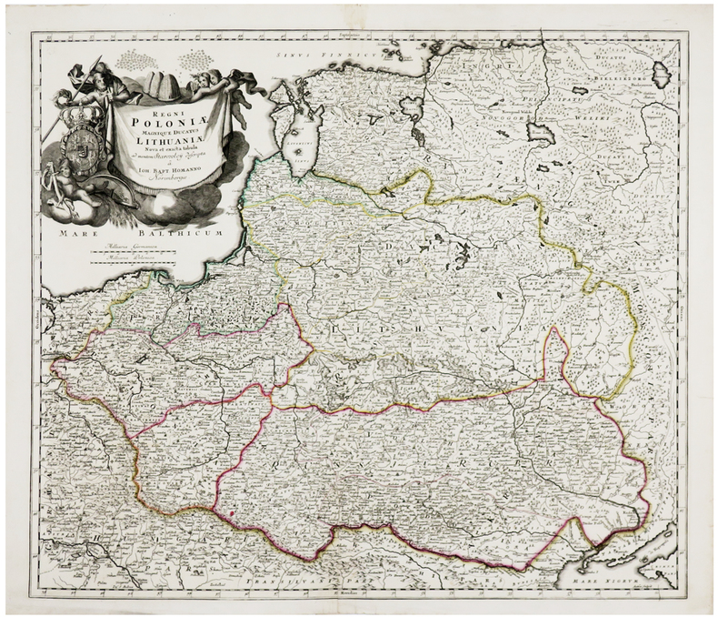
HOMANN (Johann Baptist).
[POLOGNE/LITUANIE] Regni Poloniæ magnique Ducatus Lithuaniæ.
Nuremberg, [circa 1710]. 492 x 568 mm.
書籍販売業者の参照番号
: LBW-6237
|
|
|
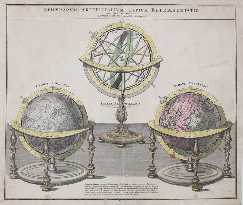
HOMANN (Johann Baptist).
[SPHÈRES] Sphærarum artificialium typica repræsentatio.
Nuremberg, 1720. 483 x 571 mm.
書籍販売業者の参照番号
: LBW-3192
|
|
|
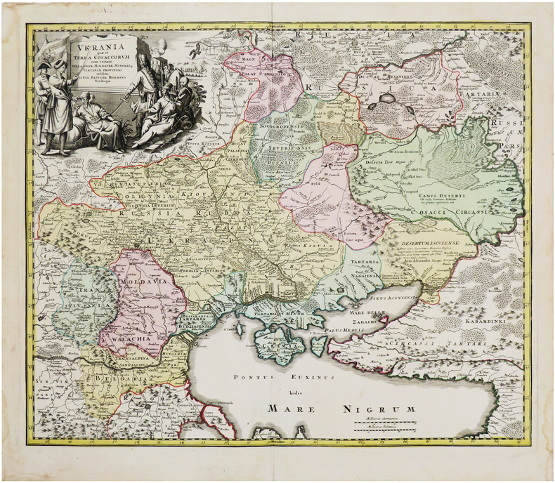
HOMANN (Johann Baptist).
[UKRAINE] Ukrania quæ et terra Cosaccorum cum vicinis Walachiæ, Moldaviæ, Minoris Tartariæ provinciis exhibita.
Nuremberg, [1729]. 481 x 576 mm.
書籍販売業者の参照番号
: LBW-6542
|
|
|
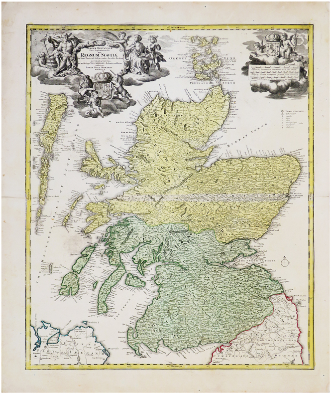
HOMANN (Johann Baptist).
[ÉCOSSE] Magnæ Britanniæ pars septentrionalis qua regnum Scotiæ.
Nuremberg, [circa 1730] 574 x 478 mm.
書籍販売業者の参照番号
: LBW-6539
|
|
|
HOMANN (Johann Baptist).
Accurater Grundriss u: Gegend der Koenigl. Gross-Brittanischen Haupt und Residentz-Stadt London.
Nuremberg, [circa 1730]. 489 x 580 mm.
書籍販売業者の参照番号
: LBW-680
|
|
|
HOMANN (Johann Baptist);
[METZ] Accurata rapraesentatio ichnographica urbis episcopalis in Ducatu Lotharingiae, dictae Metae.
Nuremberg 1739 470 x 556 mm.
書籍販売業者の参照番号
: LBW-403

|
|
|
HOMANN (Successeurs)
ATLAS NOVUS REIPUBLICAE HELVETICAE XX MAPPIS COMPOSITUS SUMTIBUS HOMANNIANIS HEREDIBUS.
1769 Nuremberg, 1769. 33x52,5 cm. Recueil de 20 grandes cartes de la Suisse sur double pages, en couleurs ! Augmenté d'une carte de Neuchâtel et Valangin dressée en 1778. Reliure de la fin du XVIIIème siècle ou du début du XIXème siècle en demi-basane à petits coins. Plats recouverts de papier beige moucheté. Dos lisse orné de bandes dorées. Titre sur pièce de couleur orangée. Petites traces d'usage sur la reliure et papier très légèrement bruni par endroit, sinon ouvrage en excellent état et complet, ce qui est exceptionnel !
書籍販売業者の参照番号
: 1564
|
|
|
HOMANN Eredi Johannes Baptiste (1730 - 1813)
Neue Welt Karte
Carta geografica de l mondo inserita nell'atlante degli eredi della tipografia Homann. Dal punto di vista cartografico la mappa presenta diverse innovazioni ed aggiornamenti, soprattutto nel Pacifico dove sono mostrate le scoperte di Cook del 1770. I Grandi Laghi si presentano come un unico enorme specchio d'acqua e la California ha una forma strana, con la Baja che sembra quasi un'isola. L'Australia comprende diversi toponimi sulla costa orientale, frutto delle scoperte di Cook nel 1770. Tuttavia, l'isola di Van Diemens è ancora mostrata collegata alla terraferma. Sono disegnate le rotte di diverse esplorazioni della fine del XVIII secolo. Johann Baptist Homann è stato un geografo e cartografo tedesco; nel 1702 fondò la sua casa editrice. Homann acquisì fama come uno dei principali cartografi tedeschi, e nel 1715 fu nominato geografo imperiale dall'imperatore Carlo VI. Nello stesso anno fu anche nominato membro dell'Accademia Prussiana delle Scienze a Berlino. Nel 1716 Homann pubblicò il suo capolavoro Grosser Atlas ueber die ganze Welt. Numerose mappe furono redatte in collaborazione con l'incisore Christoph Weigel. Homann morì a Norimberga nel 1724. Gli successe suo figlio Johann Christoph (1703-1730). L'azienda continuò dopo la sua morte come azienda degli eredi Homann, gestita da Johann Michael Franz e Johann Georg Ebersberger. Dopo successivi cambiamenti nella gestione, l'azienda si sciolse nel 1852. Incisione in rame, finemente colorata a mano, in ottimo stato di conservazione. This interesting world map presents some curious cartography, given the date of the map. The Great Lakes are shown as one huge body of water and California is strangely shaped with the Baja nearly appearing as an island. Australia includes several place names on the eastern coast, which resulted from Cook's discoveries in 1770. However, Van Diemens Land is still shown connected to the mainland. The tracks of several late 18th century expeditions are shown. Color key and German text panel below the hemispheres. Johann Baptist Homann was a German geographer and cartographer; in 1702 he founded his own publishing house. Homann acquired renown as a leading German cartographer, and in 1715 was appointed Imperial Geographer by Emperor Charles VI. In the same year he was also named a member of the Prussian Academy of Sciences in Berlin. In 1716 Homann published his masterpiece Grosser Atlas ueber die ganze Welt; numerous maps were drawn up in cooperation with the engraver Christoph Weigel the Elder. Homann died in Nuremberg in 1724 and was succeeded by his son Johann Christoph (1703-1730). The company carried on upon his death as Homann heirs company, managed by Johann Michael Franz and Johann Georg Ebersberger. After subsequent changes in management the company folded in 1852. Etching with fine later hand colour, very good condition.

|
|
 検索結果のメールを受信する
 PDFファイルの検索結果をダウンロード
 RSSフィード


