|
Miquelon, Dale; Ingram, George C.; Morrison, William R.;
Canadian Historic Sites - Occasional Papers in Archaeology and History No. 4
188 pages. Includes the following papers: A Brief History of Lower Fort Garry; The Big House, Lower Fort Garry; Industrial and Agricultural Activities at Lower Fort Garry; The Sixth Regiment of Foot at Lower Fort Garry; The Second Battalion, Quebec Rifles, at Lower Fort Garry. Includes a variety of black and white illustrations and maps. Unmarked. Moderate wear. Book
|
|
|
Miro Joan, Philippi Simone (présentation):
Postcard book - Miro.
Taschen, 1993. In-12, cartonnage illustré. Texte introductif agrémenté de photographies en noir, suivi des 30 cartes postales avec des reproductions de l'artiste, détachables. Bien complet bien sûr.
Bookseller reference : 5650

|
|
|
Mirsky Jeanette; Maps & Illustrations Illustrator
The Great Chinese Travellers
George Allen & Unwin 1/1/1965. Hardcover. Very Good. Hardcover and dust jacket. Good binding and cover. Shelfwear. Clean unmarked pages. Ships daily. George Allen & Unwin hardcover
Bookseller reference : 1305220028
|
|
|
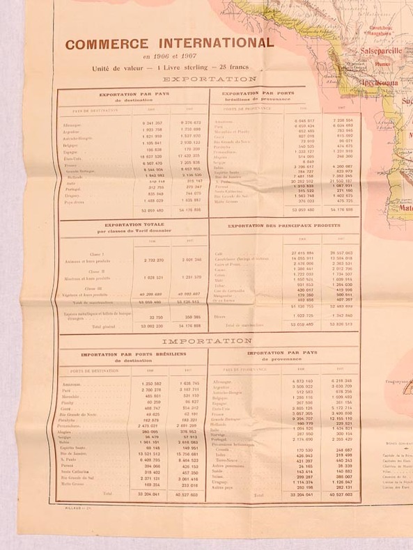
Mission Brésilienne d'Expansion Economique
Brésil. Carte Politique et Economique [ Commerce International en 1906 et 1907 ]
Carte politique et économique publiée par la Mission brésilienne d'Expansion économique, échelle au 1 : 5 000 000, 1 carte format 83,5 x 90 cm, Aillaud & Cie, s.d. [ circa 1908 ]
Bookseller reference : 59450
|
|
|
MISSIONS FRANCISCAINES.
Le voyage du missionnaire.
Vanves, Imp. Franciscaine, [vers 1930]. 377 x 465 mm ; entoilé et monté sur carton, en trois volets dépliants.
Bookseller reference : LBW-8574

|
|
|
Mission Brésilienne d'Expansion Economique
Brésil. Carte Politique et Economique [ Commerce International en 1906 et 1907 ]
Carte politique et économique publiée par la Mission brésilienne d'Expansion économique, échelle au 1 : 5 000 000, 1 carte format 83,5 x 90 cm, Aillaud & Cie, s.d. [ circa 1908 ] Belle carte politique et économique du Brésil à l'aube de la Première Guerre Mondiale. Bon état (qq. très petits frott., très bon état par ailleurs). Français

|
|
|
Mitchell John D.; Gerke Margaret Maps and Titls
Lost Mines & Buried Treasures: Along the Old Frontier
Palm Desert California: Desert Magazines Press 1958. 234 Pages Indexed. This is the July 1958 Second Printing. Front board has light wear to edges and corners Front endpaper has map showing 38 locations over the Southwest and an inset showing five locations in Texas Mexico and Oregon. Gift inscriptions on the half-title page from loving daughters to their father on father's day. No other marks. The fact that the old mines and treasures referred to have not been re-located has not prevented the author from giving important details as to their value and general location. Many of the details have been taken from original Spanish documents and church records from the words of old Indians whose ancestors had worked in the mines and of old-timers who themselves had lost once-in-a-lifetime strikes or knew prospectors who had. The author has spent many years in the desert mountains and on the boundless plains of Old Mexico and the American Southwest. His life has been cast along with these old stories in the days when the old-timers lived and searched for gold. He has spent many pleasant hours around campfires listening to the tales and traditions of by-gone days. Everyone dreams of finding buried riches. Many volumes of fiction have been written about the buried booty of t he pirates who once sailed the seas. But this book is about treasure which is known to have existed and which the old-timers insist will still be found. Here are the clues the writer has gathered in his years in the Desert Southwest. This is not a book fiction. But those who hunt for these long lost fortunes should be cautious. They should heed the warning of whitened skulls of lost trails and empty canteens. . Second Printing. Hard Back. Very Good/No Dust Jacket. Illus. by Hansen John - Illustrator. 6 1/4" X 9 1/4". Desert Magazines Press
Bookseller reference : 20398

|
|
|
Mitscherlich, E.:
Geognostische Karte der vulkanischen Eifel. Farbige lithographische Karte von E. Mitscherlich.
48,5 x 59 cm. *Frühe Karte der geognostischen Erscheinungen der Eifel. - Zeigt das Gebiet zwischen Ormont, Jammelhoven, Beuren, und St. Thomas. Aus Mitscherlichs Werk: "Über die vulkanischen Erscheinungen in der Eifel". Mehrfache Falzspuren. Graphiken de
|
|
|
Mittelbach
Mittelbachs Karten: Amiens-Abbeville-St. Pol. - Blatt 2
Approximately 23" x 19". Undated but probably from the early 20th century. Clean and unmarked with light wear. Some age-toning. A quality copy. Map

|
|
|
Mittelbach
Mittelbachs Karten: Arras - Cambrai - Peronne - Laon - St. Quentin, Blatt 3
Approximately 23" x 19". Undated but probably from the early 20th century. Bit of writing on bottom edge of map. Moderate wear. Some age-toning. A sound copy. Map

|
|
|
Mittelbach
Mittelbachs Karten: Paris - Compiegne Soissons - Chateau - Thiery, Blatt 4
Approximately 23" x 19". Undated but probably from the early 20th century. Unmarked with moderate wear. Some age-toning. A sound copy. Map

|
|
|
Mittelman Joseph B./Reed Lawrence maps/art
Eight Stars to Victory: A History of the Veteran Ninth U.S. Infantry Division
Washington: Ninth Infantry Division Association 1948. later reprint. VG/no dust jacket. 407 p. photos maps maps on pastedowns 4to later printing photos/maps/text have appearance of copies of original pages; Ninth Infantry Division Association hardcover
Bookseller reference : 66427

|
|
|
Mittelman Joseph B./Reed Lawrence maps/art
Eight Stars to Victory: A History of the Veteran Ninth U.S. Infantry Division
Washington: Ninth Infantry Division Association 1948. 1st printing. VG/no dust jacket. 407 p. photos maps maps on endpapers 4to; Ninth Infantry Division Association hardcover
Bookseller reference : 30140
|
|
|
Mittelman Joseph B./Reed Lawrence maps/art
Eight Stars to Victory: A History of the Veteran Ninth U.S. Infantry Division
Washington: Ninth Infantry Division Association 1948. 1st printing. VG/no dust jacket. 407 p. photos maps maps on endpapers 4to; Ninth Infantry Division Association hardcover
Bookseller reference : 30139
|
|
|
Mitton Jacqueline; Balit Christina illustrator; Tirion Wil star maps.
Zoo in the Sky: A Book of Animal Constellations.
Sydney Mascot: Koala Book Company 1998. 1st Australian ed. Hardback oblong quarto pictorial cover illustrated endpapers very good condition colour drawings few light creases last page minimal edgewear. Unnum 24 pp. A children's picture book being a magical tour of the skies featuring 19 constellations named after animals birds and fishes. The poetic text supplemented by sky maps and background information about the stars combines with the beautiful incandescent paintings to create a book that will fascinate children of all ages. Koala Book Company hardcover
Bookseller reference : 26621 ISBN : 0864611374 9780864611376
|
|
|
Mme de B.
Les patiences. Passe-temps récréatifs. Nouveau recueil complet.
Genève et Paris, éditions Cherbuliez 1867. Exemplaire broché (18x12), couverture usagée (manque 1 plat), 146 pages avec table.
Bookseller reference : AUB-1555
|
|
|
Moats Leone and Moats Alice Leone; Maps By Matias Santoyo Illustrator
Off to Mexico
Charles Scribner's Sons 1935-01-01. First Edition. Hardcover. Good/Missing. First edition with Scriber's A on copyright page. Spine and top of front and back cover sunned. General wear but text is clean and binding is sound. From the collection of Pulitzer nominated historian Gloria Grace Griffen whose bookplate is adhered to front paste down. Charles Scribner's Sons hardcover
Bookseller reference : GGGmoaOTM
|
|
|
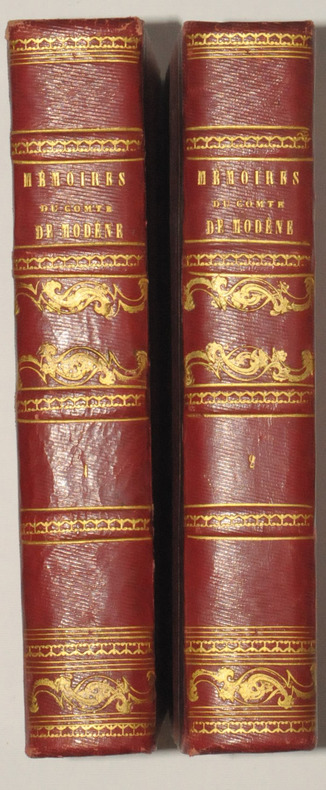
MODENE (Comte de).
Mémoires du Comte de MODENE, sur la Révolution de Naples de 1647. Troisième édition, publiée par J. - B. MIELLE.
Paris, Chez Félicien et Chatel, 1827. 2 volumes in-8, demi-chagrin rouge, dos ornés de filets dorés, 270 et 514 pages.
Bookseller reference : 7488
|
|
|
MODENE (Comte de).
Mémoires du Comte de MODENE, sur la Révolution de Naples de 1647. Troisième édition, publiée par J. - B. MIELLE.
Paris, Chez Félicien et Chatel, 1827. 2 volumes in-8, demi-chagrin rouge, dos ornés de filets dorés, 270 et 514 pages. Belle édition malgré une légère insolation sur les plats.
|
|
|
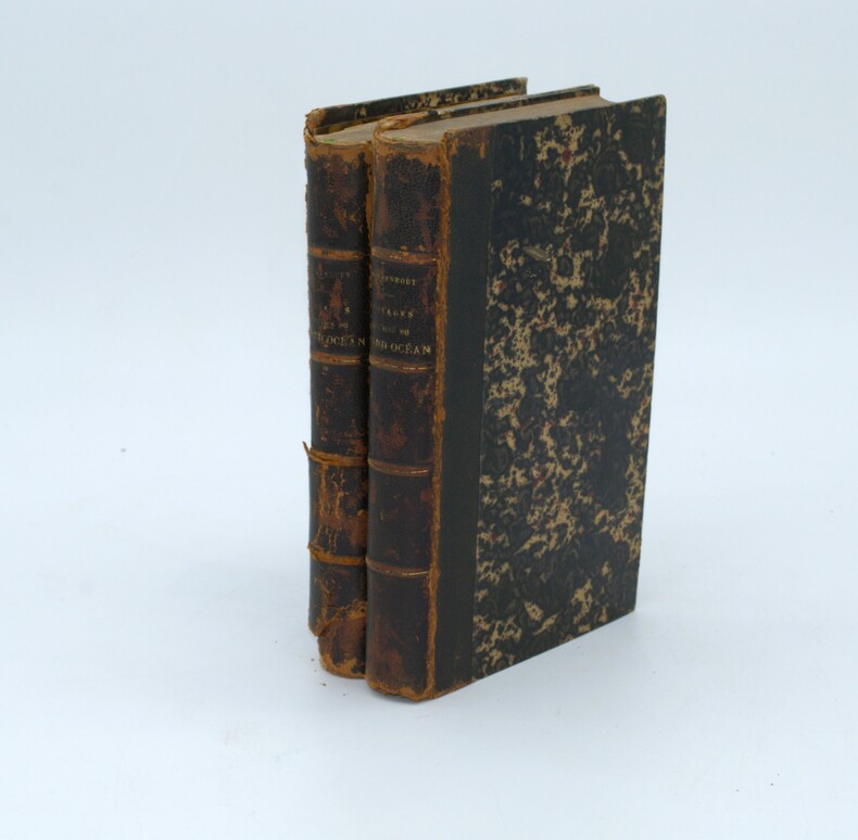
MOERENHOUT , J. A.
Voyages aux îles du Grand Océan, contenant des documents nouveaux sur la géographie physique et politique, la langue, la littérature, la religion, les moeurs, les usages et les coutumes de leurs habitants et considérations générales sur leur commerce, leur histoire et leur gouvernement depuis les temps les plus reculés jusqu'à nos jours.
Paris, A. Bertrand, 1837. 2 volumes in-8 (21,5x13,5 cm) , xv, [1], 576; [4], 520, vii pp. ,illustré de 4 gravures et une carte dépliante , relié demi cuir époque , défauts de reliure , frottements aux charnières , les plats du tome 2 sont détachés , coiffes usées et manque au dos tome 2 , cachets répétés , quelques rousseurs et brunissures
Bookseller reference : PHO-1439
|
|
|
Moffat, Alistair
Edinburgh
No marks or inscriptions. No creasing to covers or to spine. A very clean very tight copy with bright unmarked boards and bumping to lower rear corner. 176pp. Essentially a book of lovely photographs presenting an up-to-date picture of the Scottish capital accompanied by a short history.

|
|
|
Moffat, Alistair
Fife
No marks or inscriptions. No creasing to covers or to spine. A very clean very tight copy with bright unmarked boards and extremely minor bumping to spine top and lower rear corner. 176pp. Essentially a book of lovely photographs presenting an up-to-date picture of the Scottish region of Fife between the Forth and the Tay accompanied by a short history.

|
|
|
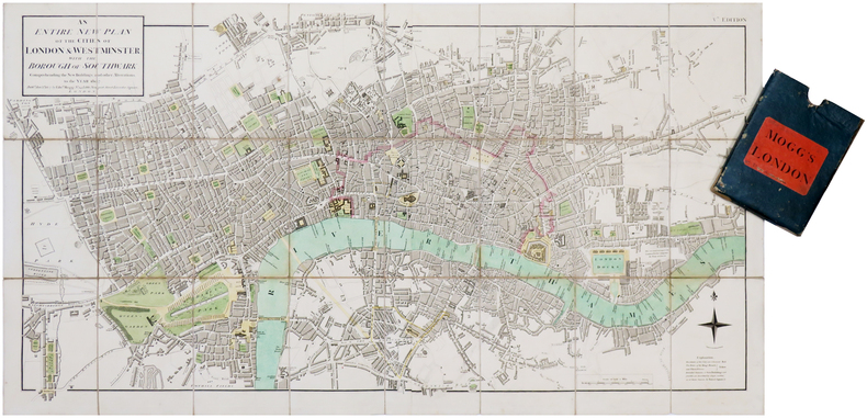
MOGG (Edward).
[LONDRES] An entire new plan of the cities of London & Westminster; with the borough of Southwark: comprehending the new buildings and other alterations, to the year 1807.
London, Edw.d Mogg, 1807. En deux feuilles coupées en 24 sections montées sur toile et pliées, formant une carte de 482 x 906 mm ; étui de papier bleu de l'époque avec pièce de titre de papier rouge.
Bookseller reference : LBW-7019
|
|
|
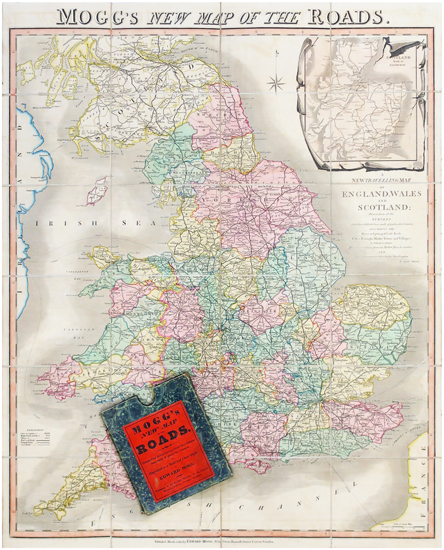
MOGG (Edward).
Mogg's new map of the roads - A new travelling map of England, Wales and Scotland.
Londres, Edward Mogg, 1830. En 24 sections montées sur toile et pliées, formant une carte de 770 x 630 mm ; sous étui de papier marbré vert de l'éditeur.
Bookseller reference : LBW-6506
|
|
|
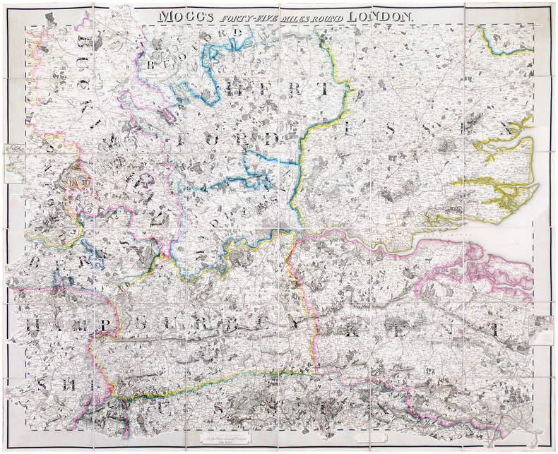
MOGG (Edward).
Mogg's forty-five miles round London.
London, Edward Mogg, June 1st 1821. En 36 sections montées sur toile et pliées, formant une carte de 0,96 x 1,16 m ; étiquette au dos de l'éditeur et marchand de cartes Charles Smith, actif entre 1800 et 1822.
Bookseller reference : LBW-6491
|
|
|
MOGALLI Niccolò- PETROSCHI Giovanni
Carta topografica delle Antichità di Roma…secondo il Giro metodico usato già dall'AB. Ridolfino Venuti…
Pianta topografica delle vestigia dell'antica Roma, a proiezione e figurazione verticale, pubblicata nel 1763 nell'opera di Ridolfino Venuti "Accurata, e succinta descrizione topografica delle antichità di Roma".Incisa da Niccolò Mogalli e Giovanni Petroschi, su disegno di R. Venuti.Le indicazioni toponomastiche in parte sono riportate nella pianta, in parte in una rubrica di 77 numeri posta ai lati. In basso, a destra, la firma degli incisori. La seconda edizione della lastra, reca la data 1823.Incisione su rame, in ottimo stato di conservazione. Pianta topografica delle vestigia dell'antica Roma, a proiezione e figurazione verticale, pubblicata nel 1763 nell'opera di Ridolfino Venuti "Accurata, e succinta descrizione topografica delle antichità di Roma".Incisa da Niccolò Mogalli e Giovanni Petroschi, su disegno di R. Venuti.Le indicazioni toponomastiche in parte sono riportate nella pianta, in parte in una rubrica di 77 numeri posta ai lati. In basso, a destra, la firma degli incisori. La seconda edizione della lastra, reca la data 1823.Incisione su rame, in ottimo stato di conservazione. Frutaz, Le piante di Roma, XXXVIII; L. Schudt, Le guide di Roma, p. 405, n. 769; Caldana (2013): p. 107, n. I.64.

|
|
|
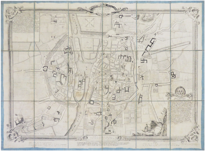
MOITHEY (Maurille-Antoine).
[ANGERS] Plan historique de la ville d'Angers, assujetti à ses accroissements, embellissements et projets.
Paris, S.r Moithey, 1792. En 18 sections montées sur toile bleue et repliées, formant un plan de 428 x 572 mm.
Bookseller reference : LBW-7835
|
|
|
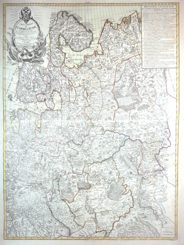
MOITHEY (Maurille-Antoine).
Carte générale de l'empire de Russie comprise en Europe.
Paris, Crépy, 1788. En 2 feuilles jointes de 870 x 647 mm.
Bookseller reference : LBW-3426
|
|
|
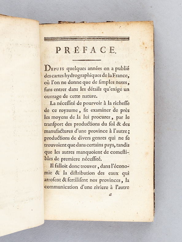
MOITHEY, M. ; [ MOITHEY, Maurille-Anthoine ]
Dictionnaire hydrographique de la France [ Edition originale ] Ou nomenclature des Fleuves, Rivières, Ruisseaux et Canaux ; le lieu où ils prennent leurs sources, leurs embouchures et confluents, leur étendue eû égard à leurs sinuosités, leur commerce flottable ou navigable avec les villes qu'ils arrosent, suivie d'une division hydrographique de ce royaume et d'une description de ses ports &c. enrichie d'une carte de la France relative à l'objet
1 vol. in-8 reliure de l'époque demi-basane marron, Chez L'auteur et Chez Prevost, Le Roi, Paris, 1787, 2 ff., VIII-221 pp. 1 f., 4 pp. avec une grande carte dépliante en couleurs (format 58 x 510 cm) Titre complet : Dictionnaire hydrographique de la France [ Edition originale ] Ou nomneclature des Fleuves, Rivières, Ruisseaux et Canaux ; le lieu où ils prennent leurs sources, leurs embouchures et confluents, leur étendue eû égard à leurs sinuosités, leur commerce flottable ou navigable avec les villes qu'ils arrosent, suivie d'une division hydrographique de ce royaume et d'une description de ses ports &c. enrichie d'une carte de la France relative à l'objet
Bookseller reference : 57377
|
|
|
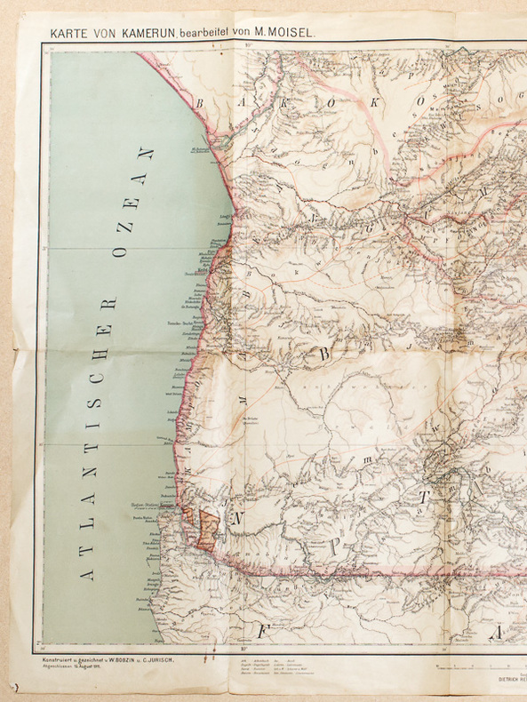
MOISEL, Max
Karte von Kamerun, bearbeitet von M. Moisel H 1 , 2 : Kribi [ Echelle 1 / 300.000 ]
1 carte dépliante format 64 x 99,5 cm, Konstruiert u. gezeichnet v. W. Bobzin u. C. Jurisch. Abgeschlossen 15 August 1911
Bookseller reference : 47969
|
|
|
MOISEL, Max
Karte von Kamerun, bearbeitet von M. Moisel H 1 , 2 : Kribi [ Echelle 1 / 300.000 ]
1 carte dépliante format 64 x 99,5 cm, Konstruiert u. gezeichnet v. W. Bobzin u. C. Jurisch. Abgeschlossen 15 August 1911 Carte allemande de 1911, couvrant le territoire allant de Kribi à Sangmélima. Etat très satisfaisant (petits accrocs en marge). Français

|
|
|
MOITHEY, M. ; [ MOITHEY, Maurille-Anthoine ]
Dictionnaire hydrographique de la France [ Edition originale ] Ou nomenclature des Fleuves, Rivières, Ruisseaux et Canaux ; le lieu où ils prennent leurs sources, leurs embouchures et confluents, leur étendue eû égard à leurs sinuosités, leur commerce flottable ou navigable avec les villes qu'ils arrosent, suivie d'une division hydrographique de ce royaume et d'une description de ses ports &c. enrichie d'une carte de la France relative à l'objet
1 vol. in-8 reliure de l'époque demi-basane marron, Chez L'auteur et Chez Prevost, Le Roi, Paris, 1787, 2 ff., VIII-221 pp. 1 f., 4 pp. avec une grande carte dépliante en couleurs (format 58 x 510 cm) Titre complet : Dictionnaire hydrographique de la France [ Edition originale ] Ou nomneclature des Fleuves, Rivières, Ruisseaux et Canaux ; le lieu où ils prennent leurs sources, leurs embouchures et confluents, leur étendue eû égard à leurs sinuosités, leur commerce flottable ou navigable avec les villes qu'ils arrosent, suivie d'une division hydrographique de ce royaume et d'une description de ses ports &c. enrichie d'une carte de la France relative à l'objet Cette édition originale est bien complète de la belle grande carte en couleurs intitulée : "Carte Physique et Hydrographique de la France ou l'on trouve les principales Chaînes de Montagnes, le cours des Fleuves de France et de toutes les Rivières qui y affluent, avec l'indication des lieux ouelles sont navigables, les Canaux existans ; les Villes riveraines, les Ports et les principaux Ponts, Divisée en ses Gouvernemens et Provinces, dressée d'après la Carte générale de France de l'Académie". Etat satisfaisant (reliure très fort. usée, cachet ancien de séminaire, très bon état intérieur). Ingénieur géographe du Roi et professeur de mathématiques des pages du Prince et de la Princesse de Conti, Maurille-Anthoine Moithey (1732-1805) se fit libraire et éditeur pour diffuser plusieurs travaux géographiques et cartographiques. Français

|
|
|
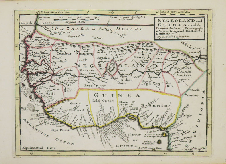
MOLL (Herman).
[AFRIQUE de l'OUEST] Negroland and Guinea with the European settlement, explaining what belongs to England, Holland, Denmark &c.
[Londres], Thomas and John Bowles, [circa 1736]. 204 x 275 mm.
Bookseller reference : LBW-3565
|
|
|
MOLL (Herman).
[BERMUDES] The Island of Bermudos divided into its tribes, with the castles, forts &c.
Londres, Thomas and John Bowles, [circa 1736]. 203 x 270 mm.
Bookseller reference : LBW-3559

|
|
|
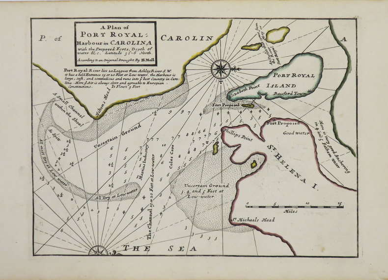
MOLL (Herman).
[CAROLINE du SUD] A Plan of Port Royal harbour in Carolina with the proposed forts, depth of water &c.
Londres, Thomas and John Bowles, [circa 1736]. 200 x 270 mm.
Bookseller reference : LBW-3563
|
|
|
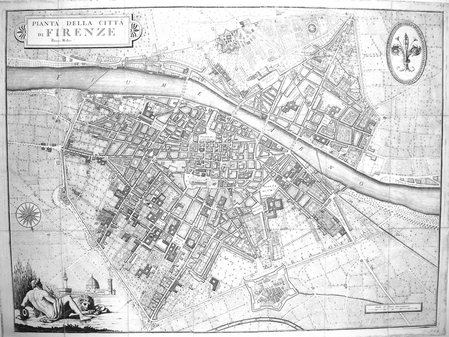
MOLINI (Giuseppe);
[FLORENCE] Pianta della città di Firenze. Presso Molini.
Firenze Molini 1847 En 21 sections jointes formant un plan de 505 x 678 mm.
Bookseller reference : LBW0028f
|
|
|
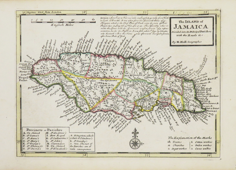
MOLL (Herman).
[JAMAÏQUE] The Island of Jamaica.
Londres, Thomas and John Bowles, [circa 1736]. 200 x 275 mm.
Bookseller reference : LBW-3541
|
|
|
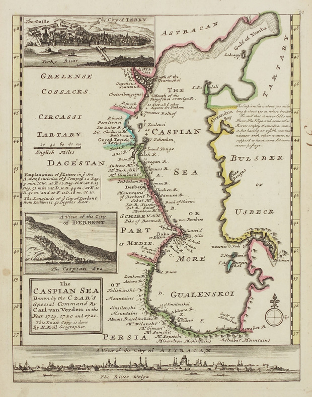
MOLL (Herman).
[MER CASPIENNE] The Caspian sea drawn by the Czar's special command by Carl van Verden in the year 1719, 1720 and 1721.
[Londres, Thomas and John Bowles, circa 1736]. 262 x 205 mm.
Bookseller reference : LBW-2913
|
|
|
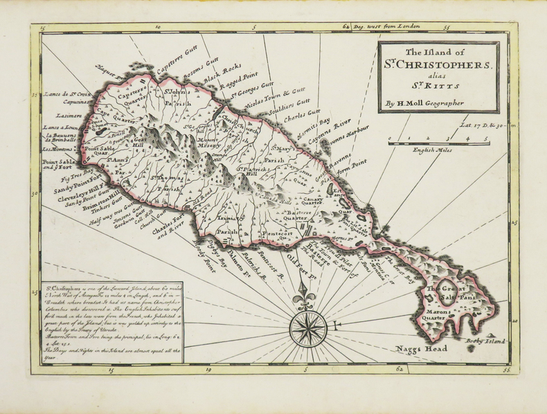
MOLL (Herman).
[SAINT KITTS] The Island of St. Christophers alias St. Kitts.
Londres, Thomas and John Bowles, [circa 1736]. 199 x 274 mm.
Bookseller reference : LBW-3534
|
|
|
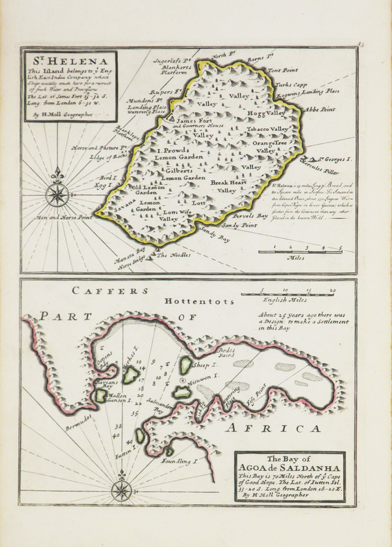
MOLL (Herman).
[SAINTE-HELENE] St. Helena - The bay of Agoa de Saldanha.
[Londres], Thomas and John Bowles, [circa 1736]. 275 x 203 mm.
Bookseller reference : LBW-3543
|
|
|
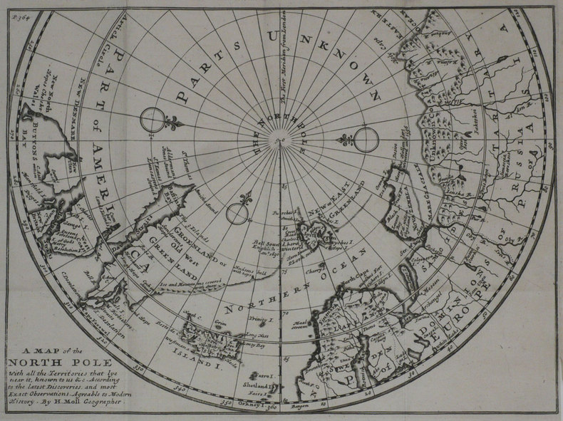
MOLL (Herman);
A Map of the North pole with all the territories that lye near it.
Londres 1739 201 x 271 mm.
Bookseller reference : LBW-1194
|
|
|
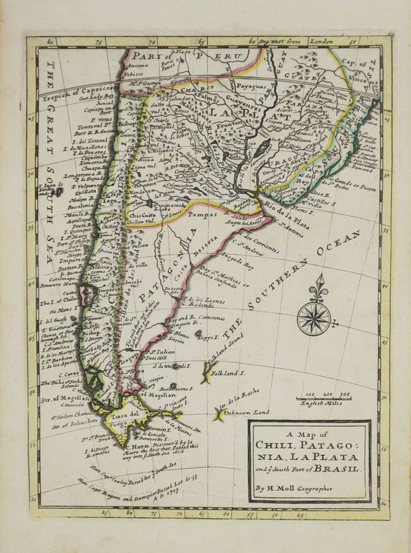
MOLL (Herman).
A Map of Chili, Patagonia, La Plata and ye south part of Brasil.
[Londres], Thomas and John Bowles, [circa 1736]. 276 x 206 mm.
Bookseller reference : LBW-3519
|
|
|
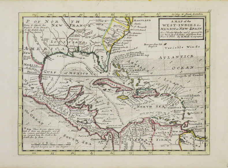
MOLL (Herman).
A Map of the West-Indies &c Mexico or New Spain.
Londres, Thomas and John Bowles, [circa 1736]. 198 x 264 mm.
Bookseller reference : LBW-3544
|
|
|
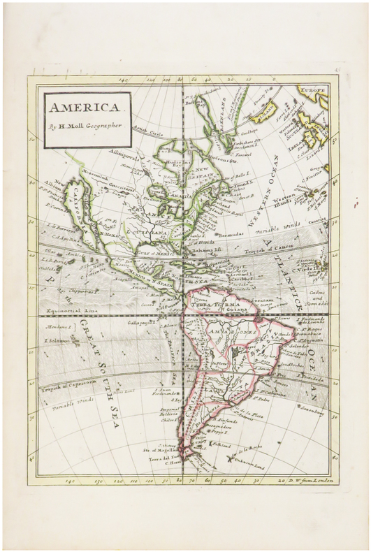
MOLL (Herman).
America.
[Londres, 1739]. 263 x 198 mm.
Bookseller reference : LBW-482
|
|
|
MOLS-MARCHAL L.
NOUVELLE CARTE DU ROYAUME DES PAYS BAS
1875 carte noire entoilée, pliée in-octavo, dépliée - largeur 83,50 centimètres sur 69 centimètres de hauteur, délimiations en couleurs, 1875 Bruxelles L. Mols-Marchal,
Bookseller reference : 3646
|
|
|
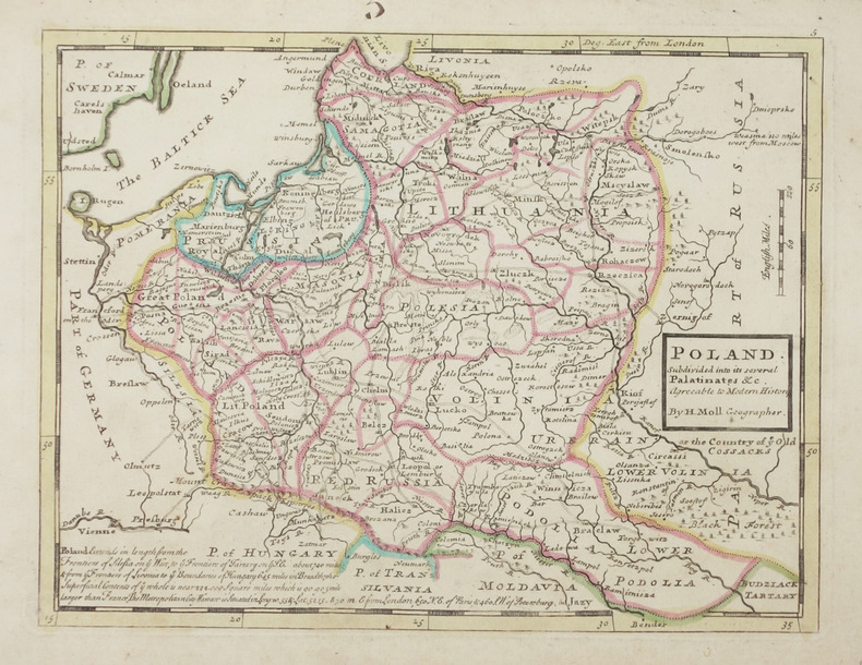
MOLL (Herman).
Poland subdivided into its several palatinates &c.
Londres, Thomas and John Bowles, [circa 1736]. 199 x 260 mm.
Bookseller reference : LBW-2903
|
|
|
MOLINI Giuseppe (Attivo a Firenze inizio '800)
Hemisphere Maritime /Hemisphere Terrestre
Carta geografica del mondo con proiezione gnomonica, pubblicata a Firenze nel 1806/7. Incisione in rame, coloritura coeva, in perfette condizioni. Rara.Mappa tratta dall'Atlas historique, chronologique, geographique et genealogique.Questa rara mappa del mondo mostra due emisferi e i percorsi di viaggio della Famiglia Polo (1230-1295), degli esploratori Magellano e Pigafetta (1519-1522), James Cook (1776-1780) e George Vancouver (1790-1795).Sono rappresentati il "Mare dell'Ovest" e un passaggio nord-ovest molto chiaramente delineato.La mappa fu pubblicata da Giuseppe Molini, attivo a Firenze all'inizio del XIX secolo. Map taken from Atlas historique, chronologique, geographique et genealogique.This very rare world map shows two hemispheres and displays the travel routes of the Polo Family (1230-1295), the explorers Magellan and Pigafetta (1519-1522), James Cook (1776-1780) and George Vancouver (1790-1795) in colored lines. The mythical "Sea of the West" is shows in detail in the northwest of the continent. It also shows a very clearly delineated Northwest Passage.The map was published by Giuseppe Molini, who was active in Florence in early 19th centery. He teamed with Landi to publish several maps and atlases, most of them copied from works of other French cartographers including Brue and Le Sage.

|
|
|
Moll Herman Pugsley William H. William Howard donor WH. Pugsley Collection of Early Canadian Maps W. H.
New Found Land St. Laurence Bay the fishing banks Acadia and part of New Scotland 1763 Leather Bound
2019. Leather Bound. New. Leather Binding on Spine and Corners with Golden Leaf Printing on round Spine extra customization on request like complete leather Golden Screen printing in Front Color Leather Colored book etc. Reprinted in 2019 with the help of original edition published long back 1763. This book is printed in black & white sewing binding for longer life Printed on high quality Paper re-sized as per Current standards professionally processed without changing its contents. As these are old books we processed each page manually and make them readable but in some cases some pages which are blur or missing or black spots. If it is multi volume set then it is only single volume if you wish to order a specific or all the volumes you may contact us. We expect that you will understand our compulsion in these books. We found this book important for the readers who want to know more about our old treasure so we brought it back to the shelves. Hope you will like it and give your comments and suggestions. Lang: - English. EXTRA 10 DAYS APART FROM THE NORMAL SHIPPING PERIOD WILL BE REQUIRED FOR LEATHER BOUND BOOKS. COMPLETE LEATHER WILL COST YOU EXTRA US$ 25 APART FROM THE LEATHER BOUND BOOKS. hardcover
Bookseller reference : LB1111007010987
|
|
|
Moll Herman Pugsley William H. William Howard donor WH. Pugsley Collection of Early Canadian Maps W. H.
New Found Land St. Laurence Bay the fishing banks Acadia and part of New Scotland 1763 FULL LEATHER BOUND
2019. SUPER DELUXE EDITION. New. Antique look with Golden Leaf Printing and embossing with round Spine completely handmade bindingextra customization on request like Color Leather Colored book special gold leaf printing etc. Reprinted in 2019 with the help of original edition published long back 1763. This book is printed in black & white sewing binding for longer life Printed on high quality Paper re-sized as per Current standards professionally processed without changing its contents. As these are old books we processed each page manually and make them readable but in some cases some pages which are blur or missing or black spots. If it is multi volume set then it is only single volume if you wish to order a specific or all the volumes you may contact us. We expect that you will understand our compulsion in these books. We found this book important for the readers who want to know more about our old treasure in old look so we brought it back to the shelves. Hope you will like it and give your comments and suggestions. Lang: - English. EXTRA 10 DAYS APART FROM THE NORMAL SHIPPING PERIOD WILL BE REQUIRED. Normal Hardbound Edition is also available on request. unknown
Bookseller reference : SD1111007010987
|
|
|
Moll Herman Pugsley William H. William Howard donor WH. Pugsley Collection of Early Canadian Maps W. H.
New Found Land St. Laurence Bay the fishing banks Acadia and part of New Scotland 1763
2019. Paperback. New. Lang: - English. Reprinted in 2019 with the help of original edition published long back 1763. This book is Printed in black & white sewing binding for longer life with Matt laminated multi-Colour Soft Cover HARDCOVER EDITION IS ALSO AVAILABLE Printed on high quality Paper re-sized as per Current standards professionally processed without changing its contents. As these are old books we processed each page manually and make them readable but in some cases some pages which are blur or missing or black spots. If it is multi volume set then it is only single volume if you wish to order a specific or all the volumes you may contact us. We expect that you will understand our compulsion in these books. We found this book important for the readers who want to know more about our old treasure so we brought it back to the shelves. Any type of Customisation is possible with extra charges. Hope you will like it and give your comments and suggestions. paperback
Bookseller reference : PB1111007010987
|
|
 Receive by email
 Download as PDF document
 RSS feed


