|
Ocean Explorer Maps
Antarctic Explorer Map; Ocean Explorer Maps
2009-09-07. New. Ships with Tracking Number! INTERNATIONAL WORLDWIDE Shipping available. May be re-issue. Buy with confidence excellent customer service! unknown
Bookseller reference : 0954371763n ISBN : 0954371763 9780954371760

|
|
|
Ocean Explorer Maps
Antarctic Explorer Map; Ocean Explorer Maps
Ocean Explorer Maps 2009-01-01. Map. Used:Good. Ocean Explorer Maps unknown
Bookseller reference : DADAX0954371763 ISBN : 0954371763 9780954371760
|
|
|
Ocean Explorer Maps
Caribbean Islands explorer map Ocean Explorer Maps
2003-01-04. New. Ships with Tracking Number! INTERNATIONAL WORLDWIDE Shipping available. May be re-issue. Buy with confidence excellent customer service! unknown
Bookseller reference : 0954371704n ISBN : 0954371704 9780954371708

|
|
|
Ocean Explorer maps
Falkland Islands Explorer Map
Ocean Explorer Maps 2007-02-22. Map. Used:Good. Ocean Explorer Maps unknown
Bookseller reference : DADAX0954371747 ISBN : 0954371747 9780954371746
|
|
|
Ocean Explorer maps
Falkland Islands Explorer Map
2007-05-08. New. Ships with Tracking Number! INTERNATIONAL WORLDWIDE Shipping available. May be re-issue. Buy with confidence excellent customer service! unknown
Bookseller reference : 0954371747n ISBN : 0954371747 9780954371746

|
|
|
Ocean Explorer Maps
Galapagos Islands : Explorer Ocean Explorer Maps
2005-08-01. New. Ships with Tracking Number! INTERNATIONAL WORLDWIDE Shipping available. May be re-issue. Buy with confidence excellent customer service! unknown
Bookseller reference : 0954371771n ISBN : 0954371771 9780954371777

|
|
|
Ocean Explorer Maps
Greenland Explorer
Ocean Explorer Maps Apr-2008. U. New. Ocean Explorer Maps unknown
Bookseller reference : 6133479440 ISBN : 0954371755 9780954371753
|
|
|
Ocean Explorer Maps
Mediterranean Explorer Ocean Explorer Maps
2006-09-01. New. Ships with Tracking Number! INTERNATIONAL WORLDWIDE Shipping available. May be re-issue. Buy with confidence excellent customer service! unknown
Bookseller reference : 0954371739n ISBN : 0954371739 9780954371739

|
|
|
Ocean Explorer Maps
Mediterranean Explorer Ocean Explorer Maps
Ocean Explorer Maps 2006-01-01. Map. Used:Good. Ocean Explorer Maps unknown
Bookseller reference : DADAX0954371739 ISBN : 0954371739 9780954371739
|
|
|
OCEAN PACIFIQUE
Oc?an pacifique et ses principaux archipels. Carte couleur.
1 feuille 80 x 67 cm.
|
|
|
Oddvar Bjorklund Haakon Holmboe and Anders Rehr. Maps By Berit Lie
Chambers Atlas of World History. 108 Maps. Illustrating the Movement and Progress of History From 3000 BC
Edinburgh: Chambers. Very Good. 1977. Reprint. Soft Cover. 8vo - over 7�" - 9�" Tall Octavo 0550180079 Paperback Paperback. Chambers Atlas of World History. This handbook provides the general reader with a geographical perspective of major world events from ancient times to the present day. The overall effect of the course of wars migrations cultural influences - in short the growth or decline of nations - is graphically ilustrated giving history a clear and physical dimension. We carry a wide selection of titles in The Arts Theology History Politics Social and Physical Sciences. Academic and Scholarly books and Modern First Editions and all types of Educational Reference Literature. . Chambers paperback
Bookseller reference : 103915 ISBN : 0550180079 9780550180070
|
|
|
Odile LOZACHMEUR
QUIZZ DES FRANCAIS(ES) CELEBRES: De Cro-Magnon à nos jours
OUEST-FRANCE 2014 200 pages 10 8x2 2x17 6cm. 2014. Broché. 200 pages.
Bookseller reference : 500034956

|
|
|
Odyssey Books and Maps
Laos : The Mekong River from Source to Sea
2014-03-09. New. Ships with Tracking Number! INTERNATIONAL WORLDWIDE Shipping available. May be re-issue. Buy with confidence excellent customer service! unknown
Bookseller reference : 9622178537n ISBN : 9622178537 9789622178533

|
|
|
OEXMELIN (Alexandre-Olivier)
Histoire des flibustiers-aventuriers américains au XVIIème siècle
Paris, Librairie Ch. Delagrave, 1888 , in-12 (175x110) , seconde édition ,317 pp, relié pleine percale décorée éditeur , tête dorée , papier jauni , déchirure au dos.
Bookseller reference : PHO-828

|
|
|
Office United States. Hydrographic; maps. Illustrated by 3 fold color
Pacific Islands Pilot Volume I
GPO. Very Good with no dust jacket. 1928. Third. Hardcover. Includes fold-out map. Boards lightly rubbed. Binding tight inner pages unmarked. ; Western Groups; 788 pages . GPO hardcover
Bookseller reference : 39387
|
|
|
ohne Autor
(Ekuador) Guia general del Ecuador.
Guayaquil, Publicistas, 1959. Mehrfach gefaltete Farbkarte.
Bookseller reference : 4624
|
|
|
ohne Autor
(Mexiko) Las Carreteras de Mexico. Road Map of/Carta de Caminos Mexico.
ohne Ort, Rand McNally (ohne Jahr). Mehrfach gefaltete Straßenkarte.
Bookseller reference : 4647
|
|
|
Olami, Ya'aqov ; Sender, Shlomo ; Oren, Eldad
Archaeological Survey of Israel: Map of Yagur (27)
Contains a map. 24x17 cm. 102+72 pages. Softcover. In good condition.
|
|
|
OLAVSEN (Eggert), POVELSEN (Bjarne)
Voyage en Islande, fait par ordre de S. M. Danoise, contenant des observations sur les moeurs et les usages des habitans ; une description des lacs, rivières, glaciers, sources chaudes et volcans [...]. Traduit par Gauthier de Lapeyronie.
Paris, Levrault, 1802. 5 tomes in-8 et 1 atlas in-4, texte relié plein basane époque, dos lisse orné de caissons et frises dorés, pièces de titre et de tomaison rouges, frise dorée en encadrement des plats, coins usés, trace de réparation au plat tome 4, petits frottements et légères épidermures et l’Atlas en reliure d’attente bleu, étiquette avec titre au plat, coins usés, coiffes absentes et début de fente au mors, quelques rousseurs à l’atlas.
Bookseller reference : PHO-1700

|
|
|
Old House Books & Maps
London & North Eastern Railway Map 1924
Old House Books 06/10/2012. Map. Used; Good. WE SHIP WITHIN 24 HRS FROM LONDON UK 98% OF OUR ORDERS ARE RECEIVED WITHIN 7-10 DAYS. We believe you will be completely satisfied with our quick and reliable service. All orders are dispatched as swiftly as possible! Buy with confidence! Old House Books unknown
Bookseller reference : 3210661 ISBN : 1908402288 9781908402288

|
|
|
Old House Books & Maps
The 10.30 Limited: A Railway Book for Boys of All Ages Old House Railway History Gwr
Old House Books 04/10/2012. Hardcover. Used; Good. WE SHIP WITHIN 24 HRS FROM LONDON UK 98% OF OUR ORDERS ARE RECEIVED WITHIN 7-10 DAYS. We believe you will be completely satisfied with our quick and reliable service. All orders are dispatched as swiftly as possible! Buy with confidence! Old House Books hardcover
Bookseller reference : 2265751 ISBN : 1908402172 9781908402172

|
|
|
Old House Books & Maps
The 10.30 Limited: A Railway Book for Boys of All Ages Old House
Old House Books 2012. This is an ex-library book and may have the usual library/used-book markings inside.This book has hardback covers. In fair condition suitable as a study copy. Please note the Image in this listing is a stock photo and may not match the covers of the actual item300grams ISBN:9781908402172 Old House Books hardcover
Bookseller reference : 4464977 ISBN : 1908402172 9781908402172
|
|
|
OLD MAPS
Alte Karten aus Meisterhand. Sammelmappe mit 24 ausgew�hlten Reproduktionen. Begleittext in deutsch englisch und franz�sisch von W. Horn. Zusammenstellung und Redaktion: H. T�ubert.
Gotha : Hermann Haack Geographisch-Kartographische Anstalt 1987. HARDCOVER . Hlf cloth portfolio with col old map on front. VERY GOOD. Gotha : Hermann Haack Geographisch-Kartographische Anstalt hardcover
Bookseller reference : 4154
|
|
|
OLD MAPS & GLOBES
Oude kaarten & globes uit het bezit van de Universiteitsbibliotheek het Universiteitsmuseum en het Geografisch Instituut der Rijksuniversiteit te Utrecht
1965. SOFTCOVER . Orig. pictorial wrappers edges slightly discol else AS NEW. Interesting exposition catalogue. paperback
Bookseller reference : 3863
|
|
|
Old Ordnance Survey maps: London
Clerkenwell Kings Cross & The Angel 1894
Alan Godfrey Maps. Minor creasing to a clean folding map. Clerkenwell Kings Cross & The Angel 1894. London Sheet 50. Old Ordnance Survey Maps - The Godfrey Edition . Very Good. Soft cover. 1994. Alan Godfrey Maps paperback
Bookseller reference : 047996 ISBN : 0850547016 9780850547016
|
|
|
OLEARIUS (Adam) , MANDELSO (J.A. de) , WICQUEFORT (A. de , traducteur)
Relation du voyage d'Adam Olearius en Moscovie, Tartarie et Perse , augmentée en cette nouvelle édition... d'une seconde partie contenant le voyage de Jean Albert de Mandelslo aux Indes Orientales, traduit de l'allemand par A. de Wicquefort
Paris, Dezallier, 1679, 2 volumes in-4 ,28ff.-686pp., 22ff-648pp , relié plein cuir époque, dos à nerfs orné avec pièce de titre et tomaison, tranches mouchetées rouge, réparations aux dos, pièces de titre et tomaison récentes au tome, illustré de 6 cartes dépliantes (7), ex-libris manuscrit en page de garde et au titre, traces de réparation aux cartes.
Bookseller reference : PHO-1772

|
|
|
OLEARIUS (Adam), MANDELSO (J.A. de), WICQUEFORT (A. de, traducteur)
Relation du voyage d'Adam Olearius en Moscovie, Tartarie et Perse, augmentée en cette nouvelle édition... d'une seconde partie contenant le voyage de Jean Albert de Mandelslo aux Indes Orientales, traduit de l'allemand par A. de Wicquefort,... - Suitte du voyage en Moscovie. Tartarie et Perse, avec celuy de J. A. de Mandelslo aux Indes orientales, contenant une description... de l'Indosthan, de l'empire du Mogul, des isles de l'Orient, du Japon, de la Chine….
Paris, Jean Du Puis, 1659 et 1666 ,2 volumes in-4 ,27ff.-686pp., 22ff-648pp , relié tome 1 ; plein veau moucheté époque, dos à nerfs ornés avec titre et tomaison, tranches mouchetées rouges, coiffe supérieure arasée, coins usés, début de fente, petites rousseurs, Tome 2 ; plein veau, dos à nerfs ornés avec titre et tomaison, filets aux plats, tranches rouges, frottements et épidermures, une charnière fendue, coins usés, coiffes absentes, rousseurs, défauts à la carte du cour de la Volga, 2 cartes détachées et déchirures sans manque sur 2 cartes, mouillure angulaire sur quelques feuillets.. Illustré de 6 cartes dépliantes dont La grande carte du cours de la Volga et la Nouvelle carte de la Perse, la première carte réaliste de l'Iran qui corrige notamment l'emplacement et la forme de la mer Caspienne.
Bookseller reference : PHO-1912

|
|
|
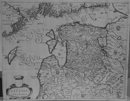
OLEARIUS (Adam).
[LETTONIE] La Livonie ou Liflande.
[1659]. 279 x 361 mm.
Bookseller reference : LBW02521
|
|
|
Olearius, Adam
La Livonie ou Liflande. Original-Kupferstichkarte, unkoloriert.
[Paris, A. Dezailler, 1679]. 28,5 x 36,5. Unter Passepartout.
Bookseller reference : 78821

|
|
|
Olearius, Adam (1599-1671)
Vera delineatio provinciae fertilissimae Kilan olim Hyrcaniae ad mare Caspium sitae. [Kaspisches Meer]. Per Ad. Olearium.
O. O. (Paris), (Jean Dupuis), ( 1659). Kupferstich. Darstellung ca. 28 x 33 cm, Blattmaß 31 x 42 cm. Feinkartonpassepartout.
Bookseller reference : 78800

|
|
|
OLIVIER-JUSSEAUME.
[INDRE-et-LOIRE] Réunion de deux cartes manuscrites dessinées en 1816 par Olivier-Jusseaume, pour son oncle, Mr Fortin.
1816.
Bookseller reference : LBW-7448
|
|
|
OLIVIERI Bernardino (Roma, 1770 - ?)
Circoli per formare La Sfera Armillare
Foglio contenente delle sezioni di globo - in dodici segmenti - e altri elementi atti a costruire una sfera armillare. Il globo terrestre centrale è in 12 segmenti e avrebbe un diametro di circa 5,5 cm se costruito. La sfera armillare complessiva avrebbe un diametro di 28 cm. I vari anelli della sfera armillare comprendono l'equatore, il Tropico del Cancro, il Tropico del Capricorno, le zone e i cerchi polari e antartici. Tavola edita dalla Calcografia Camerale, Roma 1795 e tratta dal Nuovo Atlante Geografico Universale delineato sulle ultime osservazioni, edito a Roma dal 1792 fino al 1801, opera che la Calcografia Camerale commissionò al Cassini al fine di sostituire l’ormai obsoleto Mercurio Geografico della tipografia De Rossi. Bernardino Olivieri fu cartografo incisore presso la Calcografia Camerale di Roma sitauta nel Collegio di Propaganda Fide Incisione in rame, finemente colorata a mano, in ottime condizioni. Rara. This matching set of sheets contain the pieces to construct an armillary sphere. The central terrestrial globe is in 12 segments and would have a diameter of approximately 5.5 cm if constructed. The overall armillary sphere would have a diameter of 28 cm. The various rings of the armillary sphere include the equator, the Tropic of Cancer, the Tropic of Capricorn, the zones, and the Polar and Antarctic circles. Uncommon maps, published in the Nuovo Atlante Geografico Universale, that was commissioned to Cassini by the Calcografia Camerale, in order to replace the obsolete De Rossi's Mercurio Geografico. Bernardino Olivieri was a cartographer and engraver at the Calcografia Camerale di Roma located in the Collegio di Propaganda Fide. Copper engraving, finely hand colored, in very good condition. Rare.

|
|
|
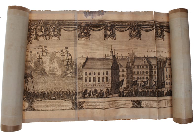
ONE OF THE LARGEST ENGRAVED FUNERAL PROCESSIONS - ERIK DAHLBERG.
Exequiae Serenissimi ac Potentiss: Principis ac Dni. Domini Caroli Gustavi Suecorum Gothorum et Wandalorum Regis d. 3. Nouemb. 1660 Holmiæ Celebratæ. Accuraté delineauit E.I. Dahlbergh. (The funeral procession of King Carl X Gustav of Sweden).
(Nürnberg, 1696). The large engraving of the procession through Stockholm being composed of 13 engraved plates joined together, measuring 30x450 cm. (Plates numb. 1-13). Some mostly marginal dampstains, some marginal tears, some brownspots mainly marginal. Upper margin of plate 3 partly gone. Margins strenghtened at verso with brown paper. Some variation to paperquality, but in general in good strong impressions.
Bookseller reference : 32611
|
|
|
ONE OF THE LARGEST ENGRAVED FUNERAL PROCESSIONS - ERIK DAHLBERG.
Exequiae Serenissimi ac Potentiss: Principis ac Dni. Domini Caroli Gustavi Suecorum Gothorum et Wandalorum Regis d. 3. Nouemb. 1660 Holmiæ Celebratæ. Accuraté delineauit E.I. Dahlbergh. (The funeral procession of King Carl X Gustav of Sweden).
(Nürnberg, 1696). The large engraving of the procession through Stockholm being composed of 13 engraved plates joined together, measuring 30x450 cm. (Plates numb. 1-13). Some mostly marginal dampstains, some marginal tears, some brownspots mainly marginal. Upper margin of plate 3 partly gone. Margins strenghtened at verso with brown paper. Some variation to paperquality, but in general in good strong impressions.
|
|
|
Orchard, Imbert
Floodland and Forest - Memories of the Chilliwack Valley - Sound Heritage Series Number 37
92 pages. Based upon 15 tape recorded interviews with people of the Chilliwack area conducted in the early 1960s. Replete with historical photos and maps. Book
|
|
|
ORDANCE SURVEY
Ordnance Survey [Tourist] Map of Dorking & Leith Hill. One Inch to One Mile. ['Official Royal Arms' cover].
Folding coloured map on paper measuring 24 x 33 ins (approx. 61.0 x 84.0 cms) folding in 32 panels to 7.5 x 4.25 ins (approx. 19.0 x 11.0 cms), neat contemporary signature on front cover, one or two neat repairs at folds; original pictorial card wrappers, yapped edges, wrappers lightly age-soiled else a very good, bright, clean copy. The One Inch Tourist Map series was first published in 1924 with 'Official Royal Arms' artwork. The present copy is the 1929 revision; the cover is single red lineation on buff with black arms, red sheet name and location map. Browne, 8.1.a.1.

|
|
|
ORDENER Paul.-
Les Sports. Jeu des Familles.-
Paris. Nathan. s.d. Jeu complet de 48 cartes illustrées en couleurs par Paul ORDENER, dans un coffret (160 x 118mm) de carton rouge orné d'une grande vignette couleurs. Tout petits défauts mais bon exemplaire bien complet de la règle du jeu (enfants de 7 à 12 ans).
Bookseller reference : ORD-7929
|
|
|
Ordnance Maps of Great Britain
ORDNANCE SURVEY ONE-INCH MAP OF GLASGOW
Ordinance Survey Office Surrey. 1945. A very good copy. Original price three shillings. Canvas like backing on the large fold-out map that is 32" X 23". See my other maps for sale. Sheet 72. Minister of Agriculture and Fisheries
Bookseller reference : 2011

|
|
|
Ordnance Survey
ORDNANCE SURVEY England & Wales Sheet 118. Large Sheet Series Scale 1 Inch to a Mile. Canterbury Margate Ramsgate Etc.
Southampton: Ordnance Survey Office 1913. "Published at the Ordnance Survey Office Southampton 1909 Railways revised to 1913". Original cloth backed coloured map folding into printed cloth-backed card covers. Map is very good with a little wear to corners of folds bottom edge a little worn covers somewhat marked previous owner's name. A very good copy. Paper Covers. Very Good. Map. Ordnance Survey Office hardcover
Bookseller reference : 011525

|
|
|
Ordnance Survey Maps:
Victorian Ordnance Survey Maps: London
Great Britain: David & Charles 2004. Victorian Ordnance Survey Maps: London Originally engraved in the early 1820s these four maps cover the Victorian city of London and the surrounding area including Windsor Watford Brentwood Southend Maidstone Guildford and Bracknell. in very good slipcase We carry a wide selection of titles in The Arts Theology History Politics Social and Physical Sciences. Academic and Scholarly books and Modern First Editions and all types of Educational Reference Literature. . First Thus. Very Good. Maps . David & Charles unknown
Bookseller reference : 100177 ISBN : 0715318640 9780715318645

|
|
|
Ordnance Survey
Buxton & Matlock: Sheet 111
The folded map is in very good condtion, the covers are dusty, (One Inch Map of Great Britain Seventh Series). eng
|
|
|
Ordnance Survey
Hereford: Sheet 142
covers repaired. eng
|
|
|
Ordnance Survey
Killarney & Dingle Bay : Survey of Ireland Sheet 20 : Quarter Inch
No marks or inscriptions. A clean bright slightly sunned unmarked folded map opens up to 21 x 30 inches. Tears (2 and 3 inches) along two folds and small opening up at two corners 1pp. Ordnance Survey of Ireland quarter inch to 1 mile map of Killarney & Dingle Bay. Scarce.
|
|
|
Ordnance Survey
Landranger Maps: Blairgowrie Sheet 53
Light creasing to the covers, map itself very good used condition, (Landranger Series of Great Britain). eng
|
|
|
ORDNANCE SURVEY
Map of Southern Britain in the Iron Age. Scale 1: 625,000. About Ten Miles to One Inch. [Second Edition.] NEAR FINE COPY
8vo., Second Edition, with large folding coloured map and classified gazetteer; pictorial wrappers, yapped edges, a near fine copy. Updated version of the first edition of 1962.
|
|
|
ORDNANCE SURVEY
Ordnance Survey Contoured Road Map of Barnstaple and Exmoor. Popular Edition. One Inch, Sheet 118. [Ellis Martin cover].
Folding coloured map on cloth measuring 21.x 28.5 ins (approx. 53.0 x 72.0 cms) folding in 24 panels to 7.0 x 3.5 ins (approx. 18.0 x 9.0 cms); original pictorial card wrappers a very good bright clean copy. The famous Popular Edition One Inch series was first published in 1919 with striking 'cyclist' artwork by Ellis Martin. The present copy is the 1932 reissue; the covers are black with red sheet name and location map. Browne, 11.1.a

|
|
|
ORDNANCE SURVEY
Ordnance Survey Contoured Road Map of Bicester. Popular Edition. One Inch, Sheet 94. [Ellis Martin cover]. BRIGHT, CLEAN COPY
Folding coloured map on cloth measuring 22 x 30 ins (approx. 56.0 x 76.0 cms) folding in 21 panels to 7.5 x 4.5 ins (approx. 19.0 x 11.5 cms); original pictorial card wrappers, neat contemporary signature on upper wrapper, wrappers lightly age-soiled else a very good, bright, clean copy. The famous Popular Edition One Inch series was first published in 1919 with striking 'hiker' artwork by Ellis Martin. The present copy is the 1930 revision (roads revised to June 1926); the covers are the dark red and black variant with location map. Browne, 11.2.a

|
|
|
ORDNANCE SURVEY
Ordnance Survey Contoured Road Map of Bridgwater and District. Popular Edition. One Inch. Sheet 120. [Ellis Martin cover].
Folding coloured map on cloth measuring 21 x 30 ins (approx. 53.0 x 76.0 cms) folding in 24 panels to 7.0 x 3.75 ins (approx. 18.0 x 9.5 cms); original pictorial card wrappers, wrappers lightly age-soiled else a very good, bright, clean copy. The famous Popular Edition One Inch series was first published in 1919 with striking 'hiker' artwork by Ellis Martin. The present copy is the 1926 revision; the covers are the dark red and black variant with location map. Browne, 11.2.a

|
|
|
Ordnance Survey
Ordnance Survey Contoured Road Map of Carmarthen : Sheet 89 : One-inch Popular Edition (cloth)
Previous owner's initials to front cover. No creasing to covers. A very clean unmarked map with creasing to some corners and a little rubbing to some of the map's folded corners and edges. Cloth backed edition. 1pp.

|
|
|
ORDNANCE SURVEY
Ordnance Survey Contoured Road Map of Carmarthen. Popular Edition. One Inch. Sheet 89. [Ellis Martin cover].
Folding coloured map on cloth measuring 22.0 x 28.5 ins (approx. 56.0 x 72.0 cms) folding in 21 panels to 7.5 x 4.25 ins (approx. 19.0 x 11.0 cms), small neat contemporary signature on front wrapper else a very good, bright, clean copy. The famous Popular Edition One Inch series was first published in 1919 with striking 'hiker' artwork by Ellis Martin. The present copy is the 1923; the covers are the dark red and black variant with location map. Browne, 11.2.a

|
|
 Receive by email
 Download as PDF document
 RSS feed


