|
Outdoor Books & Maps
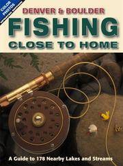
Denver & Boulder Fishing Close to Home
Outdoor Books & Maps 2007-05-31. 4th. Paperback. Used:Good. Outdoor Books & Maps paperback
Referentie van de boekhandelaar : DADAX0930657519 ISBN : 0930657519 9780930657512
|
|
|
Outdoor Books & Maps
Denver & Boulder Fishing Close to Home
Outdoor Books & Maps 2007-05-31. Paperback. Good. Outdoor Books & Maps paperback
Referentie van de boekhandelaar : SONG0930657519 ISBN : 0930657519 9780930657512
|
|
|
Outdoor Books & Maps Firm
Fishing Close to Home
Outdoor Books and Maps 1996-03. Paperback. Good. Outdoor Books and Maps paperback
Referentie van de boekhandelaar : SONG0930657055 ISBN : 0930657055 9780930657055
|
|
|
Outdoor Books & Maps
Pike National Forest: Trail Information for Any Age Group and Skill Level Colorado Recreation Guide National Forest Series
Outdoor Books and Maps 1998-01-01. Paperback. Good. Outdoor Books and Maps paperback
Referentie van de boekhandelaar : SONG093065711X ISBN : 093065711X 9780930657116

|
|
|
Outdoor Books & Maps
Rio Grande National Forest Recreation Guide National forest series
Outdoor Books & Maps 1996-08-01. Paperback. Used:Good. Outdoor Books & Maps paperback
Referentie van de boekhandelaar : DADAX0930657152 ISBN : 0930657152 9780930657154

|
|
|
Outdoor Books & Maps
Routt National Forest Recreation Guide National Forest Series
Outdoor Books & Maps 1996-05-01. Paperback. Used:Good. Outdoor Books & Maps paperback
Referentie van de boekhandelaar : DADAX0930657128 ISBN : 0930657128 9780930657123

|
|
|
Outdoor Books & Maps
Routt National Forest Recreation Guide National Forest Series
Outdoor Books & Maps 1996-05-01. Paperback. Used:Good. Outdoor Books & Maps paperback
Referentie van de boekhandelaar : SONG0930657128 ISBN : 0930657128 9780930657123
|
|
|
Outdoor Books & Maps
San Isabel National Forest Recreation Guide National Forest Series
1995-08-07. New. Ships with Tracking Number! INTERNATIONAL WORLDWIDE Shipping available. May be re-issue. Buy with confidence excellent customer service! unknown
Referentie van de boekhandelaar : 0930657144n ISBN : 0930657144 9780930657147

|
|
|
Outdoor Books & Maps
San Isabel National Forest Recreation Guide National Forest Series
Outdoor Books & Maps 1995-05-01. Revised 2000. Paperback. Used:Good. Outdoor Books & Maps paperback
Referentie van de boekhandelaar : DADAX0930657144 ISBN : 0930657144 9780930657147

|
|
|
Outdoor Books & Maps
San Isabel National Forest Recreation Guide National Forest Series
Outdoor Books & Maps 1995-05-01. Paperback. Used:Good. Outdoor Books & Maps paperback
Referentie van de boekhandelaar : SONG0930657144 ISBN : 0930657144 9780930657147
|
|
|
Outdoor Books & Maps
San Juan National Forest Colorado All-Activities Guidebook
2012-07-02. Good. Ships with Tracking Number! INTERNATIONAL WORLDWIDE Shipping available. May not contain Access Codes or Supplements. May be re-issue. May be ex-library. Shipping & Handling by region. Buy with confidence excellent customer service! unknown
Referentie van de boekhandelaar : 0930657594 ISBN : 0930657594 9780930657598

|
|
|
Outdoor Books and Maps Inc. Staff
The Complete Colorado Campground Guide
Adler Publishing Company 1999. Paperback. Acceptable. Disclaimer:A readable copy. All pages are intact and the cover is intact. Pages can include considerable notes-in pen or highlighter-but the notes cannot obscure the text. At ThriftBooks our motto is: Read More Spend Less.Dust jacket quality is not guaranteed. Adler Publishing Company paperback
Referentie van de boekhandelaar : G0930657233I5N00 ISBN : 0930657233 9780930657239

|
|
|
Outdoor Books & Maps
The Complete Colorado Campground Guide & Atlas
Outdoor Books & Maps. Used - Good. Shows some signs of wear and may have some markings on the inside. Outdoor Books & Maps unknown
Referentie van de boekhandelaar : GRP30410597 ISBN : 0930657233 9780930657239

|
|
|
Outdoor Books & Maps
The Complete Colorado Campground Guide & Atlas
Outdoor Books & Maps 2005-07-01. Paperback. Good. Outdoor Books & Maps paperback
Referentie van de boekhandelaar : SONG0930657233 ISBN : 0930657233 9780930657239
|
|
|
Outdoor Books & Maps
White River National Forest Recreation Guide National Forest Series
Outdoor Books & Maps 1996-05-01. Paperback. Used:Good. Outdoor Books & Maps paperback
Referentie van de boekhandelaar : DADAX0930657160 ISBN : 0930657160 9780930657161

|
|
|
Outdoor Books & Maps
White River National Forest Recreation Guide National Forest Series
Outdoor Books & Maps 1996-05-01. Paperback. Good. Outdoor Books & Maps paperback
Referentie van de boekhandelaar : SONG0930657160 ISBN : 0930657160 9780930657161
|
|
|
OUTHIER (Réginald, abbé).
Carte topographique du diocèse de Sens divisé en ses cinq archidiaconés et ses douze doyennés.
Sens, André Jannot, et Paris, Ve Mazieres et J. Bap.te Garnier, 1741. En deux feuilles jointes de 725 x 870 mm.
Referentie van de boekhandelaar : LBW-426

|
|
|
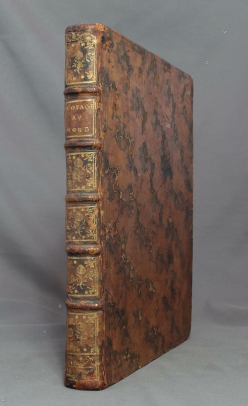
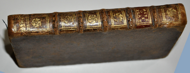
OUTHIER [Abbé Réginald]:
Journal d'un voyage au Nord, en 1736 & 1737.
Paris, Piget; Durand, 1744. In-4 de [8]-238-[2] pages, plein veau marbré brun, dos à nerfs orné de filets et fleurons dorés, pièce de titre brune, tranches rouges.
Referentie van de boekhandelaar : 8781
|
|
|
ouvrage collectif
AIR FRANCE : CARTES ITINERAIRES DUNLOP PARIS-NEW-YORK "LE RUBAN ETOILE"
1970 plaquette in-octavo, couverture illustrée en couleurs, illustrations : cartes itinéraires, sans pagination, 10 feuillets, sans date (les années 1950 environ) à Paris Edicta-Paris,
Referentie van de boekhandelaar : 9199
|
|
|
Oxford University Press Tt Maps & Publications Ltd
An Atlas of India
Oxford University Press USA. Used - Good. Shows some signs of wear and may have some markings on the inside. Oxford University Press, USA unknown
Referentie van de boekhandelaar : GRP78430714 ISBN : 0195625536 9780195625530
|
|
|
Oxford University Press Tt Maps & Publications Ltd
An Atlas of India
Oxford University Press USA. Used - Very Good. Former Library book. Great condition for a used book! Minimal wear. Oxford University Press, USA unknown
Referentie van de boekhandelaar : GRP2836558 ISBN : 0195625536 9780195625530
|
|
|
OZANAM Jacques
Méthode de lever les plans et les cartes de terre et de mer , avec toutes sortes d 'instrumens , & sans instrumens , la description & l ' usage de ces instrumens qui sont le Demi-cercle , la Planchette de diverses façons , la Boussole , l ' Instrument universel , & le Recipiangle . Et la manière de faire la remarque des marées , courants , écueils , etc. & de lever les Plans des villes ennemies .
1716 Paris , Claude Jombert , 1716 , in-8 , (6) ff , 215 , (1) pp , 14 planches depliantes , veau brun , dos à nerfs orné de fleurons dorés Bon etat , photos sur demande
Referentie van de boekhandelaar : 5378
|
|
|
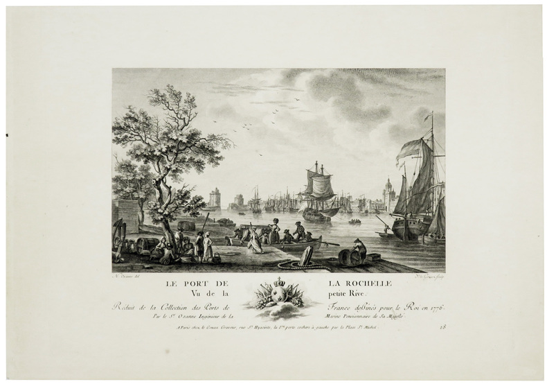
OZANNE (Nicolas).
[LA ROCHELLE] Le port de La Rochelle vu de la petite rive.
[1791]. 180 x 230 mm.
Referentie van de boekhandelaar : LBW-6016
|
|
|
OZANNE (Nicolas).
[OLÉRON] Le port d'Oléron vu en face de l'entrée.
Paris, Le Gouaz, [1791]. 180 x 226 mm.
Referentie van de boekhandelaar : LBW-6269

|
|
|
P Dürr; Stephen H Grant; B Sivan; Emile Tompapa
Images de Guinée, 1890-1925 : réalisation d'après les collections de cartes postales
1991 Conakry : Editions Impr. Mission catholique, 1991.IN 4 broché,sous jacquette et couverture illustrée, 147 pages : illustrations ; 30 cm
Referentie van de boekhandelaar : 21702

|
|
|
P. KAEPPELIN
GEOGRAPHIE
Un ouvrage de 90 pages, format 280 x 220 mm, relié cartonnage couleurs, illustré, s.d. publié au cours de la première moitié du XXe siècle, A. Hatier (Paris)
Referentie van de boekhandelaar : LFA00c29
|
|
|
P.F. Collier & Son Corporation
Collier's World Atlas and Gazetteer
Foilo in maroon stamped and gilted boards; 328 pages : illustrations, maps (some color) ; 37 x 29 cm; indexes Uncommon. // **A large, heavy book. Weighs almost 5 lbs. before packing. Extra shipping charges may apply for international & expedited orders. Please inquire.**
|
|
|
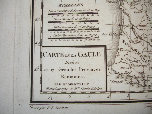
P.F. Tardieu
CARTE DE LA GAULLE XVIIIe 1790
CARTE DE LA GAULLE XVIIIe divisée en 17 Grandes provinces Romaines par M.Mentelle, Historiographe de M. Le Comte d'Artois Gravée par P.F. Tardieu Carte authentique datée vers 1790, sur papier fort, recto uniquement, pliable dimensions : 39 cm x 27 cm Carte en parfait état !
Referentie van de boekhandelaar : CZC-1358
|
|
|
Paassen Pierre Van; End paper Maps Illustrator
Days of Our Years 1903-1938
Garden City Publishing Co 1941-01-01. Hardcover. Good. 19th Printing-1942. A good copy with a tight and square binding. Dark blue cloth boards are good. Text is clean but yellowed. No dust jacket. Careful packaging and fast shipping. We recommend EXPEDITED MAIL for even faster delivery. Garden City Publishing Co hardcover
Referentie van de boekhandelaar : 06972
|
|
|
PACHA (Béatrice) et Ludovic MIRAN
Cartes et plans imprimés de 1564 à 1815. Collections des bibliothèques municipales de la région Centre. Notices de la base BN-Opaline.
Paris, Bibliothèque Nationale de France, 1996. in-4, 330 pages, iconographie couleurs et noir & blanc. Broché, couverture illustrée.
Referentie van de boekhandelaar : 34946
|
|
|
Pacific Northwest Maps Hayes Derek.
Historical Atlas of the Pacific Northwest: Maps of Exploration and Discovery British Columbia Washington Oregon Alaska Yukon.
Seattle:: Sasquatch Books 1999. 1570612153. A Fine copy in a Near Fine bright unclipped dust jacket. This volume provides a visual journey through four centuries of exploration and discovery beginning with the 16th Century Spanish and English explorers. Included are accounts and the cartographic contributions of Sir Francis Drake Vitus Bering James Cook Alexander Mackenzie George Vancouver Lewis & Clark and dozens of other important travelers. Includes 325 map reproductions. Sasquatch Books, unknown
Referentie van de boekhandelaar : 26471 ISBN : 1570612153 9781570612152

|
|
|
Pacific Northwest Maps Hayes Derek.
Historical Atlas of the Pacific Northwest: Maps of Exploration and Discovery British Columbia Washington Oregon Alaska Yukon.
Seattle::: Sasquatch Books 1999. 1570612153. A Fine copy in a Fine bright unclipped dust jacket. This volume provides a visual journey through four centuries of exploration and discovery beginning with the 16th Century Spanish and English explorers. Included are accounts and the cartographic contributions of Sir Francis Drake Vitus Bering James Cook Alexander Mackenzie George Vancouver Lewis & Clark and dozens of other important travelers. Includes 325 map reproductions. Sasquatch Books,, unknown
Referentie van de boekhandelaar : 26159 ISBN : 1570612153 9781570612152

|
|
|
PAGNI (Niccolo) & BARDI (Lorenzo).
Carta del territorio della Repubblica Cisalpina e di parte delli stati limitrofi.
Firenze, Pagni, e Bardi, 1797. En 40 sections montées sur soie verte et pliées, formant une carte de 725 x 1460 mm ; étui de papier avec titre en lettres dorées.
Referentie van de boekhandelaar : LBW-444
|
|
|
PAGÈS, Pierre de.
Voyages autour du monde, et vers les deux poles, par terre et par mer, pendant les années 1767, 1768, 1769, 1770, 1771, 1773, 1774 & 1776.
Paris, Chez Moutard, 1782. 2 Tomes, complet. In-8 - 13 x 20,5 cm. Reliure de l'époque en plein veau marbré, dos lisse orné de caissons dorés aux petits fers, filet doré sur les coupes. 432 pages paginées ; 272 pages paginées. Exemplaire complet de ses 10 hors-texte reliés ensemble à la fin du second volume. Édition originale de cette relation des voyages du capitaine Pagès, illustrée de 7 cartes dépliantes gravées en taille-douce sous la direction de Benard, et de 3 planches dépliantes par le même, dont une montrant le dépècement d'une baleine dessinée par Fossier.
Referentie van de boekhandelaar : 2577

|
|
|
Paher Stanley W. Maps and illustrations by Roy E. Purcell
Las Vegas: As it began - as it grew
Las Vegas: Nevada Publications 1971. 181 pp. b/w illus. throughout. Wrappers handled soiled edgeworn with chipping and one long tape-repaired tear at rear; smudge to fore-edge corners bumped. Interior clean and unmarked. Size: Folio. Paperback. Good/N/A. Nevada Publications Paperback
Referentie van de boekhandelaar : 279380 ISBN : 0913814741 9780913814741
|
|
|
Paher Stanley W./Purcell Roy E. maps/illus
Las Vegas: As It Began as It Grew
Las Vegas: Nevada Paublications 1971. 2nd printing. VG/Good slightly cocked dust jacket chipped/price clipped light musty odor. 181 p. photos maps map on endpapers index 4to; Nevada Paublications hardcover
Referentie van de boekhandelaar : 28552 ISBN : 0913814016 9780913814017
|
|
|
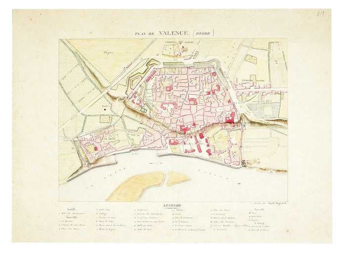
PAIGNARD (Léopold). MANUSCRIT.
Plan de Valence (Drôme).
[circa 1810]. 240 x 335 mm.
Referentie van de boekhandelaar : LBW-736
|
|
|
Painter George D. with illustrations maps drawn by Samuel H. Bryant
Proust; the early years
Boston: Atlantic Monthly Press/Little Brown and Company 1959. Hardcover. xvii 435p. 8p. photos later printing cloth edgeworn dj. Atlantic Monthly Press/Little, Brown and Company hardcover
Referentie van de boekhandelaar : 94939

|
|
|
Painter George D. with illustrations maps drawn by Samuel H. Bryant
Proust; the early years
Boston: Atlantic Monthly Press/Little Brown and Company 1959. Hardcover. xvii 435p. 8p. photos later printing cloth edgeworn dj. Atlantic Monthly Press/Little, Brown and Company hardcover books
Referentie van de boekhandelaar : 94939
|
|
|
PALESTINE.
New Map of Palestine showing the proposed U.N. Boundaries of Israel: Jewish and Arab Towns, Villages and Settlements; Plans of Tel-Aviv, Jerusalem and Haifa; Index of Place names. Scale One Inch to Four and a Half Miles. NEAR FINE COPY OF THE FIRST JEWISH CHRONICLE MAP OF PALESTINE
8vo., folding coloured map on paper measuring 40 x 30 inches (approx. 102 x 76 cms) folding in 30 panels to 8.5 x 5.25 inches (approx. 22 x 13 cms); original blue wrappers printed in black, yapped edges, a virtually unopened, unused copy. EXTREMELY SCARCE IN THIS CONDITION.
|
|
|
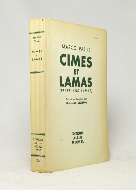
PALLIS Marco; SELLIER-LECLERCQ G. (trad.):
Cîmes et lamas. (Peaks and lamas).
Paris, Editions Albin Michel, 1955. In-8 broché de 334-[2] pages, couverture imprimée.
Referentie van de boekhandelaar : 16668
|
|
|
PALM, Erwin Walter (1910-1988).
Heimkehr ins Exil. Schriften zu Literatur und Kunst. Im Auftrag der Heidelberger Akademie der Wissenschaften. Herausgegeben von Helga von Kügelgen und Arnold Rothe.
Köln & Weimar, Böhlau Verlag, 1992 [Forum Ibero-Americanum]. 4to.; XIV-486 pp. Con 113 ilustraciones fotográficas y reproducciones, en láminas aparte. Cubiertas originales.

|
|
|
Palmer, W. T.
The Handy Guide to the English Lakes
No marks or inscriptions. No creasing to covers or to spine. A very clean very tight copy with foxing to boards, dusty page edges and no bumping to corners. 88pp. Guide to England's Lake District -, covering walking, history, angling, mountaineering, local authorities, places to visit etc. Photographs throughout and cover illustration by W Heaton Cooper. Undated but talks about 1935 in the past. We do not use stock photos, the picture displayed is of the actual book for sale. Every one of our books is in stock in the UK ready for immediate delivery.

|
|
|
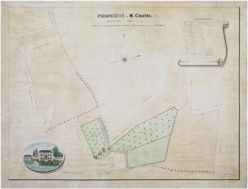
PAMISEUX.
[SEINE-MARITIME] Propriété de M. Chatel Abel, manufacturier à Elbeuf-sur-Seine, située sur la commune de Bosc-le-Hard et par extension sur celle d'Etaimpuis (Seine-Inf.re).
1879. 60 x 80 cm, monté sur une feuille de papier bleu.
Referentie van de boekhandelaar : LBW-7454
|
|
|
Pan American World Airways, Inc.
Pan American World Airways System
Pan American World Airways System : world's most experienced airline ; copyright 1956 by Pan American World Airways, Inc. Cartography by John Philip. Art by Paul John Brown. "All rights reserved by Pan American World Airways, Inc." Litho in U.S.A. 2/64 Revised 2/64.Grande planisfero a proiezione di Mercatore pubblicato dalla Pan Am Airlaines nel 1956.Raffigura tutte le rotte della aereoflotta della Pan Am nel 1956, delineate in rosso sulla mappa.Litografia, in perfetto stato di conservazione. Striking large map of the World, published by Pan American Airlines, as a promotional item.Shows all the routes around the world to which Pan Am flew in 1956, including connecting lines and Pan Am's own lines.Cartography by John Philip. Art by Paul John Brown.Full title:Pan American World Airways System : world's most experienced airline ; copyright 1956 by Pan American World Airways, Inc. Cartography by John Philip. Art by Paul John Brown. "All rights reserved by Pan American World Airways, Inc." Litho in U.S.A. 2/64 Revised 2/64.Full color map 81 1/2x147 1/2. Includes legend. Shows routes of Pan American World Airways System in red lines. Connecting lines, and distances in miles and kilometers are shown. Relief shown pictorially. Includes time zones on lower panel.Litograph, very good condition.

|
|
|
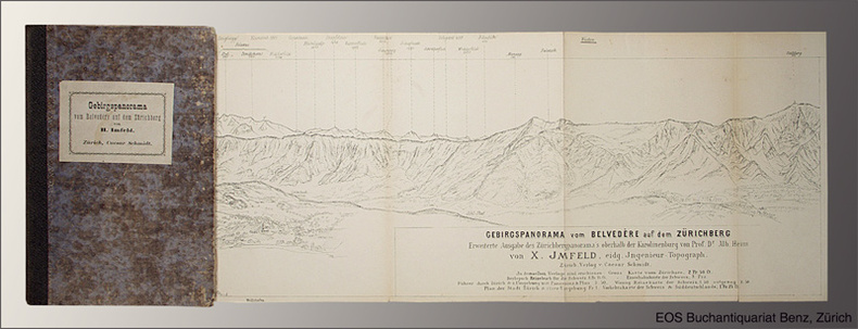
Panorama.- Imfeld, X(aver):
Gebirgspanorama vom Belvedère auf dem Zürichberg. Erweiterte Ausgabe des Zürichbergpanorama's oberhalb der Karolinenburg von Alb(ert) Heim.
Zürich, Caesar Schmidt, o.J. (1877). Gef. Federlithographie (Leporello) in Halbleinenumschlag (8°). Bildformat: 16,8 x 167 cm. Blattformat: 19,1 x 168 cm. (Einbanddeckel stärker berieben und bestossen).
Referentie van de boekhandelaar : 1544AG
|
|
|
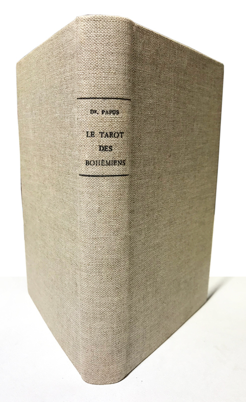
Papus (Dr Gérard Encausse) :
Clef absolue de la Science Occulte. Le Tarot des Bohémiens. Le plus ancien livre du Monde à l'usage exclusif des initiés. Troisième édition.
Paris, Durville, sans date (1911) ; in-8 ; pleine toile écrue (reliure première moitié du XXe) ; 349 pp., (6) pp. de catalogue, premier plat ocre conservé, nombreuses figures. Préface de la 2e édition.
Referentie van de boekhandelaar : 15003
|
|
|
PAPUS Dr. Gérard Encausse
TRAITÉ MÉTHODIQUE DE MAGIE PRATIQUE
Paris Editions Dangles, sans date (vers 1950) 0 in 8 (24x15) 1 fort volume broché, VIII et 639 pages, avec 113 figures dans le texte. Gérard Encausse dit Papus, 1865-1916. Troisième édition. Bel exemplaire ( Photographies sur demande / We can send pictures of this book on simple request )
Referentie van de boekhandelaar : 37851
|
|
|
PAPY Louis Photos et cartes hors texte.
Les Landes de Gascogne et la Côte d'argent.
Couverture souple. Broché. 192 pages.
Referentie van de boekhandelaar : 136967
|
|
 De zoekresultaten per email ontvangen
 Zoekresultaten downloaden als PDF
 RSS feed


