|
Roadrunner Maps Firm
The Roadrunner five county street atlas: Kitsap Jefferson Mason Thurston Lewis
Roadrunner Maps 2001-01-01. 2002 ed. Unknown Binding. Good. Roadrunner Maps unknown
Bookseller reference : SONG1884957579 ISBN : 1884957579 9781884957574
|
|
|
Rob Talbot; Robin Whiteman
The Yorkshire Moors and Dales (Country)
No marks or inscriptions. No creasing to covers or to spine. A very clean very tight copy with bright unmarked boards and no bumping to corners. 160pp. Some of England's finest examples of both natural and man-made scenery, photographed in colour by Rob Talbot and described from historical, geographical and natural perspectives by Robin Whiteman.

|
|
|
ROBBE, Jacques.
Méthode pour apprendre facilement la Géographie. Contenant un Abbrégé de la Sphère, la division de la Terre en ses Continens, Empires, Royaumes, États, Républiques, Provinces, &c. Avec les tables des villes les plus notables de chaque province. Tome Premier [sur deux].
À La Haye, chez Henri Van Bulderen, 1691. 8vo.; frontispicio grabado en cobre, 11 hojas, 575 pp., 8 hojas y 14 mapas plegados, dibujados por Nicholas de Fer (1646-1720) y grabados en cobre por De Winter. Encuadernación de época en piel, con lomera profusamente ornada. Este Tomo Primero contiene: Mapamundi, y los mapas de Europa, Francia, Imperio de Alemania, Países Bajos, Polonia, Rusia Blana, Suecia y Noruega, Dinamarca, Islas Británicas, España, Italia, Grecia (como la parte meridional de Turquía en Europa) y Hungría (como la parte septentrional de Turquía en Europa).

|
|
|
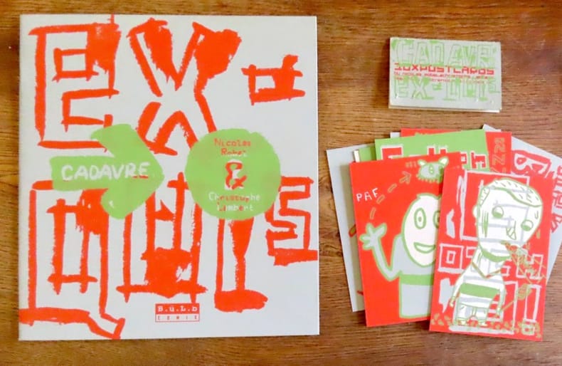
Robel Nicolas, Lambert Christophe:
Cadavre exquis / avec 10 cartes postales.
B.ü.L.b Comix, 2000. In-4 broché, couverture à grands rabats. On joint les 10 cartes au format 9 x 13 cm.
Bookseller reference : 19488
|
|
|
ROBERT Gaston
Les gais et curieux tours d'escamotage anciens et modernes, tours de gobelets et de gibecière, jeux de combinaison, d'adresse, etc. des plus célèbres professeurs.
Paris, Librairie Garnier Frères, 1938. 12 x 19, 171 pp., 74 figures, broché, bon état (1 tout petit accroc en bas de couverture).
Bookseller reference : 26217
|
|
|
ROBERT (Maurice)
Le centre africain, le domaine minier et la cuvette congolaise
Bruxelles, Maurice Lamertin, 1932 – in-8, 264 pp – broché, illustré de 10 figures et de 13 planches hors texte dont 2 en couleur
Bookseller reference : 5018
|
|
|
ROBERT ; [ VAUGONDY, Robert de ]
La Judée ou Terre Sainte divisée en ses douze Tribus. Par le Sr. Robert, Géographe du Roi, avec privilège, 1750 [Avec :] Carte de la Terre de Canaan ou Terre Promise à Abraham et à sa Postérité.
1 carte sous encadrement verre et bois au format 76 x 65 cm (format du cadre), le format apparent de la carte, sous marie-louise, est de 61 x 50,5 cm, frontières rehaussée en couleur, 1750 Bel état pour cette belle carte ancienne de Terre Sainte, déjà encadrée. A saisir. Français

|
|
|
Robert de Vaugondy Didier Pugsley William H. William Howard donor WH. Pugsley Collection of Early Canadian Maps W. H.
L'Acadie 1769 Leather Bound
2019. Leather Bound. New. Leather Binding on Spine and Corners with Golden Leaf Printing on round Spine extra customization on request like complete leather Golden Screen printing in Front Color Leather Colored book etc. Reprinted in 2019 with the help of original edition published long back 1769. This book is printed in black & white sewing binding for longer life Printed on high quality Paper re-sized as per Current standards professionally processed without changing its contents. As these are old books we processed each page manually and make them readable but in some cases some pages which are blur or missing or black spots. If it is multi volume set then it is only single volume if you wish to order a specific or all the volumes you may contact us. We expect that you will understand our compulsion in these books. We found this book important for the readers who want to know more about our old treasure so we brought it back to the shelves. Hope you will like it and give your comments and suggestions. Lang: - French. EXTRA 10 DAYS APART FROM THE NORMAL SHIPPING PERIOD WILL BE REQUIRED FOR LEATHER BOUND BOOKS. COMPLETE LEATHER WILL COST YOU EXTRA US$ 25 APART FROM THE LEATHER BOUND BOOKS. hardcover
Bookseller reference : LB1111007011000
|
|
|
Robert de Vaugondy Didier Pugsley William H. William Howard donor WH. Pugsley Collection of Early Canadian Maps W. H.
L'Acadie 1769 FULL LEATHER BOUND
2019. SUPER DELUXE EDITION. New. Antique look with Golden Leaf Printing and embossing with round Spine completely handmade bindingextra customization on request like Color Leather Colored book special gold leaf printing etc. Reprinted in 2019 with the help of original edition published long back 1769. This book is printed in black & white sewing binding for longer life Printed on high quality Paper re-sized as per Current standards professionally processed without changing its contents. As these are old books we processed each page manually and make them readable but in some cases some pages which are blur or missing or black spots. If it is multi volume set then it is only single volume if you wish to order a specific or all the volumes you may contact us. We expect that you will understand our compulsion in these books. We found this book important for the readers who want to know more about our old treasure in old look so we brought it back to the shelves. Hope you will like it and give your comments and suggestions. Lang: - French. EXTRA 10 DAYS APART FROM THE NORMAL SHIPPING PERIOD WILL BE REQUIRED. Normal Hardbound Edition is also available on request. unknown
Bookseller reference : SD1111007011000
|
|
|
Robert de Vaugondy Didier Pugsley William H. William Howard donor WH. Pugsley Collection of Early Canadian Maps W. H.
L'Acadie 1769
2019. Paperback. New. Lang: - French. Reprinted in 2019 with the help of original edition published long back 1769. This book is Printed in black & white sewing binding for longer life with Matt laminated multi-Colour Soft Cover HARDCOVER EDITION IS ALSO AVAILABLE Printed on high quality Paper re-sized as per Current standards professionally processed without changing its contents. As these are old books we processed each page manually and make them readable but in some cases some pages which are blur or missing or black spots. If it is multi volume set then it is only single volume if you wish to order a specific or all the volumes you may contact us. We expect that you will understand our compulsion in these books. We found this book important for the readers who want to know more about our old treasure so we brought it back to the shelves. Any type of Customisation is possible with extra charges. Hope you will like it and give your comments and suggestions. paperback
Bookseller reference : PB1111007011000
|
|
|
Robert de Vaugondy Didier Pugsley William H. William Howard donor WH. Pugsley Collection of Early Canadian Maps W. H.
L'Acadie 1769 Hardcover
2019. Hardcover. New. Lang: - French. Reprinted in 2019 with the help of original edition published long back 1769. This book is Printed in black & white Hardcover sewing binding for longer life with Matt laminated multi-Colour Dust Cover Printed on high quality Paper re-sized as per Current standards professionally processed without changing its contents. As these are old books we processed each page manually and make them readable but in some cases some pages which are blur or missing or black spots. If it is multi volume set then it is only single volume if you wish to order a specific or all the volumes you may contact us. We expect that you will understand our compulsion in these books. We found this book important for the readers who want to know more about our old treasure so we brought it back to the shelves. Any type of Customisation is possible with extra charges. Hope you will like it and give your comments and suggestions. hardcover
Bookseller reference : 1111007011000
|
|
|
Robert de Vaugondy Gilles Pugsley William H. William Howard donor WH. Pugsley Collection of Early Canadian Maps W. H.
Partie de l'Amerique septent qui comprend la Nouvelle France ou le Canada 1778 Leather Bound
2019. Leather Bound. New. Leather Binding on Spine and Corners with Golden Leaf Printing on round Spine extra customization on request like complete leather Golden Screen printing in Front Color Leather Colored book etc. Reprinted in 2019 with the help of original edition published long back 1778. This book is printed in black & white sewing binding for longer life Printed on high quality Paper re-sized as per Current standards professionally processed without changing its contents. As these are old books we processed each page manually and make them readable but in some cases some pages which are blur or missing or black spots. If it is multi volume set then it is only single volume if you wish to order a specific or all the volumes you may contact us. We expect that you will understand our compulsion in these books. We found this book important for the readers who want to know more about our old treasure so we brought it back to the shelves. Hope you will like it and give your comments and suggestions. Lang: - French. EXTRA 10 DAYS APART FROM THE NORMAL SHIPPING PERIOD WILL BE REQUIRED FOR LEATHER BOUND BOOKS. COMPLETE LEATHER WILL COST YOU EXTRA US$ 25 APART FROM THE LEATHER BOUND BOOKS. hardcover
Bookseller reference : LB1111007011046
|
|
|
Robert de Vaugondy Gilles Pugsley William H. William Howard donor WH. Pugsley Collection of Early Canadian Maps W. H.
Partie de l'Amerique septent qui comprend la Nouvelle France ou le Canada 1778 FULL LEATHER BOUND
2019. SUPER DELUXE EDITION. New. Antique look with Golden Leaf Printing and embossing with round Spine completely handmade bindingextra customization on request like Color Leather Colored book special gold leaf printing etc. Reprinted in 2019 with the help of original edition published long back 1778. This book is printed in black & white sewing binding for longer life Printed on high quality Paper re-sized as per Current standards professionally processed without changing its contents. As these are old books we processed each page manually and make them readable but in some cases some pages which are blur or missing or black spots. If it is multi volume set then it is only single volume if you wish to order a specific or all the volumes you may contact us. We expect that you will understand our compulsion in these books. We found this book important for the readers who want to know more about our old treasure in old look so we brought it back to the shelves. Hope you will like it and give your comments and suggestions. Lang: - French. EXTRA 10 DAYS APART FROM THE NORMAL SHIPPING PERIOD WILL BE REQUIRED. Normal Hardbound Edition is also available on request. unknown
Bookseller reference : SD1111007011046
|
|
|
Robert de Vaugondy Gilles Pugsley William H. William Howard donor WH. Pugsley Collection of Early Canadian Maps W. H.
Partie de l'Amerique septent qui comprend la Nouvelle France ou le Canada 1778
2019. Paperback. New. Lang: - French. Reprinted in 2019 with the help of original edition published long back 1778. This book is Printed in black & white sewing binding for longer life with Matt laminated multi-Colour Soft Cover HARDCOVER EDITION IS ALSO AVAILABLE Printed on high quality Paper re-sized as per Current standards professionally processed without changing its contents. As these are old books we processed each page manually and make them readable but in some cases some pages which are blur or missing or black spots. If it is multi volume set then it is only single volume if you wish to order a specific or all the volumes you may contact us. We expect that you will understand our compulsion in these books. We found this book important for the readers who want to know more about our old treasure so we brought it back to the shelves. Any type of Customisation is possible with extra charges. Hope you will like it and give your comments and suggestions. paperback
Bookseller reference : PB1111007011046
|
|
|
Robert de Vaugondy Gilles Pugsley William H. William Howard donor WH. Pugsley Collection of Early Canadian Maps W. H.
Partie de l'Amerique septent qui comprend la Nouvelle France ou le Canada 1778 Hardcover
2019. Hardcover. New. Lang: - French. Reprinted in 2019 with the help of original edition published long back 1778. This book is Printed in black & white Hardcover sewing binding for longer life with Matt laminated multi-Colour Dust Cover Printed on high quality Paper re-sized as per Current standards professionally processed without changing its contents. As these are old books we processed each page manually and make them readable but in some cases some pages which are blur or missing or black spots. If it is multi volume set then it is only single volume if you wish to order a specific or all the volumes you may contact us. We expect that you will understand our compulsion in these books. We found this book important for the readers who want to know more about our old treasure so we brought it back to the shelves. Any type of Customisation is possible with extra charges. Hope you will like it and give your comments and suggestions. hardcover
Bookseller reference : 1111007011046
|
|
|
Robert de Vaugondy Didier Pugsley William H. William Howard donor WH. Pugsley Collection of Early Canadian Maps W. H.
Partie du Canada ou se trouvent le Fleuve St. Laurent et La Nouvelle Ecosse 1769 Leather Bound
2019. Leather Bound. New. Leather Binding on Spine and Corners with Golden Leaf Printing on round Spine extra customization on request like complete leather Golden Screen printing in Front Color Leather Colored book etc. Reprinted in 2019 with the help of original edition published long back 1769. This book is printed in black & white sewing binding for longer life Printed on high quality Paper re-sized as per Current standards professionally processed without changing its contents. As these are old books we processed each page manually and make them readable but in some cases some pages which are blur or missing or black spots. If it is multi volume set then it is only single volume if you wish to order a specific or all the volumes you may contact us. We expect that you will understand our compulsion in these books. We found this book important for the readers who want to know more about our old treasure so we brought it back to the shelves. Hope you will like it and give your comments and suggestions. Lang: - French. EXTRA 10 DAYS APART FROM THE NORMAL SHIPPING PERIOD WILL BE REQUIRED FOR LEATHER BOUND BOOKS. COMPLETE LEATHER WILL COST YOU EXTRA US$ 25 APART FROM THE LEATHER BOUND BOOKS. hardcover
Bookseller reference : LB1111007011003
|
|
|
Robert de Vaugondy Didier Pugsley William H. William Howard donor WH. Pugsley Collection of Early Canadian Maps W. H.
Partie du Canada ou se trouvent le Fleuve St. Laurent et La Nouvelle Ecosse 1769 FULL LEATHER BOUND
2019. SUPER DELUXE EDITION. New. Antique look with Golden Leaf Printing and embossing with round Spine completely handmade bindingextra customization on request like Color Leather Colored book special gold leaf printing etc. Reprinted in 2019 with the help of original edition published long back 1769. This book is printed in black & white sewing binding for longer life Printed on high quality Paper re-sized as per Current standards professionally processed without changing its contents. As these are old books we processed each page manually and make them readable but in some cases some pages which are blur or missing or black spots. If it is multi volume set then it is only single volume if you wish to order a specific or all the volumes you may contact us. We expect that you will understand our compulsion in these books. We found this book important for the readers who want to know more about our old treasure in old look so we brought it back to the shelves. Hope you will like it and give your comments and suggestions. Lang: - French. EXTRA 10 DAYS APART FROM THE NORMAL SHIPPING PERIOD WILL BE REQUIRED. Normal Hardbound Edition is also available on request. unknown
Bookseller reference : SD1111007011003
|
|
|
Robert de Vaugondy Didier Pugsley William H. William Howard donor WH. Pugsley Collection of Early Canadian Maps W. H.
Partie du Canada ou se trouvent le Fleuve St. Laurent et La Nouvelle Ecosse 1769
2019. Paperback. New. Lang: - French. Reprinted in 2019 with the help of original edition published long back 1769. This book is Printed in black & white sewing binding for longer life with Matt laminated multi-Colour Soft Cover HARDCOVER EDITION IS ALSO AVAILABLE Printed on high quality Paper re-sized as per Current standards professionally processed without changing its contents. As these are old books we processed each page manually and make them readable but in some cases some pages which are blur or missing or black spots. If it is multi volume set then it is only single volume if you wish to order a specific or all the volumes you may contact us. We expect that you will understand our compulsion in these books. We found this book important for the readers who want to know more about our old treasure so we brought it back to the shelves. Any type of Customisation is possible with extra charges. Hope you will like it and give your comments and suggestions. paperback
Bookseller reference : PB1111007011003
|
|
|
Robert de Vaugondy Didier Pugsley William H. William Howard donor WH. Pugsley Collection of Early Canadian Maps W. H.
Partie du Canada ou se trouvent le Fleuve St. Laurent et La Nouvelle Ecosse 1769 Hardcover
2019. Hardcover. New. Lang: - French. Reprinted in 2019 with the help of original edition published long back 1769. This book is Printed in black & white Hardcover sewing binding for longer life with Matt laminated multi-Colour Dust Cover Printed on high quality Paper re-sized as per Current standards professionally processed without changing its contents. As these are old books we processed each page manually and make them readable but in some cases some pages which are blur or missing or black spots. If it is multi volume set then it is only single volume if you wish to order a specific or all the volumes you may contact us. We expect that you will understand our compulsion in these books. We found this book important for the readers who want to know more about our old treasure so we brought it back to the shelves. Any type of Customisation is possible with extra charges. Hope you will like it and give your comments and suggestions. hardcover
Bookseller reference : 1111007011003
|
|
|
ROBERT DE VAUGONDY (Didier)
Gouvernement général d'Orléanois. où se trouvent l'Orléanois propre, le Blaisois, le Gâtinois, et la Beauce, qui comprend le Vendômois, le Dunois, et le pays chartrain. Par le Sr Robert de Vaugondy fils
[Paris], 1753 carte in-folio (52 x 67 cm), contours rehaussés de couleurs, en feuille.
Bookseller reference : 223214
|
|
|
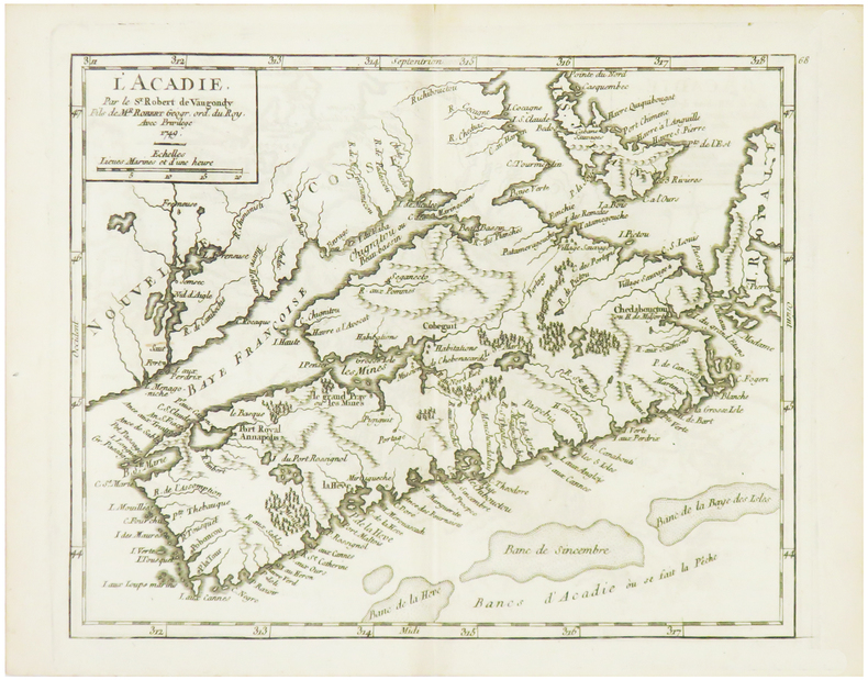
ROBERT de VAUGONDY (Didier).
[ACADIE] L'Acadie.
1749. 162 x 202 mm.
Bookseller reference : LBW024d5
|
|
|
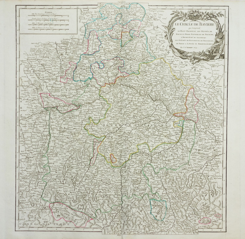
ROBERT de VAUGONDY (Didier).
[BAVIERE] Le Cercle de Bavière qui comprend le Haut Palatinat, Les duchés de Haute et Basse Bavière et de Neuburg, l'archevêché de Salzburg, les évêchés de Ratisbonne, de Freisingen, de Passaui et la prévôté de Berchtolsgaden.
vers 1768. 500 x 448 mm.
Bookseller reference : LBW-1957
|
|
|
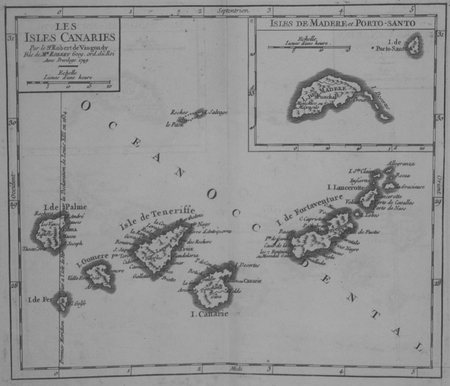
ROBERT de VAUGONDY (Didier).
[CANARIES] Les Isles Canaries.
1749. 163 x 191 mm.
Bookseller reference : LBW024fd
|
|
|
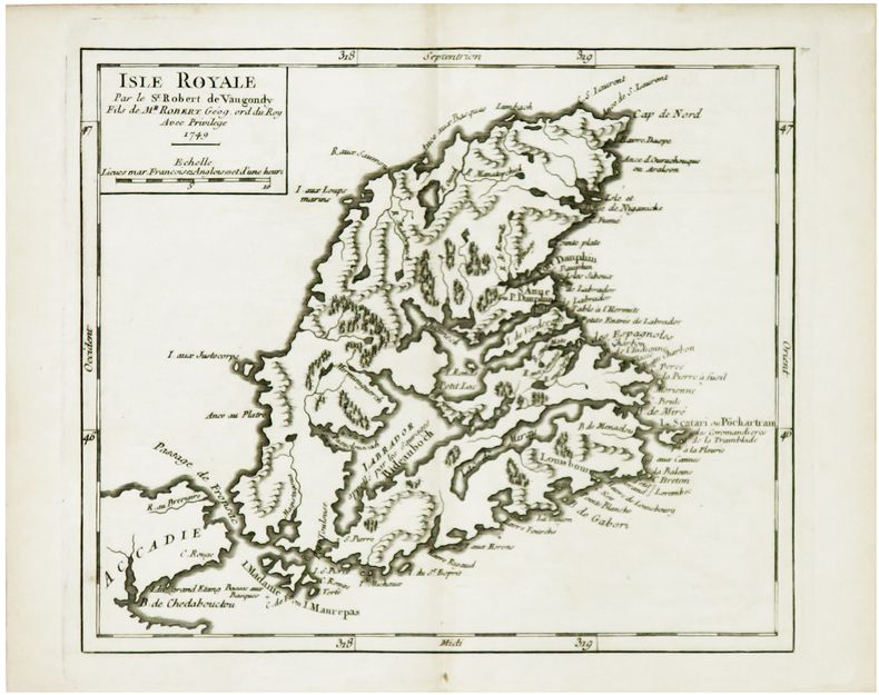
ROBERT de VAUGONDY (Didier).
[CAP-BRETON] Isle Royale.
1749. 163 x 192 mm.
Bookseller reference : LBW024d6
|
|
|
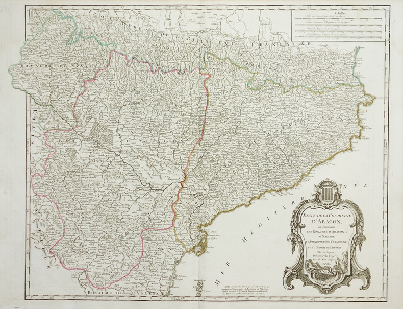
ROBERT de VAUGONDY (Didier).
[CATALOGNE] Etats de la couronne d'Aragon, où se trouvent les royaumes d'Aragon et de Navarre, la principauté de Catalogne.
vers 1780. 480 x 620 mm.
Bookseller reference : LBW-1951
|
|
|
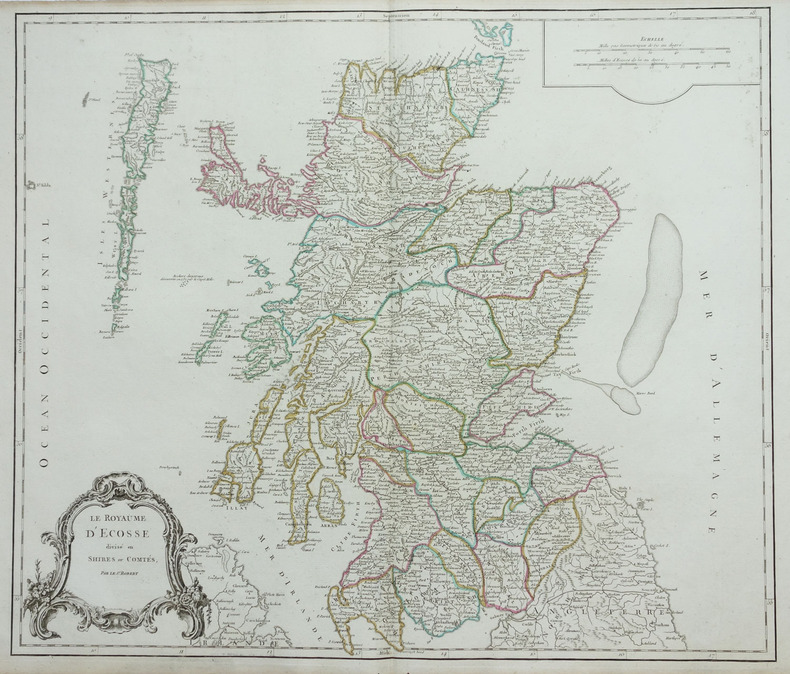
ROBERT de VAUGONDY (Didier).
[ECOSSE] Le Royaume d'Ecosse divisé en shires ou comtés.
1768. 485 x 570 mm.
Bookseller reference : LBW-1892
|
|
|
ROBERT de VAUGONDY (Didier).
[ESTONIE/LETTONIE/LITUANIE] Curlande, Livonie, Ingrie et partie méridionale de Finlande.
1748. 163 x 184 mm.
Bookseller reference : LBW027c3

|
|
|
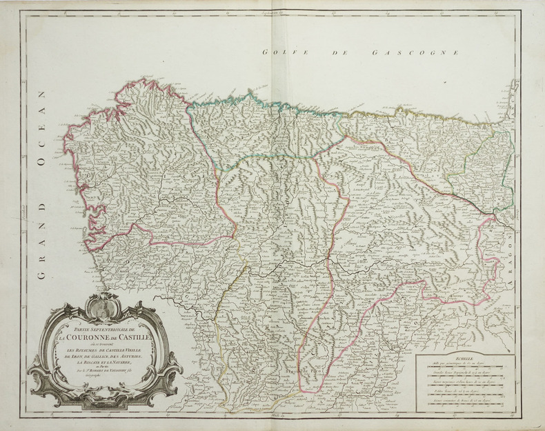
ROBERT de VAUGONDY (Didier).
[GALICE/PAYS BASQUE] Partie septentrionale de la couronne de Castille où se trouvent les royaumes de Castille Vieille, de Léon, de Gallice, des Asturies, la Biscaye et la Navarre, en partie.
vers 1768. 480 x 590 mm.
Bookseller reference : LBW-1919
|
|
|
ROBERT de VAUGONDY (Didier).
[GALICE] Partie septentrionale des états de Castille où se trouve le royaume de Gallice.
1749. 165 x 193 mm.
Bookseller reference : LBW024f5

|
|
|
ROBERT de VAUGONDY (Didier).
[GUYANE] Partie orientale de la Terre Ferme où l'on trouve la Guiane. Partie orientale du Fl. Maragnon ou Amazone.
1749. 160 x 224 mm.
Bookseller reference : LBW-4796

|
|
|
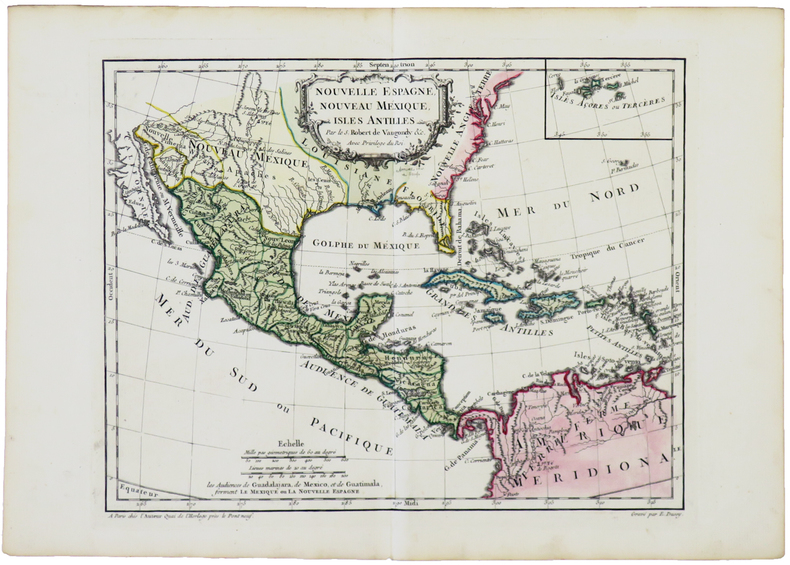
ROBERT de VAUGONDY (Didier).
[MEXIQUE] Nouvelle Espagne, Nouveau Mexique, Isles Antilles.
[1762]. 237 x 306 mm.
Bookseller reference : LBW-5041
|
|
|
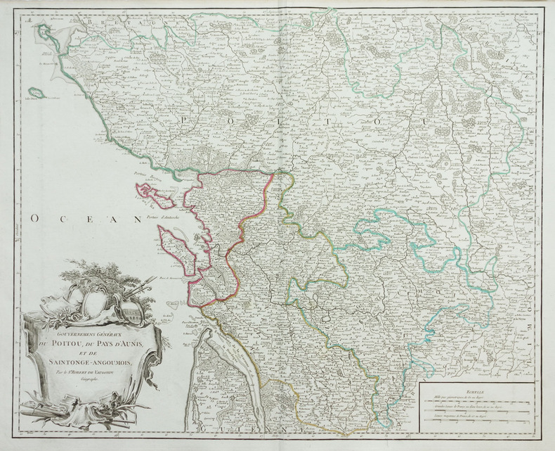
ROBERT de VAUGONDY (Didier).
[POITOU] Gouvernemens généraux du Poitou, du pays d'Aunis, et de Saintonge-Angoumois.
vers 1768. 480 x 589 mm.
Bookseller reference : LBW-1955
|
|
|
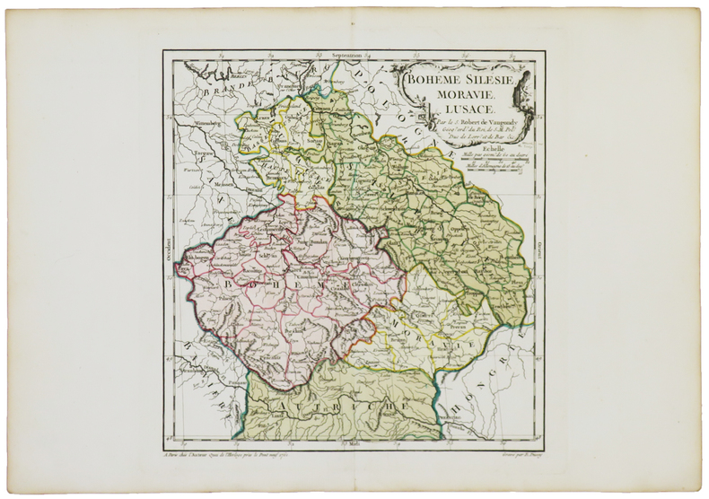
ROBERT de VAUGONDY (Didier).
[RÉPUBLIQUE TCHÈQUE] Bohême Silésie, Moravie, Lusace.
Paris, chez l'auteur, [1762]. 240 x 229 mm.
Bookseller reference : LBW-5040
|
|
|
ROBERT de VAUGONDY (Didier).
[TERRE-NEUVE] Isle de Terre-Neuve.
1749. 171 x 190 mm.
Bookseller reference : LBW024d7

|
|
|
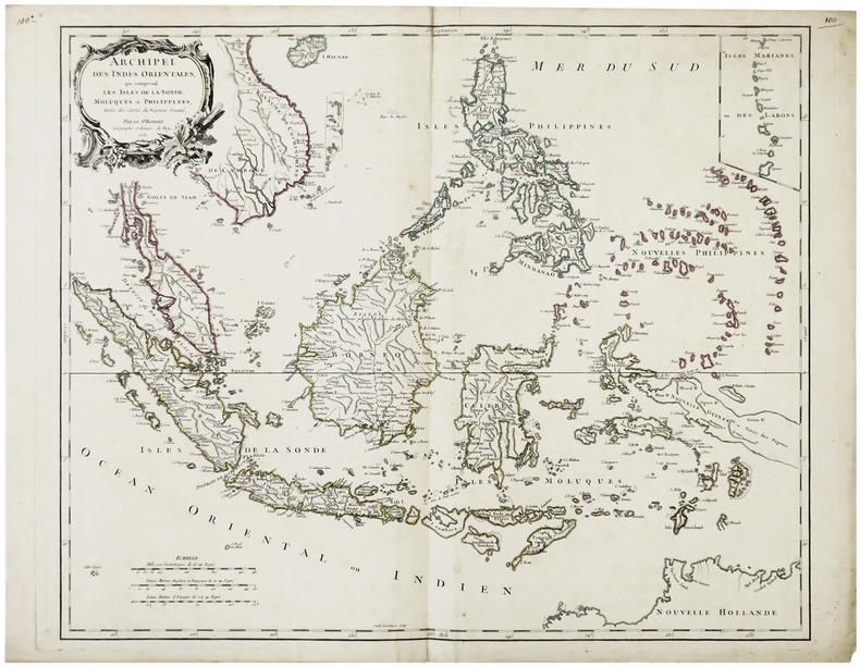
ROBERT de VAUGONDY (Didier).
Archipel des Indes Orientales, qui comprend les isles de la Sonde, Moluques et Philippines.
Venise, P. Santini, 1778. 481 x 590 mm.
Bookseller reference : LBW-795

|
|
|
ROBERT de VAUGONDY (Didier).
Archipel des Indes Orientales, qui comprend les isles de la Sonde, Moluques et Philippines.
1750. 480 x 592 mm.
Bookseller reference : LBW-6421
|
|
|
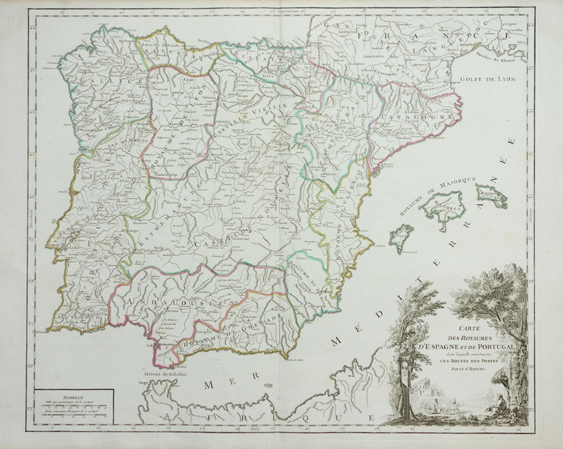
ROBERT de VAUGONDY (Didier).
Carte des royaumes d'Espagne et de Portugal dans laquelle sont tracées les routes des postes.
vers 1768. 480 x 575 mm.
Bookseller reference : LBW-1948
|
|
|
ROBERT de VAUGONDY (Didier).
Congo ou Basse Guinée.
1749. 165 x 170 mm.
Bookseller reference : LBW024c2
|
|
|
ROBERT de VAUGONDY (Didier).
Hémisphère céleste Arctique ou septentrional - Hémisphère céleste Antarctique ou austral.
Paris, Sr. Delamarche, 1763. Deux feuilles, chacune de 672 x 637 mm.
Bookseller reference : LBW-6255

|
|
|
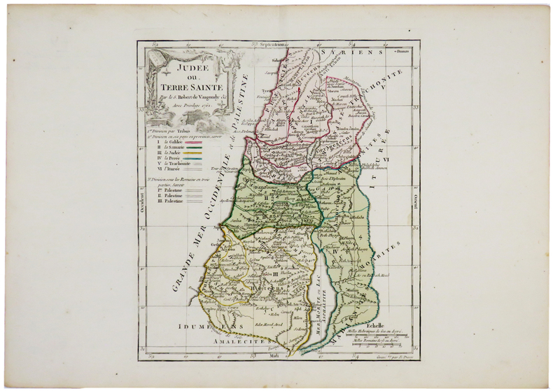
ROBERT de VAUGONDY (Didier).
Judée ou Terre Sainte.
Paris, chez l'auteur, 1762. 242 x 213 mm.
Bookseller reference : LBW-5143
|
|
|
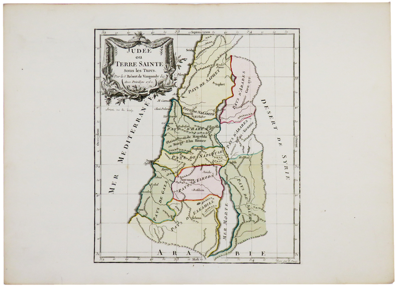
ROBERT de VAUGONDY (Didier).
Judée ou Terre Sainte.
Paris, chez l'auteur, 1762. 242 x 214 mm.
Bookseller reference : LBW-5171

|
|
|
ROBERT de VAUGONDY (Didier).
Judée ou Terre Sainte.
Paris, chez l'auteur, 1762. 241 x 212 mm.
Bookseller reference : LBW-5174
|
|
|
ROBERT de VAUGONDY (Didier).
Judée ou Terre Sainte.
Paris, chez l'auteur, 1762. 242 x 214 mm.
Bookseller reference : LBW-5187

|
|
|
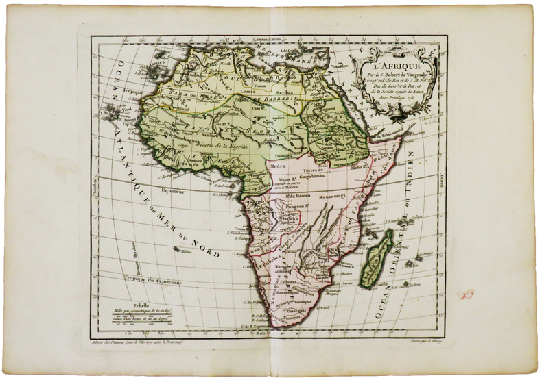
ROBERT de VAUGONDY (Didier).
L'Afrique.
Paris, chez l'auteur, [1762]. 238 x 280 mm.
Bookseller reference : LBW-4994
|
|
|
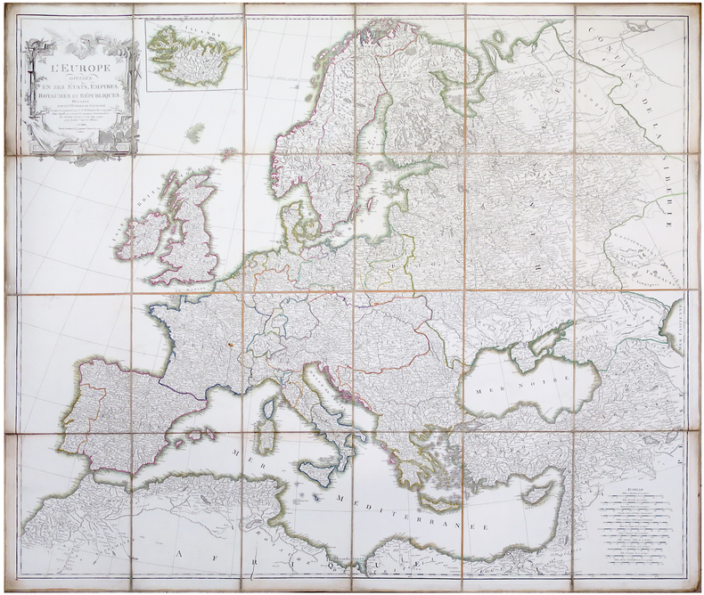
ROBERT de VAUGONDY (Didier).
L'Europe divisée en ses états, empires, royaumes et républiques.
Paris, C.F. Delamarche, [circa 1805]. En 24 sections montées sur toile et pliées, formant une carte de 1 x 1,14 m.
Bookseller reference : LBW-6489
|
|
|
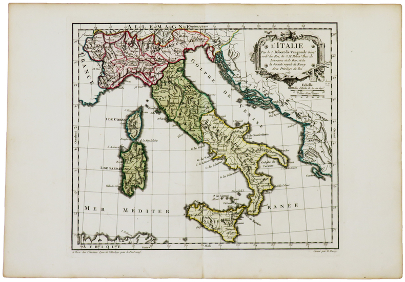
ROBERT de VAUGONDY (Didier).
L'Italie.
Paris, chez l'auteur, [1762]. 240 x 280 mm.
Bookseller reference : LBW-5043
|
|
|
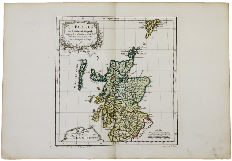
ROBERT de VAUGONDY (Didier).
L'Écosse.
Paris, chez l'auteur, 1762. 238 x 223 mm.
Bookseller reference : LBW-5022
|
|
|
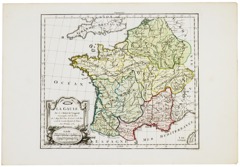
ROBERT de VAUGONDY (Didier).
La Gaule.
Paris, chez l'auteur, 1762. 239 x 276 mm.
Bookseller reference : LBW-5188
|
|
|
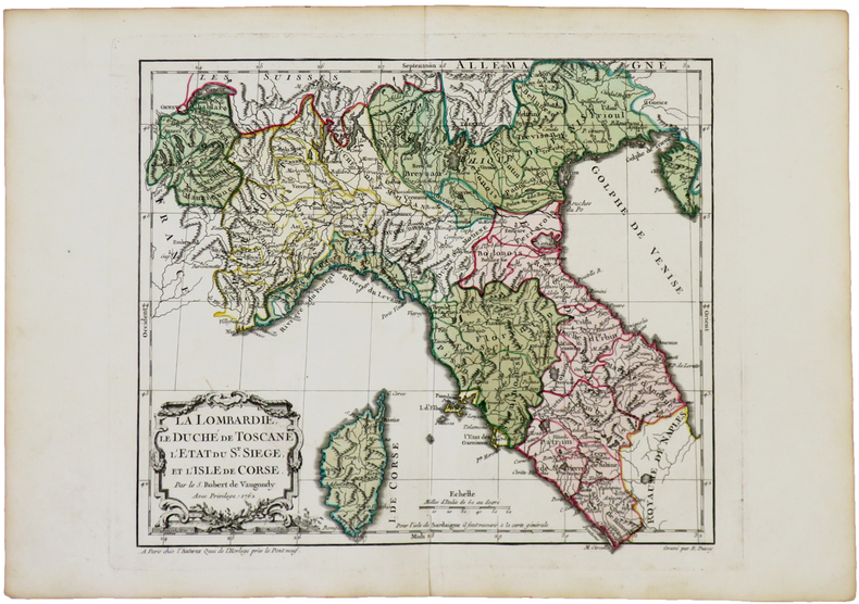
ROBERT de VAUGONDY (Didier).
La Lombardie, le Duché de Toscane, l'État du St. Siège, et l'isle de Corse.
Paris, chez l'auteur, 1762. 239 x 280 mm.
Bookseller reference : LBW-5044
|
|
|
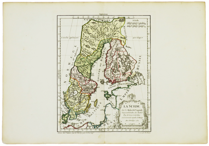
ROBERT de VAUGONDY (Didier).
La Suède.
Paris, chez l'auteur, 1762. 238 x 190 mm.
Bookseller reference : LBW-5024
|
|
 Receive by email
 Download as PDF document
 RSS feed


