|
Trails Illustrated Maps
Rocky Mountain National Park Hiking Map
2016-06-06. New. Ships with Tracking Number! INTERNATIONAL WORLDWIDE Shipping available. May be re-issue. Buy with confidence excellent customer service! unknown
Bookseller reference : 1566953421n ISBN : 1566953421 9781566953429

|
|
|
Trails Illustrated Maps
Rocky Mountain National Park Hiking Map
Natl Geographic Society Maps 2008-04-01. 4. Map. Used:Good. Natl Geographic Society Maps unknown
Bookseller reference : DADAX1566953421 ISBN : 1566953421 9781566953429

|
|
|
Trails Illustrated Maps
Staunton/Shenandoah Mountain George Washington National Forest Hiking Map
2007-02-08. New. Ships with Tracking Number! INTERNATIONAL WORLDWIDE Shipping available. May be re-issue. Buy with confidence excellent customer service! unknown
Bookseller reference : 156695374Xn ISBN : 156695374x 9781566953740

|
|
|
Trails Illustrated Maps
Staunton/Shenandoah Mountain George Washington National Forest Hiking Map
National Geographic 2009-04-01. Map Rev. Map. Used:Good. National Geographic unknown
Bookseller reference : DADAX156695374X ISBN : 156695374X 9781566953740

|
|
|
Trakker Maps Inc.
American Map Indian River St. Lucie and Martin Counties Fl Street Atlas
2004-08-08. Good. Ships with Tracking Number! INTERNATIONAL WORLDWIDE Shipping available. May not contain Access Codes or Supplements. May be re-issue. May be ex-library. Shipping & Handling by region. Buy with confidence excellent customer service! unknown
Bookseller reference : 0875305458 ISBN : 0875305458 9780875305455

|
|
|
Trakker Maps Inc
American Map Indian River St. Lucie and Martin Counties Fl Street Atlas
Adc the Map People 2004-03. Paperback. Good. Adc the Map People paperback
Bookseller reference : SONG0875305458 ISBN : 0875305458 9780875305455

|
|
|
Trakker Maps Inc
Florida Gold Coast Atlas: Covering Dade Broward and Palm Beach Counties
Trakker Maps. Used - Good. Shows some signs of wear and may have some markings on the inside. Trakker Maps unknown
Bookseller reference : GRP104816174 ISBN : 1877651001 9781877651007
|
|
|
Trakker Maps Staff
Florida Travel Guide
Trakker Maps Incorporated 1998. Paperback. Good. Disclaimer:A copy that has been read but remains in clean condition. All pages are intact and the cover is intact. The spine may show signs of wear. Pages can include limited notes and highlighting and the copy can include previous owner inscriptions. At ThriftBooks our motto is: Read More Spend Less.Dust jacket quality is not guaranteed. Trakker Maps, Incorporated paperback
Bookseller reference : G1579520510I3N00 ISBN : 1579520510 9781579520519
|
|
|
Trakker Maps Inc
Martin County Fl Map
Trakker Maps 2004-07-15. 3. Paperback. Used:Good. Trakker Maps paperback
Bookseller reference : DADAX0875305032 ISBN : 0875305032 9780875305035
|
|
|
Trakker Maps Inc
Martin County Fl Map
Trakker Maps 2004-07-15. Paperback. Good. Trakker Maps paperback
Bookseller reference : SONG0875305032 ISBN : 0875305032 9780875305035
|
|
|
Trakker Maps Staff
Myrtle Beach SC Atlas
ADC The Map People 2004. Paperback. Very Good. Disclaimer:A copy that has been read but remains in excellent condition. Pages are intact and are not marred by notes or highlighting but may contain a neat previous owner name. The spine remains undamaged. At ThriftBooks our motto is: Read More Spend Less.Dust jacket quality is not guaranteed. ADC The Map People paperback
Bookseller reference : G0875304834I4N00 ISBN : 0875304834 9780875304830

|
|
|
Trakker Maps Inc
Myrtle Beach South Carolina: Street Atlas
ADC The Map People 2004-02. Paperback. Good. ADC The Map People paperback
Bookseller reference : SONG0875304834 ISBN : 0875304834 9780875304830
|
|
|
Trakker Maps Inc. Editor
Naples Fort Myers and Cape Coral
Trakker Maps 1998-11-01. Paperback. Very Good. Ships Out Tomorrow! Trakker Maps paperback
Bookseller reference : 160531141 ISBN : 0875305024 9780875305028

|
|
|
Trakker Maps Staff
Orlando Area Atlas : Seminole Orange and Osceola Counties
Trakker Maps Incorporated 1998. Paperback. Acceptable. Disclaimer:A readable copy. All pages are intact and the cover is intact. Pages can include considerable notes-in pen or highlighter-but the notes cannot obscure the text. At ThriftBooks our motto is: Read More Spend Less.Dust jacket quality is not guaranteed. Trakker Maps, Incorporated paperback
Bookseller reference : G1877651680I5N00 ISBN : 1877651680 9781877651687

|
|
|
Trakker Maps Inc
Orlando Area: Seminole Orange and Osceola Counties Atlas
acceptable. spiral bound paperback. cover and corner wear. bent page corners. creased covers. bent spirals. paperback
Bookseller reference : B80513xxxN23323 ISBN : 1877651680 9781877651687
|
|
|
Trakker Maps Inc. Editor
Trakker Greater Charleston S.C. Street Atlas: Covering Daniel Island Edisto Beach Folly Beach Goose Creek Hanahan Isle of Palms.
Trakker Maps Inc 2000-08-01. Paperback. Very Good. Pages are clean & unmarked. The cover is bright & clean with edge-wear around the spine. There is a crease on the top right of the front cover and a crease on the top left of the back cover. The stapled binding is still tight. Solid copy. FAST SHIPPING & FREE TRACKING! Trakker Maps Inc paperback
Bookseller reference : 182086 ISBN : 1579520812 9781579520816
|
|
|
Trakker Maps Staff
Trakker Tampa Street Atlas: Bloomingdale Brandon Carollwood Lutz Mango Northdale Orient Park Palm River Plant City Sun City Temple Terra
Trakker Maps Inc. Used - Good. Shows some signs of wear and may have some markings on the inside. Trakker Maps Inc unknown
Bookseller reference : GRP96776519 ISBN : 1579520669 9781579520663
|
|
|
Trakker Maps Inc. Editor
Union/Hudson/Essex Counties Atlas
Hagstrom Map Co 1999-09-01. Paperback. Good. Used copy. Pages are laminated. A few of the last pages have wear and light soiling. Wear to the exterior with bumping and a few tears along the edges of both covers. Usable copy. Hagstrom Map Co paperback
Bookseller reference : 112818026 ISBN : 0880976403 9780880976404

|
|
|
Trakker Maps Inc
West Palm Beach FL Pocket Map
Trakker Maps 2006-01. Map. Good. Trakker Maps unknown
Bookseller reference : SONG0875305288 ISBN : 0875305288 9780875305288
|
|
|
TRAMEZINO o TRAMEZINI Francesco & Michele
Anteiquae Urbis Imago Accuratissime ex Vetusteis Monumenteis Formata
Pianta archeologica a proiezione verticale, con rappresentazione in alzato degli edifici antichi. Disegnata ed ideata da Pirro Ligorio, viene incisa da Jacob Bos per l’editore Tramezzino. Si tratta della grande pianta archeologica del Ligorio, frutto della sua valente esperienza di archeologo, che ebbe una grande influenza sulla produzione topografica della città per oltre due secoli. Per elaborare questa pianta, si avvalse della sua profonda conoscenza archeologica delle rovine di Roma, delle fonti classiche e di una vasta documentazione costituita da iscrizioni, bassorilievi e monete antiche. Per la parte topografica il Ligorio si basa sulla pianta del Bufalini del 1551.Roma entro le mura appare come un fantasioso insieme di edifici, alcuni noti e ancora presenti e altri che, sebbene localizzati con una certa esattezza, indubbiamente sono frutto di ricostruzioni abbastanza fantasiose. Non mancano gli errori di localizzazione, come ad esempio il Foro Romano, erroneamente collocato tra il Campidoglio ed il Palatino. Il primo stato della carta è noto solo attraverso gli esemplari conservati al British Museum e alla Philadelphia Library Company. La carta ebbe una ristampa inalterata, circa un secolo dopo per mano di Gian Battista de Rossi. Dopo un altro secolo circa (1773) anche Carlo Losi ne realizza una ristampa dalle lastre originali, che poi furono acquisite da Giovanni Scudellari e ristampate verso il 1820/30.In alto, lungo il bordo superiore, è impresso il titolo: ANTEIQUAE URBIS IMAGO ACCURATISSIME EX VETUSTEIS MONUMENTEIS FORMATA. Nel cartiglio all’angolo superiore sinistro si legge: EFFIGIES ANTIQUAE ROMAE EXVESTIGIIS AEDIFICIORUM RUINIS TESTIMONIO VETERUM AUCTORUM FIDE NUMISMATUM MONUMENTIS AENEIS PLUMBAEIS SAXEIS TIGLINISQUE COLLECTA ATQUE IN HANC TABELLAM REDACTA ATQUE DESCRIPTA A PYRRHO LIGORIO ROMANO PER XIIII REGIONES IN QUAS URBEM DIVISIT IMP CAESAR. AUG. PIOQUE IIII PONT MAX DICATA EXCUDERUNT ROMAE MICHAEL ET FRANCISCUS TRAMEZZINI M.D.LXI. Seguono l’indicazione del privilegio e la firma dell’incisore: Cum privilegio Sum[m]i Pont[ificis] et Senat[us] Venet[iani]. Iacobus Bossius belga incidebat. Orientazione fornita dal punto cardinale SEPTENTRIONE, indicazione collocata nell’angolo in alto a sinistra; il nord-est è in alto. Nella tavola alcuni monumenti e luoghi sono evidenziati attraverso il toponimo.Bulino, stampato su dodici fogli, applicati su tela e più volte ripiegati. Esemplare nel quarto stato finale, della tiratura Scudellari, finemente colorato a mano.Bibliografia:Bifolco - Ronca, Cartografia e Topografia italiana del XVI secolo (2018), pp. 2341-2342, tav. 1207, IV/IV; Destombes (1970): n. 94; Bevilacqua-Fagiolo (2012): p. 25; Caldana (2013): p. 22 e n. I.7; Frutaz (1962): n. XVIIa-b e tavv. 671-684; Hülsen (1915): VIII, pp. 52-53, nn. 31-35; Hülsen (1933): pp. 105-106, VIII; Karrow (1993): n. 51/11 e 51/11.4-51/11.7; Mandowsky-Mitchell (1963): tavv. 75-76; Scaccia Scarafoni (1939: nn. 11-13. Archaeological map with vertical projection, with representation in elevation of ancient buildings. Designed and conceived by Pirro Ligorio, it is engraved by Jacob Bos for the publisher Tramezzino. It is the great archaeological plant of Ligorio, the result of his valuable experience as an archaeologist, which had a great influence on the topographic production of the city for over two centuries. In order to elaborate this plan, he used his deep archaeological knowledge of the ruins of Rome, classical sources and a vast documentation consisting of inscriptions, bas-reliefs and ancient coins. For the topographic part Ligorio is based on the map by Bufalini of 1551.Rome within the walls appears as a fanciful set of buildings, some of them known and still present and others that, although located with a certain accuracy, are undoubtedly the result of quite fanciful reconstructions. There is no lack of localization errors, such as the Roman Forum, erroneously located between the Capitol and the Palatine Hill. The first state of the map is known only through the examples preserved at the British Museum and the Philadelphia Library Company. The ma was reprinted unchanged, about a century later by Gian Battista de Rossi. After another century or so (1773) Carlo Losi also made a reprint from the original plates, which were then acquired by Giovanni Scudellari and reprinted around 1820/30.At the top, along the upper edge, is engraved the title: ANTEIQUAE URBIS IMAGO ACCURATISSIME EX VETUSTEIS MONUMENTEIS FORMATA. In the cartouche in the upper left: EFFIGIES ANTIQUAE ROMAE EXVESTIGIIS AEDIFICIORUM RUINIS TESTIMONIO VETERUM AUCTORUM FIDE NUMISMATUM MONUMENTS AENEIS PLUMBAEIS SAXEIS TIGLINISQUE COLLECTA ATQUE IN HANC TABELLAM REDACTA ATQUE DESCRIPTA A PYRRHO LIGORIO ROMANO PER XIIII REGIONES IN QUAS URBEM DIVISIT IMP CAESAR. AUG. PIOQUE IIII PONT MAX DICATA EXCUDERUNT ROMAE MICHAEL ET FRANCISCUS TRAMEZZINI M.D.LXI. Follow the indication of the privilege and the signature of the engraver: Cum privilegio Sum[m]i Pont[ificis] et Senat[us] Venet[iani]. Iacobus Bossius Belgian incidebat. Orientation provided by the cardinal point SEPTENTRION, indication located in the upper left corner; the northeast is at the top. Engraving, printed on twelve sheets, applied on canvas and folded several times. Exemple in the fourth final state, of the edition by Scudellari. Literature:Bifolco - Ronca, Cartografia e Topografia italiana del XVI secolo (2018), pp. 2341-2342, tav. 1207, IV/IV; Destombes (1970): n. 94; Bevilacqua-Fagiolo (2012): p. 25; Caldana (2013): p. 22 e n. I.7; Frutaz (1962): n. XVIIa-b e tavv. 671-684; Hülsen (1915): VIII, pp. 52-53, nn. 31-35; Hülsen (1933): pp. 105-106, VIII; Karrow (1993): n. 51/11 e 51/11.4-51/11.7; Mandowsky-Mitchell (1963): tavv. 75-76; Scaccia Scarafoni (1939: nn. 11-13. Bifolco - Ronca, Cartografia e Topografia italiana del XVI secolo (2018), pp. 2341-2342, tav. 1207, IV/IV.

|
|
|
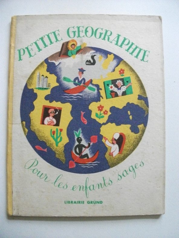
TRANCHANT Maurice
petite géographie pour tous les enfants sages
petit in 8 cartonné,dos pincé jaune,couverture illustrée en couleurs,titre illustré en couleurs 24 pages,20 charmantes illustrations en couleurs pleine page,ainsi qu’une double page de Maurice TRANCHANT Gründ éditeur 1947 Bon exemplaire,coloris frais
Bookseller reference : 6237
|
|
|
Tranie Jean text/Carmigniani Juan Carlos/de Beaufort Louisillus/Colonel Michalon maps
Napoleon et L'Autriche la Campagne de 1809 Napoleon and the Austrian Campaign of 1809
Marseille: Copernic 1979. 1st edition. VG/Good dust jacket 2 inch tear bottom rear of dust jacket taped tear head of dust jacket spine. 240 p. photos color/bw illus maps illus endsheets appendices biblio square 4to TEXT IN FRENCH; Copernic hardcover
Bookseller reference : 64530 ISBN : 2859840443 9782859840440

|
|
|
TREMAINE Jon
Tours de cartes. Collection : Image par image.
Paris, Solar, 1995. 24 x 27, 125 pp., très nombreuses illustrations en couleurs, cartonnage d'édition imprimé, bon état.
Bookseller reference : 37107
|
|
|
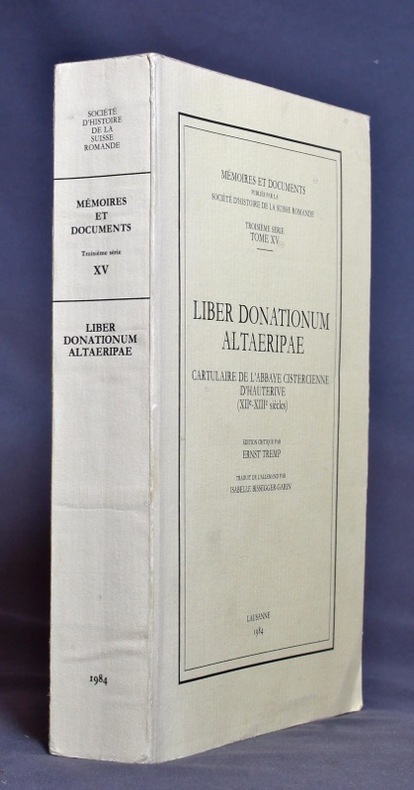
TREMP Ernst:
Liber donationum altaeripae. Cartulaire de l’abbaye cistercienne d’Hauterive (XIIe - XIIIe siècles).
Lausanne, Société d’histoire de la Suisse romande, 1984. In-8 broché de XII-433 pages, couverture imprimée.
Bookseller reference : 1149
|
|
|
Trent, Christopher
Motoring on Regional Byways : Midland England : 50 Miles from Birmingham
Ex-library copy with usual (mininal) marks and stamps - to front end paper and reverse of title page only. Mainly clean tight pages with bright unmarked tape-free boards, dusty page edges and no bumping to corners. Dust jacket not price clipped or marked or torn or creased with minor traces of handling. 144pp. Many places deserving of exploration within fifty miles motoring of Birmingham.

|
|
|
Trezise Percy; Brook Valda maps.
Dream Road: A Journey of Discovery: A Unique Insight into Aboriginal Culture Legends and Rock Art.
Sydney St Leonards: Allen & Unwin 1993. 1st ed. Hardback octavo dustjacket very good condition in very good dustjacket black & white & colour illustrations spine ends & covers corners little rubbed spine little faded minor edgewear jacket top edge lightly foxed. 205 pp. The first definitive work on the Quinkin art body. The rock art covers the caves and cliffs of Cape York peninsula. The paintings range in age from 5000 to over 13000 years and it is one of the largest and most spectacular groups of rock paintings in the world. The author is a leading expert on Australian rock art and he writes about the history and the significance of the paintings he rediscovered over a period of many years. Percy was joined by his friend Dick Roughsey a member of the Lardil tribe on Mornington Island in the Gulf of Carpentaria who helped him to learn about the culture and history of rock artists. He was able to link the paintings with the legends behind them. Percy Trezise has created many children's books about these legends. This book will interest anyone wanting to learn about the heritage of Australian art and culture. Allen & Unwin hardcover
Bookseller reference : 29234 ISBN : 1863734031 9781863734035
|
|
|
Trigiani, Elaine
Top 10 Sicily (revised edition)
No marks or inscriptions. No creasing to covers or to spine. A lovely clean crisp very tight copy with bright covers and no bumping to corners. 160pp. The self-wraps open up to present a map of the island (front) and a map of Central Palermo (rear). This is the revised edition of the guide to the 10 best of everything in Sicily, eg, beaches, resorts, sights, restaurants, etc.

|
|
|
Tring Urban District Council
Tring Urban District : The Official Guide
No marks or inscriptions. Minor creasing to covers adjacent to spine. A very clean very tight booklet with bright unmarked boards and no bumping to corners. Large fold-out street plan and map on rear in excellent condition. 40pp. Official guide the the Hertfordshire town of Tring with history, Local Authority information and photographs of the town in the early 1970s. Extremely scarce.

|
|
|
TRINQUIER (Jean).
[LAVAUR] Diocèse de Lavaur.
Paris, H. Jaillot, 1683. 351 x 451 mm.
Bookseller reference : LBW-2754

|
|
|
Tripp:
Petite sérigaphie couleurs.
2012 Sérigraphie au format 20 x 12.
Bookseller reference : 984

|
|
|
TROUVE (Claude-Joseph, baron).
ESSAI HISTORIQUE SUR LES ETATS-GENERAUX DE LA PROVINCE DE LANGUEDOC, avec cartes et gravures. [&] DESCRIPTION GENERALE ET STATISTIQUE DU DEPARTEMENT DE L'AUDE. Avec cartes et gravures. 2 volumes
1818 A Paris, Firmin Didot, 1818. Deux volumes in-quarto (215 X 269) broché TOME I : XIX (dont faux-titre et titre), 584 pages, frontispice " Armoiries des Etats de Languedoc " (relié entre les pages 328 et 329), 2 cartes, 2 plans et un tableau dépliants ; TOME II : frontispice (Blasons), VIII (dont faux-titre et titre), carte dépliante gravée couleurs de l'Aude, 679 pages (" errata " au verso du dernier feuillet), 3 vues et 2 plans. EDITION ORIGINALE de ce remarquable ouvrage complet en deux volumes, qui comprend notamment une CARTE en couleurs gravée et TROIS GRANDES PLANCHES dépliantes représentant la grande vue de Carcassonne avec le plan de la Cité, la vue générale de Castelnaudary et celle de Narbonne. Le premier volume contient une étude historique depuis la conquête romaine, la description des différents diocèses du Languedoc et enfin l'histoire des ouvrages publics et des canaux. Le second volume donne une étude très détaillée de l'Aude comprenant la topographie, géologie, description des villes et villages, population, moeurs, agriculture, industrie, commerce, pêche, etc. Claude-Joseph, baron TROUVE (1768-1860), fut le deuxième préfet de l'Aude, succédant à Barante. Très soucieux de sa mission administrative, il organise en 1807 un recensement démographique et agricole détaillé, fait exécuter plusieurs enquêtes sur l'industrie et l'école, crée un réseau de correspondants qui alimentent peu à peu sa future " Description générale et statistique du département de l'Aude " (Les Audois, Dictionnaire biographique sous la direction de R. CAZALS & D. FABRE, 328).
Bookseller reference : 1806
|
|
|
TRULLEN, Pablo [Comisario].
La Cartografía de Aragón. Primera Muestra de Documentación Histórica Aragonesa.
Zaragoza, 1988. Folio; 79 pp., 4 hs. Con 24 láminas. Cubiertas originales.

|
|
|
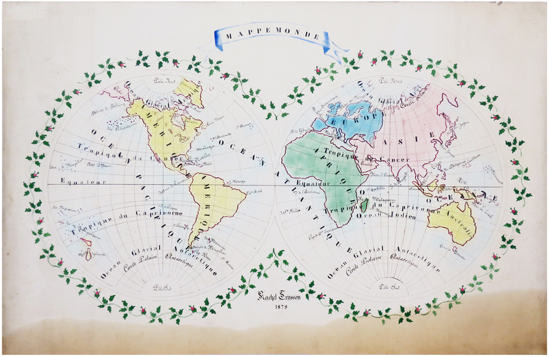
TRUSSON (Rachel).
Mappemonde.
1878. 61 x 90 cm.
Bookseller reference : LBW-6628
|
|
|
TSCHUDI, Iwan von:
Der Tourist in der Schweiz nebst Grenzgebieten. Reisetaschenbuch. 36., neu bearb. Auflage v. C. Täuber. In 3 Bden.
Zürich, Orell Füssli, 1921, 21, 22, kl. in-8°, ca. 600 S., mit Karten ill., grüner Original-Leinenband.
Bookseller reference : 56401aaf
|
|
|
TSCHUDI, Iwan von:
Der Tourist in der Schweiz nebst Grenzgebieten. Reisetaschenbuch. 34., neu bearb. Auflage. In 3 Bde.
Zürich, Orell Füssli, 1899, kl. in-8°, 534 S., mit vielen Karten, Gebirgsprofilen und Stadtplänen, roter Original-Leinenband, Schuber.
Bookseller reference : 90011aaf
|
|
|
TSCHUDI, Iwan von:
Der Tourist in der Schweiz und Grenzgebieten. Reisetaschenbuch. 35., neu bearb. Auflage v. C. Täuber. In 3 Bden.
Zürich, Orell Füssli, 1918, kl. in-8°, ca. 600 S., mit vielen Karten, Gebirgsprofilen und Stadtplänen illustriert, Original-Leinenbde
Bookseller reference : 119935aaf
|
|
|
TSCHUDI, Iwan von:
Der Tourist in der Schweiz und Grenzgebieten. Reisetaschenbuch. 36., neu bearb. Auflage v. C. Täuber. In 3 Bden.
Zürich, Orell Füssli, 1921, kl. in-8°, ca. 600 S., mit vielen Karten, Gebirgsprofilen und Stadtplänen illustriert, Original-Leinenbde.
Bookseller reference : 119936aaf
|
|
|
TSCHUDI, Iwan von:
Der Turist in der Schweiz und den Grenzrayons. Reisetaschenbuch. 33., neu bearb. Auflage.
Zürich, Orell Füssli, 1895, kl. in-8°, 6 gelbe Blätter (Werbung & Index) + XXXIV + 534 S. + 9 gefalt. Panoramas + 6 gefalt. Stadtplänen + 11 Karten, und als Vorsatz hinten 1 Doppelblattgrosses Routekärtchen der Schweiz + 1 gef. Touristenkarte der Schweiz am Schlussedes Buches, roter Original-Leinenband, Schönes Exemplar.
Bookseller reference : 137129aaf
|
|
|
TT Maps
Rajasthan
Ttmaps Publications. Used - Good. Shows some signs of wear and may have some markings on the inside. Ttmaps Publications unknown
Bookseller reference : GRP117680192 ISBN : 8170530180 9788170530183
|
|
|
Tt Maps & Publications Private Ltd Oxford University Press Editor
A Social and Economic Atlas of India
Oxford University Press USA 1988-06-02. Hardcover. Used:Good. Oxford University Press, USA hardcover
Bookseller reference : DADAX0195620410 ISBN : 0195620410 9780195620412
|
|
|
Tt Maps & Publications Private Ltd; Editor Oxford University Press
A Social and Economic Atlas of India
Oxford University Press USA 1988-06-02. Hardcover. Good. Oxford University Press, USA hardcover
Bookseller reference : SONG0195620410 ISBN : 0195620410 9780195620412
|
|
|
TT. Maps & Publications Ltd
A ttk atlas to India's wildlife TTK discover India series
TT. Maps & Publications Limited 1991. Good. TT. Maps & Publications Limited unknown
Bookseller reference : SONG8170531322 ISBN : 8170531322 9788170531326
|
|
|
TT. Maps & Publications Ltd
Andhra Pradesh TTK discover India series
TT. Maps & Publications Private. Used - Good. Shows some signs of wear and may have some markings on the inside. TT. Maps & Publications Private unknown
Bookseller reference : GRP79842039 ISBN : 817053013x 9788170530138
|
|
|
TT. Maps & Publications Ltd
Karnataka TTK discover India series
TT. Maps & Publications Ltd. Used - Good. Ships from Reno NV. Shows some signs of wear and may have some markings on the inside. 100% Money Back Guarantee. Shipped to over one million happy customers. Your purchase benefits world literacy! TT. Maps & Publications Ltd unknown
Bookseller reference : GRP104655864 ISBN : 8170530008 9788170530008
|
|
|
Tucazinsky, Nissan Aharon
The Borders of the Holy Land: Jerusalem in Pictures [IN HEBREW] Supplement to the Book "The Holy City & Temple"
In Hebrew. 180X250 mm. 43+4+12 + 55 Plates. Gilt Hard cover with dust jacket. Dust Jacket slightly torn on the upper edge. Cover and spine slightly worn. Yellow pages. Name of previous owner written on the first white page and on title page. Else in good condition. Includes Maps, Photos and Illustrations.
|
|
|
Tucker Glenn; maps by Dorothy Thomas Tucker
Dawn Like Thunder: The Barbary Wars and the Birth of the U.S. Navy
Indianapolis: Bobbs-Merrill 1963. 1st. Hardcover. Book fine Dust jacket fine. The dust jacket is price clipped and has minor chips and closed tears to the extremities. <br/><br/> Bobbs-Merrill hardcover
Bookseller reference : 9010503
|
|
|
Tucker Glenn; Tucker WT. maps by; W. T.
Poltroons and Patriots: A Popular Account of the War of 1812 2 Volumes
Indianapolis and New York: The Bobbs-Merrill Company Inc. Publishers 1954. First Edition. Hardcover. Octavo; pp 812; Good; blue/red spines with gilt text; no jackets; 2 volumes; cloths have modest sun fading to exteriors; strong boards; text block shows lightly toned exterior edges; frontispieces; deckled fore edges; interiors clean; illustrated;. FP New Rockville Stock. <br/><br/> The Bobbs-Merrill Company, Inc., Publishers hardcover
Bookseller reference : 15-19-1321260
|
|
|
Tucker Glenn; Tucker Maps WT. W. T.
Poltroons and Patriots: A Popular Account of the War of 1812 Two volumes
Bobbs-Merrill. Tucker Glenn. Poltroons and Patriots: A Popular Account of the War of 1812 Two volumes. Tucker Maps W.T. Indianapolis: Bobbs-Merrill 1954. 812pp. Indexed. Illustrated. 8vo. Cloth with gilt lettering. Book condition: Very good with lightly bumped and yellowed spines. Slipcase is very good with light rubbing and yellowing. Includes monthly bulletin of American History Publication Society. . Very Good. 1954. Bobbs-Merrill hardcover
Bookseller reference : UTUCPOL00JMJ
|
|
|
Tucker Glenn; maps by Dorothy Thomas Tucker
Dawn Like Thunder: The Barbary Wars and the Birth of the U.S. Navy
Indianapolis: Bobbs-Merrill 1963. 1st. Hardcover. Book fine Dust jacket fine. The dust jacket is price clipped and has minor chips and closed tears to the extremities. <br/><br/> Bobbs-Merrill hardcover books
Bookseller reference : 9010503
|
|
|
Tucker Glenn; Tucker Maps WT. W. T.
Poltroons and Patriots: A Popular Account of the War of 1812 Two volumes
Bobbs-Merrill 1954. Very Good. Tucker Glenn. Poltroons and Patriots: A Popular Account of the War of 1812 Two volumes. Tucker Maps W.T. Indianapolis: Bobbs-Merrill 1954. 812pp. Indexed. Illustrated. 8vo. Cloth with gilt lettering. Book condition: Very good with lightly bumped and yellowed spines. Slipcase is very good with light rubbing and yellowing. Includes monthly bulletin of American History Publication Society. Bobbs-Merrill hardcover books
Bookseller reference : UTUCPOL00JMJ
|
|
 Receive by email
 Download as PDF document
 RSS feed


