|
Coronelli Vincenzo Pugsley William H. William Howard donor WH. Pugsley Collection of Early Canadian Maps W. H.
Partie orientale du Canada ou de la Nouvelle France : ou sont les provinces ou pays de Saguenay Canada Acadie etc . 1689
2019. Paperback. New. Lang: - French. Reprinted in 2019 with the help of original edition published long back 1689. This book is Printed in black & white sewing binding for longer life with Matt laminated multi-Colour Soft Cover HARDCOVER EDITION IS ALSO AVAILABLE Printed on high quality Paper re-sized as per Current standards professionally processed without changing its contents. As these are old books we processed each page manually and make them readable but in some cases some pages which are blur or missing or black spots. If it is multi volume set then it is only single volume if you wish to order a specific or all the volumes you may contact us. We expect that you will understand our compulsion in these books. We found this book important for the readers who want to know more about our old treasure so we brought it back to the shelves. Any type of Customisation is possible with extra charges. Hope you will like it and give your comments and suggestions. paperback
Bookseller reference : PB1111007010825
|
|
|
Coronelli Vincenzo Pugsley William H. William Howard donor WH. Pugsley Collection of Early Canadian Maps W. H.
Partie orientale du Canada ou de la Nouvelle France : ou sont les provinces ou pays de Saguenay Canada Acadie etc . 1689 Hardcover
2019. Hardcover. New. Lang: - French. Reprinted in 2019 with the help of original edition published long back 1689. This book is Printed in black & white Hardcover sewing binding for longer life with Matt laminated multi-Colour Dust Cover Printed on high quality Paper re-sized as per Current standards professionally processed without changing its contents. As these are old books we processed each page manually and make them readable but in some cases some pages which are blur or missing or black spots. If it is multi volume set then it is only single volume if you wish to order a specific or all the volumes you may contact us. We expect that you will understand our compulsion in these books. We found this book important for the readers who want to know more about our old treasure so we brought it back to the shelves. Any type of Customisation is possible with extra charges. Hope you will like it and give your comments and suggestions. hardcover
Bookseller reference : 1111007010825
|
|
|
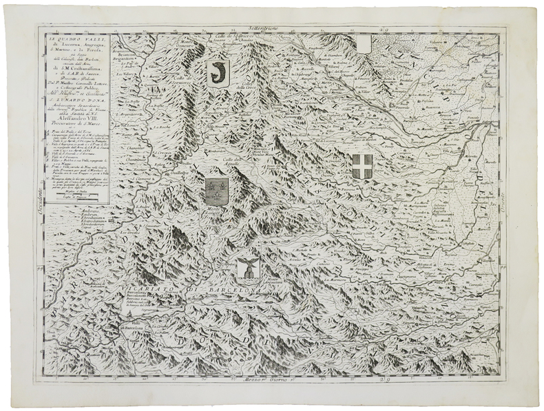
CORONELLI (Vincenzo).
Le Quattro Valli, di Lucerna, Angrogna, S. Martino, e La Perosa.
[Venise, 1690]. 448 x 596 mm.
Bookseller reference : LBW-4876
|
|
|
CORONELLI Vincenzo (Venezia 1650 - 1718)
Almanacco per l'Anno Bisestile…dalla Natività di Christo MDCLXXXVIII
Rarissimo almanacco per l'anno bisestile del 1688 di Vincenzo Maria Coronelli. L'opera è dedicata all'Abate Rezzonico, il cui ritratto è in alto a sinistra. Membro di una nota famiglia comasca, eletto governatore dello Stato Pontificio, nel 1687 assunse anche il titolo di patrizio della Serenissima. Per ogni giorno dell'anno sono ricordati gli eventi più importanti legati alla storia della Republica di Venezia.Il calendario è circondato da una bella cornice ornamentale incisa, nel tipico stile del Coronelli, dove entro delle monete sono raffigurate le piante di 24 città della Grecia, sotto il controllo di Venezia.L'opera, una separata pubblicazione, si vendeva presso la bottega dell'editore Domenico Padoani, situata a Rialto.Coronelli aveva già realizzato un calendario simile nel 1666. L'opera è assai rara e ne abbiamo riscontrato un solo esemplare conservato alla Marciana di Venezia.Incisione in rame, in ottimo stato di conservazione. Extremely rare almanac for the year 1688 by Vincenzo Maria Coronelli. The work is dedicated to Abbot Rezzonico, whose portrait is in the upper left. Member of a famous family of Como, was elected governor of the Papal States, in 1687 he also assumed the title of patrician of Venice. This almanac, for each day of the year, remember the most important events related to the history of the Republic of Venice. The calendar is surrounded by a beautiful ornamental engraved frame, in the typical style of the Coronelli, where the coins are represented by plants of 24 cities of Greece, mostly in Morea, under the control of Venice. The work, a separate publication, was published by the workshop of Domenico Padoani, in Rialto. Coronelli had already made a similar work in 1666. The almanac is very rare and we have found only one example preserved in the Marciana of Venice. Copper engraving, in excellent condition.

|
|
|
CORONELLI Vincenzo (Venezia 1650 - 1718)
Roma / intagliata e dedicata da Pietro Ridolfi nell'Accademia Cosmogra[fi]ca degli Argonauti all'eccllentissimo sig[nor]e An
- RARA PRIMA EDIZIONE -Incisa da Pietro Ridolfi per l'abate Coronelli, questa rara pianta della città viene per la prima volta pubblicata nel rarissimo Citta, Fortezze e, Isole, e Porti principali dell'Europa in Pianta et in Elevatione, Descritte, e Publicate Ad uso dell'Accademia Cosmografica degli Argonauti dal Padre Maestro Coronelli Lettore, e Cosmografo della Serenissima Republica di Venezia, edito a Venezia da Domenico Padovani nel 1689. Coronelli visse un periodo di straordinaria fecondità editoriale a partire dal 1689, quando ebbe la cattedra di geografia presso l'Università alle Procuratie, con la pubblicazione, nel 1690, del primo volume dell'Atlante Veneto. In effetti sotto il nome di Atlante Veneto va tutta la raccolta di tredici opere composte nell'arco del decennio successivo, dall'Isolario allo Specchio del mare. In realtà solo alcune di tali opere possono definirsi atlante, mentre altre, sono opere di compilazione o semplici raccolte di vedute e fortificazioni come questa rara raccolta. Contrariamente a quanto dichiarato da Marigliani, questa è la prima edizione della pianta della città, e non quella che reca la data 1698 (oltre una ricca cornice ornamentale), pubblicata in onore del Duca di Parma Francesco Farnese.Si basa, come indicato da Scaccia Scarafoni, sulla piccola pianta del Falda. Tuttavia si tratta di una derivazione arbitraria, con una raffigurazione in alzato solo di pochi edifici principali. Il grande cartiglio con il titolo, sproporzionato, contiene gli stemmi dei XIV rioni.Meraviglioso esemplare, con grandi margini, di questa rara pianta. - THE RARE FIRST STATE - Plan map, with some large buildings in bird's-eye view. Text on tablet at lower right, with coats of arms of Rome and its rioni. Oriented with east at top. Relief conveyed pictorially. Reduced copy of Falda's small plan of Rome, published 1667. See Huelsen. This example of the map is taken from the very rare Coronelli's Citta, Fortezze e, Isole, e Porti principali dell'Europa in Pianta et in Elevatione, Descritte, e Publicate Ad uso dell'Accademia Cosmografica degli Argonauti dal Padre Maestro Coronelli Lettore, e Cosmografo della Serenissima Republica di Venezia, printed in Venice by Domenico Padovani in 1689. Coronelli lived a period of extraordinary editorial fecundity starting from 1689, when he had the chair of geography at the University at the Procuratie, with the publication, in 1690, of the first volume of the Atlante Veneto. Under the name of Atlante Veneto goes the entire collection of thirteen works composed over the next decade, from the Isolario to the Specchio del mare. Copperplate, with full margins, very good condition. Very rare. Huelsen, C. Saggio di bibliografia ragionata delle piante icnografiche e prospettiche di Roma, 122; C. Marigliani, Le Piante di Roma delle collezioni private, p. 243, n. 150; Scaccia Scarafoni n. 202.

|
|
|
Corporate Author Inc Trakker Maps
Florida State Road Atlas 1999
Trakker Maps 1998-01. Paperback. Good. Trakker Maps paperback
Bookseller reference : SONG1877651931 ISBN : 1877651931 9781877651939
|
|
|
Corporate Author Mad Maps
Historic Route 66: America's Mother Road Harley-Davidson Great Roads
Mad 2007-06. Map. Good. Mad unknown
Bookseller reference : SONG1933911107 ISBN : 1933911107 9781933911106
|
|
|
Corporate Author National Geographic Maps
Las Vegas City Map & Travel Guide National Geographic Destination
National Geographic Maps 2009-01. Map. Good. National Geographic Maps unknown
Bookseller reference : SONG1597751928 ISBN : 1597751928 9781597751926

|
|
|
Corporate Author Thomas Bros. Maps
Los Angeles County Street Guide & Directory 1998: The Thomas Guide
Thomas Brothers Maps 1997-11. Paperback. Good. Thomas Brothers Maps paperback
Bookseller reference : SONG0881308749 ISBN : 0881308749 9780881308747
|
|
|
Corporate Author Thomas Brothers Maps
San Diego County Street Guide Including Imperial County 1995: Including Imperial County
Thomas Brothers Maps 1994-10. Paperback. Good. Thomas Brothers Maps paperback
Bookseller reference : SONG0881307203 ISBN : 0881307203 9780881307207
|
|
|
Corporate Author Mad Maps
Southern Cross-Country: Savannah GA to San Diego CA Harley-Davidson Great Roads
Mad Maps 2007-10. Map. Good. Mad Maps unknown
Bookseller reference : SONG1933911603 ISBN : 1933911603 9781933911601
|
|
|
Corporation of the City of Edinburgh
Edinburgh Official Guide plus City of Edinburgh Accommodation Register
Two fine unused publications in their original as-delivered well-scuffed envelope, dated 1963. No marks or inscriptions. No creasing to covers or to spines. Very clean crisp very tight booklets with bright unmarked boards and no bumping to corners. One booklet has a trace of foxing to rear. Fold-out map inside rear cover in perfect condition. 88 + 96pp.

|
|
|
CORREARD F. - SIEURIN E.
Cartes d'?tude pour servir ? l'enseignement de l'histoire : Temps modernes et contemporains (1610-1899).
Cartonn?. 14 pages. 22x29 cm. L?g?rement d?fra?chi.
|
|
|
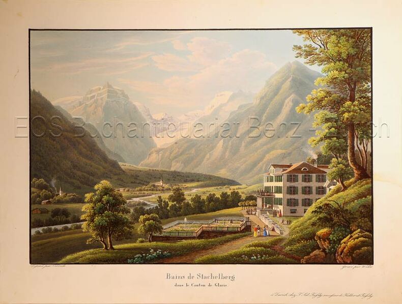
Corrodi, Salomon (1810-1892)
Bains de Stachelberg dans le Canton de Glaris.
Zürich, F. Sal Füssly successeur de Keller et Füssly, um 1835. Aquatinta von Lukas Weber (1811-1860). Bildgrösse: 17,2 x 25,2 cm. Blattgrösse: 22,4 x 29,6 cm. + Wichtig: Für unsere Kunden in der EU erfolgt der Versand alle 14 Tage verzollt ab Deutschland / Postbank-Konto in Deutschland vorhanden +, Abb.
Bookseller reference : 624DG

|
|
|
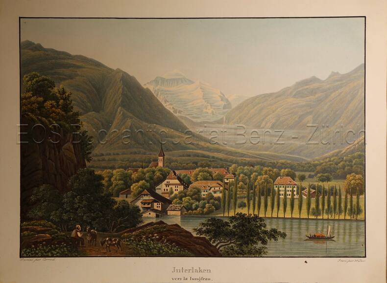
Corrodi, Salomon (1810-1892)
Interlaken vers la Jungfrau.
O.O., um 1935. Altkolorierte Aquatinta von Lukas Weber (1811-1860). Bildgrösse: 17,7 x 25,2 cm. Blattgrösse: 20,9 x 28,2 cm. + Wichtig: Für unsere Kunden in der EU erfolgt der Versand alle 14 Tage verzollt ab Deutschland / Postbank-Konto in Deutschland vorhanden +, Abb.
Bookseller reference : 617DG

|
|
|
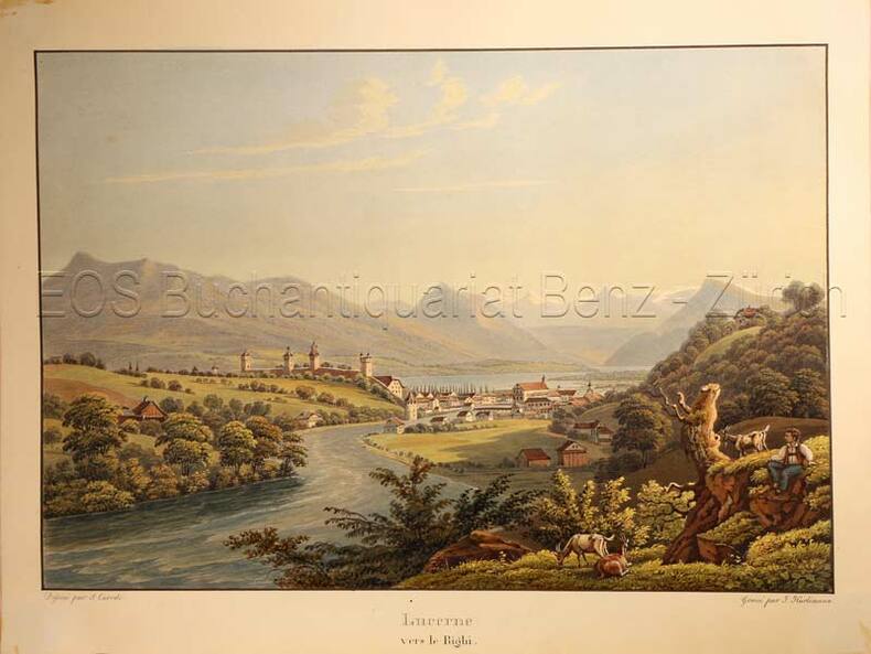
Corrodi, Salomon (1810-1892)
Lucerne vers le Righi.
O.O., um 1935. Altkolorierte Aquatinta von Johann Hürlimann (1793-1850). Bildgrösse: 16,7 x 24,7 cm. Blattgrösse: 20,5 x 27,2 cm. + Wichtig: Für unsere Kunden in der EU erfolgt der Versand alle 14 Tage verzollt ab Deutschland / Postbank-Konto in Deutschland vorhanden +, Abb.
Bookseller reference : 779CG

|
|
|
Corrodi, Salomon (1810-1892):
Bains de Stachelberg dans le Canton de Glaris.
Zürich, F. Sal Füssly successeur de Keller et Füssly, um 1835. Aquatinta von Lukas Weber (1811-1860). Bildgrösse: 17,2 x 25,2 cm. Blattgrösse: 22,4 x 29,6 cm.
Bookseller reference : 624DG
|
|
|
Corrodi, Salomon (1810-1892):
Interlaken vers la Jungfrau.
O.O., um 1935. Altkolorierte Aquatinta von Lukas Weber (1811-1860). Bildgrösse: 17,7 x 25,2 cm. Blattgrösse: 20,9 x 28,2 cm.
Bookseller reference : 617DG
|
|
|
Corrodi, Salomon (1810-1892):
Lucerne vers le Righi.
O.O., um 1935. Altkolorierte Aquatinta von Johann Hürlimann (1793-1850). Bildgrösse: 16,7 x 24,7 cm. Blattgrösse: 20,5 x 27,2 cm.
Bookseller reference : 779CG
|
|
|
CORSE...
Carte d?partementale couleurs au 1/550 000e de la Corse.
Une feuille 30x41 cm.
|
|
|
CORTÉS, Martín (1510-1582).
Breve Compendio de la Sphera y de la Arte de Navegar, con nuevos instrumentos y reglas, exemplificado con muy subtiles demonstraciones. Facsímil de la edición de Sevilla, Antón Alvarez, 1551, con estudio introductorio de Salvador García Franco y Julio F. Guillén Tato.
Zaragoza, Institución Fernando el Católico. 1945. Gran folio; 95 ff., 4 hs., 27 pp., con numerosas ilustraciones xilográficas, esquemas y planos, entre ellos una Carta del Nuevo Mundo. Edición limitada de 500 ejemplares numerados. Cubiertas originales.

|
|
|
Cosey:
Carton d'invitation - exposition Voyage en Italie, Galerie La Marge.
Lausanne, La Marge. Carton d'invitation imprimé recto-verso, au format 10,5 x 15 cm.
Bookseller reference : 12496
|
|
|
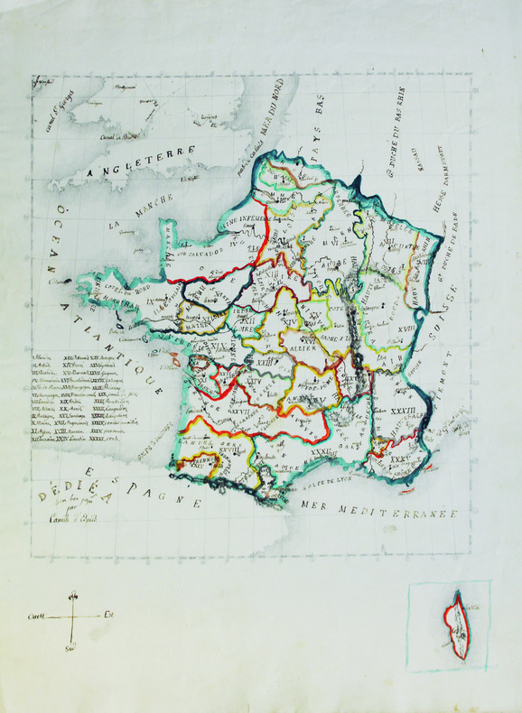
COSSART d'ESPIÈS (Louis Antoine Camille de).
[Carte de France].
[vers 1825-1830]. 52,5 x 39 cm, sur papier vélin.
Bookseller reference : LBW-6580
|
|
|
Cossdorf:
Cossdorf. "Plan der Action, welche d. 20. Febr. 1760 zwischen einem Kaserl. Königl. Ungarischen und Königl. Preussischen Corps bei Cossdorf in Sachsen vorgefallen". Schlachtenplan von Cossdorf in Sachsen, links mit Legende. Kupferstich mit farbigen Truppenaufstellungen aus "Neues Kriegs-Theater ...", 18. Supplement.
Format: 18 x 29,5 cm. *Leicht gebräunt, insgesamt gut erhalten. Landkarten de
|
|
|
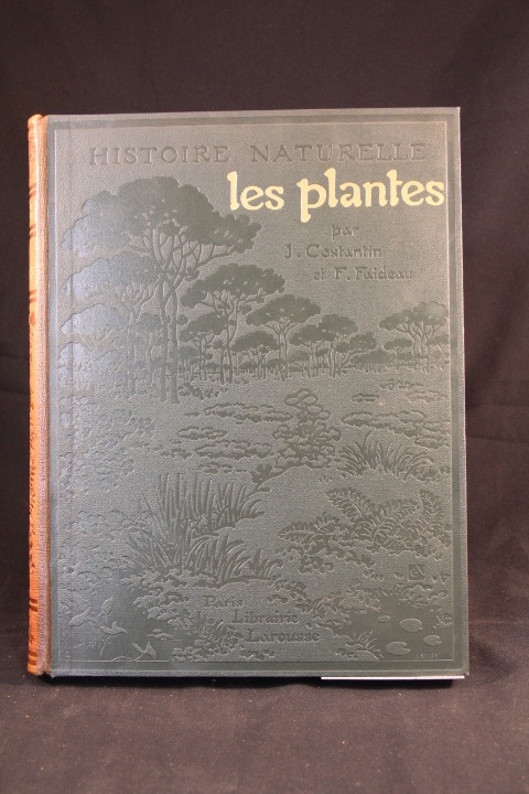
COSTANTIN J.; FAIDEAU F:
Les plantes. Histoire naturelle illustrée.
Paris, Lib. Larousse, 1922. 1 vol. in-4 de 319 p. Demi-chagrin marron, dos lisse orné, plats de percaline verte ornés à froid. Dos passé.
Bookseller reference : 2816
|
|
|
COTE D'AZUR
Carte couleurs au 1/200 000?me.
Une feuille. 98x61 cm.
|
|
|
COTES-DU-NORD
Carte grav?e (en noir) du d?partement. Extrait du Petit Atlas National. Fin XIXe.
1 feuille 24x30 cm. Rousseurs.
|
|
|
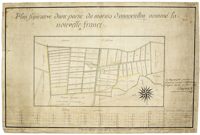
COTTIGNIES (Alexandre J.). MANUSCRIT.
Plan figurative d’une partie du marais d’Annœullin nommé la Nouvelle France.
1780. 165 x 420 mm.
Bookseller reference : LBW-527
|
|
|
Cotton, Peter Neive
Vice Regal Mansions of British Columbia
118 pages including index and black and white illustrations. A remarkable volume of archive photographs, early maps, business documents and correspondence from British Columbia's past. Letter and diary excerpts give extraordinary insights into the personalities and problems facing these key figures. Book clean, bright and unmarked with very light wear. Light wear to illustrated dust jacket. Nice copy. Book
|
|
|
Cottreau (Marcel), Le Chartier (Henri).
Indes, Extrême-Orient, Océanie. 1ere partie : de Marseille à Colombo. 2e partie. De Ceylan en Océanie.
Paris, Librairie du tourisme, (1910-1911). 2 tomes en 2 vol. in-12 X-394 pp., 3 cartes repliées volantes à l'intérieur du plat inférieur (Indes, Île de Ceylan, Planisphère) ; XXX-734 pp., 2 cartes repliées volantes à l'intérieur du plat inférieur (Australie et Tasmanie, Planisphère), percaline rouge avec titre doré sur le dos et le plat supérieur (reliure de l'éditeur).
Bookseller reference : 43078

|
|
|
COUDRAIN (Brigitte).
Carte de voeux illustrée d'une gravure originale signée.
Paris Société des peintres-graveurs français 1999 1 vol. Broché Carte de voeux dépliante sur Arches illustrée d'une belle eau-forte en couleurs (13 x 12 cm) signée par Brigitte Coudrain. En parfait état.
Bookseller reference : 109098
|
|
|
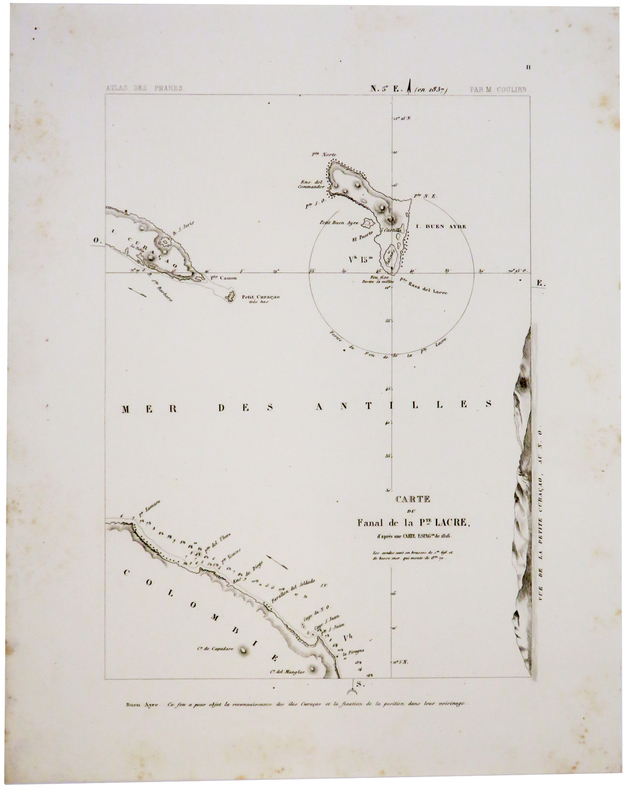
COULIER (Philippe-Jacques).
[CURACAO/BONAIRE] Carte du fanal de la Pte. Lacre d'après une carte espag.le de 1816.
Paris, [1844-1848]. 276 x 200 mm.
Bookseller reference : LBW-2415
|
|
|
COULIER (Philippe-Jacques).
[CURACAO] Plan du phare projetté de Sta Anna, de Curaçao, d'après celui de l'amirauté anglaise, de 1837.
Paris, [1844-1848]. 280 x 200 mm.
Bookseller reference : LBW-2416

|
|
|
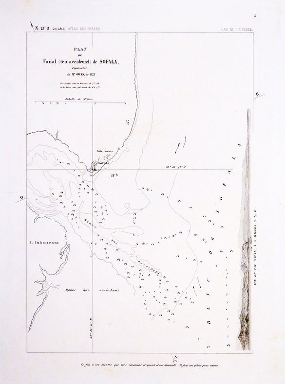
COULIER (Philippe-Jacques).
[MOZAMBIQUE] Plan du fanal (feu accidentel) de Sofala, d'après celui de M.r Owen, de 1823.
[Paris, 1844-1848]. 285 x 205 mm.
Bookseller reference : LBW-4531
|
|
|
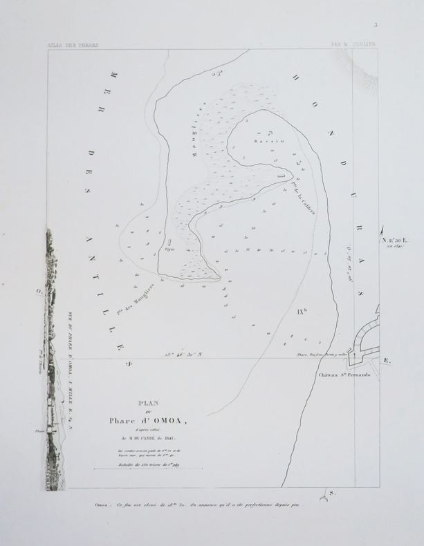
COULIER (Philippe-Jacques);
[HONDURAS] Plan du phare d'Omoa, d'après celui de M. de Candé, de 1841.
Paris 1844-1848 275 x 210 mm.
Bookseller reference : LBW-1168
|
|
|
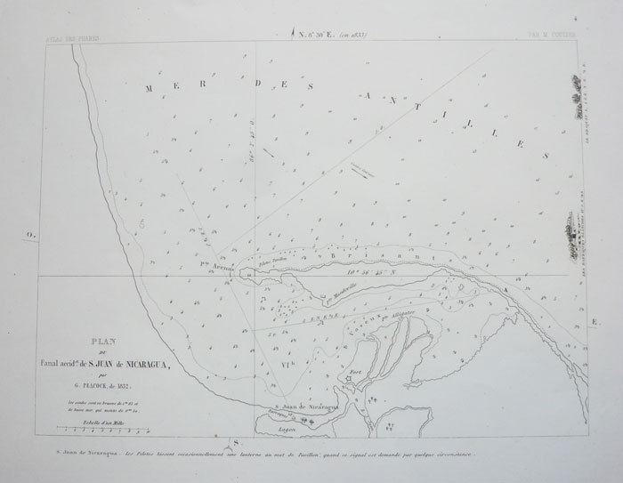
COULIER (Philippe-Jacques);
[NICARAGUA] Plan du fanal accid.el de S. Juan de Nicaragua, par G. Peacock, de 1832.
Paris 1844-1848 205 x 275 mm.
Bookseller reference : LBW-1169
|
|
|
County Maps
BELL COUNTY TEXAS General Highway Map
Austin: State Dept. Of Highways 1989. 18" x 24.5" black & white map of Bell County. 1st. Fine. State Dept. Of Highways unknown
Bookseller reference : 015526
|
|
|
County Maps
CORYELL COUNTY TEXAS General Highway Map
Austin: State Dept. Of Highways 1981. 18" x 24.5" map of Coryell County in color. 1st. Fine. State Dept. Of Highways unknown
Bookseller reference : 015525
|
|
|
County Maps
FALLS COUNTY TEXAS General Highway Map
Austin: State Dept. Of Highways 1989. 18" x 25" black & white map of Falls County. 1st. Fine. State Dept. Of Highways unknown
Bookseller reference : 015533
|
|
|
County Maps
HILL COUNTY TEXAS General Highway Map
Austin: State Dept. Of Highways 1986. 18" x 25" black & white map of Hill County. 1st. Fine. State Dept. Of Highways unknown
Bookseller reference : 015521
|
|
|
County Maps
HILL COUNTY TEXAS General Highway Map
Austin: State Dept. Of Highways 1989. 18" x 25" black & white map of Hill County. 1st. Fine. State Dept. Of Highways unknown
Bookseller reference : 015532
|
|
|
County Maps
LIMESTONE COUNTY TEXAS General Highway Map
Austin: State Dept. Of Highways 1989. 18" x 24.5" black & white map of Limestone County. 1st. Near Fine. State Dept. Of Highways unknown
Bookseller reference : 015531
|
|
|
County Maps
McLENNAN COUNTY TEXAS General Highway Map
Austin: State Dept. Of Highways 1986. 18" x 24.5" black & white map of McLennan County. 1st. Fine. State Dept. Of Highways unknown
Bookseller reference : 015524
|
|
|
County Maps
SOMERVELL COUNTY TEXAS General Highway Map
Austin: State Dept. Of Highways 1976. 18" x 24.5" black & white map of Somervell County. 1st. Fine. State Dept. Of Highways unknown
Bookseller reference : 015522
|
|
|
County Maps
TEXAS QUADRANT MAP Featuring JOHNSON & HILL COUNTIES with McLENNAN & BOSQUE COUNTIES
Arlington: D & L MAP SERVICE 1986. 23" x 35" two sided map of four Texas counties. Very Good. D & L MAP SERVICE unknown
Bookseller reference : 015530
|
|
|
County Maps
WILLIAMSON COUNTY TEXAS General Highway Map
Austin: State Dept. Of Highways 1988. Two 18" x 24.5" black & white sheets showing map of Williamson County. 1st. Fine. State Dept. Of Highways unknown
Bookseller reference : 015527
|
|
|
Coupland, Douglas
Souvenir of Canada
book in as new condition. Soft covers with self-wraps. 143pp. An introduction to Canada, very well illustrated.

|
|
|
COURSIER A.
Lille et ses environs autrefois.
Horvath, 1982, un volume in 8 broché, 208 pages, très nombreuses reproductions de cartes postales anciennes. Petite annotation sur la page de titre, il semble qu'il manque une page de garde, page vierge. sinon bon état.
Bookseller reference : 5907
|
|
|
COURSIER, Alain.
Le Nord autrefois. Valenciennois - Avesnois - Cambrésis - Douaisis.
Editions Horvath, 1985 ; grand in-8°, broché, couverture rouge illustrée d'une carte postale en noir et blanc, titre en blanc au 1er plat, titre en noir et ocre au dos; 183pp. illustré de très nombreuses cartes postales et photographies anciennes.
Bookseller reference : c6343
|
|
 Receive by email
 Download as PDF document
 RSS feed


