|
|
|
Mad Maps Firm
Get Outta Town Houston
Mad Maps Firm 2006-11-07. 2006. Map. Used:Good. Mad Maps (Firm) unknown
Referencia librero : DADAX1933911042 ISBN : 1933911042 9781933911045

|
|
|
Mad Maps Firm
Get Outta Town Memphis
Mad Maps Firm 2007-02-15. 2007. Map. Used:Good. Mad Maps (Firm) unknown
Referencia librero : DADAX1933911301 ISBN : 1933911301 9781933911304

|
|
|
Mad Maps Firm
Get Outta Town Columbus
Mad Maps Firm 2007-02-15. 2007. Map. Used:Good. Mad Maps (Firm) unknown
Referencia librero : DADAX193391128X ISBN : 193391128X 9781933911281

|
|
|
Mad Maps Firm
Get Outta Town Detroit
Mad Maps Firm 2007-02-15. 2007. Map. Used:Good. Mad Maps (Firm) unknown
Referencia librero : DADAX1933911255 ISBN : 1933911255 9781933911250

|
|
|
Mad Maps Firm
Get Outta Town Phoenix
Mad Maps Firm 2006-12-01. 2006. Map. Used:Good. Mad Maps (Firm) unknown
Referencia librero : DADAX1933911166 ISBN : 1933911166 9781933911168
|
|
|
Mad Maps Firm
Get Outta Town San Diego
Mad Maps Firm 2006-12-01. 2007. Map. Used:Good. Mad Maps (Firm) unknown
Referencia librero : DADAX1933911115 ISBN : 1933911115 9781933911113
|
|
|
Mad Maps Firm
Get Outta Town Chicago
Mad Maps Firm 2007-02-15. 2007. Map. Used:Good. Mad Maps (Firm) unknown
Referencia librero : DADAX1933911263 ISBN : 1933911263 9781933911267
|
|
|
Mad Maps Firm
Louisiana and Mississippi Regional Scenic Tours Mad Maps
Mad Maps Firm 2007-10-01. 2008. Map. Good. Mad Maps (Firm) unknown
Referencia librero : SONG1933911492 ISBN : 1933911492 9781933911496
|
|
|
Mad Maps Firm
Scenic Road Trips of Minnasota & Iowa 27 Great Drives!
Mad Maps Firm 2007-10-01. 2009. Map. Good. Mad Maps (Firm) unknown
Referencia librero : SONG1933911530 ISBN : 1933911530 9781933911533
|
|
|
Mad Maps Firm
Scenic Road Trips of Arizona & Utah 32 Great Drives!
Mad Maps Firm 2007-10-01. 2010. Map. Good. Mad Maps (Firm) unknown
Referencia librero : SONG1933911468 ISBN : 1933911468 9781933911465
|
|
|
Mad Maps Firm
Scenic Road Trips of Texas 26 Great Drives U.S. Regional Touring Map: Gulf States: Part 2
Mad Maps Firm 2007-02-15. 2010. Map. Good. Mad Maps (Firm) unknown
Referencia librero : SONG1933911360 ISBN : 1933911360 9781933911366
|
|
|
Mad Maps Firm
U.S. Regional Touring Map: Gulf States: Part 4
Mad Maps Firm 2007-10-01. 2008. Map. Good. Mad Maps (Firm) unknown
Referencia librero : SONG1933911506 ISBN : 1933911506 9781933911502
|
|
|
Mad Maps Firm
U.S. Regional Touring Map: Central States: Part 3
Mad Maps Firm 2007-10-01. 2009. Map. Good. Mad Maps (Firm) unknown
Referencia librero : SONG1933911522 ISBN : 1933911522 9781933911526
|
|
|
Mad Maps Firm
U.S. Regional Touring Map: Central States: Part 4
Mad Maps Firm 2007-10-01. 2009. Map. Good. Mad Maps (Firm) unknown
Referencia librero : SONG1933911514 ISBN : 1933911514 9781933911519
|
|
|
MAD Maps; MAD MAPS Editor; MAD MAPS Illustrator;
MAD Maps - Scenic Road Trips Map of Virginia - East West Virginia - Maryland - Delaware - USRT190
MAD Maps 2013-07-01. Map. Used:Good. MAD Maps unknown
Referencia librero : DADAX193391193X ISBN : 193391193X 9781933911939
|
|
|
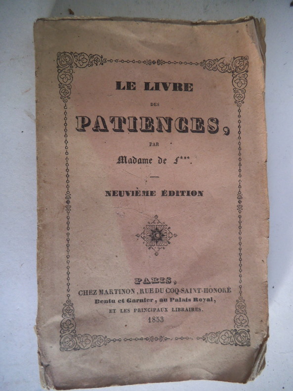
MADAME De F
Le Livre Des Patiences
Paris Dentu & Garnier 1894 In12 Exemplaire a restaurer ou relier - 108 pages - manques important sur le 1er plat - dos cassé
Referencia librero : 25Et
|
|
|
MADAME De F
Le Livre Des Patiences
Paris Dentu & Garnier 1894 In12 Exemplaire a restaurer ou relier - 108 pages - manques important sur le 1er plat - dos cassé
Referencia librero : 25Et
|
|
|
Madame de F…
Le livre des patiences.
In 16 broché, faux-titre, titre, 106 pages, Paris chez Martinon 1852. (Ccouverture datée 1853) La loi salique-le moulin-les quatorze- la brocarde-la carte voyageuse- le sultan- la duchesse de Luynes- etc.
Referencia librero : 12402
|
|
|
Mader, Richard
Leipzig. Kultur- und Messestadt
Book appears in mint unread condition. Fold-out map at rar in perfect condition. 96pp. Guide to the cultural, music and trade fair city in Saxony, Germany. Well illustrated. All text in German.

|
|
|
MAESTRACCI Noël (Commandant) Nombreuses photographies dans le texte, nombreuses cartes.
L'Empire colonial français contemporain. Historique. Ressources. Avenir. Renseignements pratiques. 1re édition. Par le Commandant Noël Maestracci, de l'infanterie coloniale.
Couverture souple. Broché. 367 pages.
Referencia librero : 144573

|
|
|
MAGENTHAL
Carte allemande au 1/80 000?. Fin XIXe.
1 feuille repli?e. 31,5x45 cm.
|
|
|
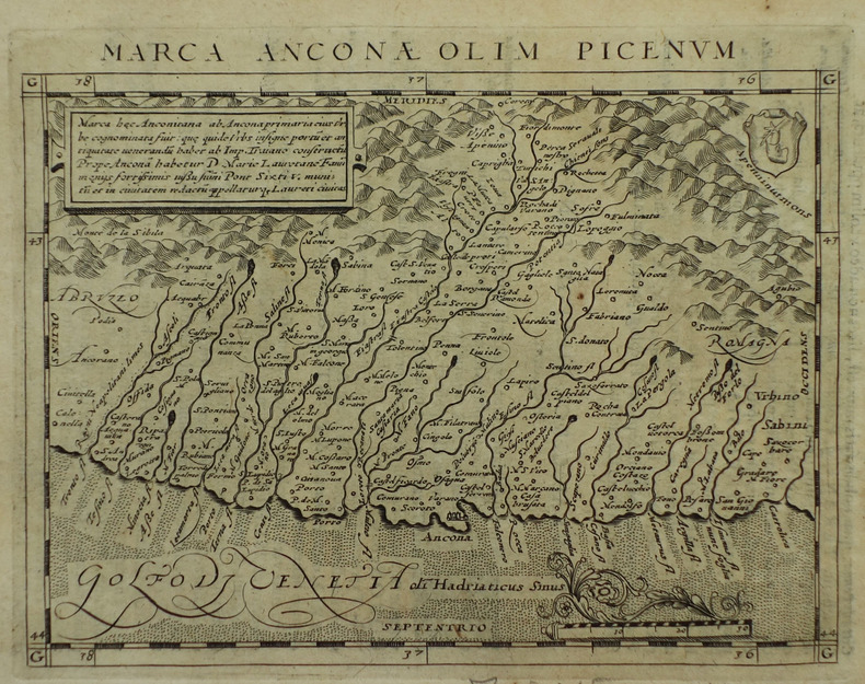
MAGINI (Giovanni Antonio) & PTOLEMEE (Claude).
[ANCONE] Marca Anconae olim Picenum.
[Arnhem, Joannes Jansson, 1617]. 130 x 168 mm.
Referencia librero : LBW-1926
|
|
|
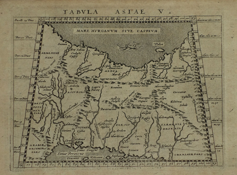
MAGINI (Giovanni Antonio) & PTOLEMEE (Claude).
[IRAN/AFGHANISTAN/PAKISTAN] Tabula Asiae V.
[Arnhem, Joannes Jansson, 1617]. 128 x 170 mm.
Referencia librero : LBW-1923
|
|
|
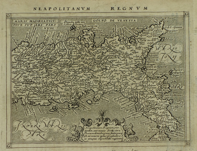
MAGINI (Giovanni Antonio) & PTOLEMEE (Claude).
[NAPLES] Neapolitanum regnum.
[Arnhem, Joannes Jansson, 1617]. 128 x 168 mm.
Referencia librero : LBW-1938
|
|
|
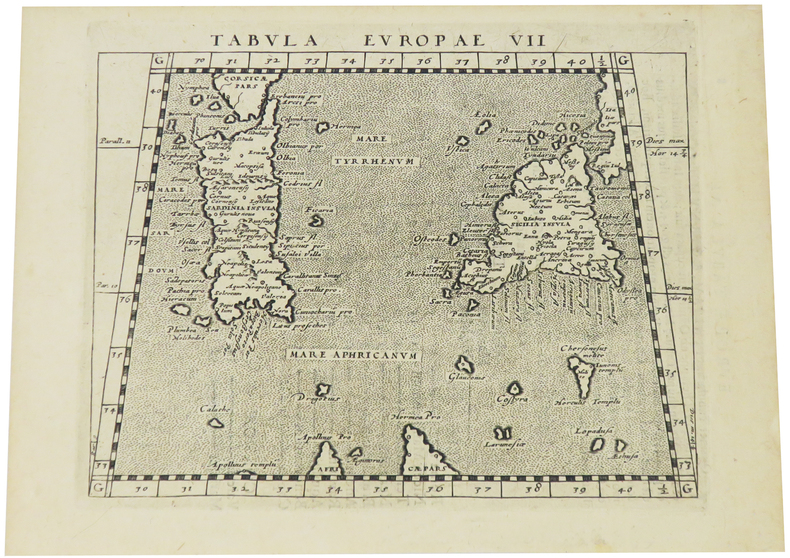
MAGINI (Giovanni Antonio) & PTOLEMEE (Claude).
[SARDAIGNE & SICILE] Tabula Europae VII.
[Arnhem, Joannes Jansson, 1617]. 130 x 168 mm.
Referencia librero : LBW-1918
|
|
|
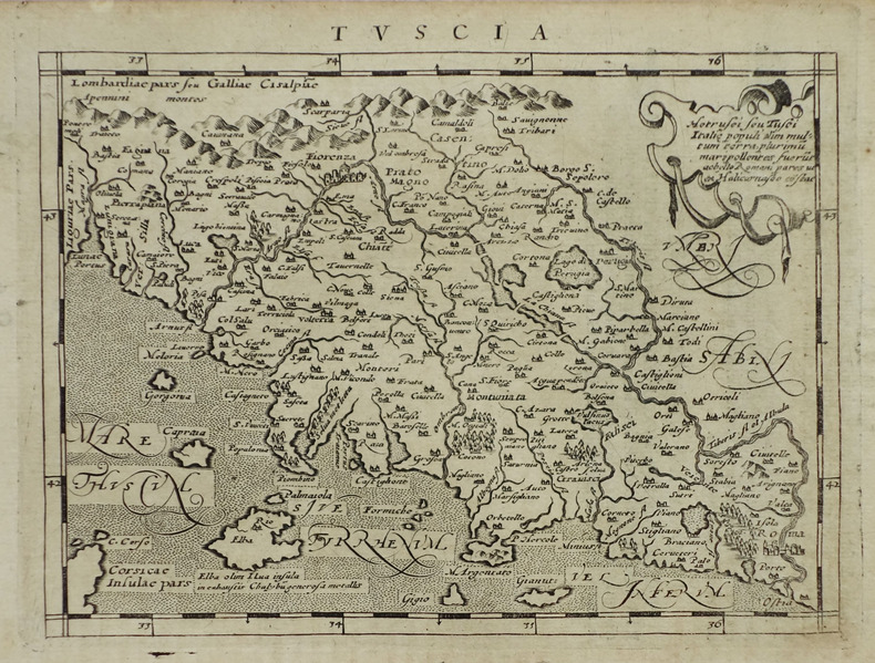
MAGINI (Giovanni Antonio) & PTOLEMEE (Claude).
[TOSCANE] Tuscia.
[Arnhem, Joannes Jansson, 1617]. 130 x 169 mm.
Referencia librero : LBW-1934
|
|
|
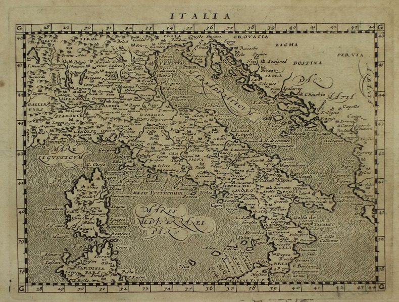
MAGINI (Giovanni Antonio) & PTOLEMEE (Claude).
Italia.
[Arnhem, Joannes Jansson, 1617]. 129 x 170 mm.
Referencia librero : LBW-1933
|
|
|
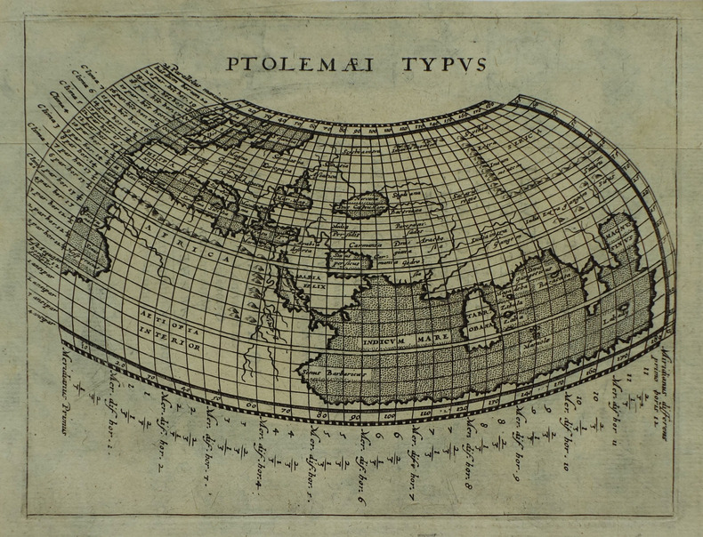
MAGINI (Giovanni Antonio) & PTOLEMEE (Claude).
Ptolemaei typus.
[Arnhem, Joannes Jansson, 1617]. 132 x 172 mm.
Referencia librero : LBW-1937
|
|
|
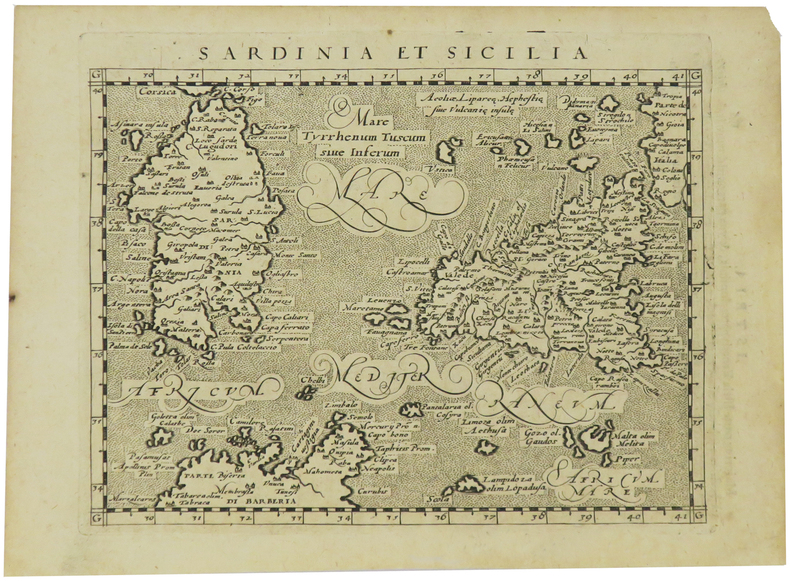
MAGINI (Giovanni Antonio) & PTOLEMEE (Claude).
Sardinia et Sicilia.
[Arnhem, Joannes Jansson, 1617]. 130 x 169 mm.
Referencia librero : LBW-1935
|
|
|
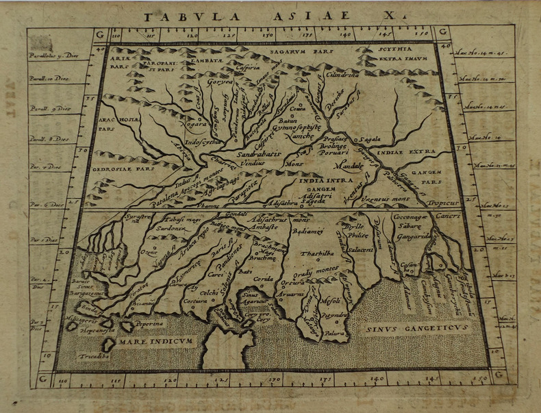
MAGINI (Giovanni Antonio) & PTOLEMEE (Claude).
Tabula Asiae X.
[Arnhem, Joannes Jansson, 1617]. 129 x 167 mm.
Referencia librero : LBW-1932
|
|
|
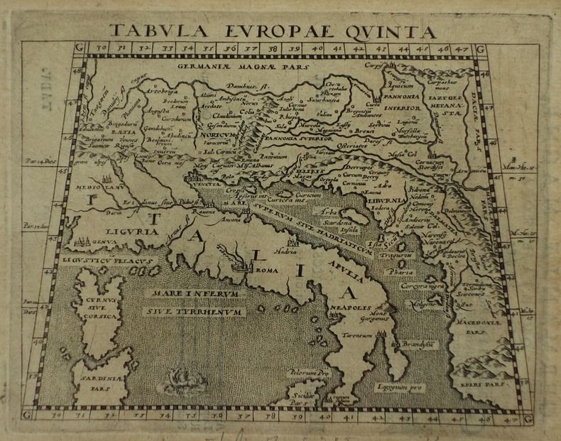
MAGINI (Giovanni Antonio) & PTOLEMEE (Claude).
Tabula Europae quinta.
[Arnhem, Joannes Jansson, 1617]. 127 x 163 mm.
Referencia librero : LBW-1931
|
|
|
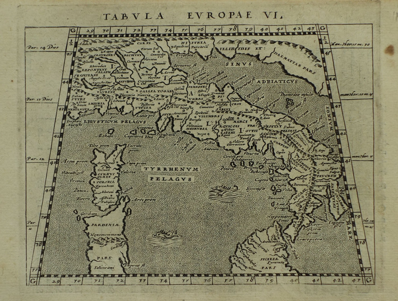
MAGINI (Giovanni Antonio) & PTOLEMEE (Claude).
Tabula Europae VI.
[Arnhem, Joannes Jansson, 1617]. 130 x 166 mm.
Referencia librero : LBW-1921
|
|
|
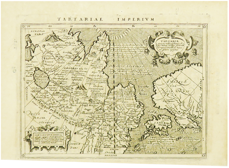
MAGINI (Giovanni Antonio) & PTOLEMEE (Claude).
Tartariae imperium.
[Arnhem, Joannes Jansson, 1617]. 129 x 170 mm.
Referencia librero : LBW-1964
|
|
|
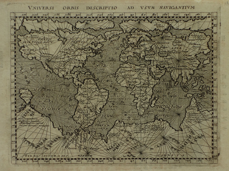
MAGINI (Giovanni Antonio) & PTOLEMEE (Claude).
Universi orbis descriptio ad usum navigantium.
[Arnhem, Joannes Jansson, 1617]. 131 x 172 mm.
Referencia librero : LBW-1922
|
|
|
MAGNAGHI, Alberto
La carta nautica costruita nel 1325 da Angelino Dalorto
In -4°, pp. 15 più una grande carta più volte ripiegata. E’ la riproduzione fotozincografica della carta di Dalorto, che rappresentava con notevole dettaglio per l’epoca la costa del Nord Europa. It’s the photozincographic reprodution of Dalorto’s Map, detailing the Northern European Coast.
|
|
|
MAGNAN Dominique (29 maggio 1731, Reillanne, Francia - agosto 1796, Firenze)
Arenula seu Regula Regio VII
Pianta del rione tratta dalla celebre guida di Roma di Dominique Magnan La ville de Rome, ou, Description abrégée de cette superbe ville: divisée en quatre volumes: et ornée de 425 planches en taille douce. A Rome: De l'imprimerie d'Archange Casaletti ... : Chez Venan. Monaldini, Bouchard et Gravier : Gregoire Settari ..., 1778. Dominique Magnan (1731–1796), dotto abate francese del convento della Trinità dei Monti, dell'ordine dei minimi, a Roma, che fu profondamente coinvolto nella vita intellettuale della sua comunità durante la seconda metà del XVIII secolo. Ha studiato all'università di Avignone, poi si è unito ai Minimi di La Ciotat all'età di 20 anni, dove ha iniziato la sua carriera come collezionista di monete e medaglie antiche. Nominato professore di teologia a Marsiglia, ha continuato il suo lavoro. Si mise in contatto con i più famosi antiquari dell'epoca, sia in Italia che in Germania, e acquisì rapidamente una vasta reputazione. I suoi primi libri hanno ricevuto il plauso della critica. Ma i suoi lavori più significativi erano sulla numismatica sebbene fortemente criticati dagli specialisti dell'epoca in quanto la copertura universale e completa del soggetto poteva mantenere la confusione tra monete autentiche e false. Bibliografia: Rossetti, G-1285; Schudt 363. Map taken from the famous guide of Rome by Dominique Magnan La ville de Rome, ou, Description abrégée de cette superbe ville: divisée en quatre volumes: et ornée de 425 planches en taille douce. A Rome: De l'imprimerie d'Archange Casaletti ... : Chez Venan. Monaldini, Bouchard et Gravier : Gregoire Settari ..., 1778. Dominique Magnan (1731–1796), a learned French abbot of the Trinità dei Monti convent, of the order of the minims, in Rome, who was deeply involved in the intellectual life of his community during the second half of the 18th century. He studied at the University of Avignon, then joined the Minims of La Ciotat at age 20, where he began his career as a collector of ancient coins and medals. Appointed professor of theology in Marseille, he continued his work. He got in touch with the most famous antiquaries of the time, both in Italy and Germany, and speedily acquired an extensive reputation. His first books received critical acclaim. But his most significant works were on numismatics though heavily criticized by specialists of the time in that universal and complete coverage of the subject could maintain confusion between authentic coins and the fake ones. Bibliografia: Rossetti, G-1285; Schudt 363.

|
|
|
MAGNAN Dominique (29 maggio 1731, Reillanne, Francia - agosto 1796, Firenze)
Campi Martii Regio IV Romana qualis erat anno 1777
Pianta del rione tratta dalla celebre guida di Roma di Dominique Magnan La ville de Rome, ou, Description abrégée de cette superbe ville: divisée en quatre volumes: et ornée de 425 planches en taille douce. A Rome: De l'imprimerie d'Archange Casaletti ... : Chez Venan. Monaldini, Bouchard et Gravier : Gregoire Settari ..., 1778. Dominique Magnan (1731–1796), dotto abate francese del convento della Trinità dei Monti, dell'ordine dei minimi, a Roma, che fu profondamente coinvolto nella vita intellettuale della sua comunità durante la seconda metà del XVIII secolo. Ha studiato all'università di Avignone, poi si è unito ai Minimi di La Ciotat all'età di 20 anni, dove ha iniziato la sua carriera come collezionista di monete e medaglie antiche. Nominato professore di teologia a Marsiglia, ha continuato il suo lavoro. Si mise in contatto con i più famosi antiquari dell'epoca, sia in Italia che in Germania, e acquisì rapidamente una vasta reputazione. I suoi primi libri hanno ricevuto il plauso della critica. Ma i suoi lavori più significativi erano sulla numismatica sebbene fortemente criticati dagli specialisti dell'epoca in quanto la copertura universale e completa del soggetto poteva mantenere la confusione tra monete autentiche e false. Bibliografia: Rossetti, G-1285; Schudt 363. Map taken from the famous guide of Rome by Dominique Magnan La ville de Rome, ou, Description abrégée de cette superbe ville: divisée en quatre volumes: et ornée de 425 planches en taille douce. A Rome: De l'imprimerie d'Archange Casaletti ... : Chez Venan. Monaldini, Bouchard et Gravier : Gregoire Settari ..., 1778. Dominique Magnan (1731–1796), a learned French abbot of the Trinità dei Monti convent, of the order of the minims, in Rome, who was deeply involved in the intellectual life of his community during the second half of the 18th century. He studied at the University of Avignon, then joined the Minims of La Ciotat at age 20, where he began his career as a collector of ancient coins and medals. Appointed professor of theology in Marseille, he continued his work. He got in touch with the most famous antiquaries of the time, both in Italy and Germany, and speedily acquired an extensive reputation. His first books received critical acclaim. But his most significant works were on numismatics though heavily criticized by specialists of the time in that universal and complete coverage of the subject could maintain confusion between authentic coins and the fake ones. Bibliografia: Rossetti, G-1285; Schudt 363.

|
|
|
MAGNAN Dominique (29 maggio 1731, Reillanne, Francia - agosto 1796, Firenze)
Columnae Regio III Romana qualis erat anno 1777
Pianta del rione tratta dalla celebre guida di Roma di Dominique Magnan La ville de Rome, ou, Description abrégée de cette superbe ville: divisée en quatre volumes: et ornée de 425 planches en taille douce. A Rome: De l'imprimerie d'Archange Casaletti ... : Chez Venan. Monaldini, Bouchard et Gravier : Gregoire Settari ..., 1778. Dominique Magnan (1731–1796), dotto abate francese del convento della Trinità dei Monti, dell'ordine dei minimi, a Roma, che fu profondamente coinvolto nella vita intellettuale della sua comunità durante la seconda metà del XVIII secolo. Ha studiato all'università di Avignone, poi si è unito ai Minimi di La Ciotat all'età di 20 anni, dove ha iniziato la sua carriera come collezionista di monete e medaglie antiche. Nominato professore di teologia a Marsiglia, ha continuato il suo lavoro. Si mise in contatto con i più famosi antiquari dell'epoca, sia in Italia che in Germania, e acquisì rapidamente una vasta reputazione. I suoi primi libri hanno ricevuto il plauso della critica. Ma i suoi lavori più significativi erano sulla numismatica sebbene fortemente criticati dagli specialisti dell'epoca in quanto la copertura universale e completa del soggetto poteva mantenere la confusione tra monete autentiche e false. Bibliografia: Rossetti, G-1285; Schudt 363. Map taken from the famous guide of Rome by Dominique Magnan La ville de Rome, ou, Description abrégée de cette superbe ville: divisée en quatre volumes: et ornée de 425 planches en taille douce. A Rome: De l'imprimerie d'Archange Casaletti ... : Chez Venan. Monaldini, Bouchard et Gravier : Gregoire Settari ..., 1778. Dominique Magnan (1731–1796), a learned French abbot of the Trinità dei Monti convent, of the order of the minims, in Rome, who was deeply involved in the intellectual life of his community during the second half of the 18th century. He studied at the University of Avignon, then joined the Minims of La Ciotat at age 20, where he began his career as a collector of ancient coins and medals. Appointed professor of theology in Marseille, he continued his work. He got in touch with the most famous antiquaries of the time, both in Italy and Germany, and speedily acquired an extensive reputation. His first books received critical acclaim. But his most significant works were on numismatics though heavily criticized by specialists of the time in that universal and complete coverage of the subject could maintain confusion between authentic coins and the fake ones. Bibliografia: Rossetti, G-1285; Schudt 363.

|
|
|
MAGNAN Dominique (29 maggio 1731, Reillanne, Francia - agosto 1796, Firenze)
Montes Regio I. Romana qualis erat anno 1777
Pianta del rione tratta dalla celebre guida di Roma di Dominique Magnan La ville de Rome, ou, Description abrégée de cette superbe ville: divisée en quatre volumes: et ornée de 425 planches en taille douce. A Rome: De l'imprimerie d'Archange Casaletti ... : Chez Venan. Monaldini, Bouchard et Gravier : Gregoire Settari ..., 1778. Dominique Magnan (1731–1796), dotto abate francese del convento della Trinità dei Monti, dell'ordine dei minimi, a Roma, che fu profondamente coinvolto nella vita intellettuale della sua comunità durante la seconda metà del XVIII secolo. Ha studiato all'università di Avignone, poi si è unito ai Minimi di La Ciotat all'età di 20 anni, dove ha iniziato la sua carriera come collezionista di monete e medaglie antiche. Nominato professore di teologia a Marsiglia, ha continuato il suo lavoro. Si mise in contatto con i più famosi antiquari dell'epoca, sia in Italia che in Germania, e acquisì rapidamente una vasta reputazione. I suoi primi libri hanno ricevuto il plauso della critica. Ma i suoi lavori più significativi erano sulla numismatica sebbene fortemente criticati dagli specialisti dell'epoca in quanto la copertura universale e completa del soggetto poteva mantenere la confusione tra monete autentiche e false. Bibliografia: Rossetti, G-1285; Schudt 363. Map taken from the famous guide of Rome by Dominique Magnan La ville de Rome, ou, Description abrégée de cette superbe ville: divisée en quatre volumes: et ornée de 425 planches en taille douce. A Rome: De l'imprimerie d'Archange Casaletti ... : Chez Venan. Monaldini, Bouchard et Gravier : Gregoire Settari ..., 1778. Dominique Magnan (1731–1796), a learned French abbot of the Trinità dei Monti convent, of the order of the minims, in Rome, who was deeply involved in the intellectual life of his community during the second half of the 18th century. He studied at the University of Avignon, then joined the Minims of La Ciotat at age 20, where he began his career as a collector of ancient coins and medals. Appointed professor of theology in Marseille, he continued his work. He got in touch with the most famous antiquaries of the time, both in Italy and Germany, and speedily acquired an extensive reputation. His first books received critical acclaim. But his most significant works were on numismatics though heavily criticized by specialists of the time in that universal and complete coverage of the subject could maintain confusion between authentic coins and the fake ones. Bibliografia: Rossetti, G-1285; Schudt 363.

|
|
|
MAGNAN Dominique (29 maggio 1731, Reillanne, Francia - agosto 1796, Firenze)
Parionis Regio VI. Romana qualis erat anno 1777
Pianta del rione tratta dalla celebre guida di Roma di Dominique Magnan La ville de Rome, ou, Description abrégée de cette superbe ville: divisée en quatre volumes: et ornée de 425 planches en taille douce. A Rome: De l'imprimerie d'Archange Casaletti ... : Chez Venan. Monaldini, Bouchard et Gravier : Gregoire Settari ..., 1778. Dominique Magnan (1731–1796), dotto abate francese del convento della Trinità dei Monti, dell'ordine dei minimi, a Roma, che fu profondamente coinvolto nella vita intellettuale della sua comunità durante la seconda metà del XVIII secolo. Ha studiato all'università di Avignone, poi si è unito ai Minimi di La Ciotat all'età di 20 anni, dove ha iniziato la sua carriera come collezionista di monete e medaglie antiche. Nominato professore di teologia a Marsiglia, ha continuato il suo lavoro. Si mise in contatto con i più famosi antiquari dell'epoca, sia in Italia che in Germania, e acquisì rapidamente una vasta reputazione. I suoi primi libri hanno ricevuto il plauso della critica. Ma i suoi lavori più significativi erano sulla numismatica sebbene fortemente criticati dagli specialisti dell'epoca in quanto la copertura universale e completa del soggetto poteva mantenere la confusione tra monete autentiche e false. Bibliografia: Rossetti, G-1285; Schudt 363. Map taken from the famous guide of Rome by Dominique Magnan La ville de Rome, ou, Description abrégée de cette superbe ville: divisée en quatre volumes: et ornée de 425 planches en taille douce. A Rome: De l'imprimerie d'Archange Casaletti ... : Chez Venan. Monaldini, Bouchard et Gravier : Gregoire Settari ..., 1778. Dominique Magnan (1731–1796), a learned French abbot of the Trinità dei Monti convent, of the order of the minims, in Rome, who was deeply involved in the intellectual life of his community during the second half of the 18th century. He studied at the University of Avignon, then joined the Minims of La Ciotat at age 20, where he began his career as a collector of ancient coins and medals. Appointed professor of theology in Marseille, he continued his work. He got in touch with the most famous antiquaries of the time, both in Italy and Germany, and speedily acquired an extensive reputation. His first books received critical acclaim. But his most significant works were on numismatics though heavily criticized by specialists of the time in that universal and complete coverage of the subject could maintain confusion between authentic coins and the fake ones. Bibliografia: Rossetti, G-1285; Schudt 363.

|
|
|
MAGNAN Dominique (29 maggio 1731, Reillanne, Francia - agosto 1796, Firenze)
Pinea Regio IX Romana qualis erat anno 1777
Pianta del rione tratta dalla celebre guida di Roma di Dominique Magnan La ville de Rome, ou, Description abrégée de cette superbe ville: divisée en quatre volumes: et ornée de 425 planches en taille douce. A Rome: De l'imprimerie d'Archange Casaletti ... : Chez Venan. Monaldini, Bouchard et Gravier : Gregoire Settari ..., 1778. Dominique Magnan (1731–1796), dotto abate francese del convento della Trinità dei Monti, dell'ordine dei minimi, a Roma, che fu profondamente coinvolto nella vita intellettuale della sua comunità durante la seconda metà del XVIII secolo. Ha studiato all'università di Avignone, poi si è unito ai Minimi di La Ciotat all'età di 20 anni, dove ha iniziato la sua carriera come collezionista di monete e medaglie antiche. Nominato professore di teologia a Marsiglia, ha continuato il suo lavoro. Si mise in contatto con i più famosi antiquari dell'epoca, sia in Italia che in Germania, e acquisì rapidamente una vasta reputazione. I suoi primi libri hanno ricevuto il plauso della critica. Ma i suoi lavori più significativi erano sulla numismatica sebbene fortemente criticati dagli specialisti dell'epoca in quanto la copertura universale e completa del soggetto poteva mantenere la confusione tra monete autentiche e false. Bibliografia: Rossetti, G-1285; Schudt 363. Map taken from the famous guide of Rome by Dominique Magnan La ville de Rome, ou, Description abrégée de cette superbe ville: divisée en quatre volumes: et ornée de 425 planches en taille douce. A Rome: De l'imprimerie d'Archange Casaletti ... : Chez Venan. Monaldini, Bouchard et Gravier : Gregoire Settari ..., 1778. Dominique Magnan (1731–1796), a learned French abbot of the Trinità dei Monti convent, of the order of the minims, in Rome, who was deeply involved in the intellectual life of his community during the second half of the 18th century. He studied at the University of Avignon, then joined the Minims of La Ciotat at age 20, where he began his career as a collector of ancient coins and medals. Appointed professor of theology in Marseille, he continued his work. He got in touch with the most famous antiquaries of the time, both in Italy and Germany, and speedily acquired an extensive reputation. His first books received critical acclaim. But his most significant works were on numismatics though heavily criticized by specialists of the time in that universal and complete coverage of the subject could maintain confusion between authentic coins and the fake ones. Bibliografia: Rossetti, G-1285; Schudt 363.

|
|
|
MAGNAN Dominique (29 maggio 1731, Reillanne, Francia - agosto 1796, Firenze)
Ripae Regio XIII. Romana qualis erat anno 1777
Pianta del rione tratta dalla celebre guida di Roma di Dominique Magnan La ville de Rome, ou, Description abrégée de cette superbe ville: divisée en quatre volumes: et ornée de 425 planches en taille douce. A Rome: De l'imprimerie d'Archange Casaletti ... : Chez Venan. Monaldini, Bouchard et Gravier : Gregoire Settari ..., 1778. Dominique Magnan (1731–1796), dotto abate francese del convento della Trinità dei Monti, dell'ordine dei minimi, a Roma, che fu profondamente coinvolto nella vita intellettuale della sua comunità durante la seconda metà del XVIII secolo. Ha studiato all'università di Avignone, poi si è unito ai Minimi di La Ciotat all'età di 20 anni, dove ha iniziato la sua carriera come collezionista di monete e medaglie antiche. Nominato professore di teologia a Marsiglia, ha continuato il suo lavoro. Si mise in contatto con i più famosi antiquari dell'epoca, sia in Italia che in Germania, e acquisì rapidamente una vasta reputazione. I suoi primi libri hanno ricevuto il plauso della critica. Ma i suoi lavori più significativi erano sulla numismatica sebbene fortemente criticati dagli specialisti dell'epoca in quanto la copertura universale e completa del soggetto poteva mantenere la confusione tra monete autentiche e false. Bibliografia: Rossetti, G-1285; Schudt 363. Map taken from the famous guide of Rome by Dominique Magnan La ville de Rome, ou, Description abrégée de cette superbe ville: divisée en quatre volumes: et ornée de 425 planches en taille douce. A Rome: De l'imprimerie d'Archange Casaletti ... : Chez Venan. Monaldini, Bouchard et Gravier : Gregoire Settari ..., 1778. Dominique Magnan (1731–1796), a learned French abbot of the Trinità dei Monti convent, of the order of the minims, in Rome, who was deeply involved in the intellectual life of his community during the second half of the 18th century. He studied at the University of Avignon, then joined the Minims of La Ciotat at age 20, where he began his career as a collector of ancient coins and medals. Appointed professor of theology in Marseille, he continued his work. He got in touch with the most famous antiquaries of the time, both in Italy and Germany, and speedily acquired an extensive reputation. His first books received critical acclaim. But his most significant works were on numismatics though heavily criticized by specialists of the time in that universal and complete coverage of the subject could maintain confusion between authentic coins and the fake ones. Bibliografia: Rossetti, G-1285; Schudt 363.

|
|
|
MAGNAN Dominique (29 maggio 1731, Reillanne, Francia - agosto 1796, Firenze)
Roma qualis erat anno 1777
Pianta tratta dalla celebre guida di Roma di Dominique Magnan La ville de Rome, ou, Description abrégée de cette superbe ville: divisée en quatre volumes: et ornée de 425 planches en taille douce. A Rome: De l'imprimerie d'Archange Casaletti ... : Chez Venan. Monaldini, Bouchard et Gravier : Gregoire Settari ..., 1778. Dominique Magnan (1731–1796), dotto abate francese del convento della Trinità dei Monti, dell'ordine dei minimi, a Roma, che fu profondamente coinvolto nella vita intellettuale della sua comunità durante la seconda metà del XVIII secolo. Ha studiato all'università di Avignone, poi si è unito ai Minimi di La Ciotat all'età di 20 anni, dove ha iniziato la sua carriera come collezionista di monete e medaglie antiche. Nominato professore di teologia a Marsiglia, ha continuato il suo lavoro. Si mise in contatto con i più famosi antiquari dell'epoca, sia in Italia che in Germania, e acquisì rapidamente una vasta reputazione. I suoi primi libri hanno ricevuto il plauso della critica. Ma i suoi lavori più significativi erano sulla numismatica sebbene fortemente criticati dagli specialisti dell'epoca in quanto la copertura universale e completa del soggetto poteva mantenere la confusione tra monete autentiche e false. Bibliografia: Rossetti, G-1285; Schudt 363. Map taken from the famous guide of Rome by Dominique Magnan La ville de Rome, ou, Description abrégée de cette superbe ville: divisée en quatre volumes: et ornée de 425 planches en taille douce. A Rome: De l'imprimerie d'Archange Casaletti ... : Chez Venan. Monaldini, Bouchard et Gravier : Gregoire Settari ..., 1778. Dominique Magnan (1731–1796), a learned French abbot of the Trinità dei Monti convent, of the order of the minims, in Rome, who was deeply involved in the intellectual life of his community during the second half of the 18th century. He studied at the University of Avignon, then joined the Minims of La Ciotat at age 20, where he began his career as a collector of ancient coins and medals. Appointed professor of theology in Marseille, he continued his work. He got in touch with the most famous antiquaries of the time, both in Italy and Germany, and speedily acquired an extensive reputation. His first books received critical acclaim. But his most significant works were on numismatics though heavily criticized by specialists of the time in that universal and complete coverage of the subject could maintain confusion between authentic coins and the fake ones. Bibliografia: Rossetti, G-1285; Schudt 363.

|
|
|
MAGNAN Dominique (29 maggio 1731, Reillanne, Francia - agosto 1796, Firenze)
Sancti Angeli Regio XI Romana qualis erat anno 1777
Pianta del rione tratta dalla celebre guida di Roma di Dominique Magnan La ville de Rome, ou, Description abrégée de cette superbe ville: divisée en quatre volumes: et ornée de 425 planches en taille douce. A Rome: De l'imprimerie d'Archange Casaletti ... : Chez Venan. Monaldini, Bouchard et Gravier : Gregoire Settari ..., 1778. Dominique Magnan (1731–1796), dotto abate francese del convento della Trinità dei Monti, dell'ordine dei minimi, a Roma, che fu profondamente coinvolto nella vita intellettuale della sua comunità durante la seconda metà del XVIII secolo. Ha studiato all'università di Avignone, poi si è unito ai Minimi di La Ciotat all'età di 20 anni, dove ha iniziato la sua carriera come collezionista di monete e medaglie antiche. Nominato professore di teologia a Marsiglia, ha continuato il suo lavoro. Si mise in contatto con i più famosi antiquari dell'epoca, sia in Italia che in Germania, e acquisì rapidamente una vasta reputazione. I suoi primi libri hanno ricevuto il plauso della critica. Ma i suoi lavori più significativi erano sulla numismatica sebbene fortemente criticati dagli specialisti dell'epoca in quanto la copertura universale e completa del soggetto poteva mantenere la confusione tra monete autentiche e false. Bibliografia: Rossetti, G-1285; Schudt 363. Map taken from the famous guide of Rome by Dominique Magnan La ville de Rome, ou, Description abrégée de cette superbe ville: divisée en quatre volumes: et ornée de 425 planches en taille douce. A Rome: De l'imprimerie d'Archange Casaletti ... : Chez Venan. Monaldini, Bouchard et Gravier : Gregoire Settari ..., 1778. Dominique Magnan (1731–1796), a learned French abbot of the Trinità dei Monti convent, of the order of the minims, in Rome, who was deeply involved in the intellectual life of his community during the second half of the 18th century. He studied at the University of Avignon, then joined the Minims of La Ciotat at age 20, where he began his career as a collector of ancient coins and medals. Appointed professor of theology in Marseille, he continued his work. He got in touch with the most famous antiquaries of the time, both in Italy and Germany, and speedily acquired an extensive reputation. His first books received critical acclaim. But his most significant works were on numismatics though heavily criticized by specialists of the time in that universal and complete coverage of the subject could maintain confusion between authentic coins and the fake ones. Bibliografia: Rossetti, G-1285; Schudt 363.

|
|
|
MAGNAN Dominique (29 maggio 1731, Reillanne, Francia - agosto 1796, Firenze)
Sancti Eustachii Regio VIII Romana qualis erat anno 1777
Pianta del rione tratta dalla celebre guida di Roma di Dominique Magnan La ville de Rome, ou, Description abrégée de cette superbe ville: divisée en quatre volumes: et ornée de 425 planches en taille douce. A Rome: De l'imprimerie d'Archange Casaletti ... : Chez Venan. Monaldini, Bouchard et Gravier : Gregoire Settari ..., 1778. Dominique Magnan (1731–1796), dotto abate francese del convento della Trinità dei Monti, dell'ordine dei minimi, a Roma, che fu profondamente coinvolto nella vita intellettuale della sua comunità durante la seconda metà del XVIII secolo. Ha studiato all'università di Avignone, poi si è unito ai Minimi di La Ciotat all'età di 20 anni, dove ha iniziato la sua carriera come collezionista di monete e medaglie antiche. Nominato professore di teologia a Marsiglia, ha continuato il suo lavoro. Si mise in contatto con i più famosi antiquari dell'epoca, sia in Italia che in Germania, e acquisì rapidamente una vasta reputazione. I suoi primi libri hanno ricevuto il plauso della critica. Ma i suoi lavori più significativi erano sulla numismatica sebbene fortemente criticati dagli specialisti dell'epoca in quanto la copertura universale e completa del soggetto poteva mantenere la confusione tra monete autentiche e false. Bibliografia: Rossetti, G-1285; Schudt 363. Map taken from the famous guide of Rome by Dominique Magnan La ville de Rome, ou, Description abrégée de cette superbe ville: divisée en quatre volumes: et ornée de 425 planches en taille douce. A Rome: De l'imprimerie d'Archange Casaletti ... : Chez Venan. Monaldini, Bouchard et Gravier : Gregoire Settari ..., 1778. Dominique Magnan (1731–1796), a learned French abbot of the Trinità dei Monti convent, of the order of the minims, in Rome, who was deeply involved in the intellectual life of his community during the second half of the 18th century. He studied at the University of Avignon, then joined the Minims of La Ciotat at age 20, where he began his career as a collector of ancient coins and medals. Appointed professor of theology in Marseille, he continued his work. He got in touch with the most famous antiquaries of the time, both in Italy and Germany, and speedily acquired an extensive reputation. His first books received critical acclaim. But his most significant works were on numismatics though heavily criticized by specialists of the time in that universal and complete coverage of the subject could maintain confusion between authentic coins and the fake ones. Bibliografia: Rossetti, G-1285; Schudt 363.

|
|
|
MAGNAN Dominique (29 maggio 1731, Reillanne, Francia - agosto 1796, Firenze)
Transtiberina Regio XIII Romana qualis erat anno 1777
Pianta del rione tratta dalla celebre guida di Roma di Dominique Magnan La ville de Rome, ou, Description abrégée de cette superbe ville: divisée en quatre volumes: et ornée de 425 planches en taille douce. A Rome: De l'imprimerie d'Archange Casaletti ... : Chez Venan. Monaldini, Bouchard et Gravier : Gregoire Settari ..., 1778. Dominique Magnan (1731–1796), dotto abate francese del convento della Trinità dei Monti, dell'ordine dei minimi, a Roma, che fu profondamente coinvolto nella vita intellettuale della sua comunità durante la seconda metà del XVIII secolo. Ha studiato all'università di Avignone, poi si è unito ai Minimi di La Ciotat all'età di 20 anni, dove ha iniziato la sua carriera come collezionista di monete e medaglie antiche. Nominato professore di teologia a Marsiglia, ha continuato il suo lavoro. Si mise in contatto con i più famosi antiquari dell'epoca, sia in Italia che in Germania, e acquisì rapidamente una vasta reputazione. I suoi primi libri hanno ricevuto il plauso della critica. Ma i suoi lavori più significativi erano sulla numismatica sebbene fortemente criticati dagli specialisti dell'epoca in quanto la copertura universale e completa del soggetto poteva mantenere la confusione tra monete autentiche e false. Bibliografia: Rossetti, G-1285; Schudt 363. Map taken from the famous guide of Rome by Dominique Magnan La ville de Rome, ou, Description abrégée de cette superbe ville: divisée en quatre volumes: et ornée de 425 planches en taille douce. A Rome: De l'imprimerie d'Archange Casaletti ... : Chez Venan. Monaldini, Bouchard et Gravier : Gregoire Settari ..., 1778. Dominique Magnan (1731–1796), a learned French abbot of the Trinità dei Monti convent, of the order of the minims, in Rome, who was deeply involved in the intellectual life of his community during the second half of the 18th century. He studied at the University of Avignon, then joined the Minims of La Ciotat at age 20, where he began his career as a collector of ancient coins and medals. Appointed professor of theology in Marseille, he continued his work. He got in touch with the most famous antiquaries of the time, both in Italy and Germany, and speedily acquired an extensive reputation. His first books received critical acclaim. But his most significant works were on numismatics though heavily criticized by specialists of the time in that universal and complete coverage of the subject could maintain confusion between authentic coins and the fake ones. Bibliografia: Rossetti, G-1285; Schudt 363.

|
|
|
MAGNAN Dominique (29 maggio 1731, Reillanne, Francia - agosto 1796, Firenze)
Trivii Regio II Romana qualis erat anno 1775
Pianta del rione tratta dalla celebre guida di Roma di Dominique Magnan La ville de Rome, ou, Description abrégée de cette superbe ville: divisée en quatre volumes: et ornée de 425 planches en taille douce. A Rome: De l'imprimerie d'Archange Casaletti ... : Chez Venan. Monaldini, Bouchard et Gravier : Gregoire Settari ..., 1778. Dominique Magnan (1731–1796), dotto abate francese del convento della Trinità dei Monti, dell'ordine dei minimi, a Roma, che fu profondamente coinvolto nella vita intellettuale della sua comunità durante la seconda metà del XVIII secolo. Ha studiato all'università di Avignone, poi si è unito ai Minimi di La Ciotat all'età di 20 anni, dove ha iniziato la sua carriera come collezionista di monete e medaglie antiche. Nominato professore di teologia a Marsiglia, ha continuato il suo lavoro. Si mise in contatto con i più famosi antiquari dell'epoca, sia in Italia che in Germania, e acquisì rapidamente una vasta reputazione. I suoi primi libri hanno ricevuto il plauso della critica. Ma i suoi lavori più significativi erano sulla numismatica sebbene fortemente criticati dagli specialisti dell'epoca in quanto la copertura universale e completa del soggetto poteva mantenere la confusione tra monete autentiche e false. Bibliografia: Rossetti, G-1285; Schudt 363. Map taken from the famous guide of Rome by Dominique Magnan La ville de Rome, ou, Description abrégée de cette superbe ville: divisée en quatre volumes: et ornée de 425 planches en taille douce. A Rome: De l'imprimerie d'Archange Casaletti ... : Chez Venan. Monaldini, Bouchard et Gravier : Gregoire Settari ..., 1778. Dominique Magnan (1731–1796), a learned French abbot of the Trinità dei Monti convent, of the order of the minims, in Rome, who was deeply involved in the intellectual life of his community during the second half of the 18th century. He studied at the University of Avignon, then joined the Minims of La Ciotat at age 20, where he began his career as a collector of ancient coins and medals. Appointed professor of theology in Marseille, he continued his work. He got in touch with the most famous antiquaries of the time, both in Italy and Germany, and speedily acquired an extensive reputation. His first books received critical acclaim. But his most significant works were on numismatics though heavily criticized by specialists of the time in that universal and complete coverage of the subject could maintain confusion between authentic coins and the fake ones. Bibliografia: Rossetti, G-1285; Schudt 363.

|
|
|
MAGNAN Dominique (29 maggio 1731, Reillanne, Francia - agosto 1796, Firenze)
Vaticanum Suburbium Regio XIV. Romana qualis erat anno 1782
Pianta del rione tratta dalla celebre guida di Roma di Dominique Magnan La ville de Rome, ou, Description abrégée de cette superbe ville: divisée en quatre volumes: et ornée de 425 planches en taille douce. A Rome: De l'imprimerie d'Archange Casaletti ... : Chez Venan. Monaldini, Bouchard et Gravier : Gregoire Settari ..., 1778. Dominique Magnan (1731–1796), dotto abate francese del convento della Trinità dei Monti, dell'ordine dei minimi, a Roma, che fu profondamente coinvolto nella vita intellettuale della sua comunità durante la seconda metà del XVIII secolo. Ha studiato all'università di Avignone, poi si è unito ai Minimi di La Ciotat all'età di 20 anni, dove ha iniziato la sua carriera come collezionista di monete e medaglie antiche. Nominato professore di teologia a Marsiglia, ha continuato il suo lavoro. Si mise in contatto con i più famosi antiquari dell'epoca, sia in Italia che in Germania, e acquisì rapidamente una vasta reputazione. I suoi primi libri hanno ricevuto il plauso della critica. Ma i suoi lavori più significativi erano sulla numismatica sebbene fortemente criticati dagli specialisti dell'epoca in quanto la copertura universale e completa del soggetto poteva mantenere la confusione tra monete autentiche e false. Bibliografia: Rossetti, G-1285; Schudt 363. Map taken from the famous guide of Rome by Dominique Magnan La ville de Rome, ou, Description abrégée de cette superbe ville: divisée en quatre volumes: et ornée de 425 planches en taille douce. A Rome: De l'imprimerie d'Archange Casaletti ... : Chez Venan. Monaldini, Bouchard et Gravier : Gregoire Settari ..., 1778. Dominique Magnan (1731–1796), a learned French abbot of the Trinità dei Monti convent, of the order of the minims, in Rome, who was deeply involved in the intellectual life of his community during the second half of the 18th century. He studied at the University of Avignon, then joined the Minims of La Ciotat at age 20, where he began his career as a collector of ancient coins and medals. Appointed professor of theology in Marseille, he continued his work. He got in touch with the most famous antiquaries of the time, both in Italy and Germany, and speedily acquired an extensive reputation. His first books received critical acclaim. But his most significant works were on numismatics though heavily criticized by specialists of the time in that universal and complete coverage of the subject could maintain confusion between authentic coins and the fake ones. Bibliografia: Rossetti, G-1285; Schudt 363.

|
|
|
MAGNE Pierre
Les oblitérations petits chiffres des bureaux de poste français 1852-1862
les éditions E.H. de Beaufond 1955 1955, les éditions E.H. de Beaufond, in-12 broché de 55 pages, les prix. | Etat : Assez bon état général, couverture défraichie, quelques rousseurs (Ref.: ref5644)
Referencia librero : 10960
|
|
|
Magnusson Magnus; drawings and maps by Shirley Felts
BC: The Archaeology of the Bible Lands
London: Bodley Head / BBC 1977. First Edition. Hardcover. 4to. Colour dj. 239 pp. Colour and b/w plates and b/w illustrations. No inscriptions. VG / VG <br/><br/> Bodley Head / BBC hardcover
Referencia librero : 13366
|
|
|
 Recibir por correo electrónico
 Descargar en documento PDF
 Flujo RSS


