|
Matthiae, Karl / Thiel, Winfried
Biblische Zeittafeln Geschichtliche Abrisse, chronologische Übersichten, Überblickstafeln und Landkarten zur alt- und neutestamentlichen Zeit
8' in a worn yellow hard slipcase and in a white soft slipcase. softocover booklet and numerous tables and maps. else in good condition.
|
|
|
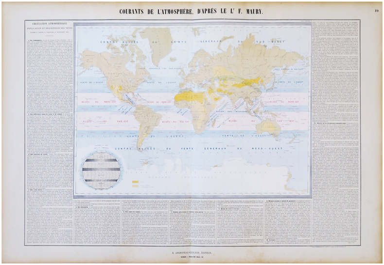
MAURY (Matthew Fontaine) & ANDRIVEAU-GOUJON (Eugène).
Courants de l'atmosphère, d'après le L.t F. Maury.
Paris, E. Andriveau-Goujon, 1864. En deux feuilles jointes de 665 x 887 mm.
Referencia librero : LBW-6843
|
|
|
MAURITANIE par Odette de PUIGAUDEAU.
La grande foire des dattes. Adrar mauritanien. Illustré (héliogravures, cartes).
Paris, éd. Plon 1937. Bon exemplaire broché, couverture décorée d'éd., in-8, 281 pages + planches.
Referencia librero : AUB-4024
|
|
|
Maurice Dodion, Wasily Pedjko
Prentkaarten Van Hoegaarden
Hoegaarden, Hoegaards Erfgoed VZW, 2024 Hardcover, 65 pagina's, 31 x 22 cm. talrijke afbeeldingen in kleur en z/w nieuwstaat
Referencia librero : 64622
|
|
|
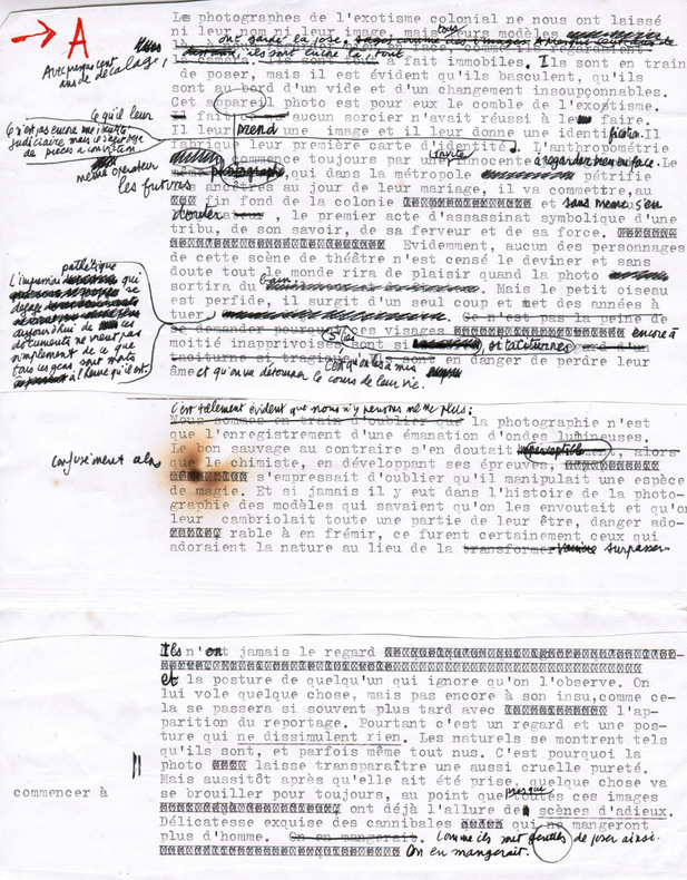
Maurel, Christian (1931-2011, écrivain et journaliste)
Tapuscrit de L'Exotisme colonial
1980 Ensemble comprenant : 1) Le tapuscrit de premier jet avec de nombreuses corrections autographes : environ 16 ff. in-4 assemblés ; 2) Le tapuscrit définitif, y compris tables, crédits photographiques, 4e de couverture... : 29 ff. in-4 souvent reconstitués ; 3) Instructions pour les retouches de photos : 3 pp. tapuscrites in-4 avec corrections autographes, 2 pp. manuscrites in-12.
Referencia librero : 2665
|
|
|
MAURIAC
Carte d'?tat-major ? l'?chelle 1/80 000?.
1 feuille entoil?e (repli?e). 60x84 cm. Mouillure en marge.
|
|
|
Maurice Colbeck
Village Yorkshire
No marks or inscriptions. A very clean very tight copy with bright unmarked boards and no bumping to corners. Dust jacket price clipped but not marked or torn or creased with minor traces of storage. 160pp. A tour around scores of Yorkshire villages. Well illustrated.

|
|
|
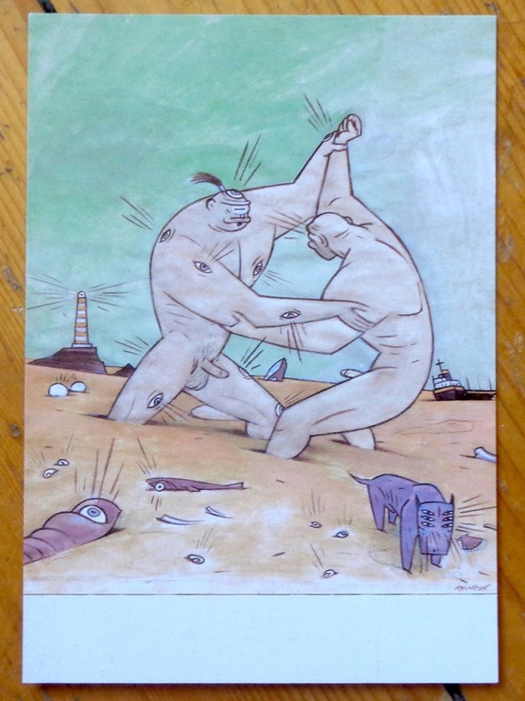
Max:
Argos and Cyclops playing on the beach.
Chez l'auteur, 1997. Avis de changement d'adresse du dessinateur, au format carte postale.
Referencia librero : 9047
|
|
|
Maxwell R.; Photos Fold out Maps Illustrator
Geologic and Historic Guide to the State Parks of Texas
University of Texas 1970-01-01. Paperback. Good. Trade Paperback. Good. General used condition. Evident wear. Initials on cover. Text block clean and unmarked. Tight binding. Book has a "wave" from not being stored flat. University of Texas paperback
Referencia librero : UTA1731012

|
|
|
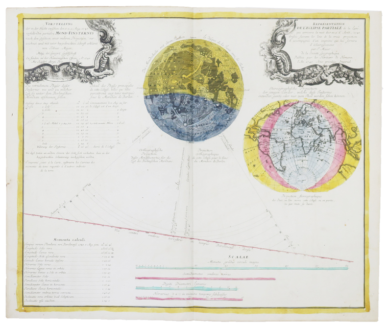
MAYER (Tobias).
[ÉCLIPSES] Représentation de l'éclipse partiale de la Lune, qui arrivera dans la nuit du 8 au 9 d'août 1748.
Nuremberg, Héritiers de Homann, 1748. 485 x 570 mm.
Referencia librero : LBW-4858
|
|
|
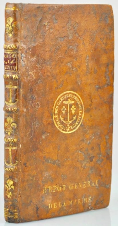
Mayerne Turquet (Louis de).
Discours sur la Carte universelle, en laquelle le Globe terrestre est entièrement réduit et représenté dans un seul cercle sans aucune division de ses parties, où il est traicté des défauts de toutes les autres cartes universelles, des advantages que celle-cy a sur elles et enfin respondu aux objections que l'on peut faire contre cette nouvelle manière de figurer le Globe.
Paris, l'Autheur, 1648. In-16 de (14)-83 pp., veau granité, dos à nerfs orné alternativement de fleur de lys et d'ancres marines, super libris à l'ancre fleudelisée sur le plat supérieur "Dépôt Général de la Marine”, tranches rouges (reliure du XVIIIe siècle).
Referencia librero : 42339
|
|
|
MAY Helmut - MILLER Henry
Hans Reichel. 1892-1958. Ein eutscher maler in Paris
Köln Wallraf-Richartz-Museum 1960 plaquette in-8 Agrafé, couverture illustrée
Referencia librero : 014320
|
|
|
MAYER, TOBIAS & HOMANN - POLAND.
Mappa Geographica Regni Poloniae ex novissimis quotquot sunt mappis specialibus composita at ad LL stereographica projectionis revocata a Tob. Mayero...
Nürnberg, Homannianos Heredes, 1773. 48,5x53,5 cm. Engraved and original hancoloured map of Poland and neighbouring areas. A tear in upper margin just touching the coloured image area. A very small hole in lower part of map in the folding.
Referencia librero : 32941
|
|
|
May, Dr Jacques M.
Thailand, Around the World Program; American Geographical Society
No marks or inscriptions. Tiny crease to lower corner of rear cover. A very clean very tight copy with very slightly dusty boards, rusty staples and no bumping to corners. All twenty-five coloured stickers present and attached. 64pp. An introduction to Thailand in the 1960s and earlier. Very well illustrated. We do not use stock photos, the picture displayed is of the actual book for sale. Every one of our books is in stock in the UK ready for immediate delivery.

|
|
|
May, Jutta
The Visitor's Guide to Corsica
Ex library book with usual marks and stamps. Clean tight pages with bright unmarked tape-free red cloth boards and no bumping to corners. Dust jacket not price clipped or marked or torn with creasing. 231pp. An ideal detailed guide for the independent motoring traveller in Corsica.

|
|
|
MAYER, TOBIAS & HOMANN - POLAND.
Mappa Geographica Regni Poloniae ex novissimis quotquot sunt mappis specialibus composita at ad LL stereographica projectionis revocata a Tob. Mayero...
Nürnberg, Homannianos Heredes, 1773. 48,5x53,5 cm. Engraved and original hancoloured map of Poland and neighbouring areas. A tear in upper margin just touching the coloured image area. A very small hole in lower part of map in the folding.
|
|
|
MAYO LIDA & HARDYMAN ARTHUR S. Illus maps
Bloody Buna
Doubleday & Company 1974. First edition octavo hardcover VG in d/w VG; all our specials have minimal description to keep listing them viable. They are at least reading copies complete and in reasonable condition but usually secondhand; frequently they are superior examples. Ordering more than one book will reduce your overall postage costs Doubleday & Company 1974 hardcover
Referencia librero : 220380
|
|
|
MAZIERS, Micel.
Rhode-Saint-Genèse en cartes postales anciennes.- Sint-Genesius-Rode in oude prentkaarten.
Zaltbommel, Bibliotheque Europeenne, 1973. Petit in-8 oblong, 76 cartes en n&b., reliure cartonnage editeur illustrée.- RARE
Referencia librero : 81534

|
|
|
MAZIERS, Micel.
Rhode-Saint-Genèse en cartes postales anciennes.- Sint-Genesius-Rode in oude prentkaarten.
Petit in-8 oblong, 76 cartes en n&b., reliure cartonnage editeur illustrée.- RARE Bel exemplaire. [BU-11]
|
|
|
MCALESTER VIRGINIA & LEE; GUYTON TERRY & MALPHURS GREG MAPS; GUTHRIE JERRY MAP EDITOR; ARCHITEXAS DRAWINGS
A Field Guide To America's Historic Neighborhoods And Museum Houses: The Western States
Alfred A. Knopf New York: 1998. Hardcover with dustjacket in protective mylar cover. Very good condition. Library discard. This information-packed new field guide shows us houses well worth looking at and the neighborhoods in which we can find many of them in 110 cities and towns in seventeen western states: Arizona California Colorado Idaho Kansas Montana Nebraska Nevada New Mexico North Dakota Oklahoma Oregon South Dakota Texas Utah Washington and Wyoming. The 172 historic neighborhoods covered contain hundreds of interesting dwellings that can be viewed without ceremony from the street - and almost 200 museum houses of particular architectural and/or artistic significance whose interiors can be visited. Includes an Index maps and numerous photos. ISBN: 0679425691. Alfred A. Knopf, New York: 1998 hardcover
Referencia librero : 27751X1 ISBN : 0679425691 9780679425694

|
|
|
McCarta, Robertson
Cyprus (Nelles guides)
Clean neat copy, comprehensive travel guide to Cyprus. 256p. illus (col) index. Neat and complete, with one library "sold" stamp P Ex-Library
|
|
|
McClellan, George B.
REPORT ON THE ORGANIZATION AND CAMPAIGNS OF THE ARMY OF THE POTOMAC: To Which Is Added An Account Of The Campaign In Western Virginia, With Plans Of Battle-Fields.
pp. 465, (14) [Publisher's catalogue] + Frontis folding map of Antietam battle field, old tape repair at top fold, and full page plans of battle fields. Age stained. Inked ownership of H. R. Pratt, 1935. Large 12mo. Original full cloth binding, lacks spine. Hardbound. SHELF W29
|
|
|
McCorquodale, Anna (editor)
Debrett's Cities of the World : London
No marks or inscriptions. No creasing to covers or to spine. A very clean very tight copy with bright unmarked boards and no bumping to corners. 303pp. The volume which is distributed to peers and baronets, chairmen, managing directors, Members of Parliament, and Members of the European Parliament and others selected from Debretts (of Debrett's Peerage Ltd fame) - primarily those living within a 150 mile radius of London. A limited number is circulated among London's top hotels. A heavy book.

|
|
|
McCoy, Alfred W.; Read, Cathleen R.; Adams, Leonard P.
The Politics of Heroin in Southeast Asia
464 pages including notes, index, black and white photographic plates and illustrations. "In spite of recent well-publicized seizures of massive shipments of heroin from Southeast Asia, heroin continues to flood the country, spreading into every level of this society and shredding the fabric of everyday life. U.S. government estimates of the number of addicts has leaped from 315,000 in 1969 to over 560,000 in 1972. This book puts all the pieces of this ghastly puzzle together, and then maps the possible avenues out of the horror, suggesting that America may have to choose between our commitments in Southeast Asia and getting heroin out of our high schools." - from dust jacket. Moderate wear. Book clean and unmarked. Small closed tear to dust jacket. Nice copy. Book
|
|
|
McCrossan Moira & Taylor Hugh
Jordan Globetrotter Travel Guide
United Kingdom: New Holland Publishers 2009 Information tips and recommendations accompanied by colour photographs charts and maps for the first-time traveller who wants to experience the major highlights that Jordan has to offer. In plastic sleeve and includes a nice fold-out map of Jordan. Plastic Cover. New. New Holland Publishers paperback
Referencia librero : 26730 ISBN : 1847734944 9781847734945

|
|
|
McDonnell Patrick:
Triptyque Earl & Mooch.
Les Humanoïdes Associés. Ravissant triptyque de présentation, à l'état de neuf.
Referencia librero : 5406

|
|
|
McDougall, Duncan
Victoria : The Garden City
Inscription inside front cover and light indenting to front cover. No other marks, light creasing to covers and spine. A clean very tight copy with lightly rubbed covers and no bumping to corners. 72pp. With coloured photographs and black & white line drawings of this Canadian city with a little text.

|
|
|
McDowell, Jim
Uncharted Waters the Explorations of Jose Narvaez (1768 - 1840)
Ex-library book with the usual stamps, stickers, etc. Binding is solid and text/interior is clean and free of marking of any kind. Barely used; interior is perfect, covers show no wear, maps, b&w illustrations throughout.
|
|
|
McElfresh Earl B
Maps and Mapmakers of the Civil War
Boston Massachusetts U.S.A.: Harry N Abrams Inc 1999. 272pp/180 illustrations including 150 plates in full color. The largest most comprehensive & most beautifully illustrated collection of Civil War maps ever published. Still shrink wrapped. First Edition. Hard Cover. New/New. 4to - over 9�" - 12" tall. Harry N Abrams Inc hardcover
Referencia librero : 007290 ISBN : 0810934302 9780810934306

|
|
|
McElfresh Earl B
MAPS AND MAPMAKERS OF THE CIVIL WAR
New York: Abrams Image 1999. 272pp. Biblio & index. 180 illustrations including 150 color plates. History Book Cub edition. Paper-covered Boards. Very Fine/Very Fine. Large 4to. Abrams Image Hardcover
Referencia librero : 16280 ISBN : 0810934302 9780810934306
|
|
|
McEvedy Colin
The Penguin Atlas of Medieval History
London: Penguin 1971 96pmaps. index. Reprint. Softcover. Good. Penguin unknown
Referencia librero : 32021 ISBN : 0140708227 9780140708226

|
|
|
MCEVEDY COLIN TEXT; WOODCOCK JOHN MAPS
The Penguin Atlas Of Ancient History
Penguin Books Harmondsworth: 1975. Softcover. Reading copy. Illustrates in a chronological series of maps the evolution and flux of races in Europe the Mediterranean area and the Near East. From 50000 B.C. to the fourth century A.D. the maps and their accompanying commentaries follows the ages of stone bronze and iron and trace the movements and cultural developments of Mesopoltamian Egyptians Indians Hittites Assyrians Greeks Persians Celts Etruscans Carthaginians Goths Romans and many other peoples. Includes an Index. ISBN: 0140708324. Penguin Books, Harmondsworth: 1975 paperback
Referencia librero : 66403X1 ISBN : 0140708324 9780140708325

|
|
|
McEvedy, Colin
The Penguin Atlas of Medieval History & The Penguin Atlas of Modern History (to 1815)
Penguin Books, (Middlesex) 1972. 2x96 S., 18cm Karton 0
Referencia librero : 74807

|
|
|
McGonagle, Declan & Badger, Gerry
Troubled Land : The Social Landscape of Northern Ireland
Previous owner's bookplate to front end paper. No marks or inscriptions. Extremely faint crease to front cover, none to rear or to spine. A lovely clean very tight copy with bright unmarked boards and no bumping to corners. 80pp. This work of full-page colour photographs by Paul Graham deals with the small but insistent signs of deep political division within the landscape of Northern Ireland in the 1980s. 'The foreword by Declan McGonagle contrasts the work against the melodramatic imagery of the North and places the Troubles in a broader framework of the marginalisation and denial of power that has been the hallmark of British cononialism for centuries. The main text by Gerry Badger examines the genre of reportage photography and positions this work within a new generation of intelligent documentary photography that represents ideas rather than furnishing simple visual records or illustrating words.'

|
|
|
McKenzie John D./Queman Beth maps
Uncertain Glory: Lee's Generalship Re-Examined
NY: Hippocrene Books 1997. 2nd printing. Fine/Fine. 384 p. maps notes biblio index 8vo; Hippocrene Books hardcover
Referencia librero : 36907 ISBN : 0781805023 9780781805025
|
|
|
McKenzie John D./Queman Beth maps
Uncertain Glory: Lee's Generalship Re-Examined
NY: Hippocrene Books 1997. 2nd printing. Fine/Fine. 384 p. maps notes biblio index 8vo; Hippocrene Books hardcover
Referencia librero : 22209 ISBN : 0781805023 9780781805025
|
|
|
McKenzie John D./Queman Beth maps
Uncertain Glory: Lee's Generalship Re-Examined
NY: Hippocrene Books 1997. 2nd printing. Fine/Fine. 384 p. maps notes biblio index 8vo; Hippocrene Books hardcover
Referencia librero : 21207 ISBN : 0781805023 9780781805025
|
|
|
McLean, Allan Campbell
Explore the Highlands and Islands
No marks or inscriptions. Faint creasing to covers. A very clean very tight copy with bright unmarked boards, traces of foxing to page edges and no bumping to corners. 63pp. Publicity brochure for parts of Scotland.

|
|
|
McMinnies, W. G.
Signpost : An Intimate and Independent Guide to Pleasant Ports of Call 1959
No marks or inscriptions. A very clean very tight copy with bright unmarked boards and no bumping to corners. Dust jacket not price clipped or marked or torn or creased with minor traces of rubbing and handling. 400pp. A guide to places to visit and stay in Britain, the Channel Isles, Orkney and Scilly

|
|
|
McNally, Rand
Northeastern U.S. Road Atlas and Travel Guide
Boston u.a., Rand McNally & Company, 1990. Broschur, mit farbigem Deckelphoto, Metall-Spiralbindung, ca. DinA 4, 198 Seiten, durchgehend farbige Kartenskizzen, 2 auffaltbare lose Kartenskizzen liegen bei, Einband mit Gebrauchsspuren, Knickspuren, altes Preisschild (lässt sich MÖGLICHERWEISE nicht lösen) am oberen Vorderdeckel, zum Rücken unten minimal eingerissen, Seiten minimal randbeschabt, insgesamt gut erhalten / insgesamt guter Zustand [5 Warenabbildungen]
Referencia librero : 30687ge

|
|
|
McReynolds Don 1990 Maps By.
Hydrologic Atlas for Parmer County Texas
Lubbock Texas: Higfh Plains Underground Water Conserv. Dist. 1990. Book. Eight page explanatory booklet accompannied by four large folded hydrologic maps. Depicting the depth of land surface to water at any point in Parmer County Texas and by extension. a resource for determining water tables well water land management and agricultural concerns.Mapping by D.D. Smith geologist. Fine In original envelope. Higfh Plains Underground Water Conserv. Dist. unknown
Referencia librero : 121519
|
|
|
McReynolds Don 1990 Maps By.
Hydrologic Atlas for Floyd County Texas
Lubbock Texas: Higfh Plains Underground Water Conserv. Dist. 1990. Book. Eight page explanatory booklet accompannied by four large folded hydrologic maps. Depicting the depth of land surface to water at any point in Floyd County Texas and by extension. a resource for well water waer tables land management and agricultural concerns.Mapping by D.D. Smith geologist. Fine In original envelope. Higfh Plains Underground Water Conserv. Dist. unknown
Referencia librero : 121520

|
|
|
McReynolds Don 1990 Maps By.
Hydrologic Atlas for Crosby County Texas
Lubbock Texas: Higfh Plains Underground Water Conserv. Dist. 1990. Book. Eight page explanatory booklet accompannied by four large folded hydrologic maps. Depicting the depth of land surface to water at any point in Crosby County Texas and by extension. a resource for well water land management water tables and agricultural concerns.Mapping by D.D. Smith geologist. Fine In original envelope. Higfh Plains Underground Water Conserv. Dist. unknown
Referencia librero : 121521

|
|
|
McReynolds Don 1992 Maps By.
Hydrologic Atlas for Castro County Texas
Lubbock Texas: Higfh Plains Underground Water Conserv. Dist. 1992. Book. Eight page explanatory booklet accompannied by four large folded hydrologic maps. Depicting the depth of land surface to water at any point in Castro County Texas and by extension. a resource for determining water tables well water land management and agricultural concerns.Mapping by D.D. Smith geologist. Fine In original envelope. Higfh Plains Underground Water Conserv. Dist. unknown
Referencia librero : 121522

|
|
|
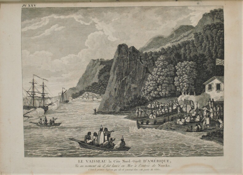
MEARES , Capitaine John
Voyages de la Chine à la cote nord-ouest d'Amérique, faits dans les années 1788 et 1789 Précédé de la relation d'un autre voyage exécuté en 1786 sur le vaisseau le Nootra, parti du Bengale D'un recueil d'observations sur la probabilité d'un passage au nord-ouest Et d'un traité abrégé du commerce entre la côte nord-ouest et la Chine, etc. etc. Capitaine John MEARES, commandant le Vaisseau la Felice Traduit de l'anglois par J.B.L.J. Billecocq, citoyen français. Avec une collection de cartes géographiques, vues, plans et portraits, gravés en taille-douce.
Paris , chez Buisson , An 3 de la République (1795) , 3 volumes In 8° ( 210x130 mm), couverture d’attente avec un Atlas de 28 planches, grand in 4° (300x230 mm) , XXIV-391pp, (4) 386pp, et (4) 371pp. L'atlas se compose ainsi, page de titre 1ff n.c., table des planches, 28 planches HT, portraits, cartes, plans, vue.Tache sur la liste des planches , quelques planches brunies ,déchirure sans manque à la carte. Texte ,manques aux dos , bords usés et brunis .
Referencia librero : PHO-1017
|
|
|
Med Maps
Martha's Vineyard Pictorial Guide
Unknown. Paperback. GOOD. Spine creases wear to binding and pages from reading. May contain limited notes underlining or highlighting that does affect the text. Possible ex library copy will have the markings and stickers associated from the library. Accessories such as CD codes toys may not be included. Unknown paperback
Referencia librero : 3196258447 ISBN : 1890463183 9781890463182
|
|
|
Med Maps
Martha's Vineyard Pictorial Guide
Unknown 1999. Paperback. Very Good. Disclaimer:A copy that has been read but remains in excellent condition. Pages are intact and are not marred by notes or highlighting but may contain a neat previous owner name. The spine remains undamaged. At ThriftBooks our motto is: Read More Spend Less.Dust jacket quality is not guaranteed. Unknown paperback
Referencia librero : G1890463183I4N00 ISBN : 1890463183 9781890463182

|
|
|
Med Maps
Martha's Vineyard Pictorial Guide
Unknown. Used - Very Good. Very Good condition. Unknown unknown
Referencia librero : E03B-01095 ISBN : 1890463183 9781890463182
|
|
|
Meds Maps
Nantucket A pictorial guide
Good. No Hassle 30 Day Returns Ships Daily Underlining/Highlighting: NONE Writing: None unknown
Referencia librero : 6028898 ISBN : 1890463248 9781890463243
|
|
|
Meds Maps
New England Lighthouses A Pictorial Guide
Meds Maps Inc 1/1/9999. Hardcover. New. Hardcover. Fine binding and cover. Clean unmarked pages. Ships daily. Meds Maps Inc hardcover
Referencia librero : 1308100022 ISBN : 1890463116 9781890463113
|
|
 Recibir por correo electrónico
 Descargar en documento PDF
 Flujo RSS


