|
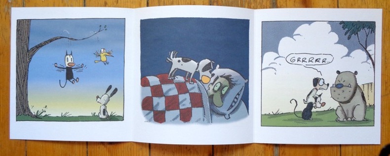
McDonnell Patrick:
Triptyque Earl & Mooch.
Les Humanoïdes Associés. Ravissant triptyque de présentation, à l'état de neuf.
书商的参考编号 : 5406
|
|
|
McDougall, Duncan
Victoria : The Garden City
Inscription inside front cover and light indenting to front cover. No other marks, light creasing to covers and spine. A clean very tight copy with lightly rubbed covers and no bumping to corners. 72pp. With coloured photographs and black & white line drawings of this Canadian city with a little text.

|
|
|
McDowell, Jim
Uncharted Waters the Explorations of Jose Narvaez (1768 - 1840)
Ex-library book with the usual stamps, stickers, etc. Binding is solid and text/interior is clean and free of marking of any kind. Barely used; interior is perfect, covers show no wear, maps, b&w illustrations throughout.
|
|
|
McElfresh Earl B
Maps and Mapmakers of the Civil War
Boston Massachusetts U.S.A.: Harry N Abrams Inc 1999. 272pp/180 illustrations including 150 plates in full color. The largest most comprehensive & most beautifully illustrated collection of Civil War maps ever published. Still shrink wrapped. First Edition. Hard Cover. New/New. 4to - over 9�" - 12" tall. Harry N Abrams Inc hardcover
书商的参考编号 : 007290 ???????? : 0810934302 9780810934306

|
|
|
McElfresh Earl B
MAPS AND MAPMAKERS OF THE CIVIL WAR
New York: Abrams Image 1999. 272pp. Biblio & index. 180 illustrations including 150 color plates. History Book Cub edition. Paper-covered Boards. Very Fine/Very Fine. Large 4to. Abrams Image Hardcover
书商的参考编号 : 16280 ???????? : 0810934302 9780810934306
|
|
|
McEvedy Colin
The Penguin Atlas of Medieval History
London: Penguin 1971 96pmaps. index. Reprint. Softcover. Good. Penguin unknown
书商的参考编号 : 32021 ???????? : 0140708227 9780140708226

|
|
|
MCEVEDY COLIN TEXT; WOODCOCK JOHN MAPS
The Penguin Atlas Of Ancient History
Penguin Books Harmondsworth: 1975. Softcover. Reading copy. Illustrates in a chronological series of maps the evolution and flux of races in Europe the Mediterranean area and the Near East. From 50000 B.C. to the fourth century A.D. the maps and their accompanying commentaries follows the ages of stone bronze and iron and trace the movements and cultural developments of Mesopoltamian Egyptians Indians Hittites Assyrians Greeks Persians Celts Etruscans Carthaginians Goths Romans and many other peoples. Includes an Index. ISBN: 0140708324. Penguin Books, Harmondsworth: 1975 paperback
书商的参考编号 : 66403X1 ???????? : 0140708324 9780140708325

|
|
|
McEvedy, Colin
The Penguin Atlas of Medieval History & The Penguin Atlas of Modern History (to 1815)
Penguin Books, (Middlesex) 1972. 2x96 S., 18cm Karton 0
书商的参考编号 : 74807

|
|
|
McGonagle, Declan & Badger, Gerry
Troubled Land : The Social Landscape of Northern Ireland
Previous owner's bookplate to front end paper. No marks or inscriptions. Extremely faint crease to front cover, none to rear or to spine. A lovely clean very tight copy with bright unmarked boards and no bumping to corners. 80pp. This work of full-page colour photographs by Paul Graham deals with the small but insistent signs of deep political division within the landscape of Northern Ireland in the 1980s. 'The foreword by Declan McGonagle contrasts the work against the melodramatic imagery of the North and places the Troubles in a broader framework of the marginalisation and denial of power that has been the hallmark of British cononialism for centuries. The main text by Gerry Badger examines the genre of reportage photography and positions this work within a new generation of intelligent documentary photography that represents ideas rather than furnishing simple visual records or illustrating words.'

|
|
|
McKenzie John D./Queman Beth maps
Uncertain Glory: Lee's Generalship Re-Examined
NY: Hippocrene Books 1997. 2nd printing. Fine/Fine. 384 p. maps notes biblio index 8vo; Hippocrene Books hardcover
书商的参考编号 : 36907 ???????? : 0781805023 9780781805025
|
|
|
McKenzie John D./Queman Beth maps
Uncertain Glory: Lee's Generalship Re-Examined
NY: Hippocrene Books 1997. 2nd printing. Fine/Fine. 384 p. maps notes biblio index 8vo; Hippocrene Books hardcover
书商的参考编号 : 22209 ???????? : 0781805023 9780781805025
|
|
|
McKenzie John D./Queman Beth maps
Uncertain Glory: Lee's Generalship Re-Examined
NY: Hippocrene Books 1997. 2nd printing. Fine/Fine. 384 p. maps notes biblio index 8vo; Hippocrene Books hardcover
书商的参考编号 : 21207 ???????? : 0781805023 9780781805025
|
|
|
McLean, Allan Campbell
Explore the Highlands and Islands
No marks or inscriptions. Faint creasing to covers. A very clean very tight copy with bright unmarked boards, traces of foxing to page edges and no bumping to corners. 63pp. Publicity brochure for parts of Scotland.

|
|
|
McMinnies, W. G.
Signpost : An Intimate and Independent Guide to Pleasant Ports of Call 1959
No marks or inscriptions. A very clean very tight copy with bright unmarked boards and no bumping to corners. Dust jacket not price clipped or marked or torn or creased with minor traces of rubbing and handling. 400pp. A guide to places to visit and stay in Britain, the Channel Isles, Orkney and Scilly

|
|
|
McNally, Rand
Northeastern U.S. Road Atlas and Travel Guide
Boston u.a., Rand McNally & Company, 1990. Broschur, mit farbigem Deckelphoto, Metall-Spiralbindung, ca. DinA 4, 198 Seiten, durchgehend farbige Kartenskizzen, 2 auffaltbare lose Kartenskizzen liegen bei, Einband mit Gebrauchsspuren, Knickspuren, altes Preisschild (lässt sich MÖGLICHERWEISE nicht lösen) am oberen Vorderdeckel, zum Rücken unten minimal eingerissen, Seiten minimal randbeschabt, insgesamt gut erhalten / insgesamt guter Zustand [5 Warenabbildungen]
书商的参考编号 : 30687ge

|
|
|
McReynolds Don 1990 Maps By.
Hydrologic Atlas for Parmer County Texas
Lubbock Texas: Higfh Plains Underground Water Conserv. Dist. 1990. Book. Eight page explanatory booklet accompannied by four large folded hydrologic maps. Depicting the depth of land surface to water at any point in Parmer County Texas and by extension. a resource for determining water tables well water land management and agricultural concerns.Mapping by D.D. Smith geologist. Fine In original envelope. Higfh Plains Underground Water Conserv. Dist. unknown
书商的参考编号 : 121519
|
|
|
McReynolds Don 1990 Maps By.
Hydrologic Atlas for Floyd County Texas
Lubbock Texas: Higfh Plains Underground Water Conserv. Dist. 1990. Book. Eight page explanatory booklet accompannied by four large folded hydrologic maps. Depicting the depth of land surface to water at any point in Floyd County Texas and by extension. a resource for well water waer tables land management and agricultural concerns.Mapping by D.D. Smith geologist. Fine In original envelope. Higfh Plains Underground Water Conserv. Dist. unknown
书商的参考编号 : 121520

|
|
|
McReynolds Don 1990 Maps By.
Hydrologic Atlas for Crosby County Texas
Lubbock Texas: Higfh Plains Underground Water Conserv. Dist. 1990. Book. Eight page explanatory booklet accompannied by four large folded hydrologic maps. Depicting the depth of land surface to water at any point in Crosby County Texas and by extension. a resource for well water land management water tables and agricultural concerns.Mapping by D.D. Smith geologist. Fine In original envelope. Higfh Plains Underground Water Conserv. Dist. unknown
书商的参考编号 : 121521

|
|
|
McReynolds Don 1992 Maps By.
Hydrologic Atlas for Castro County Texas
Lubbock Texas: Higfh Plains Underground Water Conserv. Dist. 1992. Book. Eight page explanatory booklet accompannied by four large folded hydrologic maps. Depicting the depth of land surface to water at any point in Castro County Texas and by extension. a resource for determining water tables well water land management and agricultural concerns.Mapping by D.D. Smith geologist. Fine In original envelope. Higfh Plains Underground Water Conserv. Dist. unknown
书商的参考编号 : 121522

|
|
|
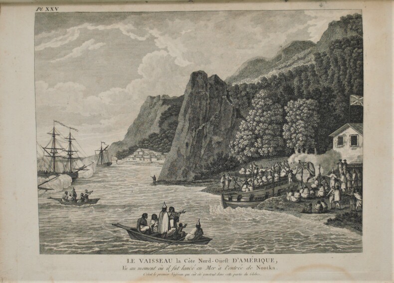
MEARES , Capitaine John
Voyages de la Chine à la cote nord-ouest d'Amérique, faits dans les années 1788 et 1789 Précédé de la relation d'un autre voyage exécuté en 1786 sur le vaisseau le Nootra, parti du Bengale D'un recueil d'observations sur la probabilité d'un passage au nord-ouest Et d'un traité abrégé du commerce entre la côte nord-ouest et la Chine, etc. etc. Capitaine John MEARES, commandant le Vaisseau la Felice Traduit de l'anglois par J.B.L.J. Billecocq, citoyen français. Avec une collection de cartes géographiques, vues, plans et portraits, gravés en taille-douce.
Paris , chez Buisson , An 3 de la République (1795) , 3 volumes In 8° ( 210x130 mm), couverture d’attente avec un Atlas de 28 planches, grand in 4° (300x230 mm) , XXIV-391pp, (4) 386pp, et (4) 371pp. L'atlas se compose ainsi, page de titre 1ff n.c., table des planches, 28 planches HT, portraits, cartes, plans, vue.Tache sur la liste des planches , quelques planches brunies ,déchirure sans manque à la carte. Texte ,manques aux dos , bords usés et brunis .
书商的参考编号 : PHO-1017
|
|
|
Med Maps
Martha's Vineyard Pictorial Guide
Unknown. Paperback. GOOD. Spine creases wear to binding and pages from reading. May contain limited notes underlining or highlighting that does affect the text. Possible ex library copy will have the markings and stickers associated from the library. Accessories such as CD codes toys may not be included. Unknown paperback
书商的参考编号 : 3196258447 ???????? : 1890463183 9781890463182
|
|
|
Med Maps
Martha's Vineyard Pictorial Guide
Unknown 1999. Paperback. Very Good. Disclaimer:A copy that has been read but remains in excellent condition. Pages are intact and are not marred by notes or highlighting but may contain a neat previous owner name. The spine remains undamaged. At ThriftBooks our motto is: Read More Spend Less.Dust jacket quality is not guaranteed. Unknown paperback
书商的参考编号 : G1890463183I4N00 ???????? : 1890463183 9781890463182

|
|
|
Med Maps
Martha's Vineyard Pictorial Guide
Unknown. Used - Very Good. Very Good condition. Unknown unknown
书商的参考编号 : E03B-01095 ???????? : 1890463183 9781890463182
|
|
|
Meds Maps
Nantucket A pictorial guide
Good. No Hassle 30 Day Returns Ships Daily Underlining/Highlighting: NONE Writing: None unknown
书商的参考编号 : 6028898 ???????? : 1890463248 9781890463243
|
|
|
Meds Maps
New England Lighthouses A Pictorial Guide
Meds Maps Inc 1/1/9999. Hardcover. New. Hardcover. Fine binding and cover. Clean unmarked pages. Ships daily. Meds Maps Inc hardcover
书商的参考编号 : 1308100022 ???????? : 1890463116 9781890463113
|
|
|
Meds Maps
New England Lighthouses A Pictorial Guide
Meds Maps Inc. Hardcover. Good. Meds Maps Inc hardcover
书商的参考编号 : SONG1890463116 ???????? : 1890463116 9781890463113
|
|
|
Meds Maps editors of
Nantucket a pictorial guide
Harwich MA: Meds Maps no date. presumed 1st . Soft cover. Fine. 25826 shelf. Unpaginated slim trade paperback photo covers. No names clean text. With stunning color photos. Printed in Italy. Fresh! <br/> <br/> Meds Maps, no date paperback
书商的参考编号 : 069862 ???????? : 1890463248 9781890463243
|
|
|
Mee, Arthur
Derbyshire : The King's England
No marks or inscriptions to contents. No creasing to covers or to spine. Clean very tight pages with lightly marked red cloth boards, rubbing to ends of sunned spine and to corners. 290pp. First Edition of the classic King's England study of Derbyshire.

|
|
|
Mee, Arthur
London: City and Westminster (King's England S.)
No marks or inscriptions. A very clean very tight copy with bright unmarked boards and no bumping to corners. Dust jacket not price clipped or marked or torn or creased with the tiniest of nicks to top of spine. 436pp. Fully revised new edition of Arthur Mee's classic series.

|
|
|
Mee, Arthur; Saunders, Ann; Kersting, Anthony F.
London North of the Thames except the City and Westminster
Ex-library copy with usual (minimal) marks and stamps - to front end paper and reverse of title page only. (Why? did the library release the book??) Other than the two ex-library marks, the book and jacket are both 'fine'. No other marks or inscriptions. A very clean very tight copy with bright unmarked boards and no bumping to corners. Dust jacket not price clipped or marked or torn or creased. 432pp.

|
|
|
MEES V.
L'ellipse de Tissot et ses applications en cartograpphie. Collection U, N° 18.
Kinshasa, Ed. Centre de Recherches Pédagogiques, s.d. (ca 1980). 15 x 20, 25 pp., 19 figures, broché, très bon état.
书商的参考编号 : 91153
|
|
|
MEES V.
Les planisphères de la terre en projection cylindrique directe. Collection U, N° 19.
Kinshasa, Ed. Centre de Recherches Pédagogiques, s.d. (ca 1980). 15 x 20, 32 pp., 14 figures, broché, très bon état.
书商的参考编号 : 91152
|
|
|
MEGRET Luc.
Tous les Jeux de cartes anciens et modernes avec la manière de gagner à l'écarté, à la manille et au poker, suivis de 21 jeux inédits et d'un tableau de la classification des cartes en cartomancie.
Paris, Garnier Frères, 1945, in-8 de 182 pages, sobre reliure pleine toile en très bon état, couverture de l'édition brochée conservée, jtitre doré sur pièce de titre sur dos lisse. Corps frais, reliure solide, un tampon en tête de la grande page de titre. Bon exemplaire.
书商的参考编号 : 21996
|
|
|
Mehling Dr. Marianne Editor; Illustrations Photograps Maps Illustrator
Athens and Attica
Hungry Minds IncU.S 1986-07-21. Hardcover. New. Hungry Minds Inc,U.S hardcover
书商的参考编号 : 170604019 ???????? : 0130498912 9780130498915
|
|
|
Mehling, Franz M (editor)
Paris and the Ile de France
No marks or inscriptions. Clean bright laminated boards with no bumping to corners. A lovely clean crisp tight copy. 259pp. Phaidon Cultural Guide. Laminated boards. Very well illustrated in colour.

|
|
|
MEHMET SEVKI PASA, (1866-1927).
Çanakkale tâhkimât haritasi. [= Fortifications maps of Gallipoli War]. Edited by Ahmet Tetik, Ayse Seven.
New English Paperback. Folio. (42 x 30 cm). In English and Turkish. [96] p., color maps. Çanakkale tahkimat haritasi. [= Fortifications maps of Gallipoli War]. Edited by Ahmet Tetik, Ayse Seven.
|
|
|
Meier, Peter.
100 mal Philatelie. De la Philatélie par 100. Philately, a 100 times.
Bern, Museum für Kommunikation 2000, 215x215mm, 208Seiten, Verlegereinband. Exemplar wie neu.
书商的参考编号 : 59549

|
|
|
MEISNER Daniel (Attivo nella prima metà del XVII sec.)
Roma caput terrae, si legis, est, retrò, Amor.
Veduta tratta dall'edizione del 1678 della celebre Sciagraphia Cosmica nota anche con il titolo Das ist Newes Emblematisches Buechlei, dainen in acht Centurijs die vornembste Stat, Vestung, Schlosser der ganzen Welt... stampata a Norinberga. La Sciagraphia Cosmica, venne ampliata sotto la supervisione di Kieser dopo la morte di Meisner nel 1625, arrivando quindi ad una composizione di 800 magnifiche incisioni. Ogni opera è caratterizzata da un motto sopra l'immagine, e da versi emblematici (in latino o tedesco). L'opera è la combinazione di due generi allora popolari, il libro degli stemmi e il "Teatro delle città". Tra i maestri incisori e miniatori che contribuirono a questa serie ci sono Matthäus Merian, Sebastian Furck, Christian Stimmer e forse anche Meisner stesso, che concepì l'opera e contribuì a buona parte della prosa. Incisione in rame, con margini, in perfetto stato di conservazione. Panorama of the city, taken from the 1678 edition of the famous "Sciagraphia Cosmica" with the title "Das ist Newes Emblematisches Buechlei, dainen in acht Centurijs die vornembste Stat, Vestung, Schlosser der ganzen Welt...Nuremberg, 1678''. "Of little topographical interest, the view shows the Capitoline Hill emerging from the adjacent urban fabric, while the view to the left closes in on a scarcely recognizable St. Peter's. The author's name is only written on the title page. In addition to Meisner himself, the engravers involved included Merian, Furck and Stimmer" (cf. Marigliani p. 194). The Sciagraphia Cosmica was expanded under the supervision of Kieser after Meisner's death in 1625, resulting in a composition of 800 magnificent engravings. Each engraving is characterised by a motto above the image and emblematic verses (in Latin or German). The work is a combination of two popular genres, the Book of Coats of Arms and the Book of City Plants. Among the master engravers and illuminators who contributed to this series are Matthäus Merian, Sebastian Furck, Christian Stimmer and possibly Meisner himself, who conceived the work and contributed much of the prose. Copper engraving, with margins, in perfect condition. Cremonini pagg. 57/58, 45a; C. Marigliani, "Le Piante di Roma delle collezioni private", tav. 97.

|
|
|
Meissen:
Meissen. "Plan der Action, welche d. 20. Sept. 1759 zwischen einem Corps der combinirten Österreichischen und Reichs Armee und einem Preussischen Corps ohnweit Meissen in Sachsen vorgefallen". Schlachtenplan von Meissen in Sachsen, links mit Legende. Kupferstich mit farbigen Truppenaufstellungen aus "Neues Kriegs-Theater", 10. Supplement.
Format: 18 x 29,5 cm. *Leicht gebräunt, insgesamt gut erhalten. Landkarten de
|
|
|
Meißner, [Udo]
Kartenlesen und Entfernungsschätzen für Deutschlands Jugend. Erläutert an Beispielen. 2. Aufl.
Dresden-N. C. Heinrich, [1922]. 43 S. Mit 1 Abb. u. 1 mehrf. gefalt. Kte. 19 cm. OKart. mit VDeckel-Illustr.
书商的参考编号 : 84688

|
|
|
Mejer, Johannes (Kartogr. u. Hrsg.)
Landtcarte Von dem Lande Wageren. Welches ist das Ostertheil Von Holstein anno 1651. Altkolorierte Kupferstichkarte von Matthias & Nicolaus Peters, Husum.
o.J. 50,5 x 42,5 cm. [Aus: C. Danckwerth, Newe Landesbeschreibung... 1652]. Gerahmt.
书商的参考编号 : 86076
|
|
|
MELA (Pomponius).
Cosmographia, sive de situ orbis.
Venice, Erhard Ratdolt, 18 Juillet 1482. 1482 1 vol. in-8° (218 x 158 mm) de : [1] f. (dont carte du monde gravée et rehaussée en frontispice), [46] ff. (Titre en rouge, grandes et petites lettrines gravées sur bois). Nombreuses annotations manuscrites d'époque à l'encre brune dans les marges. Plein vélin ancien, tranche-fils traversant les coiffes, traces de lacets et de titrage à l'encre brune. (Salissures et défauts d'usage).
书商的参考编号 : 4142
|
|
|
MELI
La Casa de los Dali en Port-Lligat (Cadaques)
Figueras 0 Cartes postales sous couvertures illustrées En accordéon, couverture illustrée
书商的参考编号 : 009177
|
|
|
MELLING (Antoine-Ignace).
Vue générale du port de Constantinople prise des hauteurs d'Eyoub.
1819. 512 x 895 mm.
书商的参考编号 : LBW-8253

|
|
|
Melton Eduardo Cartes
Oxygen Wars
2018-10-19. New. Ships with Tracking Number! INTERNATIONAL WORLDWIDE Shipping available. May be re-issue. Buy with confidence excellent customer service! unknown
书商的参考编号 : 0578405776n ???????? : 0578405776 9780578405773

|
|
|
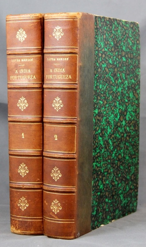
MENDES M. Lopes:
A India portugueza. Breve Descripçao das possessoes portugezas na Asia.
Lisboa, Imprensa Nacional, 1886. 2 vol. in-8 de XXVII-281 + XII-313-[2] pages, demi-basane marron, dos à nerfs orné de filet et fleurons dorés. Dos passés, quelques griffures aux dos, coiffes épiderméess rousseurs.
书商的参考编号 : 2149
|
|
|
Menocal, A. G. [Civil Engineer].
REPORT OF THE U. S. NICARAGUA SURVEYING PARTY, 1885. 49th Congress, 1st Session. Senate. Ex. Doc. No. 99.
pp. 55, (1), Folding Sketch of Lines and Reconnaissances, (11) Large Folding General Maps and Detail Drawings, (56) Full page Photogravures accompanying report. Plates very slightly soiled and damp stained. Some maps and drawings soiled at folds. 4to. Original full cloth binding, worn at extremities. Hardbound. The cross-Nicaragua route for a trans-oceanic canal was only one of several considered, before settling on Panama. LATIN AMERICA BOX 1
|
|
|
MENS
Carte en couleurs au 1/50 000?, type 1922. Feuille XXII-37.
Une feuille 62x56 cm.
|
|
|
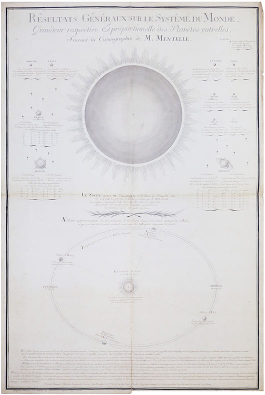
MENTELLE (Edmé) & MÉTOYEN (Jean-Baptiste).
Résultats généraux sur le système du Monde.
1811. 96,5 x 65 cm.
书商的参考编号 : LBW-7446
|
|
|
MENTELLE / CHANLAIRE
carte comparative des divisions anciennes et modernes du territoire actuel de la france.
A Paris chez les auteurs , an VI ( 1798 ) , carte de44 x 34 cm , contours et régions coloriées . Carte très interessante de par sa date et le propos des auteurs.
书商的参考编号 : M16921
|
|
 ?????????
 ?????PDF???
 RSS feed


