|
MILCENT (Philippe-Nicolas).
Veue de Paris du côté de Belleville, dessiné de la maison entre les deux moulins, au dessus de la Courtille, en 1736.
Paris, V.e de F. Chéreau, 1736. 0,34 x 1,02 m.
Bookseller reference : LBW-5901

|
|
|
MILMEISTER Jean
Vianden en cartes postales anciennes/Vianden in alten Ansichten.
Zaltbommel (Pays-Bas), Bibliothèque Européenne, 1984. 21 x 15, sans pagination, 76 illustrations en N/B, reliure d'édition pleine toile, bon état.
Bookseller reference : 83274
|
|
|
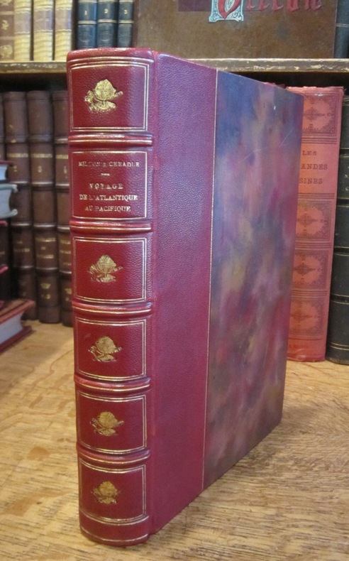
MILTON (Vicomte) et CHEADLE (Dr W. B.)
Voyage de l'Atlantique au Pacifique à travers le Canada, les Montagnes Rocheuses et la Colombie anglaise, par le Vicomte Milton et le Dr W.B. Cheadle. Traduit de l'anglais avec l'autorisation des auteurs par J. Belin-de Launay, et contenant 22 vignettes sur bois et 2 cartes.
Hachette et Cie (Imprimerie Générale de Ch. Lahure), 1866
Bookseller reference : 003178
|
|
|
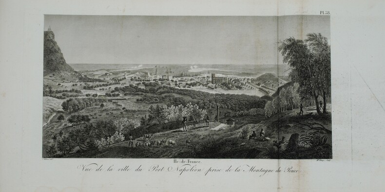
MILBERT (Jacques-Gérard).
Voyage pittoresque à l'Île-de-France, au cap de Bonne-Espérance et à l'île de Ténériffe.
Paris, A. Nepveu, 1812. 2 volumes de texte in-8 (210x130), veau havane marbré, dos lisse orné, pièces de titre et de tomaison de maroquin rouge et tabac, roulette encadrant les plats, tranches mouchetées (reliure de l'époque) ,une coiffe usée, et un atlas in-folio oblong (420x280), demi-veau vert, dos lisse fileté or (reliure de l'époque) ,plats et dos frottés avec manques aux coins , début de fente . Première édition, illustrée de 3 tableaux dont 2 dépliants. L'atlas comprend 45 planches et cartes, dessinées et gravées la plupart par l'auteur ,certaines terminées par Coube, Hulk, Gossard ou Perdoux, (carte de l'île de France, vue de la ville du Port Napoléon, vue du Cap de Bonne-Espérance, etc.). L'ouvrage traite de l'histoire de l'île Maurice, de sa population et de son administration, de géologie et de sciences naturelles. Bon exemplaire. Mouillure très claire marginale à quelques planches, déchirure sans manque à la dernière avec réparation .
Bookseller reference : PHO-1228
|
|
|
MILBERT (Jacques-Gérard).
Voyage pittoresque à l'île-de-France, au cap de Bonne-Espérance et à l'île de Ténériffe, Atlas Seul
Paris, A. Nepveu, 1812. Atlas in-folio oblong (420x280), pleine toile moderne, auteur et titre au dos, rousseurs, cachet de librairie, petite mouillure en début d’ouvrage, déchirures sur 2 planches en marge sans manque. Première édition, l'atlas comprend 45 planches et cartes, dessinées et gravées la plupart par l'auteur, certaines terminées par Coube, Hulk, Gossard ou Perdoux, (vue de la ville du Port Napoléon, vue du Cap de Bonne-Espérance, etc.). L'ouvrage traite de l'histoire de l'île Maurice, de sa population et de son administration, de géologie et de sciences naturelles.
Bookseller reference : PHO-1644
|
|
|
MILTON ; CHEADLE Dr.; BELIN-DE LAUNAY J. (trad.):
Voyage de l'Atlantique au Pacifique à travers le Canada, les Montagnes Rocheuses et la Colombie anglaise.
Paris, Hachette & Cie, 1872. In-12 de [4]-XXXI-[1]-315 pages, pleine percaline verte d'éditeur, 1er plat décoré d'une composition dorée, avec le titre, doré aussi, tout comme sur le dos. Bel exemplaire sans aucune rousseur.
Bookseller reference : 6248

|
|
|
Miles Virginia Weisel; Illustrated with Photographs and with Maps Prepared byBrigadier General W. M. Johnson
UNREGIMENTED GENERAL. A Biography of Nelson A. Miles
Boston MA: Houghton Mifflin Company. VG/FR. 1962. First Printing. Cloth w/DJ. 8vo. 401 pp. Dj is rubbed and frayed along edges . Houghton Mifflin Company hardcover
Bookseller reference : BOOKS298849
|
|
|
Miller G. S.; Drawings & Maps Illustrator
Catalogue of the Mammals of Western Europe Exclusive of Russia in the Collection of the British Museum
British Museum of Natural History 1/1/1912. Hardcover. Very Good. Hardcover. Publishers brown cloth. Gilt spine. Good binding and cover. Shelfwear. Stamps verso of title page. Clean unmarked pages. Ships daily.<br> From the library of Robert H. Gibbs Jr noted American ichthyologist. He was an authority on pelagic and deep-sea fishes. He was a long-standing curator at the Smithsonian Institution National Museum of Natural History as well as an avid conservationist and a member of the American Society of Ichthyologists and Herpetologists for over 30 years. This is an oversized or heavy book that requires additional postage for international delivery outside the US. British Museum of Natural History hardcover
Bookseller reference : 1608010021
|
|
|
Miller G. S. & G. Allen; Drawings & Maps Illustrator
The American Bats of the Genera Myotis and Pizonyx
U. S. Government Printing 1928-01-01. First Edition. Paperback. Very Good. Original gray stiff paper wraps with black lettering on cover and along spine. Binding secure. Contents clean and unmarked; age appropriate toning. 216 pages. Index. Plate; Maps. First Edition. Additional photos available upon request. All items carefully packed to avoid damage from moisture and rough handling. U. S. Government Printing paperback
Bookseller reference : 021534

|
|
|
Miller Helen Hill maps: George Annand
BRIDGE TO ASIA The Greeks in the Eastern Mediterranean
New York NY: Charles Scribner's Sons. G/G. 1967. First Edition. Cloth. 8vo. 256 pp. DJ price-clipped back cover chipped pencilling on TOC page . Charles Scribner's Sons hardcover
Bookseller reference : BOOKS242471
|
|
|
Millis Walter/Bryant Samuel Hanks maps
The Last Phase: Allied Victory in Western Europe
Boston: Houghton Mifflin 1946. 1st printing. Good/Good price clipped dust jacket 1 inch x 3 inch piece missing from top front of dust jacket. xiv 130 p. frontis photos map on endpapers 8vo; Houghton Mifflin hardcover
Bookseller reference : 23853
|
|
|
Millmore, Paul
South Downs Way : National Trail Guide
Light dusty marks to top page edges. No other marks or inscriptions. Very minor creasing to covers, none to spine. Clean bright boards with no bumping to corners. A lovely clean crisp tight copy. The contents appear to be 'as new' and never used. 168pp.

|
|
|
Mills, Anastasia R. (editor)
Fodor's Maine, Vermont, New Hampshire : Country Dining, B&Bs, Antiques and Mountain and Coastal Drives (3rd ed)
No marks or inscriptions. No creasing to covers or to spine. A very clean very tight copy with bright unmarked boards, minor indenting to upper front edge and no bumping to corners. 240pp. Travel guide to the USA's New England - Maine, Vermont, New Hampshire.

|
|
|
Millward, A.E.; Rosenmuller, M. (Appendix); Anderson, M.B.A. (Translator)
Southern Baffin Island: An Account of Exploration, Investigation and Settlement During the Past Fifty Years - with Appendix "The Crossing of Baffin Island to Foxe Basin by Bernard A. Hantzsch in 1910"
130 pages. Printed on glossy stock. Thirty-nine reproductions of black and white photos. Fifteen maps, four of which fold out. Heavily worn. Prior owner's lavishly handwritten details upon first blank leaf. Covers almost loose. Taped repairs to spine. Contains summaries of the work done, 1882-1928, by various expeditions, Church of England missions, the Royal Canadian Mounted Police, Dept. of the Interior and Geological Survey of Canada, in opening up the country, and providing new maps and information. [AB 2751] Book

|
|
|
Milner, Rev. Thomas.
THE GALLERY OF GEOGRAPHY: A PICTORIAL AND DESCRIPTIVE TOUR OF THE WORLD.
Two volumes. pp. xvii, 510; 511-956 + Plus 12 colored folding maps + Five steel engraved plates + Engraved illustrated title page. Numerous woodcut illustrations in the text. 8vo. Worn original full leather bindings. A thorough delight for the Victorian arm chair traveller. This American edition is rather scarce. **PRICE JUST REDUCED! W156
|
|
|
MINISTÈRE des TRAVAUX PUBLICS.
[BARCELONE] Barcelone.
Paris, Auto. Marchadier et Cie, 1883. 295 x 462 mm.
Bookseller reference : LBW-5473

|
|
|
MINISTÈRE des TRAVAUX PUBLICS.
[BOSTON] Boston.
Paris, Auto. Marchadier et Cie, 1884. 295 x 661 mm.
Bookseller reference : LBW-5432

|
|
|
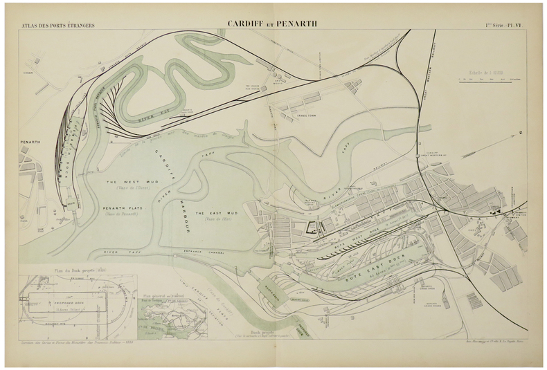
MINISTÈRE des TRAVAUX PUBLICS.
[CARDIFF] Cardiff et Penarth.
Paris, Auto. Marchadier et Cie, 1883. 290 x 462 mm.
Bookseller reference : LBW-5476
|
|
|
MINISTÈRE des TRAVAUX PUBLICS.
[CHARLESTON] Charleston.
Paris, Auto. Marchadier et Cie, 1884. 295 x 472 mm.
Bookseller reference : LBW-5449

|
|
|
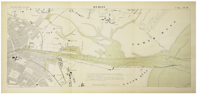
MINISTÈRE des TRAVAUX PUBLICS.
[DUBLIN] Dublin.
Paris, Auto. Marchadier et Cie, 1884. 290 x 651 mm.
Bookseller reference : LBW-5475
|
|
|
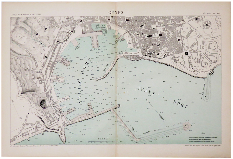
MINISTÈRE des TRAVAUX PUBLICS.
[GÊNES] Gênes.
Paris, Auto. Marchadier et Cie, 1884. 290 x 450 mm.
Bookseller reference : LBW-5472
|
|
|
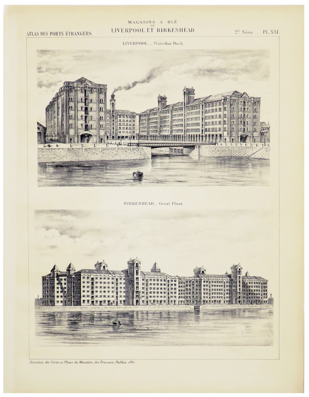
MINISTÈRE des TRAVAUX PUBLICS.
[LIVERPOOL] Magasins à blé de Liverpool et Birkenhead.
Paris, Auto. Marchadier et Cie, 1884. 286 x 209 mm.
Bookseller reference : LBW-5467
|
|
|
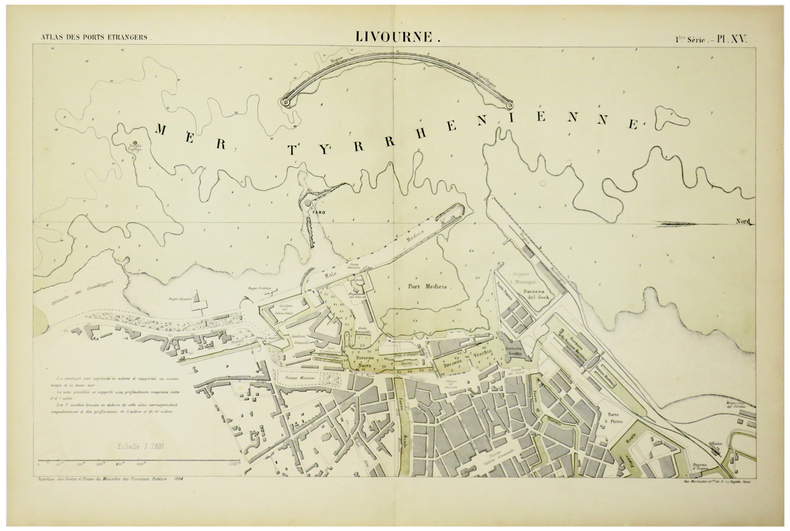
MINISTÈRE des TRAVAUX PUBLICS.
[LIVOURNE] Livourne.
Paris, Auto. Marchadier et Cie, 1884. 285 x 460 mm.
Bookseller reference : LBW-5471
|
|
|
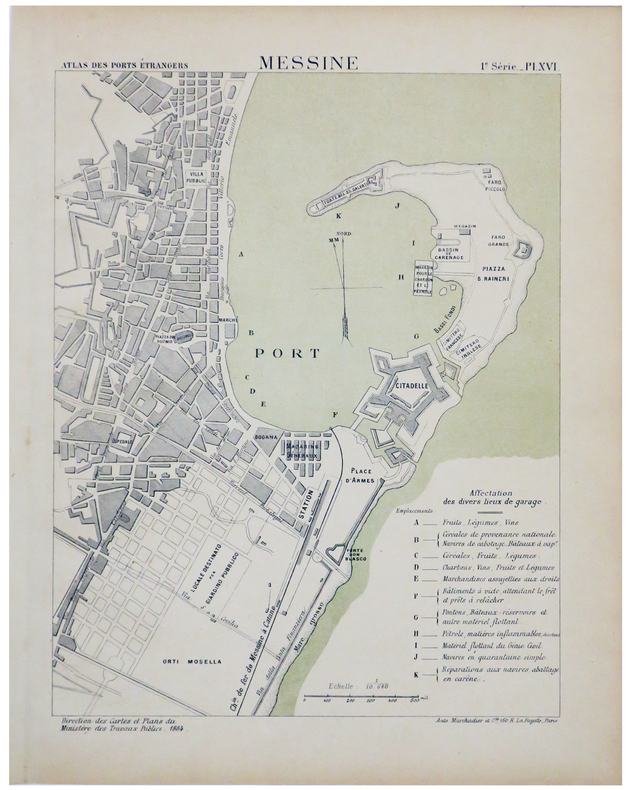
MINISTÈRE des TRAVAUX PUBLICS.
[MESSINE] Messine.
Paris, Auto. Marchadier et Cie, 1884. 285 x 212 mm.
Bookseller reference : LBW-5470
|
|
|
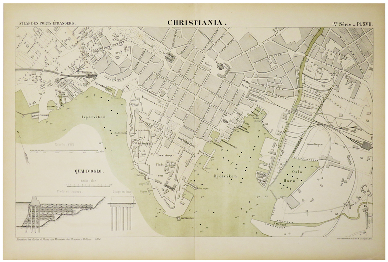
MINISTÈRE des TRAVAUX PUBLICS.
[OSLO] Christiania.
Paris, Auto. Marchadier et Cie, 1884. 285 x 459 mm.
Bookseller reference : LBW-5469
|
|
|
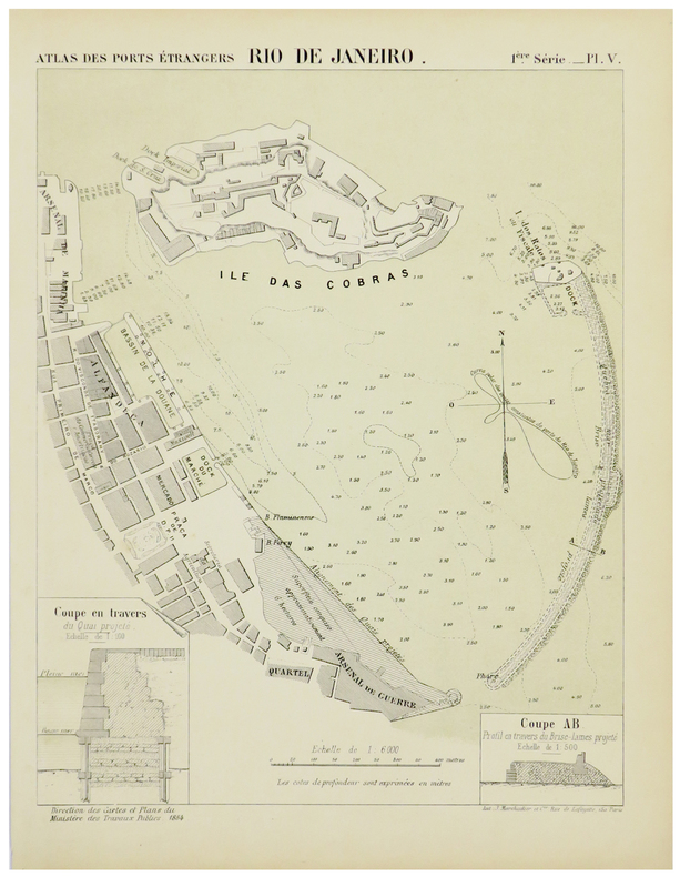
MINISTÈRE des TRAVAUX PUBLICS.
[RIO de JANEIRO] Rio de Janeiro.
Paris, Auto. Marchadier et Cie, 1884. 295 x 225 mm.
Bookseller reference : LBW-5430
|
|
|
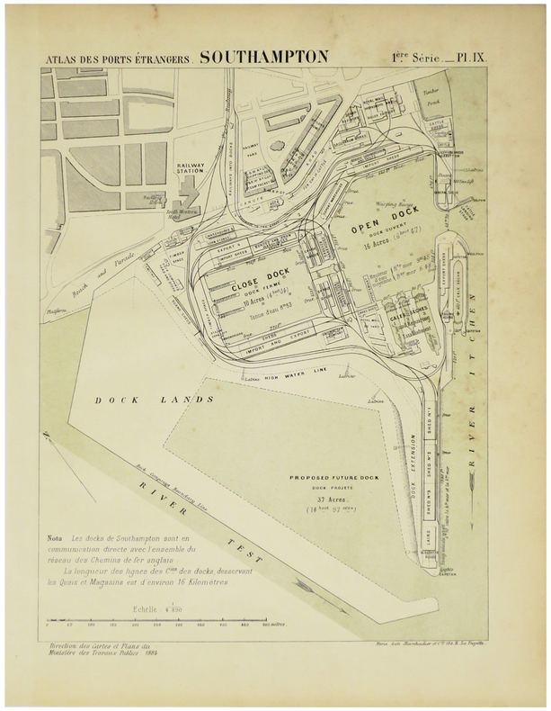
MINISTÈRE des TRAVAUX PUBLICS.
[SOUTHAMPTON] Docks de Southampton.
Paris, Auto. Marchadier et Cie, 1883. 300 x 450 mm.
Bookseller reference : LBW-5466

|
|
|
MINISTÈRE des TRAVAUX PUBLICS.
[SOUTHAMPTON] Southampton.
Paris, Auto. Marchadier et Cie, 1884. 285 x 211 mm.
Bookseller reference : LBW-5474
|
|
|
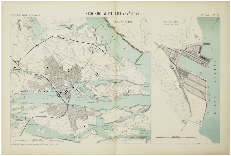
MINISTÈRE des TRAVAUX PUBLICS.
[STOCKHOLM] Stockholm et Lilla-Värtan.
Paris, Auto. Marchadier et Cie, 1883. 285 x 452 mm.
Bookseller reference : LBW-5468
|
|
|
Ministère des colonies
Cadastre, instructions techniques à l'usage du personnel du service du cadastre de la colonie. Ministère des colonies : Carthographie et cadastre.
Bruxelles, Imprimerie Marcel Hayez, 1949. "16 x 24, 124 pp., 36 figures, broché, bon état (couverture très légèrement insolée; cachet d'ex-propriétaire)."
Bookseller reference : 91158
|
|
|
Ministère de l'Intérieur
Carte a 1/100.000. MONTAUBAN
Paris Librairie Hachette et Cie 1892 in 12 (16x10) 1 carte géographique en couleurs, imprimée sur papier, de format : 45 x 57 cm, pliée sous chemise rigide de percaline rouge de l'éditeur, plat supérieur titré. Carte gravée originale avec représentation du relief, et le tracé des routes, chemins vicinaux, et autres. Carte de la France dressée par ordre du Ministre de l'Intérieur au 1/100.000e, feuille XV-32 MONTAUBAN. Bel exemplaire
Bookseller reference : 48669
|
|
|
Ministère de l'Intérieur
Carte a 1/100.000. LACAUNE (Tarn)
Paris Librairie Hachette et Cie 1892 in 12 (16x10) 1 carte routière en couleurs, imprimée sur papier, de format : 45 x 57 cm, pliée sous chemise rigide de percaline rouge de l'éditeur, plat supérieur titré. Carte gravée originale avec représentation du relief, et le tracé des routes, chemins vicinaux, et autres. Carte de la France dressée par ordre du Ministre de l'Intérieur a 1/100.000e, feuille XVII-33 LACAUNE (Tarn). Bel exemplaire ( Photographies sur demande / We can send pictures of this print on simple request )
Bookseller reference : 48671
|
|
|
Ministère de l'Intérieur
Carte a 1/100.000. PERLES (Ariège)
Paris Librairie Hachette et Cie 1893 in 12 (16x10) 1 carte géographique en couleurs, imprimée sur papier, de format : 45 x 57 cm, pliée sous chemise rigide de percaline rouge de l'éditeur, plat supérieur titré. Carte gravée originale avec représentation du relief, et le tracé des routes, chemins vicinaux, et autres. Carte de la France dressée par ordre du Ministre de l'Intérieur a 1/100.000e, feuille XV-38 PERLES (Ariège). Bel exemplaire ( Photographies sur demande / We can send pictures of this print on simple request )
Bookseller reference : 48672
|
|
|
Ministère de l'Intérieur
Carte a 1/100.000. XVIII-28 SAINT-FLOUR (Cantal)
Paris Librairie Hachette et Cie 1891 in 12 (16x10) 1 carte géographique en couleurs, imprimée sur papier, de format : 45 x 57 cm, pliée sous chemise rigide de percaline rouge de l'éditeur, plat supérieur titré. Carte gravée originale avec représentation du relief, et le tracé des routes, chemins vicinaux, et autres. Carte de la France dressée par ordre du Ministre de l'Intérieur a 1/100.000e, feuille XVIII-28 SAINT-FLOUR (Cantal). Bel exemplaire ( Photographies sur demande / We can send pictures of this print on simple request )
Bookseller reference : 48674
|
|
|
Ministère de l'Intérieur
Carte a 1/100.000. feuille XVII-36 CARCASSONNE (Aude)
Paris Librairie Hachette et Cie 1892 in 12 (16x10) 1 carte géographique en couleurs, imprimée sur papier, de format : 45 x 57 cm, pliée sous chemise rigide de percaline rouge de l'éditeur, plat supérieur titré. Carte gravée originale avec représentation du relief, et le tracé des routes, chemins vicinaux, et autres. Carte de la France dressée par ordre du Ministre de l'Intérieur a 1/100.000e, feuille XVII-36 CARCASSONNE (Aude). Bel exemplaire ( Photographies sur demande / We can send pictures of this print on simple request )
Bookseller reference : 48675
|
|
|
Ministère de l'Intérieur
Carte a 1/100.000. feuille XVIII-39 BANYULS SUR MER (Pyrénées orientales)
Paris Librairie Hachette et Cie 1893 in 12 (16x10) 1 carte géographique en couleurs, imprimée sur papier, de format : 45 x 57 cm, pliée sous chemise rigide de percaline rouge de l'éditeur, plat supérieur titré. Carte gravée originale avec représentation du relief, et le tracé des routes, chemins vicinaux, et autres. Carte de la France dressée par ordre du Ministre de l'Intérieur au 1/100.000e, feuille XVIII-39 BANYULS SUR MER (Pyrénées orientales). Bel exemplaire ( Photographies sur demande / We can send pictures of this print on simple request )
Bookseller reference : 48676
|
|
|
Ministère de l'Intérieur
Carte a 1/100.000. feuille XVIII-37 RIVESALTES (Pyrénées orientales)
Paris Librairie Hachette et Cie 1891 in 12 (16x10) 1 carte géographique en couleurs, imprimée sur papier, de format : 45 x 57 cm, pliée sous chemise rigide de percaline rouge de l'éditeur, plat supérieur titré. Carte gravée originale avec représentation du relief, et le tracé des routes, chemins vicinaux, et autres. Carte de la France dressée par ordre du Ministre de l'Intérieur a 1/100.000e, feuille XVIII-37 RIVESALTES (Pyrénées orientales). Bel exemplaire ( Photographies sur demande / We can send pictures of this print on simple request )
Bookseller reference : 48681
|
|
|
Ministère de l'Intérieur
Carte a 1/100.000. feuille XVII-31 RODEZ (Aveyron)
Paris Librairie Hachette et Cie 1891 in 12 (16x10) 1 carte géographique en couleurs, imprimée sur papier, de format : 45 x 57 cm, pliée sous chemise rigide de percaline rouge de l'éditeur, plat supérieur titré. Carte gravée originale avec représentation du relief, et le tracé des routes, chemins vicinaux, et autres. Carte de la France dressée par ordre du Ministre de l'Intérieur a 1/100.000e, feuille XVII-31 RODEZ (Aveyron). Bel exemplaire ( Photographies sur demande / We can send pictures of this print on simple request )
Bookseller reference : 48682
|
|
|
Ministère de l'Intérieur
Carte a 1/100.000. feuille XVIII-33 SAINT AFFRIQUE (Aveyron)
Paris Librairie Hachette et Cie 1898 in 12 (16x10) 1 carte géographique en couleurs, imprimée sur papier, de format : 45 x 57 cm, pliée sous chemise rigide de percaline rouge de l'éditeur, plat supérieur titré. Carte gravée originale avec représentation du relief, et le tracé des routes, chemins vicinaux, et autres. Carte de la France dressée par ordre du Ministre de l'Intérieur a 1/100.000e, feuille XVIII-33 SAINT AFFRIQUE (Aveyron). Bel exemplaire ( Photographies sur demande / We can send pictures of this print on simple request )
Bookseller reference : 48683
|
|
|
Ministère de l'Intérieur
Carte a 1/100.000. feuille XVI-34 CASTRES (Tarn
Paris Librairie Hachette et Cie 1893 in 12 (16x10) 1 carte routière en couleurs, imprimée sur papier, de format : 45 x 57 cm, pliée sous chemise rigide de percaline rouge de l'éditeur, plat supérieur titré. Carte gravée originale avec représentation du relief, et le tracé des routes, chemins vicinaux, et autres. Carte de la France dressée par ordre du Ministre de l'Intérieur a 1/100.000e, feuille XVI-34 CASTRES (Tarn). Bel exemplaire ( Photographies sur demande / We can send pictures of this print on simple request )
Bookseller reference : 48684
|
|
|
Ministère de l'Intérieur
Carte a 1/100.000. feuille XVIII-38 PERPIGNAN (Pyrénées orientales)
Paris Librairie Hachette et Cie 1892 in 12 (16x10) 1 carte géographique en couleurs, imprimée sur papier, de format : 45 x 57 cm, pliée sous chemise rigide de percaline rouge de l'éditeur, plat supérieur titré. Carte gravée originale avec représentation du relief, et le tracé des routes, chemins vicinaux, et autres. Carte de la France dressée par ordre du Ministre de l'Intérieur a 1/100.000e, feuille XVIII-38 PERPIGNAN (Pyrénées orientales). Bel exemplaire ( Photographies sur demande / We can send pictures of this print on simple request )
Bookseller reference : 48685
|
|
|
Ministère de l'Intérieur
Carte a 1/100.000. feuille XV-36 PAMIERS (Ariège)
Paris Librairie Hachette et Cie 1893 in 12 (16x10) 1 carte géographique en couleurs, imprimée sur papier, de format : 45 x 57 cm, pliée sous chemise rigide de percaline rouge de l'éditeur, plat supérieur titré. Carte gravée originale avec représentation du relief, et le tracé des routes, chemins vicinaux, et autres. Carte de la France dressée par ordre du Ministre de l'Intérieur a 1/100.000e, feuille XV-36 PAMIERS (Ariège). Bel exemplaire ( Photographies sur demande / We can send pictures of this print on simple request )
Bookseller reference : 48687
|
|
|
Ministère de l'Intérieur
Carte a 1/100.000. feuille XVII-38 PRADES (Pyrénées orientales)
Paris Librairie Hachette et Cie 1898 in 12 (16x10) 1 carte géographique en couleurs, imprimée sur papier, de format : 45 x 57 cm, pliée sous chemise rigide de percaline rouge de l'éditeur, plat supérieur titré. Carte gravée originale avec représentation du relief, et le tracé des routes, chemins vicinaux, et autres. Carte de la France dressée par ordre du Ministre de l'Intérieur a 1/100.000e, feuille XVII-38 PRADES (Pyrénées orientales). Bel exemplaire ( Photographies sur demande / We can send pictures of this print on simple request )
Bookseller reference : 48688
|
|
|
Ministère de l'Intérieur
Carte a 1/100.000. feuille XXII-34 SALON (DE PROVENCE) (Bouches du Rhône)
Paris Librairie Hachette et Cie 1890 in 12 (16x10) 1 carte géographique en couleurs, imprimée sur papier, de format : 45 x 57 cm, pliée sous chemise rigide de percaline rouge de l'éditeur, plat supérieur titré. Carte gravée originale avec représentation du relief, et le tracé des routes, chemins vicinaux, et autres. Carte de la France dressée par ordre du Ministre de l'Intérieur a 1/100.000e, feuille XXII-34 SALON (DE PROVENCE) (Bouches du Rhône). Bel exemplaire ( Photographies sur demande / We can send pictures of this print on simple request )
Bookseller reference : 48689
|
|
|
Ministère de l'Intérieur
Carte a 1/100.000. feuille XVII-38 PRADES (Pyrénées orientales)
Paris Librairie Hachette et Cie 1893 in 12 (16x10) 1 carte géographique en couleurs, imprimée sur papier, de format : 45 x 57 cm, pliée sous chemise rigide de percaline rouge de l'éditeur, plat supérieur titré. Carte gravée originale avec représentation du relief, et le tracé des routes, chemins vicinaux, et autres. Carte de la France dressée par ordre du Ministre de l'Intérieur a 1/100.000e, feuille XVII-38 PRADES (Pyrénées orientales). Bel exemplaire ( Photographies sur demande / We can send pictures of this print on simple request )
Bookseller reference : 48690
|
|
|
Ministère de l'Intérieur
Carte a 1/100.000. feuille XV-37 FOIX (Ariège)
Paris Librairie Hachette et Cie 1893 in 12 (16x10) 1 carte géographique en couleurs, imprimée sur papier, de format : 45 x 57 cm, pliée sous chemise rigide de percaline rouge de l'éditeur, plat supérieur titré. Carte gravée originale avec représentation du relief, et le tracé des routes, chemins vicinaux, et autres. Carte de la France dressée par ordre du Ministre de l'Intérieur a 1/100.000e, feuille XV-37 FOIX (Ariège). Bel exemplaire ( Photographies sur demande / We can send pictures of this print on simple request )
Bookseller reference : 48691
|
|
|
Ministère de l'Intérieur
Carte a 1/100.000. feuille XVI-37 LAVELANET (Aude)
Paris Librairie Hachette et Cie 1893 in 12 (16x10) 1 carte géographique en couleurs, imprimée sur papier, de format : 45 x 57 cm, pliée sous chemise rigide de percaline rouge de l'éditeur, plat supérieur titré. Carte gravée originale avec représentation du relief, et le tracé des routes, chemins vicinaux, et autres. Carte de la France dressée par ordre du Ministre de l'Intérieur a 1/100.000e, feuille XVI-37 LAVELANET (Aude). Bel exemplaire ( Photographies sur demande / We can send pictures of this print on simple request )
Bookseller reference : 48692
|
|
|
Ministère de l'Intérieur
Carte a 1/100.000. feuille XV-34 TOULOUSE (Haute-Garonne)
Paris Librairie Hachette et Cie 1892 in 12 (16x10) 1 carte routière en couleurs, imprimée sur papier, de format : 45 x 57 cm, pliée sous chemise rigide de percaline rouge de l'éditeur, plat supérieur titré. Carte gravée originale avec représentation du relief, et le tracé des routes, chemins vicinaux, et autres. Carte de la France dressée par ordre du Ministre de l'Intérieur a 1/100.000e, feuille XV-34 TOULOUSE (Haute-Garonne). Bel exemplaire ( Photographies sur demande / We can send pictures of this print on simple request )
Bookseller reference : 48694
|
|
|
Ministère de l'Intérieur
Carte a 1/100.000. feuille XVII-29 AURILLAC (Cantal)
Paris Librairie Hachette et Cie 1891 in 12 (16x10) 1 carte géographique en couleurs, imprimée sur papier, de format : 45 x 57 cm, pliée sous chemise rigide de percaline rouge de l'éditeur, plat supérieur titré. Carte gravée originale avec représentation du relief, et le tracé des routes, chemins vicinaux, et autres. Carte de la France dressée par ordre du Ministre de l'Intérieur a 1/100.000e, feuille XVII-29 AURILLAC (Cantal). Bel exemplaire ( Photographies sur demande / We can send pictures of this print on simple request )
Bookseller reference : 48695
|
|
|
Ministère de l'Intérieur
Carte a 1/100.000. feuille XVIII-34 LODÈVE (Hérault)
Paris Librairie Hachette et Cie 1892 in 12 (16x10) 1 carte géographique en couleurs, imprimée sur papier, de format : 45 x 57 cm, pliée sous chemise rigide de percaline rouge de l'éditeur, plat supérieur titré. Carte gravée originale avec représentation du relief, et le tracé des routes, chemins vicinaux, et autres. Carte de la France dressée par ordre du Ministre de l'Intérieur a 1/100.000e, feuille XVIII-34 LODÈVE (Hérault). Bel exemplaire ( Photographies sur demande / We can send pictures of this print on simple request )
Bookseller reference : 48696
|
|
 Receive by email
 Download as PDF document
 RSS feed


