|
Michelin Travel Publications
Vannes la Baule Angers (Michelin Maps)
Travel House Media 2001 24 4x0 8x10 6cm. 2001. map.
Bookseller reference : 500085864

|
|
|
Michelin Travel Publications
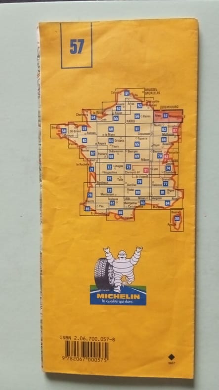
Verdun-Metz-Wissembourg (Michelin Maps)
Michelin Maps 1997 10 6x0 6x24 6cm. 1997. Broché.
Bookseller reference : 500179375
|
|
|
Michelin Travel Publications Pneu Michelin
Michelin Karten Bl.517 : Bretagne (Michelin Maps)
Travel House Media 2003 11x1x24 6cm. 2003. map.
Bookseller reference : 500085871

|
|
|
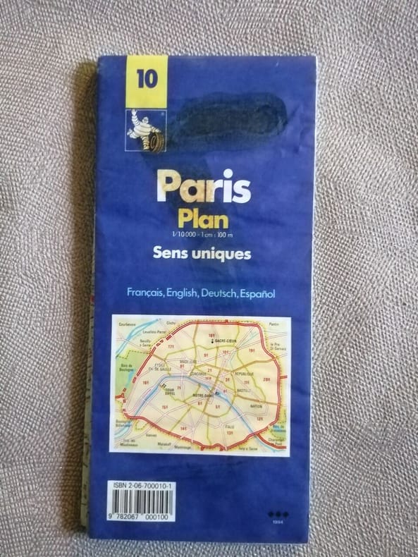
Michelin Travel Publications Pneu Michelin
Michelin Paris Pocket Atlas (Michelin Maps)
Michelin Maps 1989 24 2x0 6x11cm. 1989. map.
Bookseller reference : 500225574
|
|
|
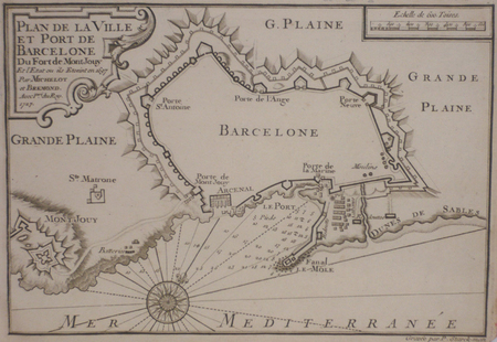
MICHELOT & BREMOND;
[BARCELONE] Plan de la ville et port de Barcelone du fort de Mont Jouy.
1727 174 x 254 mm.
Bookseller reference : LBW024f1
|
|
|
MICHELOT & BREMOND;
[CATALOGNE/CADAQUES] Plan du port de Cadequié en Catalogne.
1727 173 x 251 mm.
Bookseller reference : LBW024f3
|
|
|
MICHELOT & BREMOND;
[CATALOGNE/ROSES] Plan de la baye et citadelle de Rose et de Tourrille.
1727 172 x 251 mm.
Bookseller reference : LBW024f2
|
|
|
MICHELOT & BREMOND;
[ELBE] Plan de Porto Ferraro en l'isle de l'Elbe.
1730 178 x 255 mm.
Bookseller reference : LBW002a2
|
|
|
MICHELOT & BREMOND;
[MESSINE] Partie de la ville et port de Messine.
1727 173 x 250 mm.
Bookseller reference : LBW00265
|
|
|
MICHELOT & BREMOND;
[NAPLES] Plan du golfe de Naples.
1727 174 x 250 mm.
Bookseller reference : LBW0026c

|
|
|
MICHELOT & BRÉMOND.
[PALERME] Plan de la ville, port et rades de Palerme.
[1730]. 175 x 250 mm.
Bookseller reference : LBW00268
|
|
|
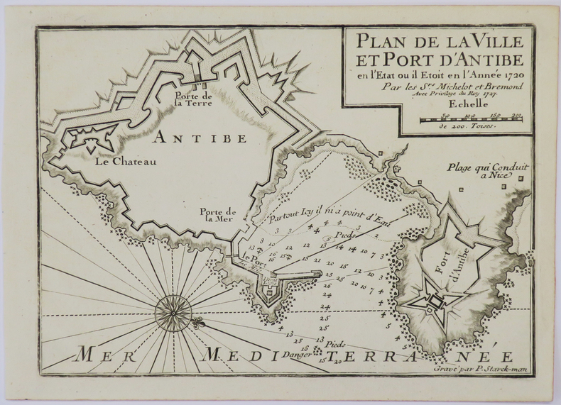
MICHELOT (Henri) & BREMOND (Laurent).
[ANTIBES] Plan de la ville et port d'Antibe en l'état où il étoit en l'année 1720.
1727. 177 x 250 mm.
Bookseller reference : LBW-4932
|
|
|
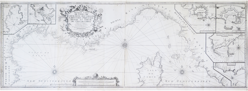
MICHELOT (Henri) & BRÉMOND (Laurent).
Nouvelle carte de côtes de Catalogne, Roussillon, Languedoc, Provence, d'Italie, et partie de l'isle de Corce.
Marseille, Laurent Brémond, 1718. En deux feuilles jointes formant une carte de 46,5 x 136,5 cm.
Bookseller reference : LBW-7946
|
|
|
MICHELOTTI, Giuseppe Teresio.
Ensayo Hydrografico do Piemonte. Por José Threzio Michelotti, antigo professor de mathematica na Universidade de Torim. Traduzido pello Padre Francisco Furtado de Mendonça. Oferescido a S.A.R. o Principe de Brasil, Regente de Portogal.
Roma, por Antonio Fulgoni, 1803. 4to. mayor; XV pp., 118 pp. y seis láminas plegadas, grabadas por Giovanni Battista Cipriani, una de ellas un gran mapa del Piamonte diseñado por Andrea Cattaneo. Encuadernación moderna en tela. Giuseppe Teresio Michelotti, de la saga turinesa de los Michelotti, ingenieros y arquitectos especialistas en Hidráulica, de renombre universal, era hermano de Ignazio Maria Lorenzo Michelotti (1764-1846) e hijos ambos de Francesco Domenico Michelotti (1710-1787). El último de los Michelotti, Giovanni, fue ya en nuestros dias uno de los grandes diseñadores de automóviles en la FIAT de Turín. La presente obra sobre el Piamonte y su hidrografía podría considerarse el mejor estudio existente sobre cuatro ríos y una ciudad, ó bien: una ciudad y cuatro rios.

|
|
|
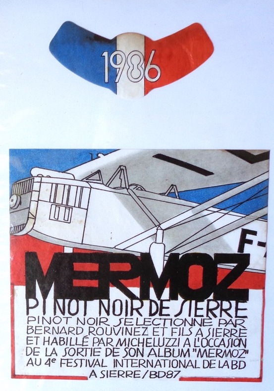
Micheluzzi:
Mermoz. Pinot noir de Sierre.
Etiquette de vin et bandeau, pinot noir sélectionné par Bernard Rouvinez.
Bookseller reference : 1900
|
|
|
Michler Gunther
Grosser illustrierter Weltatlas. Der Atlas f�r die ganze Familie
Berlin: Corvus Verlag 1977 Well illustrated world atlas. 300p. index. Large format heavy volume 1700gr Size: 35cm X.25cm.x 3. Hardcover. Near Fine/Near Fine. Corvus Verlag hardcover
Bookseller reference : 31779
|
|
|
Middleton Harry J./Mossman BC. maps B. C.
The Compact History of the Korean War
NY: Hawthorn Books 1966. 2nd printing. VG/no dust jacket. 256 p. maps appendix biblio index 8vo; Hawthorn Books hardcover
Bookseller reference : 21077
|
|
|
MIDTJYLLAND - MERCATOR, G.(GERHARD).
Iutia Septentrionalis.
(Amsterdam, 1595-1623). 29x40 cm. Kobberstukket kort over Nørrejylland, egnene omkring Limfjorden, vendsyssel i nord og til Horsens i syd samt Samsø. Samtidig håndkolorering. Bagsiden med latinsk tekst. Barokkartouche.
Bookseller reference : 47336
|
|
|
MIDTJYLLAND - MERCATOR, G.(GERHARD).
Iutia Septentrionalis.
(Amsterdam, 1595-1623). 29x40 cm. Kobberstukket kort over Nørrejylland, egnene omkring Limfjorden, vendsyssel i nord og til Horsens i syd samt Samsø. Samtidig håndkolorering. Bagsiden med latinsk tekst. Barokkartouche.
|
|
|
Midwest Plan Service
Private Water Systems Handbook
Book is in excellent condition. Binding is solid and square, covers have sharp corners, exterior shows no blemishes, text/interior is clean and free of marking of any kind. 72 pages with charts, graphs, tables, maps, mechanical drawings. Sections include: Water quantity, Water sources ( ground water, surface, wells, catchments and cisterns, -- roof cisterns --, ponds, springs) Pumps, (motors, special pumps -- rams windmills booster ) Pressure tanks and cotntrols, Piping, Water treatment (deteerfmining water quality, treatments and equipment -- disinfection , chlorine, heat, ultraviolet light, iodine), Chlorination, (shock, continuous, solution injection, management, residual, iron removal, nitrate and sulfate removal, softening, acid water) etc.

|
|
|
Miers Earl Schenck 1910 1972. book design John J. Walket Jr; maps and illustrations Richard J. Stinely
Blood of freedom : the story of Jamestown Williamsburg and Yorktown. Williamsburg in America series ; 3
Williamsburg Va. Colonial Williamsburg; distributed by Holt New York 1958. 1958. Good. 179 pp. illustrated 21 cm. ; LCCN: 58-13521 ; LC: F234.W7; Dewey: 975.542 ; OCLC: 478924 ; green faux leather boards with lettering and designs in gold ; possible waterstain on back cover not readily apparent ; slight wear to bottom of covers ; G Williamsburg, Va., Colonial Williamsburg; distributed by Holt, New York, 1958. hardcover
Bookseller reference : 4559

|
|
|
Miers, Richenda
Cumbria : County Companion
No marks or inscriptions. No creasing to covers, faint crease to spine. A very clean extremely tight copy with bright unmarked boards and no bumping to corners. 211pp. Complete guide to the county including detailed maps, town directory, leisure A-Z.

|
|
|
MIGNON
"1 CARTE POSTALE COULEURS, TIMBREE ET OBLITEREE ""A l'ombre des grands bois sous le ciel étoilé - Nous trouverons un lit de Fougère et de mousse"" de dimension 9 Cm X 14 Cm environ."
NON PRECISE. XXe SIECLE. In-12. En feuillets. Bon état, Couv. convenable, Dos satisfaisant, Intérieur frais. 1 CARTE POSTALE EN COULEURS de dimension 9 Cm X 14 Cm environ. Annotations au dos en date du 20.X.08.. . . . Classification Dewey : 741.68-Illustrations des cartes postales
Bookseller reference : R320071487
|
|
|
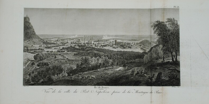
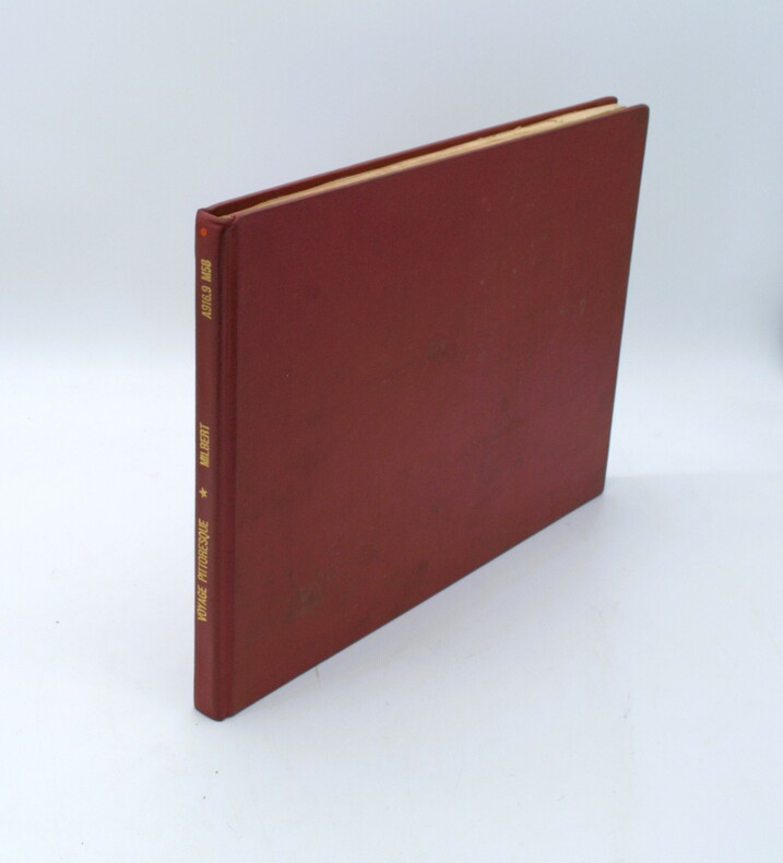
MILBERT (Jacques-Gérard).
Voyage pittoresque à l'Île-de-France, au cap de Bonne-Espérance et à l'île de Ténériffe.
Paris, A. Nepveu, 1812. 2 volumes de texte in-8 (210x130), veau havane marbré, dos lisse orné, pièces de titre et de tomaison de maroquin rouge et tabac, roulette encadrant les plats, tranches mouchetées (reliure de l'époque) ,une coiffe usée, et un atlas in-folio oblong (420x280), demi-veau vert, dos lisse fileté or (reliure de l'époque) ,plats et dos frottés avec manques aux coins , début de fente . Première édition, illustrée de 3 tableaux dont 2 dépliants. L'atlas comprend 45 planches et cartes, dessinées et gravées la plupart par l'auteur ,certaines terminées par Coube, Hulk, Gossard ou Perdoux, (carte de l'île de France, vue de la ville du Port Napoléon, vue du Cap de Bonne-Espérance, etc.). L'ouvrage traite de l'histoire de l'île Maurice, de sa population et de son administration, de géologie et de sciences naturelles. Bon exemplaire. Mouillure très claire marginale à quelques planches, déchirure sans manque à la dernière avec réparation .
Bookseller reference : PHO-1228
|
|
|
MILBERT (Jacques-Gérard).
Voyage pittoresque à l'île-de-France, au cap de Bonne-Espérance et à l'île de Ténériffe, Atlas Seul
Paris, A. Nepveu, 1812. Atlas in-folio oblong (420x280), pleine toile moderne, auteur et titre au dos, rousseurs, cachet de librairie, petite mouillure en début d’ouvrage, déchirures sur 2 planches en marge sans manque. Première édition, l'atlas comprend 45 planches et cartes, dessinées et gravées la plupart par l'auteur, certaines terminées par Coube, Hulk, Gossard ou Perdoux, (vue de la ville du Port Napoléon, vue du Cap de Bonne-Espérance, etc.). L'ouvrage traite de l'histoire de l'île Maurice, de sa population et de son administration, de géologie et de sciences naturelles.
Bookseller reference : PHO-1644
|
|
|
MILCENT (Philippe-Nicolas).
Veue de Paris du côté de Belleville, dessiné de la maison entre les deux moulins, au dessus de la Courtille, en 1736.
Paris, V.e de F. Chéreau, 1736. 0,34 x 1,02 m.
Bookseller reference : LBW-5901

|
|
|
Miles Virginia Weisel; Illustrated with Photographs and with Maps Prepared byBrigadier General W. M. Johnson
UNREGIMENTED GENERAL. A Biography of Nelson A. Miles
Boston MA: Houghton Mifflin Company. VG/FR. 1962. First Printing. Cloth w/DJ. 8vo. 401 pp. Dj is rubbed and frayed along edges . Houghton Mifflin Company hardcover
Bookseller reference : BOOKS298849
|
|
|
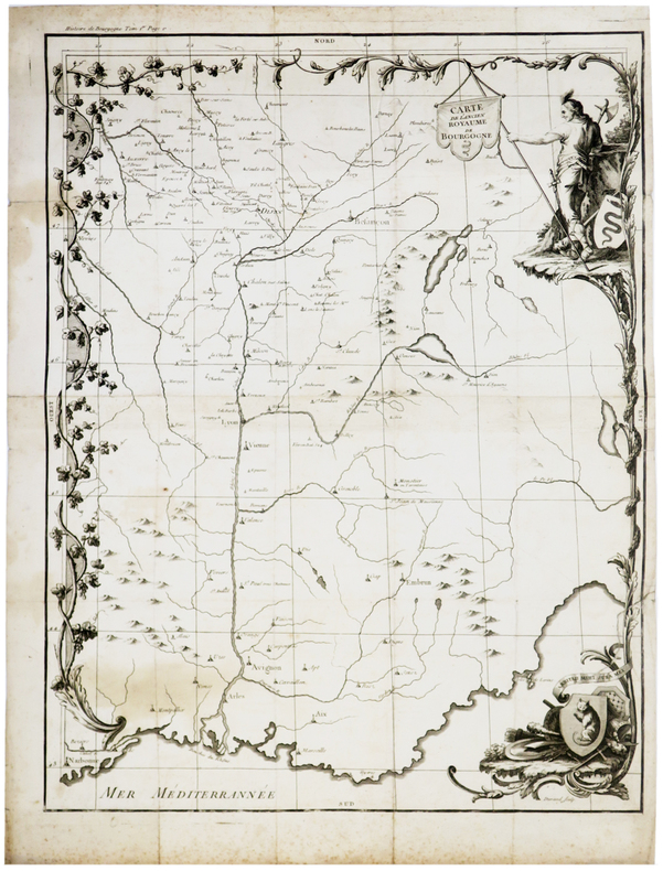
MILLE (Antoine Etienne).
[BOURGOGNE] Carte de l'ancien royaume de Bourgogne.
Dijon, 1771. 544 x 417 mm.
Bookseller reference : LBW-5165
|
|
|
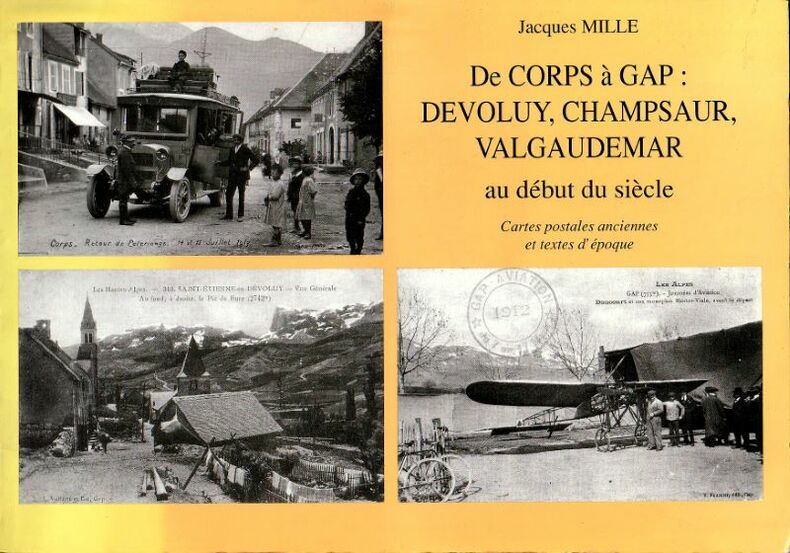
Mille Jacques
De Corps à Gap : Devoluy, Champsaur, Valgaudemar au début du siècle - Cartes postales anciennes et textes d'époque.
A.E In-4°, broché, format " à l'Italienne" format judicieusement choisi pour le montages des cartes postales verticales et horizontales ,147 pages, bel ensemble très richement documenté et contenant de nombreuses reproduction de cartes postales en noir et couleur. Bel exemplaire.
Bookseller reference : 7508
|
|
|
MILLE Jacques / CHATELON André.
Les Hautes-Alpes. Cartes géographiques anciennes ( XV ème - mi XIX ème siècle ).
2011 gap 2011 1 in 8 oblong reliure cartonnée éditeur illustrée. J + 330 pages extrait de l'introduction des auteurs : si les cartes sont aujourd'hui familières , démocratisées et banalisées sur les présentoirs des libraires , il n'en fut pas toujours ainsi.Réservées aux Grands ou aux Militaitres , elles furent souvent " secret défense " ou , si commercialisées , chèrement vendues à une élite privilégiée.Ce livre veut mettre à la portée de tous ces cartes d'autrefois devenues rares aujourd'hui ou seulement visibles en archives ou bibliothèques publiques . Cette plongée dans le passé sera l'occasion de voir comment le territoire des Hautes-Alpes a été représenté , de façon de plus en plus détaillé , au fil des siècles et jusqu'au milieu du XIX ème siècle. Chacun pourra ainsi " découvrir " , au gré de sa lecture , le village , la ville , la région qui lui sont chers ou familiers , tels que les percevaient et les représentaient sur les cartes les hommes d'autrefois.
Bookseller reference : 1619
|
|
|
Miller G. S.; Drawings & Maps Illustrator
Catalogue of the Mammals of Western Europe Exclusive of Russia in the Collection of the British Museum
British Museum of Natural History 1/1/1912. Hardcover. Very Good. Hardcover. Publishers brown cloth. Gilt spine. Good binding and cover. Shelfwear. Stamps verso of title page. Clean unmarked pages. Ships daily.<br> From the library of Robert H. Gibbs Jr noted American ichthyologist. He was an authority on pelagic and deep-sea fishes. He was a long-standing curator at the Smithsonian Institution National Museum of Natural History as well as an avid conservationist and a member of the American Society of Ichthyologists and Herpetologists for over 30 years. This is an oversized or heavy book that requires additional postage for international delivery outside the US. British Museum of Natural History hardcover
Bookseller reference : 1608010021
|
|
|
Miller G. S. & G. Allen; Drawings & Maps Illustrator
The American Bats of the Genera Myotis and Pizonyx
U. S. Government Printing 1928-01-01. First Edition. Paperback. Very Good. Original gray stiff paper wraps with black lettering on cover and along spine. Binding secure. Contents clean and unmarked; age appropriate toning. 216 pages. Index. Plate; Maps. First Edition. Additional photos available upon request. All items carefully packed to avoid damage from moisture and rough handling. U. S. Government Printing paperback
Bookseller reference : 021534

|
|
|
Miller Helen Hill maps: George Annand
BRIDGE TO ASIA The Greeks in the Eastern Mediterranean
New York NY: Charles Scribner's Sons. G/G. 1967. First Edition. Cloth. 8vo. 256 pp. DJ price-clipped back cover chipped pencilling on TOC page . Charles Scribner's Sons hardcover
Bookseller reference : BOOKS242471
|
|
|
MILLET E.
Le département de la Marne
in 8 carré cartonné,dos pincé,premier plat illustré avec titre.92 pages sur papier couché,couverture et dessins de M.LECLUSE.2 cartes en couleurs,39 figures et cartes en noir,100 photographies,Les éditions Lorraines Librairie Frémont,Verdun ,sans date.
Bookseller reference : 4856
|
|
|
Millis Walter/Bryant Samuel Hanks maps
The Last Phase: Allied Victory in Western Europe
Boston: Houghton Mifflin 1946. 1st printing. Good/Good price clipped dust jacket 1 inch x 3 inch piece missing from top front of dust jacket. xiv 130 p. frontis photos map on endpapers 8vo; Houghton Mifflin hardcover
Bookseller reference : 23853
|
|
|
Millmore, Paul
South Downs Way : National Trail Guide
Light dusty marks to top page edges. No other marks or inscriptions. Very minor creasing to covers, none to spine. Clean bright boards with no bumping to corners. A lovely clean crisp tight copy. The contents appear to be 'as new' and never used. 168pp.

|
|
|
Mills, Anastasia R. (editor)
Fodor's Maine, Vermont, New Hampshire : Country Dining, B&Bs, Antiques and Mountain and Coastal Drives (3rd ed)
No marks or inscriptions. No creasing to covers or to spine. A very clean very tight copy with bright unmarked boards, minor indenting to upper front edge and no bumping to corners. 240pp. Travel guide to the USA's New England - Maine, Vermont, New Hampshire.

|
|
|
Millward, A.E.; Rosenmuller, M. (Appendix); Anderson, M.B.A. (Translator)
Southern Baffin Island: An Account of Exploration, Investigation and Settlement During the Past Fifty Years - with Appendix "The Crossing of Baffin Island to Foxe Basin by Bernard A. Hantzsch in 1910"
130 pages. Printed on glossy stock. Thirty-nine reproductions of black and white photos. Fifteen maps, four of which fold out. Heavily worn. Prior owner's lavishly handwritten details upon first blank leaf. Covers almost loose. Taped repairs to spine. Contains summaries of the work done, 1882-1928, by various expeditions, Church of England missions, the Royal Canadian Mounted Police, Dept. of the Interior and Geological Survey of Canada, in opening up the country, and providing new maps and information. [AB 2751] Book

|
|
|
MILMEISTER Jean
Vianden en cartes postales anciennes/Vianden in alten Ansichten.
Zaltbommel (Pays-Bas), Bibliothèque Européenne, 1984. 21 x 15, sans pagination, 76 illustrations en N/B, reliure d'édition pleine toile, bon état.
Bookseller reference : 83274
|
|
|
Milner, Rev. Thomas.
THE GALLERY OF GEOGRAPHY: A PICTORIAL AND DESCRIPTIVE TOUR OF THE WORLD.
Two volumes. pp. xvii, 510; 511-956 + Plus 12 colored folding maps + Five steel engraved plates + Engraved illustrated title page. Numerous woodcut illustrations in the text. 8vo. Worn original full leather bindings. A thorough delight for the Victorian arm chair traveller. This American edition is rather scarce. **PRICE JUST REDUCED! W156
|
|
|
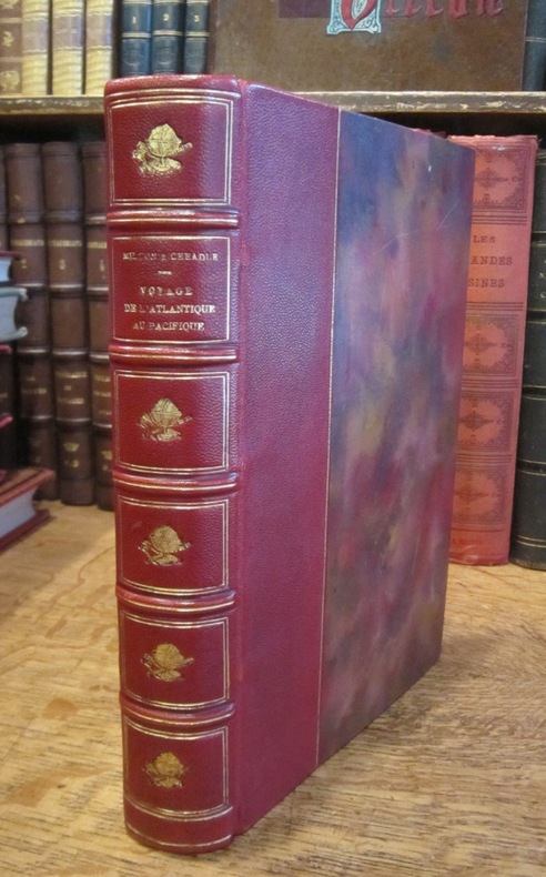
MILTON (Vicomte) et CHEADLE (Dr W. B.)
Voyage de l'Atlantique au Pacifique à travers le Canada, les Montagnes Rocheuses et la Colombie anglaise, par le Vicomte Milton et le Dr W.B. Cheadle. Traduit de l'anglais avec l'autorisation des auteurs par J. Belin-de Launay, et contenant 22 vignettes sur bois et 2 cartes.
Hachette et Cie (Imprimerie Générale de Ch. Lahure), 1866
Bookseller reference : 003178
|
|
|
MILTON ; CHEADLE Dr.; BELIN-DE LAUNAY J. (trad.):
Voyage de l'Atlantique au Pacifique à travers le Canada, les Montagnes Rocheuses et la Colombie anglaise.
Paris, Hachette & Cie, 1872. In-12 de [4]-XXXI-[1]-315 pages, pleine percaline verte d'éditeur, 1er plat décoré d'une composition dorée, avec le titre, doré aussi, tout comme sur le dos. Bel exemplaire sans aucune rousseur.
Bookseller reference : 6248

|
|
|
MINIATURE MAPS MULLER JOHANN ULRICH.
Dess Neu=aussgefertigten Kleinen Atlantis Zweyter Theil/ oder Umst�ndliche Beschreibung der noch �brigen Drey Erd=Theile/ Asiae Africae und Americae nach ihren verschiedenen Theilen/ K�yserth�mern K�nigreichen F�rstenth�mern. Anbey auch mit der Alten Ord=Beschreibung. und allerseits dazu geh�rigen Land=C�rtlein/ versehen.
Frankfurt Johann Philipp Andreae 1702. 8vo. 18 x 11 cm. Contemp. full calf. Richly gilt spine. Raised bands. Spine-ends repaired. 237359 pp. With 50 of 64 fine half-page handcoloured maps ca 65 x 78 mm each with text. Maps ahead of the text. Added 6 maps in facsimile. Title-page in facsimile. Internally clean. � Second edition the first 1692. 14 plates relates to America. - Phillips I512 1692-ed. - Shirley I p. 734 1692-ed. hardcover
Bookseller reference : 55567
|
|
|
MINIATURE MAPS - (MÜLLER, JOHANN ULRICH).
Dess Neu=aussgefertigten Kleinen Atlantis Zweyter Theil/ oder Umständliche Beschreibung der noch übrigen Drey Erd=Theile/ Asiae, Africae und Americae, nach ihren verschiedenen Theilen/ Käyserthümern, Königreichen, Fürstenthümern.... Anbey auch mit der...
Frankfurt, Johann Philipp Andreae, 1702. 8vo. (18 x 11 cm.). Contemp. full calf. Richly gilt spine. Raised bands. Spine-ends repaired. (2),373,(59) pp. With 50 (of 64) fine half-page handcoloured maps (ca 65 x 78 mm), each with text. Maps ahead of the text. Added 6 maps in facsimile. Title-page in facsimile. Internally clean.
|
|
|
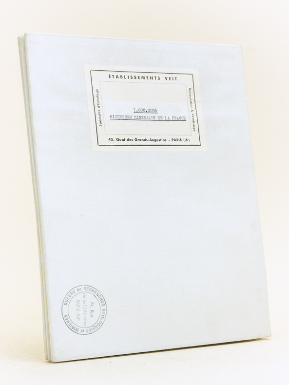
Ministère de l'Industrie
Carte des Richesses Minérales de la France établie par la Direction des Mines (Bureau de Documentation Minière) et le Bureau de Recherches Géologiques et Minières. Situation au 1er avril 1959
Carte entoilée au 1:1 000 000 dessinée sur le fond topographique de la carte de l'IGN, Ministère de l'Industrie, BRGM, Etablissements Veit, format 122 x 103 cm
Bookseller reference : 44984
|
|
|
Ministère de l'Industrie
Carte des Richesses Minérales de la France établie par la Direction des Mines (Bureau de Documentation Minière) et le Bureau de Recherches Géologiques et Minières. Situation au 1er avril 1959
Carte entoilée au 1:1 000 000 dessinée sur le fond topographique de la carte de l'IGN, Ministère de l'Industrie, BRGM, Etablissements Veit, format 122 x 103 cm Bel exemplaire en parfait état Français

|
|
|
Ministère de l'Intérieur
Carte a 1/100.000. feuille XV-34 TOULOUSE (Haute-Garonne)
Paris Librairie Hachette et Cie 1892 in 12 (16x10) 1 carte routière en couleurs, imprimée sur papier, de format : 45 x 57 cm, pliée sous chemise rigide de percaline rouge de l'éditeur, plat supérieur titré. Carte gravée originale avec représentation du relief, et le tracé des routes, chemins vicinaux, et autres. Carte de la France dressée par ordre du Ministre de l'Intérieur a 1/100.000e, feuille XV-34 TOULOUSE (Haute-Garonne). Bel exemplaire ( Photographies sur demande / We can send pictures of this print on simple request )
Bookseller reference : 48694
|
|
|
Ministère de l'Intérieur
Carte a 1/100.000. feuille XV-36 PAMIERS (Ariège)
Paris Librairie Hachette et Cie 1893 in 12 (16x10) 1 carte géographique en couleurs, imprimée sur papier, de format : 45 x 57 cm, pliée sous chemise rigide de percaline rouge de l'éditeur, plat supérieur titré. Carte gravée originale avec représentation du relief, et le tracé des routes, chemins vicinaux, et autres. Carte de la France dressée par ordre du Ministre de l'Intérieur a 1/100.000e, feuille XV-36 PAMIERS (Ariège). Bel exemplaire ( Photographies sur demande / We can send pictures of this print on simple request )
Bookseller reference : 48687
|
|
|
Ministère de l'Intérieur
Carte a 1/100.000. feuille XV-37 FOIX (Ariège)
Paris Librairie Hachette et Cie 1893 in 12 (16x10) 1 carte géographique en couleurs, imprimée sur papier, de format : 45 x 57 cm, pliée sous chemise rigide de percaline rouge de l'éditeur, plat supérieur titré. Carte gravée originale avec représentation du relief, et le tracé des routes, chemins vicinaux, et autres. Carte de la France dressée par ordre du Ministre de l'Intérieur a 1/100.000e, feuille XV-37 FOIX (Ariège). Bel exemplaire ( Photographies sur demande / We can send pictures of this print on simple request )
Bookseller reference : 48691
|
|
|
Ministère de l'Intérieur
Carte a 1/100.000. feuille XVI-34 CASTRES (Tarn
Paris Librairie Hachette et Cie 1893 in 12 (16x10) 1 carte routière en couleurs, imprimée sur papier, de format : 45 x 57 cm, pliée sous chemise rigide de percaline rouge de l'éditeur, plat supérieur titré. Carte gravée originale avec représentation du relief, et le tracé des routes, chemins vicinaux, et autres. Carte de la France dressée par ordre du Ministre de l'Intérieur a 1/100.000e, feuille XVI-34 CASTRES (Tarn). Bel exemplaire ( Photographies sur demande / We can send pictures of this print on simple request )
Bookseller reference : 48684
|
|
 Receive by email
 Download as PDF document
 RSS feed


