|
No Author
Map of Raymond, Alberta, West of Fourth Meridian, Scale 1:50,000
36" x 25.5". Indicates 25 foot contours, water bodies, roads, rail lines, structures, etc. Light wear. Unmarked. Book

|
|
|
No Author
Map of Township of Guelph, Ontario
25.5" x 16 3/8". Grey colouring. Includes owners' names for most acreages outside the city of Guelph. Map of Village of Hartfield (where Fergus Road meets Woolwich Road) in upper left corner, Date lightly handwritten in pencil (twice). 5" opening near left side of bottom edge is barely visible. A wonderful historical and genealogical reference ideally suited to framing and displaying in home or office. Please note that our photo shows only the left half of the map. Book

|
|
|
No Author
Map of Warner County, Alberta, West of Fourth Meridian, Scale 1:50,000
36" x 25.5". Indicates 25 foot contours, water bodies, roads, rail lines, structures, etc. Light wear. Unmarked. Book

|
|
|
No Author
Mapas Turisticos Provinciales - Islas Canarias: Aprobados Por El Consejo Superior Geographico
Text in Spanish. One-sided color map of the Islas Canarias. 69 x 45cm. Clean and unmarked with moderate wear. Includes tourist information. A quality vintage copy. Book

|
|
|
No author
Newnes Motorists Touring Maps and Gazetteer
15th edition 2nd impression. 4to, 64 pages, maps, maps on front and back endpapers. Poor condition hardback gilt writing on spine and front cover, hinge loose, some damage to bottom of spine some loss at head of spine. Edges of pages browning. 39096. eng
|
|
|
No Author
Picture Butte, Lethbridge County, Alberta, West of Fourth Meridian, Scale 1:50,000
36" x 25.5". Indicates 25 foot contours, water bodies, roads, rail lines, structures, etc. Light wear. Book

|
|
|
No Author
Road Map scale: 3 Miles to 1 inch for Motoring Cycling and Hiking: Section LL Exeter Torquay Plymouth Dartmoor Barnstaple Etc.
W. & A. K. Johnston Ltd 1949. code 12/49 presumed to be December 1949. Large colour printed map folding down into pictorial card covers printed in red and green. Covers very good with light wear only. Map clean and bright no annotations or inscriptions a single 1cm split at central folding otherwise very light wear. A very good copy. Paperback. Very Good. W. & A. K. Johnston Ltd Paperback
Ссылка продавца : 029337

|
|
|
No Author
Rochester Guidebook
Ex-library book with the usual stamps, stickers, etc. Binding is solid and text/interior is clean and free of marking of any kind. 128 pages in small format. Rochester, New York's first guide book, an alphabetical listing of sites, businesses, educational facilities, government, pastimes, clubs, philanthropies "and other interests." Fold-out city map at front with a few small tears at attachment points to book, b&w photos, a few ads at back. Binding is worn and appears to be the library's with paperback covers adhered to hardback boards.

|
|
|
No Author
Skiff, Alberta, West of Fourth Meridian, Scale 1:50,000
36" x 25.5". Indicates 25 foot contours, water bodies, roads, rail lines, structures, etc. Light wear. Book

|
|
|
No Author
SOUTH AMERICA From the Best Authorities Inc. Falkland Islands ORIGINAL ANTIQUE MAP
T. Tegg No date but circa 1840. An original copper engraved map entitled SOUTH AMERICA From the Best Authorities; the Falklands islands are also depicted. Plate measures 21.2 x 24.5cm. Originally from an atlas with a central fold. Very good condition with slight dust marking. Very Good. T. Tegg unknown
Ссылка продавца : 020932

|
|
|
No Author
THE ISLAND OF SUMATRA ORIGINAL COLOUR MAP
London: Edward Stanford No date but circa 1910. A fine coloured map of the island of Sumatra measuing 19. x 32.5cm. Originally from an atlas with 3 fold lines. Very good condition. Very Good. Edward Stanford unknown
Ссылка продавца : 020930

|
|
|
No Author
Travers, Alberta - West of Fourth Meridian, Scale 1:50,000
36" x 25.5". Indicates 25 foot contours, water bodies, roads, rail lines, structures, etc. Light wear. Book

|
|
|
No Author
WESTERN DIVISION OF THE UNITED STATES ORIGINAL ANTIQUE MAP
Unknown 1884. No date but circa 1884. An original colour map printed on thick paper. Plate measures 25.4 x 32.5cm. Originally from an atlas with a central fold. Very good condition. Am attractive genuine antique map. Very Good. Unknown unknown
Ссылка продавца : 020934

|
|
|
No author noted
Sinclair Map of Florida
<p>Rand McNally The map is not dated but Sinclair oil has not been around for awhile and there are no zip codes and no interstates. There are a couple of small faint stains and creases. There is a letter written in ink on the front of the map. In really nice condition for its' age. Edition Not Stated. Unbound. Good/No Jacket. 281/2"x 18' Unfolded.</p> Rand McNally paperback
Ссылка продавца : 447

|
|
|
Noble, Isabella; Noble, John; Quintero, Josephine; Sainsbury, Brendan
Andalucia : Lonely Planet Guide
Appears unused. No marks or inscriptions. No creasing to covers or to spine. A very clean very tight copy with bright unmarked boards and no bumping to corners. 391pp. Lonely Planet guide to the Andalucia region of Spain including Seville and Gibraltar.

|
|
|
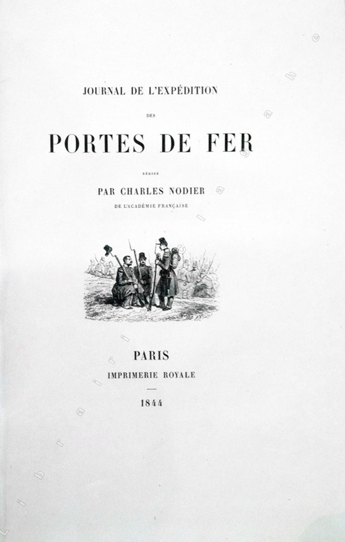
Nodier (Charles) :
Journal de l'Expédition des Portes de Fer.
Paris, Imprimerie Royale, 1844 ; grand in-8 ; cartonnage à la bradel de l'éditeur ; [4], XVI, 329 pp., [1] f. blanc, 40 planches hors-textes tirées sur chine contrecollées, protégées par des serpentes légendées et une carte dépliante en fin d'ouvrage et 200 vignettes gravées sur bois dans le texte.
Ссылка продавца : 13368
|
|
|
NOELLAT (Jean-Baptiste).
[RHÔNE] Nouvelle carte topographique et statistique du département du Rhône réduite d'après la grande carte de Cassini.
Lyon et Villefranche, 1827. 821 x 593 mm.
Ссылка продавца : LBW-5138

|
|
|
NOEL (Joseph).
Harper's ferry en 1865.
Paris, [circa 1860]. 129 x 166 mm.
Ссылка продавца : LBW-1254

|
|
|
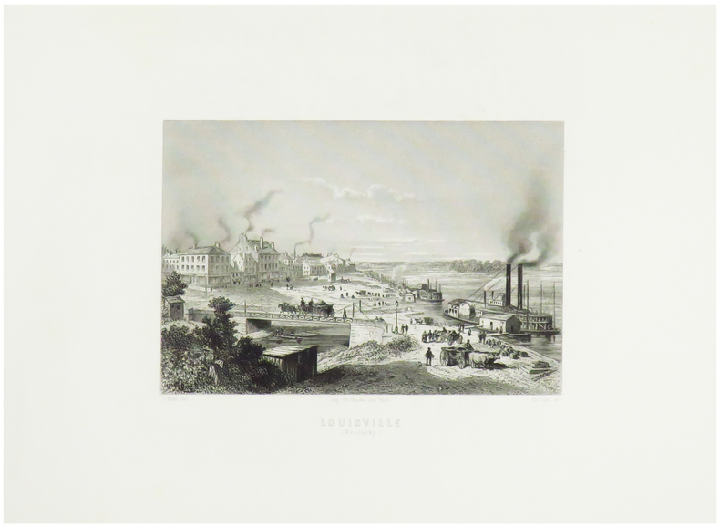
NOEL (Joseph).
Louisville (Kentucky).
Paris, [circa 1860]. 128 x 162 mm.
Ссылка продавца : LBW-1253
|
|
|
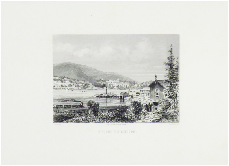
NOEL (Joseph).
Rivière du Hudson.
Paris, [circa 1860]. 124 x 159 mm.
Ссылка продавца : LBW-1251
|
|
|
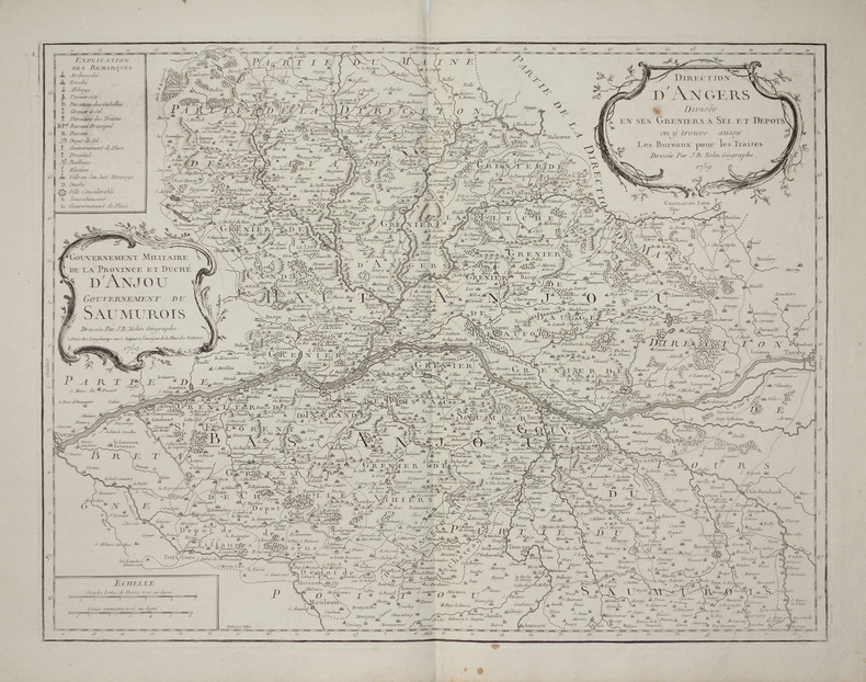
NOLIN (Jean-Baptiste).
[ANJOU/GRENIERS à SEL] Direction d'Angers divisée en ses greniers à sel et dépôts, on y trouve aussy les bureaux pour les traites - Gouvernement militaire de la province et duché d'Anjou, gouvernement du Saumurois.
Paris, Longchamps, 1759. 474 x 613 mm.
Ссылка продавца : LBW-2797
|
|
|
NOLIN (Jean-Baptiste).
[ANJOU/GRENIERS à SEL] Gouvernement militaire de la province et Duché d'Anjou. Gouvernement du Saumurois - Direction d'Angers divisée en ses greniers à sel et dépôts, on y trouve aussy les bureaux pour les traites.
Paris, Mondhare et Jean. 1787 472 x 614 mm ; repliée sous couverture cartonnée recouverte de papier bleu de l'époque (200 x 127mm) ; étiquette sur le premier plat portant le titre manuscrit à l'encre.
Ссылка продавца : LBW-8429

|
|
|
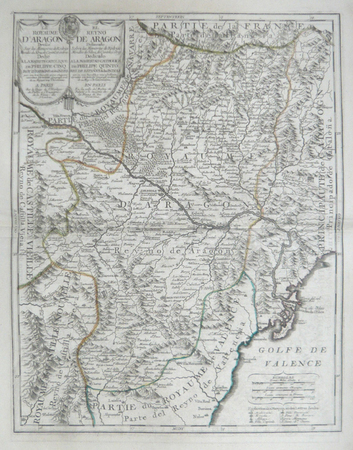
NOLIN (Jean-Baptiste);
[ARAGON] Le royaume d'Aragon dressé sur les mémoires de Rodrigo Mandes de Silva, de Cantel, et autres.
Paris J.B. Nolin circa 1705 550 x 430 mm.
Ссылка продавца : LBW06191
|
|
|
NOLIN (Jean-Baptiste);
[GALICE/ASTURIES] Le royaume de Galice divisé en plusieurs territoires, et les Asturies divisées en Asturie d'Oviedo et de Santillana. Dressez sur les mémoires de Rodrigo Mendez Silva.
Paris J.B. Nolin 1704 En deux feuilles jointes 447 x 731 mm.
Ссылка продавца : LBW06193

|
|
|
NOLIN (Jean-Baptiste).
[GUYENNE & GASCOGNE] Le gouvernement général de Guienne et Gascogne dédié à Sa Majesté, divisé en deux lieutenances générales de Haute et Basse Guienne et en une lieutenance de roy particulier.
Paris, Mondhare et Jean, 1787. 462 x 618 mm ; repliée sous couverture cartonnée recouverte de papier bleu de l'époque (200 x 128mm) ; étiquette sur le premier plat portant le titre manuscrit à l'encre.
Ссылка продавца : LBW-8443

|
|
|
NOLIN (Jean-Baptiste).
[GUYENNE] Carte de la Guyenne, du Bourdelois, partie du Périgord et pays voisins.
À Bourdeaux, à la Bourse et au grand Bureau, 1776. 522 x 680 mm ; repliée sous couverture cartonnée recouverte de papier bleu de l'époque (200 x 128mm) ; étiquette sur le premier plat portant le titre manuscrit à l'encre.
Ссылка продавца : LBW-8458

|
|
|
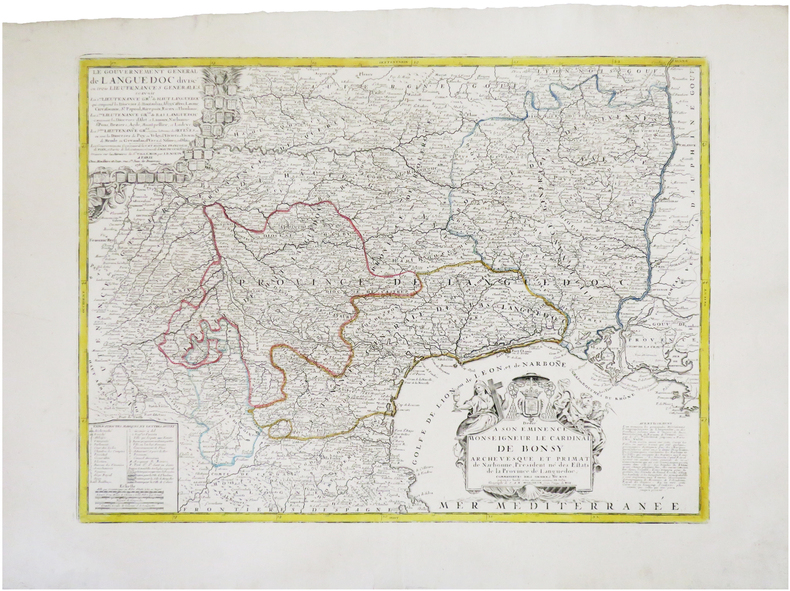
NOLIN (Jean-Baptiste).
[LANGUEDOC] Le gouvernement général de Languedoc divisé en trois lieutenances générales.
Paris, Mondhare et Jean, 1787. 450 x 610 mm.
Ссылка продавца : LBW-7845
|
|
|
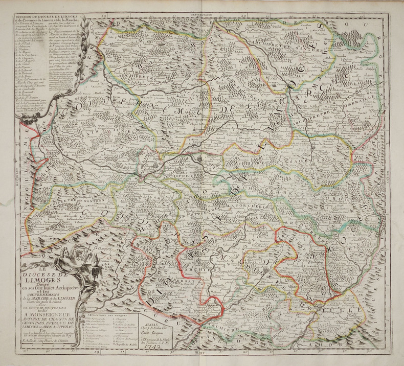
NOLIN (Jean-Baptiste).
[LIMOUSIN] Le Diocèse de Limoges divisé en ses dix huict archipretré et les gouvernemens de la Marche et du Limosin dans les quels il s'étend avec le diocèse de Tulles.
Paris, J.B. Nolin, 1742. 500 x 544 mm.
Ссылка продавца : LBW-2713
|
|
|
NOLIN (Jean-Baptiste).
[LYONNAIS] Le gouvernement général et militaire du Lyonnois comprenant les provinces du Lyonnois, du Forez, et du Beaujolois.
Paris, Mondhare et Jean, [circa 1780]. En deux feuilles pouvant être jointes pour former une carte de 779 x 616 mm ; repliée sous couverture cartonnée recouverte de papier bleu de l'époque (199 x 128mm) ; étiquette sur le premier plat portant le titre manuscrit à l'encre.
Ссылка продавца : LBW-8422

|
|
|
NOLIN (Jean-Baptiste);
[PAYS BASQUE ESPAGNOL] La Biscaye divisée en ses quatre parties principales et le royaume de Navarre divisé en ses merindades.
Paris J.B. Nolin circa 1705 450 x 577 mm.
Ссылка продавца : LBW06192

|
|
|
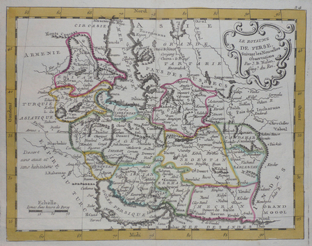
NOLIN (Jean-Baptiste);
[PERSE] Le royaume de Perse.
circa 1780 202 x 261 mm.
Ссылка продавца : LBW0251a
|
|
|
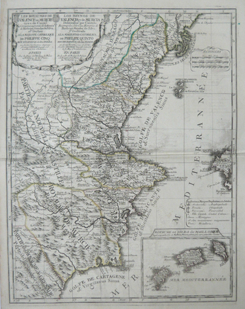
NOLIN (Jean-Baptiste);
[VALENCE/MURCIE] Les royaumes de Valence et Murcie tirez de Cantel. Corrigés et augmentés sur les mémoires de Rodrigo Mendes de Silva.
Paris J.B. Nolin circa 1705 560 x 434 mm.
Ссылка продавца : LBW06190
|
|
|
NOLIN (Jean-Baptiste).
Amérique septentrionale avec les nouvelles découvertes fait au nord, par les Russes et les Anglois.
[Paris, Mondhare, 1791]. 206 x 229 mm.
Ссылка продавца : LBW-4850

|
|
|
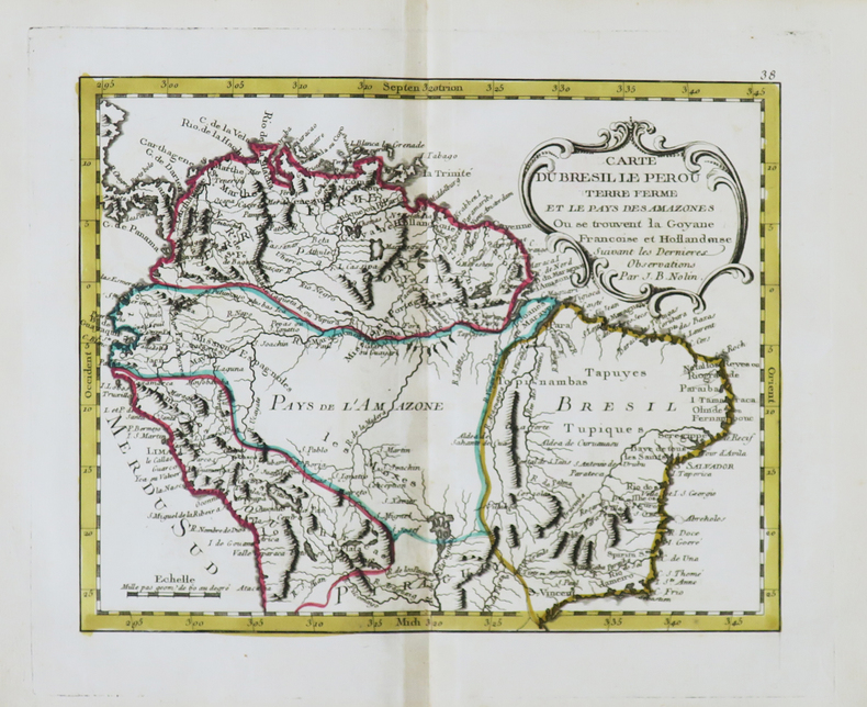
NOLIN (Jean-Baptiste).
Carte du Brésil le Pérou Terre Ferme et le Pays des Amazones où se trouvent la Goyane françoise et hollandoise.
[Paris, Mondhare, 1791]. 205 x 257 mm.
Ссылка продавца : LBW-4854
|
|
|
NOLIN (Jean-Baptiste).
Carte de l'étendüe de la jurisdiction de la Cour des Aydes composée sur les mémoires de ladite compagnie.
Paris, chez l'auteur, 1709. 412 x 524 mm.
Ссылка продавца : LBW-6955

|
|
|
NOLIN (Jean-Baptiste).
Golfe du Mexique.
[Paris, Mondhare, 1791]. 203 x 262 mm.
Ссылка продавца : LBW-4853

|
|
|
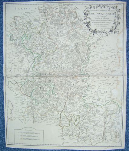
NOLIN, Jean Baptiste
Gouvernement Général Militaire de Bourgogne qui comprend le Duché de Bourgogne, divisé en tous ses Présidiaux et Bailliages et les Provinces de Bresse et de Bugei. [ Carte ]
Dressé sur les dernières Observations par J. B. Nolin Géographe, gravée par Vallet, carte au format 535 x 650 mm, limites des présidiaux et bailliages rehaussées en couleurs, Chez Longchamps, Paris, 1758
Ссылка продавца : 26476
|
|
|
NOLIN (Jean-Baptiste).
Hémisphère occidental ou Nouveau Monde.
[Paris, Mondhare, 1791]. 224 x 185 mm.
Ссылка продавца : LBW-4839

|
|
|
NOLIN (Jean-Baptiste).
L'Empire de la Chine avec les isles du Japon et la Corée.
[Paris, Mondhare, 1791]. 204 x 261 mm.
Ссылка продавца : LBW-4845

|
|
|
NOLIN (Jean-Baptiste).
L'Europe divisée en touttes ses régions et grands estats.
Paris, Basset, 1817. 477 x 654 mm.
Ссылка продавца : LBW-4992

|
|
|
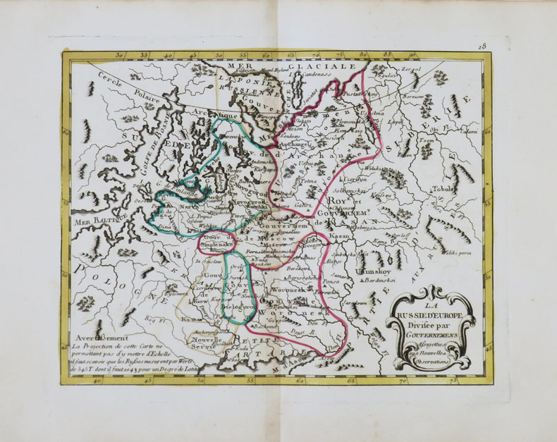
NOLIN (Jean-Baptiste).
La Russie d'Europe divisée par gouvernemens.
[Paris, Mondhare, 1791]. 202 x 261 mm.
Ссылка продавца : LBW-4844
|
|
|
NOLIN (Jean-Baptiste);
Le royaume de France avec ses acquisitions divisé en gouvernemens de provinces.
Paris chés l'auteur 1747 497 x 606 mm.
Ссылка продавца : LBW-381
|
|
|
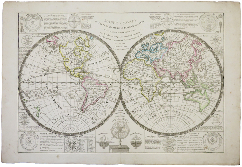
NOLIN (Jean-Baptiste).
Mappe-monde ou carte générale de la terre et des mers.
Paris, Jean, [circa 1800]. 513 x 754 mm.
Ссылка продавца : LBW-744
|
|
|
NOLIN (Jean-Baptiste).
Partie septentrional des possessions angloise en Amérique où se trouvent l'isle de Terre Neuve le Canada et la Nouvelle Écosse.
[Paris, Mondhare, 1791]. 200 x 258 mm.
Ссылка продавца : LBW-4851

|
|
|
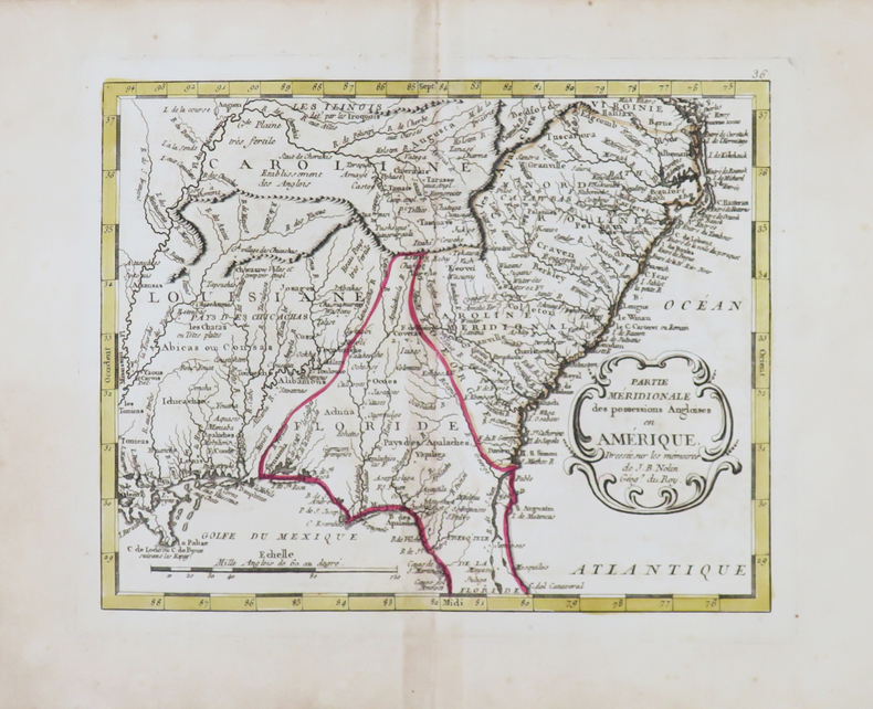
NOLIN (Jean-Baptiste).
Partie méridionale des possessions angloises en Amérique.
[Paris, Mondhare, 1791]. 203 x 260 mm.
Ссылка продавца : LBW-4852
|
|
|
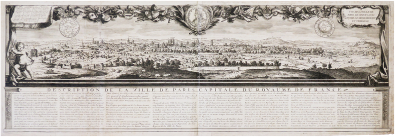
NOLIN (Jean-Baptiste).
Vue de la ville de Paris de Mont Louis entre le Ménil Montant et Charonne.
[Paris], J.B. Nolin, [circa 1690]. 255 x 775 mm.
Ссылка продавца : LBW-7907
|
|
|
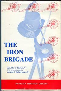
Nolan Alan T./Hoyt III Wilson K. maps/Robertson Jr. James I. intro
The Iron Brigade: A Military History Michigan Heritage Library Series
Ann Arbor/Barrien Springs: Historical Society of Michigan/Hardscrabble Books 1983. 3rd edition. VG/Good dust jacket tape reinforcement to edges of dust jacket. xx 412 p. photos maps map on endpapers appendices notes biblio index 8vo; Historical Society of Michigan/Hardscrabble Books hardcover
Ссылка продавца : 66647 ISBN : 091505616X 9780915056163
|
|
|
Nolan Alan T. AUTOGRAPHED/Hoyt III Wilson K. maps/Robertson Jr. James I. intro
The Iron Brigade: A Military History Michigan Heritage Library Series
Ann Arbor/Barrien Springs: Historical Society of Michigan/Hardscrabble Books 1983. 3rd edition. Near Fine/Near Fine dust jacket. SIGNED BY AUTHOR xx 412 p. photos maps map on endpapers appendices notes biblio index 8vo; Historical Society of Michigan/Hardscrabble Books hardcover
Ссылка продавца : 64331 ISBN : 0870201573 9780870201578

|
|
|
Nolan Alan T./Hoyt III Wilson K. maps
The Iron Brigade: A Military History
Bloomington: Indiana University Press 1995. 3rd paperback printing. VG. xiv 417 p. photos maps appendices notes biblio index 8vo pictorial paperback; Indiana University Press paperback
Ссылка продавца : 51921 ISBN : 0253208637 9780253208637

|
|
|
NOLIN, Jean Baptiste
Gouvernement Général Militaire de Bourgogne qui comprend le Duché de Bourgogne, divisé en tous ses Présidiaux et Bailliages et les Provinces de Bresse et de Bugei. [ Carte ]
Dressé sur les dernières Observations par J. B. Nolin Géographe, gravée par Vallet, carte au format 535 x 650 mm, limites des présidiaux et bailliages rehaussées en couleurs, Chez Longchamps, Paris, 1758 Mouill. et frott. en marge droite. Prix en l'état. Français

|
|
 Получить результаты поиска по электронной почте
 Загрузить результаты в формате PDF
  RSS-канал


