|
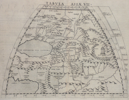
PTOLEMEE Claude & RUSCELLI (Girolamo).
[PERSE] Tabula Asiae VII.
[Venise, 1561]. 185 x 247 mm.
Riferimento per il libraio : LBW02516
|
|
|
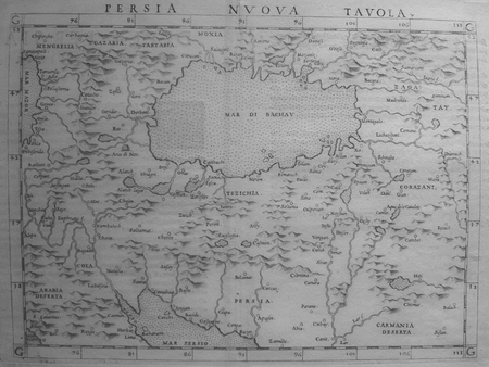
PTOLEMEE (Claude) & RUSCELLI (Girolamo).
[PERSE] Persia nuova tavola.
[Venise, 1561]. 183 x 246 mm.
Riferimento per il libraio : LBW0251d
|
|
|
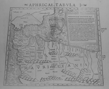
PTOLEMEE Claude & MUNSTER (Sebastian).
Aphricae tabula I.
[Bâle, 1552]. 268 x 333 mm.
Riferimento per il libraio : LBW01b4b
|
|
|
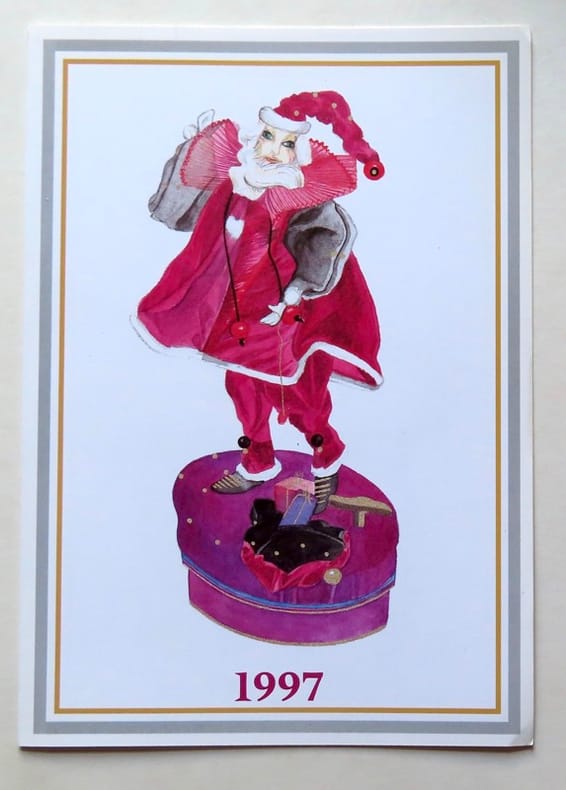
PTT - Poste suisse:
4 timbres-postes - Boîtes à musique et automates.
Berne, PTT, 1997. Carte de voeux de la Poste suisse, comprenant 4 timbres-poste (valeur 70 + 90 centimes suisses + 1,10 + 1,80 francs suisses). Oblitération du jour d'émission (10.09.1996).
Riferimento per il libraio : 18504
|
|
|
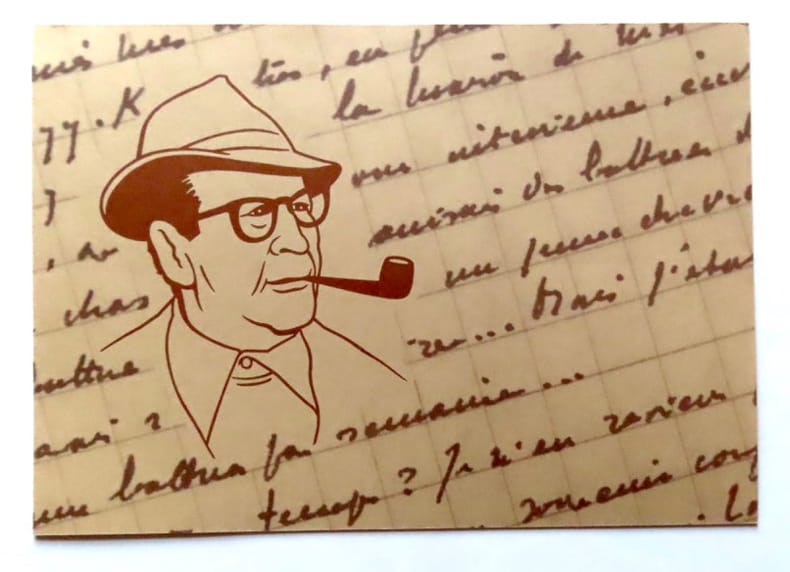
PTT - Poste suisse:
Emission commune Suisse / Belgique / France - Georges Simenon.
Berne, PTT, 1994. Carte de voeux de la Poste suisse, comprenant un timbre-poste (valeur 1 franc suisse) au portrait de Simenon. Oblitération du jour d'émission (15.10.1994).
Riferimento per il libraio : 18502
|
|
|
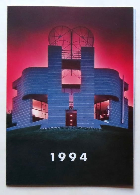
PTT - Poste suisse:
Europa 1993. Timbres-poste spéciaux Art contemporain: Architecture.
Berne, PTT, 1994. Carte de voeux de la Poste suisse, comprenant 2 timbres-poste (valeur 60 + 80 centimes suisses). Oblitération du jour d'émission (23.11.1993).
Riferimento per il libraio : 18503
|
|
|
Published by IMP. HAIRIE et CIE.
[OTTOMAN MAP] [Port of Aden].
Very Good Turkish, Ottoman (1500-1928) Original color map. 21x19,5 cm. In Ottoman script. No scale, no mapmaker info. Slightly dumped on right margin. Little wear on peninsula view. Otherwise a good copy. Folded. [Ottoman map of Aden Bay and Port].
|
|
|
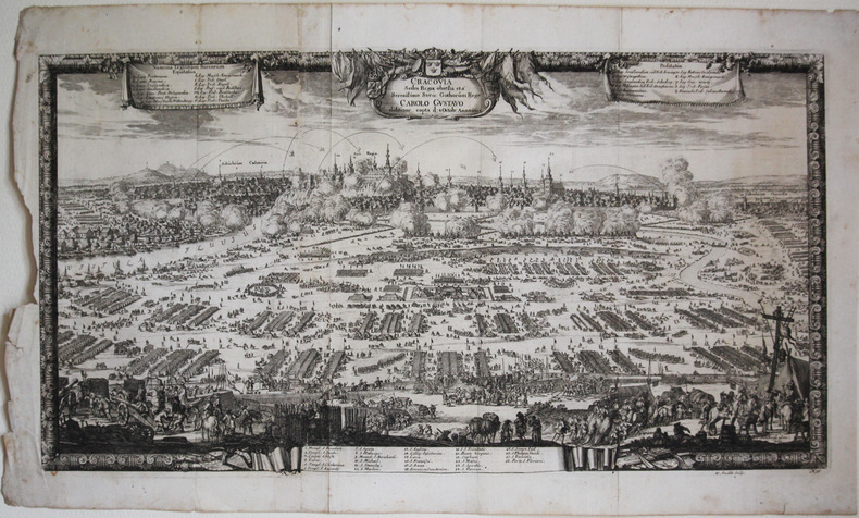
PUFENDORF (Samuel).
[CRACOVIE] Cracovia sedes regia obsessa et a serenissimo Sveo. Gothorum rege Carolo Gustavo ... 1655.
[1696]. 300 x 555 mm.
Riferimento per il libraio : LBW-2631
|
|
|
PURDY, JOHN.
The New Sailing Directory for the Coasts of Spain and Portugal, from Cape Finisterre to Cadiz, and Thence to the Eastward of Malaga: Composed to Accompany the Chart.
London, Laurie, 1839. 8vo. In contemporary blank wrappers with part of original printed wrapper pasted on. Stamp to front wrapper and title-page. Internally fine and clean. iv, 38 pp.
Riferimento per il libraio : 57123
|
|
|
PURDY, JOHN.
The New Sailing Directory for the Coasts of Spain and Portugal, from Cape Finisterre to Cadiz, and Thence to the Eastward of Malaga: Composed to Accompany the Chart.
London, Laurie, 1839. 8vo. In contemporary blank wrappers with part of original printed wrapper pasted on. Stamp to front wrapper and title-page. Internally fine and clean. iv, 38 pp.
|
|
|
Putnam, William C.
Map Interpretation with Military Applications
37 pages including index, selected references and black and white illustrations. Average wear. Binding sound. Former U.S. military copy with usual internal markings. No external markings. Solid working copy in maroon cloth-covered boards Book
|
|
|
PUY DE DOME
Carte d?partementale couleurs au 1/200 000e. D?but XXe.
Une feuille 55 x 72 cm repli?e.
|
|
|
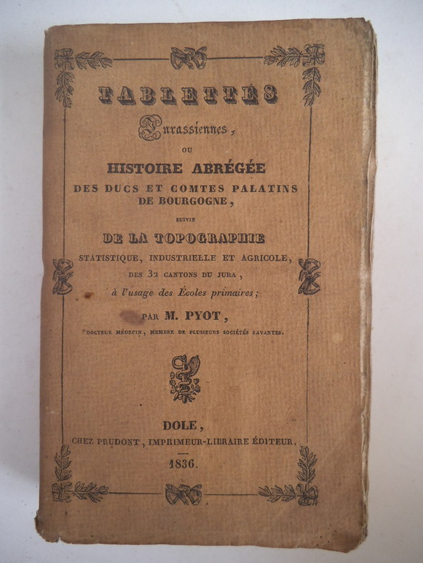
PYOT M.
Tablettes Jurassiennes
ou histoire abrégée des Duc et Comtes Palatins de bourgogne suivie de la topographie statistique , industrielle et agricole des 32 cantons du Jura ; A l’usage des écoles primaires. In 12 broché couverture imprimée faux-titre,carte du département du jura divisé en 32 cantons au verso,titre, (signature de l’auteur)248 pages,catalogue,Dijon 1836 (très pâle mouillure en pied au milieu du volume sans gravité) sinon bon exemplaire
Riferimento per il libraio : 2493
|
|
|
PYRENEES
Carte guide campbell. N?13 : Pyr?n?es (Bayonne). Echelle 1/320 000?me. Sans date.
Une feuille. 86x68 cm.
|
|
|
PYRENEES ORIENTALES
Carte couleurs d?partementale au 1/200 000?me. Sans date.
Une feuille. 56x76 cm.
|
|
|
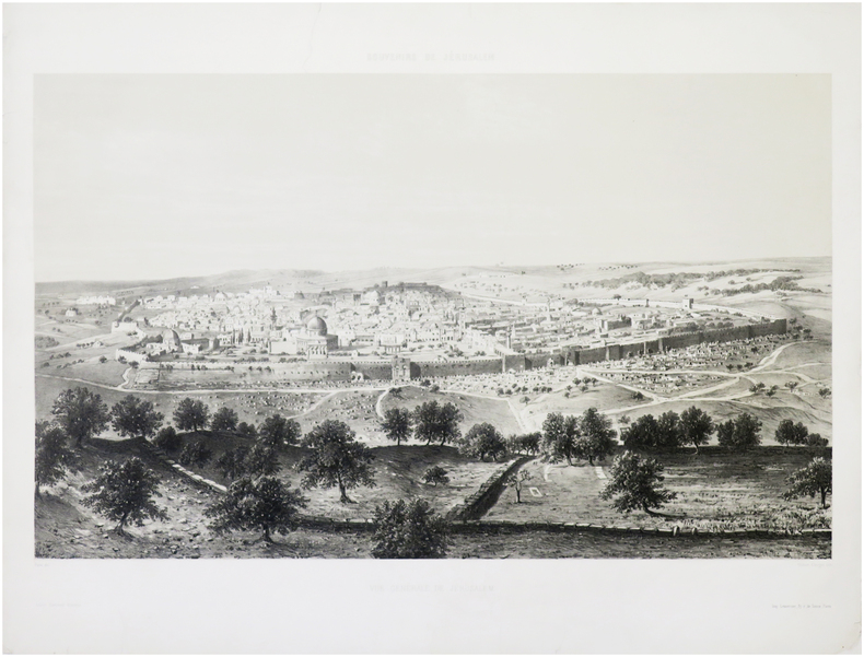
PÂRIS (François-Edmond).
[JÉRUSALEM] Souvenirs de Jérusalem. Vue générale de Jérusalem.
Paris, Arthus Bertrand, [1862]. 410 x 590 mm.
Riferimento per il libraio : LBW-7682
|
|
|
PÈRE CHRYSOLOGUE (Chrysologue de Gy, dit le) & BOUASSE-LEBEL.
[PLANISPHÈRE CÉLESTE BORÉAL] Planisphère céleste boréal projeté sur le plan de l'équateur.
Paris, Maison Bouasse-Lebel et ancienne Maison Basset réunies, [1862]. 730 x 670 mm.
Riferimento per il libraio : LBW-8444

|
|
|
Père Gibrat, père de la doctrine chrétienne
Traité de la géographie moderne à l'usage des collégiens et des pensions, enrichies de dix-huit cartes géographiques, d'une carte planisphère du globe terrestre, d'une sphère de Gnomonique, et d'un détail des Etats, et Provinces qui ont changé de Souverain ou devenus indépendants, à Toulouse, chez Joseph Dalles, imprimeur-libraire, rue des Changes, 1785.
in-12 (9,8 cm X 17,3 cm), XXIV + 540 pp, reliure plein veau, dos à 5 nerfs, pièce de titre, caisson orné de feuillages dorés, 3 tranches marbrées. Signet
Riferimento per il libraio : E0236

|
|
|
PÉRIGOT, Ch.
Carte de l'AMÉRIQUE SEPTENTRIONALE (extraite de l'Atlas général, par Levasseur E., publiée par la Librairie de Charles Delagrave, pl. 90, éditée vers 1870
Paris Librairie de Charles Delagrave et Cie, Editeurs 1870 1 carte géographique gravée ancienne de l'AMÉRIQUE SEPTENTRIONALE, imprimée sur papier fort et coloriée à l'époque, de format : 32,5 x 47 cm, trace de pliure centrale. Carte originale gravée sur acier, figurant la géographie de l'Amérique septentrionale. Les fonds de chacune des contrées de l'AMÉRIQUE SEPTENTRIONALE sont aquarellés chacun d'une couleur différente (original hand coloring). Carte dressée par Ch. Périgot. Bel exemplaire ( Photographies sur demande / We can send pictures of this print on simple request ) Envoi dans un emballage de protection (tube carton)
Riferimento per il libraio : 28556
|
|
|
PÉRIGOT, Ch.
Carte physique et politique des ÉTATS-UNIS (extraite de l'Atlas général, par Levasseur E., publiée par la Librairie de Charles Delagrave, pl. 91bis, éditée vers 1870
Paris Librairie de Charles Delagrave et Cie, Editeurs 1870 1 carte géographique gravée ancienne: Carte physique et politique des ÉTATS-UNIS, imprimée sur papier fort et coloriée à l'époque, de format : 32,5 x 47 cm, trace de pliure centrale. Carte originale gravée sur acier, figurant la géographie de l'Amérique septentrionale. Les fonds de chacune des contrées de la carte physique et politique des ÉTATS-UNIS sont aquarellés chacun d'une couleur différente (original hand coloring). Carte dressée par Ch. Périgot. Bel exemplaire ( Photographies sur demande / We can send pictures of this print on simple request ) Envoi dans un emballage de protection (tube carton)
Riferimento per il libraio : 28557
|
|
|
PÉRIGOT, Ch.
Carte de l'OCÉANIE CENTRALE, Australie et Nouvelle-Zélande (extraite de l'Atlas général, par Levasseur E., publiée par la Librairie de Charles Delagrave, pl. 95, éditée vers 1870
Paris Librairie de Charles Delagrave et Cie, Editeurs 1870 1 carte géographique gravée ancienne de l'OCÉANIE CENTRALE, Australie et Nouvelle-Zélande, imprimée sur papier fort et coloriée à l'époque, de format : 32,5 x 47 cm, trace de pliure centrale. Carte originale gravée sur acier, figurant la géographie de l'OCÉANIE CENTRALE, Australie et Nouvelle-Zélande, les fonds de chacune des contrées sont aquarellés chacun d'une couleur différente (original hand coloring). Carte dressée par Ch. Périgot. Bel exemplaire ( Photographies sur demande / We can send pictures of this print on simple request ) Envoi dans un emballage de protection (tube carton)
Riferimento per il libraio : 28558
|
|
|
PÉRIGOT, Ch.
Carte de l'AMÉRIQUE MÉRIDIONALE (extraite de l'Atlas général, par Levasseur E., publiée par la Librairie de Charles Delagrave, pl. 94, éditée vers 1870
Paris Librairie de Charles Delagrave et Cie, Editeurs 1870 1 carte géographique gravée ancienne de l'AMÉRIQUE MÉRIDIONALE, imprimée sur papier fort et coloriée à l'époque, de format : 47 x 32,5 cm, trace de pliure centrale. Carte originale gravée sur acier, figurant la géographie de l'Amérique méridionale. Les fonds de chacune des contrées de l'AMÉRIQUE MÉRIDIONALE sont aquarellés chacun d'une couleur différente (original hand coloring). Carte dressée par Ch. Périgot. Bel exemplaire ( Photographies sur demande / We can send pictures of this print on simple request ) Envoi dans un emballage de protection (tube carton)
Riferimento per il libraio : 28559
|
|
|
PÉRIGOT, Ch.
Carte de l'AFRIQUE (extraite de l'Atlas général, par Levasseur E., publiée par la Librairie de Charles Delagrave, pl. 86, éditée vers 1870
Paris Librairie de Charles Delagrave et Cie, Editeurs 1870 1 carte géographique gravée ancienne de l'AFRIQUE, imprimée sur papier fort et coloriée à l'époque, de format : 32,5 x 47 cm, trace de pliure centrale. Carte originale gravée sur acier, figurant la géographie de l'Afrique. Les fonds de chacune des contrées de l'AFRIQUE sont aquarellés chacun d'une couleur différente (original hand coloring). Carte dressée par Ch. Périgot. Bel exemplaire ( Photographies sur demande / We can send pictures of this print on simple request ) Envoi dans un emballage de protection (tube carton)
Riferimento per il libraio : 28560
|
|
|
PÉRIGOT, Ch.
Carte de l'ASIE et OCÉANIE CENTRALE, ou Malaisie (extraite de l'Atlas général, par Levasseur E., publiée par la Librairie de Charles Delagrave, pl. 82, éditée vers 1870
Paris Librairie de Charles Delagrave et Cie, Editeurs 1870 1 carte géographique gravée ancienne de l'OCÉANIE CENTRALE, ou Malaisie, imprimée sur papier fort et coloriée à l'époque, de format : 32,5 x 47 cm, trace de pliure centrale, trois petites tâches claires d'encre noire sur le tiers inférieur droit de la carte. Carte originale gravée sur acier, figurant la géographie de l'ASIE et OCÉANIE CENTRALE, ou Malaisie, les fonds de chacune des contrées sont aquarellés chacun d'une couleur différente (original hand coloring). Carte dressée par Ch. Périgot. Bel exemplaire ( Photographies sur demande / We can send pictures of this print on simple request ) Envoi dans un emballage de protection (tube carton)
Riferimento per il libraio : 28561
|
|
|
PÉRIGOT, Ch.
Carte de la: MAPPEMONDE, physique et commerciale (extraite de l'Atlas général, par Levasseur E., publiée par la Librairie de Charles Delagrave, pl. 5, éditée vers 1870
Paris Librairie de Charles Delagrave et Cie, Editeurs 1870 1 carte géographique gravée ancienne: MAPPEMONDE, physique et commerciale, imprimée sur papier fort et coloriée à l'époque, de format : 32,5 x 47 cm, trace de pliure centrale. Carte originale gravée sur acier, figurant la géographie de l'Afrique. Les fonds de chacune des contrées de la: MAPPEMONDE, physique et commerciale sont aquarellés chacun d'une couleur différente (original hand coloring). Carte dressée par Ch. Périgot. Bel exemplaire ( Photographies sur demande / We can send pictures of this print on simple request ) Envoi dans un emballage de protection (tube carton)
Riferimento per il libraio : 28562
|
|
|
PÉRIGOT, Ch.
Carte de la: GÉOGRAPHIE MATHÉMATIQUE OU COSMOGRAPHIQUE (extraite de l'Atlas général, par Levasseur E., publiée par la Librairie de Charles Delagrave, pl. 1bis, éditée vers 1870
Paris Librairie de Charles Delagrave et Cie, Editeurs 1870 1 carte géographique gravée ancienne de la: GÉOGRAPHIE MATHÉMATIQUE OU COSMOGRAPHIQUE, imprimée sur papier fort et coloriée à l'époque, de format : 32,5 x 47 cm, trace de pliure centrale. Carte originale gravée sur acier, figurant la géographie de la: GÉOGRAPHIE MATHÉMATIQUE OU COSMOGRAPHIQUE. Carte dressée par Ch. Périgot. Bel exemplaire ( Photographies sur demande / We can send pictures of this print on simple request ) Envoi dans un emballage de protection (tube carton)
Riferimento per il libraio : 28563
|
|
|
PÉRIGOT, Ch.
Carte Physique et Politique de l'ALLEMAGNE, ou ROYAUME DE PRUSSE, et de l'EMPIRE D'AUTRICHE (extraite de l'Atlas général, par Levasseur E., publiée par la Librairie de Charles Delagrave, pl. 65bis, éditée vers 1870
Paris Librairie de Charles Delagrave et Cie, Editeurs 1870 1 carte géographique gravée ancienne de l'ALLEMAGNE, ou ROYAUME DE PRUSSE, et de l'EMPIRE D'AUTRICHE, imprimée sur papier fort et coloriée à l'époque, de format : 32,5 x 47 cm, trace de pliure centrale, trois petites tâches claires d'encre noire. Carte originale gravée sur acier, figurant la géographie de l'ALLEMAGNE, ou ROYAUME DE PRUSSE, et de l'EMPIRE D'AUTRICHE, les fonds de chacune des contrées sont aquarellés chacun d'une couleur différente (original hand coloring). Carte dressée par Ch. Périgot. Bel exemplaire ( Photographies sur demande / We can send pictures of this print on simple request ) Envoi dans un emballage de protection (tube carton)
Riferimento per il libraio : 28564
|
|
|
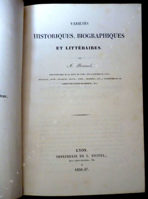
Pérricaud A.
Variétés Historiques Biographiques et Littéraires.
Lyon, Imprimerie Boitel, 1836-37 - In Octavo, reliure de travail demi basane , tranche sobrement titée au petit fer, 168 pages, parfaite pagination, légers frottement aux plats, belle tranche.
Riferimento per il libraio : 14017
|
|
|
QUATREFAGES Armand de:
Histoire générale des races humaines. Introduction à l'étude des races humaines.
Paris, A. Hennuyer, 1889. Petit in-4 de XXXIII-[1]-618 pages, demi-chagrin rouge, dos à nerfs, tête dorée.
Riferimento per il libraio : 20817
|
|
|
QUAMMEN DAVID with maps by ELLINGSEN KRIS
THE SONG OF THE DODO - ISLAND BIOGEOGRAPHY IN AN AGE OF EXTINCTIONS
Hutchinson London 1996. 702 pp including index maps fine hard backcopy in like illustratedd/j. Hutchinson, London, 1996 hardcover
Riferimento per il libraio : 228746
|
|
|
QUERRET (Jean)
Carte du Comté de Bourgogne dédiée à Monseigneur de Machault,…, levée par ordre de la Cour par le sieur Jean Querret ingénieur des Ponts et Chaussées, vue et vérifiée par Mrs Cassini et Maraldi de l'Académie Royale des Sciences.
1748 entoilée. Carte en 4 feuilles assemblées, 113 x 179 cm, limites aquarellées, P. Jean Lattre 1748
Riferimento per il libraio : 14527
|
|
|
Quennell, Peter & Hodge, Alan (editors)
History Today : April 1974
No marks or inscriptions. No creasing to covers. A very clean very tight copy with bright unmarked boards, very slightly dusty rear and no bumping to corners. 75pp. Periodical magazine with feature articles on Roman Portrait Busts, Rodin's Monument to Balzac, Coal, Art and the Beaumonts - Midland Collieries, Thomas Aquinas 1274, Marshal Vauban - Writer and Critic, Richard Cocks - English Merchant in Japan 1613, a Monastic Hegira - Trappists from Normandy and the Golden Age of the County Map - 16th Century plus book reviews and letters.

|
|
|
QUINTAC A de (baron)
Pour gagner au bridge-plafond.
Paris, Garnier Fères, 1932. 12 x 18, 130 pp., nombreuses figures, broché, bon état.
Riferimento per il libraio : 20433
|
|
|
QUINTE-CURCE:
Q. Curtii Rufi Alexander Magnus et in illum commentarius Samuelis Pitisci quo antiquitates persarum, macedonum, phoenicum, carthaginensium, romanorum babbyloniorum, indorum, atheniensium ex auctoribus idoneis fere septingentis graecis et latinis, veteribus & recentioribus perpetuo tenore explicantur.
Hagae Comitum [La Haye], Apud Petrum van Thol, 1708. 2 volumes in-8 de [68]-103-[5]-378; [2]-379 à 855-[167] pages, plein maroquin citron, dos lisse orné de filets et roulette dorée, pièces de titre, de tomaison (et de cote au premier volume) bordeaux, double filets dorés sur les plats, simple sur les coupes, tranches dorées, roulette int. Tampon avec un L couronné répété au début du texte de chaque volume. Coiffes supérieures frottées.
Riferimento per il libraio : 13757
|
|
|
Quintero Cartes Juan Bautista
Historia de la Diputación Provincial de Huelva
2016. Paperback. Very Good-New. Rare book paperback
Riferimento per il libraio : 573782 ISBN : 8481635480 9788481635485
|
|
|
Quixley R. C. E.
ANTIQUE MAPS OF CORNWALL AND THE ISLES OF SCILLY
Quixley 1966. pp. 60; reproductions of b/w maps throughout with accompanying "bibliography". Dust jacket somewhat browned and marked a few nicks to edges now protected in a clear removable archival sleeve. Hardback binding with several very small puncture marks to rear board and inside front board. Contents clean and tight title page and front end paper lightly marked. A good to very good copy. 1st. Very Good/Very Good. 4to Landscape. Quixley hardcover
Riferimento per il libraio : 029651

|
|
|
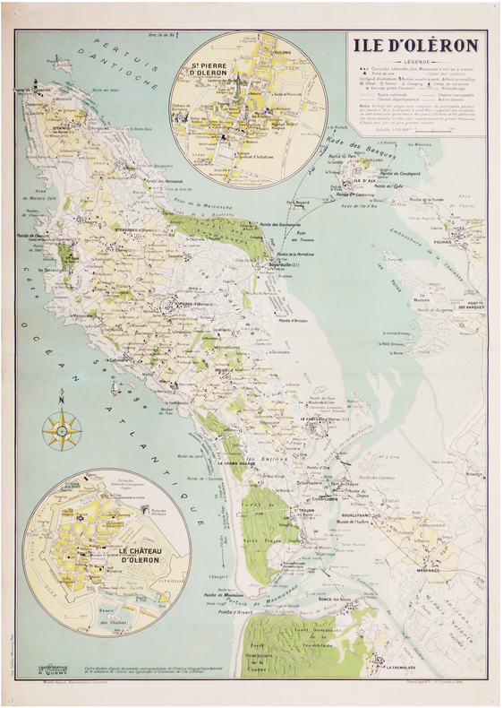
QUÉMY (Robert).
[ÎLE d'OLÉRON] Île d'Oléron.
Paris, R. Quémy, 1956. 725 x 530 mm.
Riferimento per il libraio : LBW-7198
|
|
|
R. WAGNER
Belagerung von Strasburg. Kartem
Ottmann.Strassburg..XIXème.13 cartes entoilées en couleurs.Rempliées.TBE.Cartes dans un étui en forme de livre de format in-4,en demi-chagrin;caractères dorés.
Riferimento per il libraio : 47471
|
|
|
R. Van Passen
Kontich in oude prentkaarten
Zaltbommel, Europese Bibliotheek - Biblioth que Europ enne, 1972 Geillustreerde kartonomslag,76 pagina's, 15 x 20 cm.
Riferimento per il libraio : 64832
|
|
|
R. Harris
Weald & Downland Open Air Museum
No marks or inscriptions. No creasing to covers or to spine. A very clean very tight copy with bright unmarked boards, minor traces of storage and no bumping to corners. 56pp. Features on old and traditional buildings within the site explaining their constructional methods and history. Well illustrated. Tucked in are five colour postcards from the Museum.

|
|
|
RA. T. Marston And G. Painter. Skelton Other. Maps R. A.
Vinland Map and the Tartar Relation
Yale University Press 1966. Hardcover. Very Good. Disclaimer:A copy that has been read but remains in excellent condition. Pages are intact and are not marred by notes or highlighting but may contain a neat previous owner name. The spine remains undamaged. At ThriftBooks our motto is: Read More Spend Less.Dust jacket in good condition. Third printing. Minor shelf and handling wear overall a clean solid copy with minimal signs of use. Not price clipped. Square binding with straight points. Small clean tear at lower foot of front hinge of board and spine. All interior and text portions are very clean and free from additional markings of any kind. Shelved and shipped in new laminate wrapper after photography. Secure packaging for safe delivery.Dust jacket quality is not guaranteed. Yale University Press hardcover
Riferimento per il libraio : 819792493

|
|
|
RA. T. Marston And G. Painter. Skelton Other. Maps R. A.
Vinland Map and the Tartar Relation
Yale University Press 1966. Hardcover. Good. Disclaimer:A copy that has been read but remains in clean condition. All pages are intact and the cover is intact. The spine may show signs of wear. Pages can include limited notes and highlighting and the copy can include previous owner inscriptions. At ThriftBooks our motto is: Read More Spend Less.Dust jacket in acceptable condition. Third printing. Shelf and handling wear to cover and binding with general signs of previous use. Previous owner's stamp on front page as well as a stamp identifying it as having once been property of Western Washington University. Large piece missing from upper left corner of dust jacket. Some smaller pieces torn away. Binding is sound. Pages are otherwise intact and free of marks. A fascinating case for the Viking ""discovery"" of North America this book features reproductions maps photographs and charts and comes to you wrapped in a protective mylar jacket to ensure enjoyment for many years to come. Secure packaging for safe delivery.Dust jacket quality is not guaranteed. Yale University Press hardcover
Riferimento per il libraio : 515401668

|
|
|
RA. T. Marston And G. Painter. Skelton Other. Maps R. A.
Vinland Map and the Tartar Relation
Yale University Press. Used - Good. Good condition. Good dust jacket. Yale University Press unknown
Riferimento per il libraio : P08C-00969
|
|
|
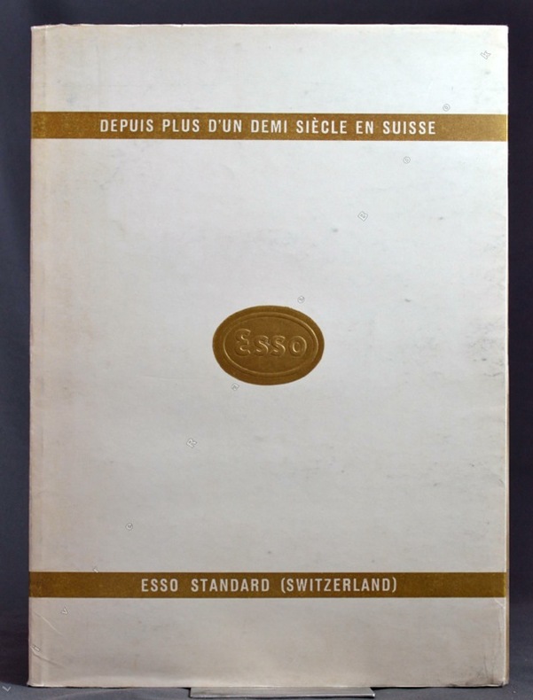
RAAFLAUB A.; WAHLEN F.-T.; WEHRIL B.:
Le livre ESSO. Depuis plus d'un demi-siècle en Suisse.
Sans lieu, ESSO Standard Switzerland, sans date. In-4 broché de 76-[4] pages, couverture blanche et or, titre et logo ESSO dorés au premier plat.
Riferimento per il libraio : 9689
|
|
|
RACHEWILTZ Boris de
Eros noir, moeurs sexuelles de l'Afrique, de la préhistoire à nos jours.
Paris La Jeune Parque 1963 In-8 broché, couverture illustrée
Riferimento per il libraio : 010154
|
|
|
RACINE Roland
Lyon, 1914-1918 : mémoire en images.
Sutton Mémoires en Images 2015 Editions Sutton, Coll. Mémoires en Images, 2015, 192 p., broché, quelques frottements d'usage sur les bords de la couverture, bon état pour le reste et intérieur propre.
Riferimento per il libraio : 111839
|
|
|
Rademaker, Abraham
De Vechtstroom Van Utrecht Tot Muiden
Foresta 24 x 18 Groningen Verheerlykt Door Honderd Gezichten Van Steden, Dorpen, Vestingen, Adelyke Gestigten, Lustplaatzen En Waranden. Broché, format à l'italienne. Facsimilé reprint (ca. 1970) de l'édition d'Amsterdam de 1791 "by Gartman, W Vermandel en J. W. Smit". Recueil de 98 reproductions de gravures d'Abraham Rademaker (sous-titrées en français et en néerlandais) regroupant le plan d'Utrecht et des vues de résidences aristocratiques, de quartiers, de jardins, de villages.Couverture légèrement défraichie, coins légèrement cormés, petite déchirure au bas du dos, mais très bon exemplaire.(C21) Livre
Riferimento per il libraio : 631
|
|
|
Rademaker, Abraham
Hollands Arcadia, Of de vermaarde Rivier den Amstel
Foresta 24 x 18 Groningen Vertonende alle deszelfs Lustplaatzen, Herenhuizen en Dorpen; zig uitstrekkende van Amsterdam af door Ouderkerk, Abcoude, Baembrug tot Loendersloot; Wederkerende langs de vermakelyke Landgezichten Van den Wetering. Broché, format à l'italienne. Facsimilé reprint (1970) de l'édition d'Amsterdam de 1791 "by Gartman, W Vermandel en J. W. Smit". Recueil de 100 reproductions de gravures d'Abraham Rademaker (sous-titrées en français et en néerlandais) de villages, de maisons de plaisance ou de campagnes, de jardins.Couverture légèrement défraichie, coins légèrement cormés, mais très bon exemplaire.(C34) Livre
Riferimento per il libraio : 903
|
|
|
Rademaker, Abraham
Hollands Arcadia, Of de vermaarde Rivier den Amstel
Foresta 24 x 18 Groningen Vertonende alle deszelfs Lustplaatzen, Herenhuizen en Dorpen; zig uitstrekkende van Amsterdam af door Ouderkerk, Abcoude, Baembrug tot Loendersloot; Wederkerende langs de vermakelyke Landgezichten Van den Wetering. Broché, format à l'italienne. Facsimilé reprint (1970) de l'édition d'Amsterdam de 1791 "by Gartman, W Vermandel en J. W. Smit". Recueil de 100 reproductions de gravures d'Abraham Rademaker (sous-titrées en français et en néerlandais) de villages, de maisons de plaisance ou de campagnes, de jardins.Couverture légèrement défraichie, coins légèrement cormés, mais très bon exemplaire.(C34) Livre
Riferimento per il libraio : 903
|
|
 Ricevere i risultati per e-mail
 Scaricare i risultati in PDF
 RSS feed


