|
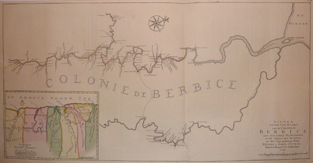
OTTENS (Reinier & Josua);
[GUYANE BRITANNIQUE] Nieuwe gemeten kaart van de colonie de Berbice met der zelver plantagien en de namen der bezitters in het ligt gebragt.
Amsterdam Reinier & Josua Ottens 1740 En deux feuilles jointes de 488 x 959 mm.
書籍販売業者の参照番号
: LBW03935
|
|
|
OUELLETTE, William
CARTES FANTASQUES
Paris Henri Veyrier 1975 in 4 oblong (30 X24) 1 volume broché, 87 pages, avec plus de 250 reproductions en couleurs et en noir et blanc de cartes postales de la belle époque. Bel exemplaire ( Photographies sur demande / We can send pictures of this book on simple request )
書籍販売業者の参照番号
: 16913
|
|
|
Ouellette William
Cartes fantasques
Henri Veyrier Dos carré collé 1975 In-4 (30 x 24 cm), format italien, dos carré collé, 61 pages, illustrations en couleur et noir et blanc ; coiffes et bords des plats frottés, pliure sur le quatrième plat, état moyen. Livraison a domicile (La Poste) ou en Mondial Relay sur simple demande.
書籍販売業者の参照番号
: dz668
|
|
|
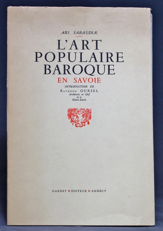
OURSEL Raymond:
L'Art populaire baroque en Savoie.
Annecy, Gardet, coll. Ars Sabaudiae, 1955. Plaquette in-8 de 21-[3] pages, suivie des planches volantes, le tout sous chemise imprimée en deux tons.
書籍販売業者の参照番号
: 13645
|
|
|
OUTHIER (Réginald, abbé).
Carte topographique du diocèse de Sens divisé en ses cinq archidiaconés et ses douze doyennés.
Sens, André Jannot, et Paris, Ve Mazieres et J. Bap.te Garnier, 1741. En deux feuilles jointes de 725 x 870 mm.
書籍販売業者の参照番号
: LBW-426

|
|
|
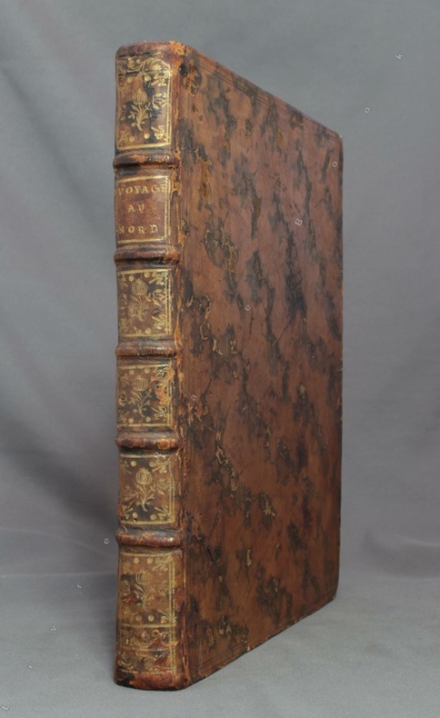
OUTHIER [Abbé Réginald]:
Journal d'un voyage au Nord, en 1736 & 1737.
Paris, Piget; Durand, 1744. In-4 de [8]-238-[2] pages, plein veau marbré brun, dos à nerfs orné de filets et fleurons dorés, pièce de titre brune, tranches rouges.
書籍販売業者の参照番号
: 8781
|
|
|
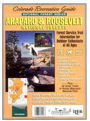
Outdoor Books & Maps
Arapaho & Roosevelt National Forest Colorado All-Activities Guidebook
2013-06-06. New. Ships with Tracking Number! INTERNATIONAL WORLDWIDE Shipping available. May be re-issue. Buy with confidence excellent customer service! unknown
書籍販売業者の参照番号
: 0930657578n ISBN : 0930657578 9780930657574

|
|
|
Outdoor Books and Maps Inc. Staff
Arapaho and Roosevelt National Forest Recreation Guide
Adler Publishing Company 1998. Paperback. Acceptable. Disclaimer:A readable copy. All pages are intact and the cover is intact. Pages can include considerable notes-in pen or highlighter-but the notes cannot obscure the text. At ThriftBooks our motto is: Read More Spend Less.Dust jacket quality is not guaranteed. Adler Publishing Company paperback
書籍販売業者の参照番号
: G093065708XI5N00 ISBN : 093065708X 9780930657086
|
|
|
Outdoor Books and Maps
Best of Northern Colorado Hiking Trails
Adler Publishing Company 1998. Paperback. Acceptable. Disclaimer:A readable copy. All pages are intact and the cover is intact. Pages can include considerable notes-in pen or highlighter-but the notes cannot obscure the text. At ThriftBooks our motto is: Read More Spend Less.Dust jacket quality is not guaranteed. Adler Publishing Company paperback
書籍販売業者の参照番号
: G0930657187I5N00 ISBN : 0930657187 9780930657185

|
|
|
Outdoor Books & Maps
Best of Northern Colorado Hiking Trails
Outdoor Books & Maps 1995-01-01. Revised. Paperback. Used:Good. Outdoor Books & Maps paperback
書籍販売業者の参照番号
: DADAX0930657187 ISBN : 0930657187 9780930657185

|
|
|
Outdoor Books & Maps
Best of Northern Colorado Hiking Trails: 78 Hiking Trails to Scenic & Historical Sites
Outdoor Books and Maps. Used - Good. Shows some signs of wear and may have some markings on the inside. 100% Money Back Guarantee. Shipped to over one million happy customers. Your purchase benefits world literacy! Outdoor Books and Maps unknown
書籍販売業者の参照番号
: GRP65016947 ISBN : 0930657187 9780930657185
|
|
|
Outdoor Books & Maps
Best of Northern Colorado Hiking Trails
Outdoor Books and Maps 1995. Paperback. Good. Outdoor Books and Maps paperback
書籍販売業者の参照番号
: SONG0930657187 ISBN : 0930657187 9780930657185
|
|
|
Outdoor Books & Maps
Best of Rocky Mountain National Park Hiking Trails
Outdoor Books & Maps. Used - Good. Ships from Reno NV. Shows some signs of wear and may have some markings on the inside. 100% Money Back Guarantee. Shipped to over one million happy customers. Your purchase benefits world literacy! Outdoor Books & Maps unknown
書籍販売業者の参照番号
: GRP111806715 ISBN : 093065739x 9780930657390
|
|
|
Outdoor Books & Maps
Best of Rocky Mountain National Park Hiking Trails
Outdoor Books & Maps 1998-07-01. Revised. Paperback. Used:Good. Outdoor Books & Maps paperback
書籍販売業者の参照番号
: DADAX093065739X ISBN : 093065739X 9780930657390
|
|
|
Outdoor Books & Maps
Best of Rocky Mountain National Park Hiking Trails
Outdoor Books & Maps 1998-07-01. Paperback. Good. Outdoor Books & Maps paperback
書籍販売業者の参照番号
: SONG093065739X ISBN : 093065739X 9780930657390
|
|
|
Outdoor Books & Maps
Best of Western Colorado Hiking Trails
Outdoor Books & Maps 1998-01-01. Paperback. Good. Outdoor Books & Maps paperback
書籍販売業者の参照番号
: SONG0930657179 ISBN : 0930657179 9780930657178
|
|
|
Outdoor Books & Maps
Colorado 4-Wheel Drive Roads Revised Edition
Outdoor Books & Maps. Used - Like New. Used - Like New. Book is new and unread but may have minor shelf wear. Ships from UK in 48 hours or less usually same day. Your purchase helps support the African Children's Educational Trust A-CET. 100% money back guarantee. We are a world class secondhand bookstore based in Hertfordshire United Kingdom and specialize in high quality textbooks across an enormous variety of subjects. We aim to provide a vast range of textbooks rare and collectible books at a great price. Through our work with A-CET we have helped give hundreds of young people in Africa the vital chance to get an education. We provide a 100% money back guarantee and are dedicated to providing our customers with the highest standards of service in the bookselling industry. Outdoor Books & Maps unknown
書籍販売業者の参照番号
: Z1-U-039-00924 ISBN : 0930657403 9780930657406

|
|
|
Outdoor Books & Maps
Colorado 4-Wheel Drive Roads Revised Edition
2007-01-01. New. Ships with Tracking Number! INTERNATIONAL WORLDWIDE Shipping available. May be re-issue. Buy with confidence excellent customer service! unknown
書籍販売業者の参照番号
: 0930657403n ISBN : 0930657403 9780930657406

|
|
|
Outdoor Books & Maps
Colorado 4-Wheel Drive Roads Revised Edition
Outdoor Books & Maps 2007-05-15. Revised. Paperback. Used:Good. Outdoor Books & Maps paperback
書籍販売業者の参照番号
: DADAX0930657403 ISBN : 0930657403 9780930657406
|
|
|
Outdoor Books & Maps
Colorado 4-Wheel Drive Roads Revised Edition
Outdoor Books & Maps 2007-05-15. Paperback. Good. Outdoor Books & Maps paperback
書籍販売業者の参照番号
: SONG0930657403 ISBN : 0930657403 9780930657406
|
|
|
Outdoor Books and Maps
Colorado Biking Trails
Adler Publishing Company 2007. Paperback. Good. Disclaimer:A copy that has been read but remains in clean condition. All pages are intact and the cover is intact. The spine may show signs of wear. Pages can include limited notes and highlighting and the copy can include previous owner inscriptions. At ThriftBooks our motto is: Read More Spend Less.Dust jacket quality is not guaranteed. Adler Publishing Company paperback
書籍販売業者の参照番号
: G0930657284I3N00 ISBN : 0930657284 9780930657284

|
|
|
Outdoor Books and Maps
Colorado Biking Trails
Adler Publishing Company 2007. Paperback. Acceptable. Disclaimer:A readable copy. All pages are intact and the cover is intact. Pages can include considerable notes-in pen or highlighter-but the notes cannot obscure the text. At ThriftBooks our motto is: Read More Spend Less.Dust jacket quality is not guaranteed. Adler Publishing Company paperback
書籍販売業者の参照番号
: G0930657284I5N00 ISBN : 0930657284 9780930657284

|
|
|
Outdoor Books & Maps
Colorado Biking Trails
2007-03-08. New. Ships with Tracking Number! INTERNATIONAL WORLDWIDE Shipping available. May be re-issue. Buy with confidence excellent customer service! unknown
書籍販売業者の参照番号
: 0930657284n ISBN : 0930657284 9780930657284

|
|
|
Outdoor Books & Maps
Colorado Biking Trails
Outdoor Books & Maps. Used - Good. Shows some signs of wear and may have some markings on the inside. Outdoor Books & Maps unknown
書籍販売業者の参照番号
: GRP78777057 ISBN : 0930657284 9780930657284

|
|
|
Outdoor Books & Maps
Colorado Biking Trails
Outdoor Books & Maps 2007-05-31. 4th. Paperback. Used:Good. Outdoor Books & Maps paperback
書籍販売業者の参照番号
: DADAX0930657284 ISBN : 0930657284 9780930657284
|
|
|
Outdoor Books & Maps
Colorado Biking Trails
Outdoor Books & Maps 2007-05-31. Paperback. Good. Outdoor Books & Maps paperback
書籍販売業者の参照番号
: SONG0930657284 ISBN : 0930657284 9780930657284
|
|
|
Outdoor Books & Maps
Colorado Campgrounds
2010-04-01. New. Ships with Tracking Number! INTERNATIONAL WORLDWIDE Shipping available. May be re-issue. Buy with confidence excellent customer service! unknown
書籍販売業者の参照番号
: 0930657551n ISBN : 0930657551 9780930657550

|
|
|
Outdoor Books & Maps
Colorado Campgrounds
Adler Publishing 2010-07-19. 12th. Perfect Paperback. Used:Good. Adler Publishing paperback
書籍販売業者の参照番号
: DADAX0930657551 ISBN : 0930657551 9780930657550
|
|
|
Outdoor Books & Maps
Colorado Campgrounds
Adler Publishing 2010-07-19. Perfect Paperback. Good. Adler Publishing paperback
書籍販売業者の参照番号
: SONG0930657551 ISBN : 0930657551 9780930657550
|
|
|
Outdoor Books & Maps
Colorado Fishing
Adler Publishing Company 2011. Perfect Paperback. Acceptable. Disclaimer:A readable copy. All pages are intact and the cover is intact. Pages can include considerable notes-in pen or highlighter-but the notes cannot obscure the text. At ThriftBooks our motto is: Read More Spend Less.Dust jacket quality is not guaranteed. Adler Publishing Company paperback
書籍販売業者の参照番号
: G0930657586I5N00 ISBN : 0930657586 9780930657581

|
|
|
Outdoor Books & Maps
Colorado Fishing
2011-05-02. New. Ships with Tracking Number! INTERNATIONAL WORLDWIDE Shipping available. May be re-issue. Buy with confidence excellent customer service! unknown
書籍販売業者の参照番号
: 0930657586n ISBN : 0930657586 9780930657581

|
|
|
Outdoor Books & Maps Firm
Colorado Fishing Guide: Located 100 Colorado Stocked Lakes Reservoirs And 168 Rivers
Outdoor Books & Maps. Used - Good. Shows some signs of wear and may have some markings on the inside. Outdoor Books & Maps unknown
書籍販売業者の参照番号
: GRP83717259 ISBN : 0930657306 9780930657307
|
|
|
Outdoor Books & Maps
Colorado Fishing
Adler Publishing 2011-08-01. Sixth. Perfect Paperback. Used:Good. Adler Publishing paperback
書籍販売業者の参照番号
: DADAX0930657586 ISBN : 0930657586 9780930657581

|
|
|
Outdoor Books & Maps
Colorado Fishing Guide to Stocked Lakes Reservoirs & Rivers Map
Outdoor Books and Maps 1999-04. Map. Good. Outdoor Books and Maps unknown
書籍販売業者の参照番号
: SONG0930657306 ISBN : 0930657306 9780930657307
|
|
|
Outdoor Books & Maps
Colorado Lakes & Reservoirs: Fishing and Boating Guide
Outdoor Books & Maps. Used - Good. Shows some signs of wear and may have some markings on the inside. Outdoor Books & Maps unknown
書籍販売業者の参照番号
: GRP93229417 ISBN : 0930657543 9780930657543

|
|
|
Outdoor Books & Maps
Colorado Lakes & Reservoirs: Fishing and Boating Guide
Outdoor Books & Maps 2008-07-15. 9th. Perfect Paperback. Used:Good. Outdoor Books & Maps paperback
書籍販売業者の参照番号
: DADAX0930657543 ISBN : 0930657543 9780930657543
|
|
|
Outdoor Books & Maps Firm
Colorado Lakes & Reservoirs Guide: Fishing and Boating Guide
Outdoor Books and Maps 2001-06. Paperback. Good. Outdoor Books and Maps paperback
書籍販売業者の参照番号
: SONG0930657004 ISBN : 0930657004 9780930657000

|
|
|
Outdoor Books & Maps
Colorado Lakes & Reservoirs: Fishing and Boating Guide
Outdoor Books & Maps 2008-07-15. Perfect Paperback. Good. Outdoor Books & Maps paperback
書籍販売業者の参照番号
: SONG0930657543 ISBN : 0930657543 9780930657543
|
|
|
Outdoor Books & Maps
Colorado's Guide to Hunting
1999-10-25. Good. Ships with Tracking Number! INTERNATIONAL WORLDWIDE Shipping available. May not contain Access Codes or Supplements. May be re-issue. May be ex-library. Shipping & Handling by region. Buy with confidence excellent customer service! unknown
書籍販売業者の参照番号
: 093065742X ISBN : 093065742x 9780930657420

|
|
|
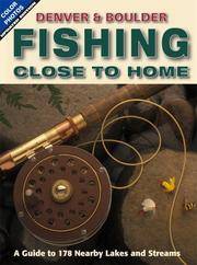
Outdoor Books & Maps
Denver & Boulder Fishing Close to Home
Outdoor Books & Maps 2007-05-31. 4th. Paperback. Used:Good. Outdoor Books & Maps paperback
書籍販売業者の参照番号
: DADAX0930657519 ISBN : 0930657519 9780930657512
|
|
|
Outdoor Books & Maps
Denver & Boulder Fishing Close to Home
Outdoor Books & Maps 2007-05-31. Paperback. Good. Outdoor Books & Maps paperback
書籍販売業者の参照番号
: SONG0930657519 ISBN : 0930657519 9780930657512
|
|
|
Outdoor Books & Maps Firm
Fishing Close to Home
Outdoor Books and Maps 1996-03. Paperback. Good. Outdoor Books and Maps paperback
書籍販売業者の参照番号
: SONG0930657055 ISBN : 0930657055 9780930657055
|
|
|
Outdoor Books & Maps
Pike National Forest: Trail Information for Any Age Group and Skill Level Colorado Recreation Guide National Forest Series
Outdoor Books and Maps 1998-01-01. Paperback. Good. Outdoor Books and Maps paperback
書籍販売業者の参照番号
: SONG093065711X ISBN : 093065711X 9780930657116

|
|
|
Outdoor Books & Maps
Rio Grande National Forest Recreation Guide National forest series
Outdoor Books & Maps 1996-08-01. Paperback. Used:Good. Outdoor Books & Maps paperback
書籍販売業者の参照番号
: DADAX0930657152 ISBN : 0930657152 9780930657154

|
|
|
Outdoor Books & Maps
Routt National Forest Recreation Guide National Forest Series
Outdoor Books & Maps 1996-05-01. Paperback. Used:Good. Outdoor Books & Maps paperback
書籍販売業者の参照番号
: DADAX0930657128 ISBN : 0930657128 9780930657123

|
|
|
Outdoor Books & Maps
Routt National Forest Recreation Guide National Forest Series
Outdoor Books & Maps 1996-05-01. Paperback. Used:Good. Outdoor Books & Maps paperback
書籍販売業者の参照番号
: SONG0930657128 ISBN : 0930657128 9780930657123
|
|
|
Outdoor Books & Maps
San Isabel National Forest Recreation Guide National Forest Series
1995-08-07. New. Ships with Tracking Number! INTERNATIONAL WORLDWIDE Shipping available. May be re-issue. Buy with confidence excellent customer service! unknown
書籍販売業者の参照番号
: 0930657144n ISBN : 0930657144 9780930657147

|
|
|
Outdoor Books & Maps
San Isabel National Forest Recreation Guide National Forest Series
Outdoor Books & Maps 1995-05-01. Revised 2000. Paperback. Used:Good. Outdoor Books & Maps paperback
書籍販売業者の参照番号
: DADAX0930657144 ISBN : 0930657144 9780930657147

|
|
|
Outdoor Books & Maps
San Isabel National Forest Recreation Guide National Forest Series
Outdoor Books & Maps 1995-05-01. Paperback. Used:Good. Outdoor Books & Maps paperback
書籍販売業者の参照番号
: SONG0930657144 ISBN : 0930657144 9780930657147
|
|
|
Outdoor Books & Maps
San Juan National Forest Colorado All-Activities Guidebook
2012-07-02. Good. Ships with Tracking Number! INTERNATIONAL WORLDWIDE Shipping available. May not contain Access Codes or Supplements. May be re-issue. May be ex-library. Shipping & Handling by region. Buy with confidence excellent customer service! unknown
書籍販売業者の参照番号
: 0930657594 ISBN : 0930657594 9780930657598

|
|
 検索結果のメールを受信する
 PDFファイルの検索結果をダウンロード
 RSSフィード


