|
|
|
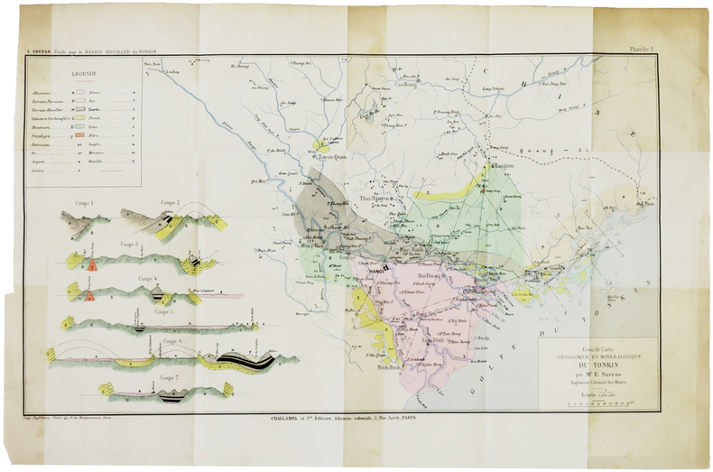
SARRAN (Émile).
[GÉOLOGIE/TONKIN] Essai de carte géologique et minéralogique du Tonkin.
[1888]. 243 x 433 mm.
书商的参考编号 : LBW-5005
|
|
|
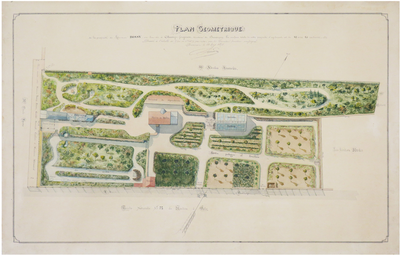
SARRAZIN (E. C.).
[DOUBS] Plan géométrique de la propriété de Monsieur Bossy, sise lieu-dit à Champ-Forgeron, territoire de Besançon.
1875. 45 x 70 cm ; monté sur carton fort.
书商的参考编号 : LBW-7429
|
|
|
SARTIAUX Félix
Villes Mortes D'Asie Mineure Pergame, Ephese, Priene, Milet, Le Didymeion, Hierapolis.
1911 à Paris , chez Hachette , in-8 (200x130),relié pleine toile ,233pp avec 40 vues photographiques Hors texte prises par l'auteur ,3 reproductions de monuments, 8 cartes et plans .
书商的参考编号 : PHO-926
|
|
|
SATIRICAL MAPS/CARICATURAL MAPS
Karte von Europa im Jahre 1870 nach einem franzosischen Holzschnitte - Paul Hadol / Karte von Europa im Jahre 1914 - Walter Trier. Two satirical maps on one sheet.
Berlin: Druck: Reklameverlag Ernst Marx Berlin 1914. The two maps were issued in 1914 next to each other on one sheet measuring 94 x 36 cm reinforced with a linen coating on the backside. MAP 1.Karte von Europa im Jahre 1870. Nice example of the German edition of Paul Hadol's satirical political cartoon map of Europe showing countries personified in caricature and alluding to the tensions that finally erupted as the Franco-Prussian War in July 1870. One of the earliest political satire Serio-Comic maps Hadol's map was originally published in French and later copied in English German and Dutch. With captions in French and German at the foot of the map explaining the symbolic images used. IMAGES MAP 1: Prussia made to look like its walrus-bearded �Iron Chancellor� Otto von Bismarck is haranguing its neighbours: kneeling on Austria a sleeping soldier in undress; covering the Netherlands with its right hand. France dressed as a fierce zouave soldier is aiming a bayonet at the heart of the unwieldy Prussian military monster. Belgium too small to be anthropomorphised is being squeezed between France and Prussia which would become its familiar if uncomfortable lot in the First and Second World Wars. England is an old woman struggling with Ireland her rebellious lapdog on a leash although it looks more like a small bear; Scotland is the old lady�s mobcap. Spain is a rotund senorita smoking the day away while lying on her back and thus nearly crushing the small Portuguese soldier under her. Corsica and Sardinia are joined to show a leprechaun-like figure gleefully mooning the map-reader. Italy possibly made to look like the great national leader Garibaldi is holding off pressure from Prussia. Denmark is a small swaggering soldier no doubt hoping to recover the territory it lost to Prussia in a war a few years earlier. � Norway and Sweden together are turned into a ferocious dog. � Switzerland is a closed cottage. � Turkey in Europe is �an Oriental crushed by the superincumbent pressure of the other countries�. � Turkey in Asia is a girl smoking a hookah pipe. � Russia is a rag-collector in a patched coat �Crimea� written on the patch sewn on last. The Degrees of Longitude at the bottom of the map are measured in rifle-lengths � another comment on the explosive military situation. MAP 2. Karte von Europa im Jahre 1914. Drawing by WalterTrier. With captions at the foot of the map in German. IMAGES MAP 2. Full text: England hides its fleet under the skirt of home the dog Ireland is at its back- King Oskar of Sweden looks intently at Russia. - France bravely retreats while Spain devotes itself to sweet idleness.- Belgium already has! - German and Austria-Hungary strike solid German blows on all sides.- Good "will" prevails in Switzerland.- Blacked out taly is loyal until death or victory - Sicily volcanic soil but otherwise quite quiet.- Montenegro a pack of lice.- Serbia a pack of swine! The King of Durazzo.- Albania abandons its people.- Greece and Turkey are eager to devour one another.- Ferdinand of Bulgaria would also like to have a share.- Blacked out Carolus of Rumania - Russia wants to swallow up everything but will not succeed. IN GOOD CONDITION. 94 x 36 cm. Druck: Reklameverlag Ernst Marx, Berlin unknown
书商的参考编号 : 7318
|
|
|
Saul, John C.: Editor
A Complete Geography: Tarr and McMurry's Geographies
506 pages. Lovely vintage geography textbook authorized for use in the public schools of Manitoba. Many black and white photos plus lovely fold-out, double-hinged colour maps of Canadian provinces, regions of the U.S., and other areas of the world. Front free endpaper removed. Somewhat above-average wear. Binding somewhat shaken but still intact. The vintage illustrations make this volume a treat to peruse. Book

|
|
|
SAUSSINE (Léon).
Game of the skating-rink – Jeu du skating-rink.
Paris, Saussine, [entre 1876 et 1880]. 526 x 695 mm, sur papier à l'aspect glacé.
书商的参考编号 : LBW-8543

|
|
|
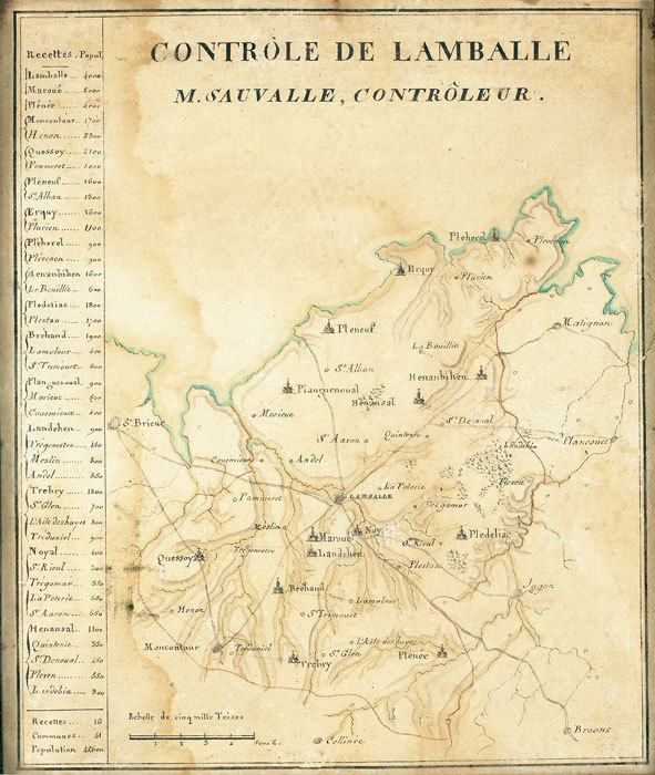
SAUVALLE. MANUSCRIT.
Contrôle de Lamballe. M. Sauvalle, contrôleur.
[fin XVIIIe]. 218 x 180 mm.
书商的参考编号 : LBW-784
|
|
|
Savander O. Sederholm J. J. Saliskapet for Finlands geografi. Neovius Eduard Rudolf.
ATLAS OFVER FINLAND.
Helsingfors: Aktiebolaget F. Tilgmanns Bok-Och Stentryckeri 1899. First Edition. Hardcover. Very Good. Charts. Octavo quarter calf various paginations. Scarce: not uncommonly found separately from the atlas volume. <br/><br/>This is the Text volume only which was designed to accompany the 70 leaves of maps in the Atlas volume. This volume contains about forty essays by various experts about the maps. . Illustrated with 10 plates 84 figures charts graphs. Aktiebolaget F. Tilgmanns Bok-Och Stentryckeri hardcover
书商的参考编号 : 004976
|
|
|
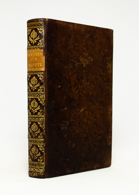
Savary (Claude-Etienne) :
Lettres sur l’Egypte, où l’on offre le parallèle des mœurs anciennes et modernes de ses habitans, où l’on décrit l’état, le commerce, l’agriculture, le gouvernement, l’ancienne religion du pays, et la descente de S. Louis à Damiette, tirée de Joinville et des Auteurs Arabes, avec des Cartes Géographiques. Seconde édition revue et corrigée.
Paris, Onfroi, 1786 ; 3 tomes in-8 ; demi-veau havane, dos à faux-nerfs décoratifs et pièces de titre et tomaison vieux-rouge, tranches mouchetées ; IV, 351 ; 308 ; 308 pp. et 4 planches dépliantes dont 3 cartes géographiques.
书商的参考编号 : 16502
|
|
|
SAVARY Claude-Etienne:
Lettres sur l'Egypte, où l'on offre le parallèle des moeurs anciennes & modernes et de ses habitans, où l'on décrit l'état, le commerce, l'agriculture, le gouvernement du pays, la descente de S. Louis à Damiette, tirée de Joinville des Auteurs arabes, avec des Cartes Géographiques.
Paris, Chez Onfroi, 1785, 1786. 3 volumes in-8 de X-395-[3]; [2]-310; [2]-310 pages. plein veau moucheté brun, dos à nerfs ornés de filets et fleurons dorés, pièces de titre et tomaison beige, tranches rouges.
书商的参考编号 : 19222
|
|
|
SAVARY Claude:
Lettres sur l'Egypte...
Paris, chez Onfroi, 1785. In-8 de [4]-IV-351 pages, pleine basane blonde, dos lisse orné de fleurons à la grenade et écoinçons végétaux, pièce de titre en cuir sable, filet simple et double estampés à froid en encadrement des plats, tranches rouges.
书商的参考编号 : 18486
|
|
|
SAVERNE
Carte allemande au 1/80 000?. Fin XIXe.
1 feuille repli?e. 31,5x45 cm.
|
|
|
Savigny (G.-B. de)
Traité complet des jeux de cartes. Règles détaillées des Grands Cercles, commentaires sur la science des jeux, calcul des probabilités.
français Sans date. Fort in-12 de 538 pp.; broché de l'éditeur (plats de couverture renforcés de carton). Avec de nombreuses illustrations explicatives dans le texte. Petits transferts de scotch dans la première et dernière pages.
|
|
|
SAVIGNY (G.-B.)
L'Ecarté - Règles complètes et raisonnées des grands cercles - Probabilités et Science du jeu
Paris, Albin Michel, s.d. (1951?). In-12 broché vert, 92 p. Bon état.Le rams - Le bésigue - La mouche - Le mariage - Le polignac.
书商的参考编号 : 5651
|
|
|
SAVIGNY (G.-B.)
La Manille - Règles complètes et séparées de tous les Jeux de Manille
Paris, Albin Michel, 1951. In-12 broché vert, non coupé, 92 p. Nombreuses vignettes in-t. Contient : Manille parlée - Manille muette - Le Dix-Sept Manille à trois avec un mort - Manille à l'envers - Les Manilles aux enchères, simples et composées - Manille de misère - Manille à deux. Calcul des probabilités - Etude des coups. Très bon état malgré qq. rousseurs.
书商的参考编号 : 5652
|
|
|
SAVIGNY G B (de)
La Manille règles complètes et séparées de tous les jeux de manille avec le calcul de probabilité et l’étude des coups difficiles,
in 12 broché couverture illustrée,94 pages,vignettes dans le texte Albin Michel éditeur sans date (1951)Manille parlée-Manille muette-Le dix-sept Manille à trois avec un mort-Manille à l'envers-Les Manilles aux enchères,simples et composées-Manille de misère-Manille à deux-Etude des coups
书商的参考编号 : 3080
|
|
|
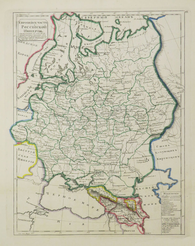
SAVINKOV (Aleksandr Dmitrievich).
[Carte de la Russie].
[St. Pétersbourg, 1835]. 291 x 231 mm.
书商的参考编号 : LBW-3684
|
|
|
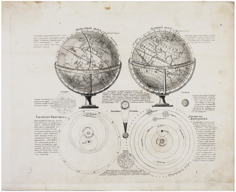
SAVINKOV (Aleksandr Dmitrievich).
[SPHÈRES].
[St. Pétersbourg, 1835]. 215 x 255 mm.
书商的参考编号 : LBW-6181
|
|
|
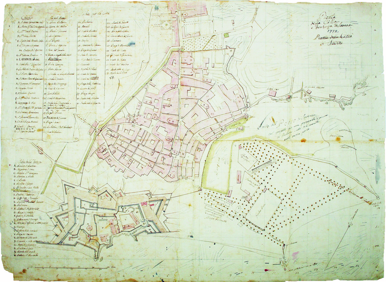
SAVONE. MANUSCRIT.
Pianta della città e fortezza di Savona.
1772. En 2 feuilles jointes de 535 x 700 mm.
书商的参考编号 : LBW-4233
|
|
|
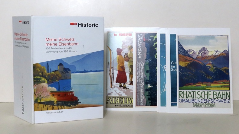
SBB-CFF:
Meine Schweiz, meine Eisenbahn. 100 cartes postales.
Fondation du patrimoine historique des CFF / Stiftung Historisches Erbe der SBB. Coffret illustré contenant 100 cartes postales. A l'état de neuf. Texte sur le coffret en allemand.
书商的参考编号 : 22927
|
|
|
Scandinavia in Old Maps and Prints
Mingroot Erik van - Ermen Eduard van
Mappamundi Belgium 1987. 144 sidor. Rikligt illustrerad med kartor i f�rg. F�rsta och sista uppslaget illustrerade med kartor. F�rlagets m�rkbl� klotband med p�rm- och ryggtext i guld och skyddsomslag. 385x31 cm. Bra skick. Originaltitel: Zweden en de skandinavische landen in kaart en prent. Translation: Tony Mackrill Marc Hutsebaut. Engelsk text. Reproduktioner av 74 kartor och vyer fr�n Danmark Finland Norge Island F�r�arna och Sverige i kronologisk ordning fr�n ca 1580 till slutet av 1700-talet. English text. 1 18485 unknown
书商的参考编号 : Kartor - Maps | Danmark F
|
|
|
SCARPE. MANUSCRIT.
Carte particulière des rivières de la Scarpe, de l'Escaut et de ses canaux y afluant depuis Douay et Bouchain jusqu'à leur jonction à Mortagne.
[circa 1780]. En 16 sections montées sur toile et pliées, formant une carte de 0,77 x 1,03 m.
书商的参考编号 : LBW-2820

|
|
|
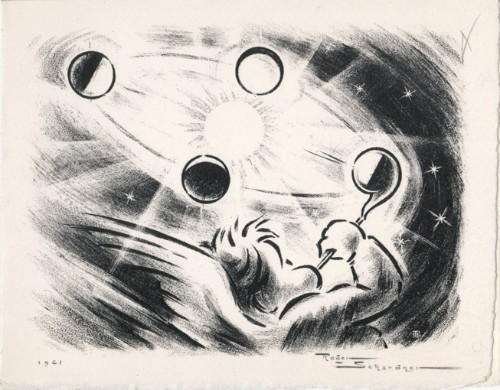
Schardner, Roger
Roger Schardner : carte de voeux pour 1961 et gravure originale
1961 Carte de voeux de Roger Schardner et Madame pour l'année 1961. 12 x 15 cm, 2ff., portant une gravure en noir signée et datée en page 1 et les voeux finement calligraphiés à la mine de plomb à l'attention de M. le député Michel Boscher.
书商的参考编号 : 1478
|
|
|
SCHAUENBURG (Balthasar Alexis Henri Antoine de) - ENGELBERTS (Derck C. E.) dir.
Die Schauenburg-Sammlung der Eidgenössischen Militärbibliothek und des Historischen Dienstes. Beitrag zur Geschichte der Schweiz anhand von Karten des 17. und 18 Jahrhunderts. Hrsg. von Derck C. E. Engelberts- Texte von Prof. Dr. Georges Grosjean. - Alain F. Berlincourt - Derck C.E. Engelberts - Stuart Morgan - Dominic M. Pedrazzini.
Hauterive, Editions Gilles Attinger, 1989, elefant-Folio: 59 x 75 cm (Kassette). Papiergrösse 56 x 71 cm. 127 lose faksimilierte, farbige Blätter in 59 bedruckten Papierhüllen, leinen-überzogene Kassette, Lederetikette vorne, Verschluss mit 2 Lederriemen und Druckknöpfen.
书商的参考编号 : 127536aaf
|
|
|
SCHEDEL Hartmann (Norimberga 1440 - ivi 1514)
Roma
Veduta panoramica della città tratta dal celebre Liber Cronicarum del 1493."E' la più nota immagine di Roma data alle stampe alla fine del '400. Essendo stata inserita nella fortunatissima opera di Hartman Schedel comunemente nota con il nome di Cronaca di Norimberga può dirsi senz'altro comune. Si tratta di una derivazione dal prototipo comune a tutte le piante medioevali di Roma e noto come panorama di Mantova, a sua volta ripreso da un presunto ma tuttora sconosciuto panorama inciso nella bottega di Francesco Rosselli verso il 1485. La città è vista da nord-est a volo dìuccello per porre in evidenza la zona Vaticana oggetto di vari lavori tra cui le spine di Borgo, il Belvedere (1485/87), il Santo Spirito ed il palazzo del Papa. Sono inoltre riconoscibili le realizzazioni di Santa Maria del Popolo e ponte Sisto. Tra le antichità spiccano il Pantheon, il Colosseo, la colonna Antonina ed in primo piano i Dioscuri nella originaria collocazione presso le terme di Diocleziano. Manca curiosamente l'Isola Tiberina" (cfr. Marigliani p. 117).La monumentale opera di Schedel, il Liber Cronicarum, rappresenta uno “dei più straordinari lavori mai realizzati” dall’editoria del XV secolo. Gli incisori erano Michael Wolgemut, famoso maestro di Albrecht Dürer, e il figliastro Wilhelm Pleydenwurff. Wolgemut fu il tutore di Albrecht Dürer tra il 1486 e il 1490; recenti studi hanno dimostrato come Durer abbia collaborato alla realizzazione di quest’opera, poiché alcuni dei tratti hanno somiglianze stupefacenti con quelli dell’Apocalisse; alcune opere sono infatti attribuite al maestro di Norimberga. La stampa venne supervisionata dal grande stampatore Anton Koberger, le cui opere erano famose in tutta Europa. Xilografia, finemente colorata a mano, consuete tracce di restauro alla piega centrale, nel complesso in ottimo stato di conservazione.BibliografiaA. P. Frutaz, "Le piante di Roma", XCVI; C. Marigliani, "Le Piante di Roma delle collezioni private", n. 8; M. Gori Sassoli (a cura di), "Roma Veduta" p. 139, n. 5; Scaccia Scarafoni, "Le Piante di Roma", n. 125. It is the most famous image of Rome given to the prints at the end of '400. Having been inserted in the very fortunate work of Hartman Schedel commonly known with the name of Chronicle of Nuremberg can be said without doubt common. It is a derivation from the prototype common to all the medieval map of Rome and known as the Mantua panorama, in turn taken from a presumed but still unknown panorama engraved in the workshop of Francesco Rosselli around 1485. The city is seen from the northeast in a bird's eye view to highlight the Vatican area which has been the subject of various works including the Borgo thorns, the Belvedere (1485/87), the Santo Spirito and the Pope's palace. Also recognizable are the realizations of Santa Maria del Popolo and Ponte Sisto. Among the antiquities stand out the Pantheon, the Colosseum, the Antonine column and in the foreground the Dioscuri in the original location near the Baths of Diocletian. The Tiber Island is curiously missing. (see Marigliani p. 117).Schedel's monumental Liber Cronicarum was “one of the most extraordinary works ever produced” The woodblock cutters were Michael Wolgemut, the well-known teacher of Albrecht Dürer, and his stepson Wilhelm Pleydenwurff. Wohlgemut was Albrecht Dürer's tutor between 1486-90 and recent scholarship has shown, Albrecht Dürer may also have collaborated, since some of the cuts bear a remarkably close resemblance to the Apocalypse illustrations. The printing was carried out under the supervision of the great scholar-printer Anton Koberger, whose printing were famous throughout Europe. Woodcut, fine hand colouring, in good condition.BibliografiaA. P. Frutaz, "Le piante di Roma", XCVI; C. Marigliani, "Le Piante di Roma delle collezioni private", n. 8; M. Gori Sassoli (a cura di), "Roma Veduta" p. 139, n. 5; Scaccia Scarafoni, "Le Piante di Roma", n. 125.

|
|
|
SCHEDEL Hartmann (Norimberga 1440 - ivi 1514)
Roma
Veduta fantastica della città posta nella parte inferiore del foglio che contiene anche il testo descrittivo, tratto dal "Liber cronicarum cum figuris et umaginibus ab initio mudi usus mit temporis" rarissima edizione "tascabile" della celebre cronaca del mondo, edita ad Ausburg presso Johann Schonsperger, nel 1496. Prima edizione in tedesco dello Schonsperger. Egli abbrevia sia il testo sia il formato dello Schedel per produrre un edizione che fosse più maneggevole a commerciabile di quella di A. Koberger. "Nel 1469 venne realizzata un'edizione delle Cronaca di Norimberga in formato ridotto a cura di J. Schonsperger in cui le immagini sono copie ridotte di quelle originali ed anche i testi sono sintetizzati. Questa edizione (la seconda in tedesco) è comunque assai più rara della prima. L'editore Schonsperger è noto in quanto impiegò a Norimberga un nuovo carattere gotico chiamato Fraktur nel poema composto per la morte di Massimiliano I" (cfr. Marigliani p. 117).Silografia finemente colorata a mano, in ottimo stato di conservazione. Molto rara.BibliografiaC. Marigliani, "Le Piante di Roma delle collezioni private", n. 10. Fantastic view of the city placed in the lower part of the sheet that also contains the descriptive text, taken from the "Liber cronicarum cum figuris et umaginibus ab initio mudi usus mit temporis", the very rare "pocket edition" of the famous chronicle of the world, published in Ausburg by Johann Schonsperger, in 1496. First German edition of the Schonsperger. He shortened both the text and the format of the Schedel to produce an edition that was more manageable and marketable than that of A. Koberger. "In 1469 an edition of the Chronicle of Nuremberg was produced in reduced format by J. Schonsperger in which the images are reduced copies of the original ones and also the texts are synthesized. This edition (the second one in German) is however much rarer than the first one. The publisher Schonsperger is known because he used in Nuremberg a new gothic character called Fraktur in the poem composed for the death of Maximilian I" (see Marigliani p. 117).Woodcut, with fine later hand colour, excellent condition. Very rare.BibliografiaC. Marigliani, "Le Piante di Roma delle collezioni private", n. 10.

|
|
|
Schedel, Hartmann (1440-1514)
Parisius & Maguncia - Paris und Mainz.
Nürnberg, Anton Koberger, 1493. Kol. Holzschnitt. Blattgrösse: 45 x 62 cm. + Wichtig: Für unsere Kunden in der EU erfolgt der Versand alle 14 Tage verzollt ab Deutschland / Postbank-Konto in Deutschland vorhanden +
书商的参考编号 : 591DG

|
|
|
Schedel, Hartmann (1440-1514):
Parisius & Maguncia - Paris und Mainz.
Nürnberg, Anton Koberger, 1493. Kol. Holzschnitt. Blattgrösse: 45 x 62 cm.
书商的参考编号 : 591DG
|
|
|
Schelbert, Leo (ed.)
Switzerland Under Siege 1939-1945: A Neutral Nation's Struggle for Survival
As new book in excellent condition in every respect. Binding is solid and square, covers have sharp corners, exterior shows no blemishes, text/interior is clean and free of marking of any kind. Many color detailed maps. 247 pages, institutional stamp on front end paper.
|
|
|
Schenk, Peter der Jüngere
Accurate Geographische Charte dar Graeflichen Stolbergl. als Hohnstein, Stolberg, Hayn, Berenroda, Ebersburg, Ufftrungen, Rosla, und Questen nebst unterschiedliche angräntzenden. [Altkolorierter Original-Kupferstich / original colored copper engraving].
o.J. Peter Schenk der Jüngere, geboren am 15. Februar 1693 in Amsterdam, gestorben am 14. Januar 1775 ebenda. Deutscher Kupferstecher und Kartenverleger, der als bedeutendster Verleger sächsischer Spezialkarten in der ersten Hälfte des 18. Jahrhunderts gilt. [4 Warenabbildungen]
书商的参考编号 : 12029DB

|
|
|
Schenk, Peter der Jüngere
Accurate Geographische Delineation des Hochf. Sachß. Amtes Weissenfels. Nebst allen darzu gehörigen Städten Flecken Dorffschafften wie auch etlichen angraentzenden Orten. Gestochen von Peter Schenk in Amsterdam mit Königl. und Churfurstl. Sachss. Privilegio. [Altkolorierter Original-Kupferstich / original colored copper engraving].
o.J. Peter Schenk der Jüngere, geboren am 15. Februar 1693 in Amsterdam, gestorben am 14. Januar 1775 ebenda. Deutscher Kupferstecher und Kartenverleger, der als bedeutendster Verleger sächsischer Spezialkarten in der ersten Hälfte des 18. Jahrhunderts gilt. [4 Warenabbildungen]
书商的参考编号 : 12033DB

|
|
|
Schenk, Peter der Jüngere
Geometrischer Genaral Ris des Stiffts Merseburg. Gestochen von P. Schenk in Amsterdam mit Königl. und Churfl. Sachss. Privilegio. [Altkolorierter Original-Kupferstich / original colored copper engraving].
o.J. Peter Schenk der Jüngere, geboren am 15. Februar 1693 in Amsterdam, gestorben am 14. Januar 1775 ebenda. Deutscher Kupferstecher und Kartenverleger, der als bedeutendster Verleger sächsischer Spezialkarten in der ersten Hälfte des 18. Jahrhunderts gilt. [4 Warenabbildungen]
书商的参考编号 : 12034DB

|
|
|
SCHERER Henrick (Dilingen 1628 - Monaco 1704)
Globus Terraqueus Ecclesiastico Politicus In Suas Partes et Dominia Divisus.
La stampa decorativa mostra la mano di Dio che tiene sospeso il mondo attraverso una croce fissata sul Polo Nord. I cieli circostanti sono popolati di cherubini, alcuni dei quali reggono corone e capricapi di papi, cardinali e vescovi. Rappresentazioni allegoriche dei continenti d'Europa, Asia, Africa e America. Nel continente americano, la California è rappresentata come un'isola. Decorativa carta geografica pubblicata nell'opera di Heinrich Scherer Atlas Novus exhibens orbem terraguem per naturae opera, historiae navae acveterus monumenta, artistique geographicae leges et praecepta edita in 8 parti, stampate tra il 1702 e il 1710 a Monaco di Baviera. Heinrich Scherer, professore di matematica a Monaco di Baviera, era un gesuita devoto la cui opera sottolineava la gerarchia cattolica e la diffusione delle missioni gesuite in tutto il mondo. Il suo Atlas Novus contiene mappe di tutte le altre parti che mostravano la diffusione del cattolicesimo e delle missioni gesuite. Incisione in rame, finemente colorata a mano, in ottimo stato di conservazione. The page features the hand of God suspending the world from a cross attached at the Pole. The surrounding heavens are filled with winsome cherubs, some of whom hold crowns and the hats of popes, cardinals and bishops, with allegorical representations of the continents of Europe, Asia, Africa and America. All of the continental figures hold a map, with the one representing the Americas featuring California as an island. Heinrich Scherer, professor of mathematics at Munich, was a devout Jesuit whose work emphasized the Catholic hierarchy and the spread of Jesuit missions throughout the world. The important, large river systems are exceptionally well illustrated. Many placenames are included in the interior as well as on the coasts. Heinrich Scherer was a devout Jesuit, and professor of mathematics at Munich. Map taken from the Atlas Novus exhibens orbem terraguem per naturae opera, historiae navae acveterus monumenta, artistique geographicae leges et praecepta, published in 8 parts, printed between 1702 and 1710 in Munich. His 'Atlas Novus' contained maps of all other parts which showed the spread of Catholicism and Jesuit missions. Copperplate with later hand colour, very good condition.

|
|
|
SCHERER Henrick (Dilingen 1628 - Monaco 1704)
Imago Totius Orbis Terraquei cum suo apparatu Ab Auctore Naturae in Suas Partes Distributi Geographice Exhibita. Anno MDCC
Decorativa carta geografica pubblicata nell'opera di Heinrich Scherer Atlas Novus exhibens orbem terraguem per naturae opera, historiae navae acveterus monumenta, artistique geographicae leges et praecepta edita in 8 parti, stampate tra il 1702 e il 1710 a Monaco di Baviera. Questa insolita proiezione polare rappresenta il mondo intero, eccetto il Polo Sud. La California è mostrata come un'isola ed è rappresentata la suggestione del "Passaggio a Nord-Ovest" attraverso la Baia di Hudson. Raffigurata anche una parte distorta dell'Australia, nota come Nova Hollandia. La mappa ha deliziose raffigurazioni di uccelli e teste di vento nei cieli, così come pesci e mostri che nuotano nei mari. Il bellissimo cartiglio è pieno di animali e due piccoli diagrammi astronomici fiancheggiano la mappa. Heinrich Scherer, professore di matematica a Monaco di Baviera, era un gesuita devoto la cui opera sottolineava la gerarchia cattolica e la diffusione delle missioni gesuite in tutto il mondo. Il suo Atlas Novus contiene mappe di tutte le altre parti che mostravano la diffusione del cattolicesimo e delle missioni gesuite. Incisione in rame, in ottimo stato di conservazione. This unusual polar projection depicts the entire world except the South Pole. California is shown as an island and there is a suggestion of a Northwest Passage via Hudson Bay. There is a distorted portion of Australia noted as Nova Hollandia. The map has delightful depictions of birds and wind heads in the heavens as well as fish and monsters swimming the seas. The beautiful cartouche is filled with animals and two small astronomical diagrams flank the map. Heinrich Scherer, professor of mathematics at Munich, was a devout Jesuit whose work emphasized the Catholic hierarchy and the spread of Jesuit missions throughout the world.The important, large river systems are exceptionally well illustrated. Many placenames are included in the interior as well as on the coasts. Heinrich Scherer was a devout Jesuit, and professor of mathematics at Munich. Map taken from the Atlas Novus exhibens orbem terraguem per naturae opera, historiae navae acveterus monumenta, artistique geographicae leges et praecepta, published in 8 parts, printed between 1702 and 1710 in Munich. His 'Atlas Novus' contained maps of all other parts which showed the spread of Catholicism and Jesuit missions. Shirley #627.

|
|
|
SCHERER Henrick (Dilingen 1628 - Monaco 1704)
Repraesentatio Geographica itineris maritimi Navis Victoriae in qua ex personis CCXXXVII finita navigatione ... se voto exs
Splendida carta storico-geografica del mondo costruita con proiezione conica polare che mostra l'intero Mondo ad eccezione del Polo Sud; la California è rappresentata come un'isola. E' anche raffigurata una piccola parte, distorta, dell'Australia, indicata come Nova Hollandia.Sulla mappa è riportato il tracciato della circumnavigazione di Magellano. Sulla sinistra è illustrata la nave Vittoria, la sola nave che rimase dell'equipaggio che saklpò da Siviglia nel 1519 alla ricerca di un passaggio a ovest verso le Isole delle Spezie e le Indie.La vignetta a destra, rappresenta i pochi sopravvissuti - 18, dei 237 membri - in pellegrinaggio alla chiesa di Santa Marea di Siviglia, come ex voto per la grazia ricevuta. Il cartiglio in alto a destra, riporta anche la data del ritorno: 7 settembre 1522. Decorativa carta geografica pubblicata nell'opera di Heinrich Scherer Atlas Novus exhibens orbem terraguem per naturae opera, historiae navae acveterus monumenta, artistique geographicae leges et praecepta edita in 8 parti, stampate tra il 1702 e il 1710 a Monaco di Baviera. Heinrich Scherer, professore di matematica a Monaco di Baviera, era un gesuita devoto la cui opera sottolineava la gerarchia cattolica e la diffusione delle missioni gesuite in tutto il mondo. Il suo Atlas Novus contiene mappe di tutte le altre parti che mostravano la diffusione del cattolicesimo e delle missioni gesuite. Incisione su rame, in ottimo stato di conservazione. Map of the world, shown on a north polar projection and showing the entire world except the South Pole, California is shown as an island and the track of Magellan's voyage around the world is noted. There is a distorted portion of Australia noted as Nova Hollandia. On the left is an illustration of Victoria, the only remaining ship from Magellan's Armada de Molucca that sailed from Seville in 1519 in search of a westward route to the Spice Islands. On the right, the few expedition survivors (18 out of the original 237) are shown making their way to the Santa Marea de la Victoria church in Seville, where they went to give thanks for their safe return. The title cartouche includes the date of their return, September 7, 1522.By Heinrich Scherer for his Atlas Novus exhibens orbem terraguem per naturae opera, historiae navae acveterus monumenta, artistique geographicae leges et praecepta...published in eight volumes from 1702-1710 in Munich. Scherer, a devout Jesuit, produced this geographical compendium to depict the Catholic hierarchy and the spread of Jesuit missions throughout the world.Copper engraving, in very good condition. Tooley, R.V. (Amer) p.132, #88, pl.60; Shirley, World, 626

|
|
|
Scheurer, Christoph:
Das Nürenbergische Gebiet. Mit allen Nürnbergischen Hauptmannschafften, so theils in unterschiedlichen Benachbarter Chur Fürsten, Fürsten und Ständen, theils aber in Nürnbergischen Ämptern gelegen. Kupferstichkarte von Christoph Scheurer.
Format 48 x 55 cm. Blattgröße: 49 x 57 cm. *Originalausgabe der Karte von Scheurer, sie wurde später auch von Lotter nachgedruckt. Rechts eine große Kupferstichkartusche sowie rechts und links mit 17 Wappen. - Geglättete Falzspuren, insgesamt sauber und gut erhalten. Landkarten de
|
|
|
Schezen Roberto photographs by introduction by Ricardo Legorreta endpaper maps by T. R. Lundquist Dust Wrapper design by Charle
VISIONS OF ANCIENT AMERICA
New York: Rizzoli International Publications Inc 1990. Fine in Fine dust jacket. 1990. First Edition. Hardcover. 0847811786 . First edition. Review copy with review slip with some information different than that actually found in the book itself laid in. Oversize about 10.5" x 10.5" format 216 pages black-and-white artbook. Fine copy in Fine Dust Wrapper. . Rizzoli [International Publications Inc] [1990] hardcover
书商的参考编号 : 24206 ???????? : 0847811786 9780847811786

|
|
|
Schlacher, J
General-Karte von MITTEL-EUROPA in 12 Blättern. Maße 1:1,200,000.
Wien, k.k. militär-geografischen Institute (1875). 1 Skelett-Karte, 12 lith.Teilkarten, kol., in Segmente zerschnitten und auf Leinen aufgezog., zus. in modernen Leinenschuber unter Verwendung des Orig. Leder-Einbandrückens, dieser beschabt, eine Karte auf Leinenbezug schwarzfleck., Karte XI doppelt vorha
书商的参考编号 : KART0094

|
|
|
Schlesien:
Nova mappa geographica totius ducatus Silesiae tam superioris quam inferioris exhibens XVII minores principatus. Kolorierte Kuperstichkarte von Schlesien. Mit Prospect der Hauptstadt Breslau.
49 x 57,5 cm. Blattgröße: 52 x 65 cm. *Mit Planansicht / Prospectus der Stadt Breslau sowie einer großen Titelkartusche. Schön koloriertes Exemplar, sauber und sehr gut erhalten, breitrandig. Landkarten de
|
|
|
Schlieben Wilhelm Ernst August von.
Atlas von Europa nebst den Kolonien für Geschäftsmänner Zeitungsleser und Besitzer des Conversations-Lexicons in einer Folge von Charten und einem alphabetisch eingerichteten Texte. LIEFERUNG 15 von 15 apart: Das BRITISCHE REICH.
Leipzig Georg Joachim Göschen 1830. . Verlags-Bibliographie Göschen 1785-1838 Nr. 1027. Vgl. Studien zur Verlagsgeschichte u. zur Verlegertypologie der Goethezeit S. 190. - Einband stark beschabt Textteil gebräunt/stockfl.; erste Karte gebräunt sonst nur gelegentlich stockfleckig im weißen Kartenrand. - Allgemeine Übersicht. Topographie der vorzüglichsten Orte von A-Z. Grenzkolorierte Karten von Königreiche ENGLAND SCHOTTLAND u. IRLAND; Gibraltar Malta Helgoland Ionien; die Kolonien: Britisch-Ostindien Kap-Kolonie Westindien afrikanische Westküste Goldküste Guinea Mauritius St. Helena Nordamerika Hopparo Britisch-Guyana Australien. - Der königlich sächsische Kammerrat W. E. A. v. Schlieben 1781-1839 Statistiker u. Oberlandfeldmesser war Mitbegründer des Statischen Vereins in Sachsen 1831-1850 u. Leiter des Zentralkomitees des Vereins. Leipzig, Georg Joachim Göschen, 1830. unknown
书商的参考编号 : 51860
|
|
|
SCHMETTAU ( Friedrich, Wilhelm, Karl von)
Karte des Herzogthums Mecklenburg mit seinen verschiedenen Provinzen : als, des eigentlichen Herzogthums Mecklenburg, der Furstenthumer Wenden, Schwerin Razeburg, der Grafschaft Schwerin, und der Herrschaften Rostock und Stargard, wie auch der Herrschaft Wismar, des Schwedischen Pommern und der Insel Rugen, nebst einem Theile der angrenzenden Preussischen, Hannoverischen, Hollsteinischen und Lubeckischen Lander ... / durch F. W. C. von Schmettau
1794 21 sections montées sur toile et pliées formant une carte 680 x 980 mm, avec une extension de 195 x 490 mm correspondant à "Die Ost See". Berlin
书商的参考编号 : 16319
|
|
|
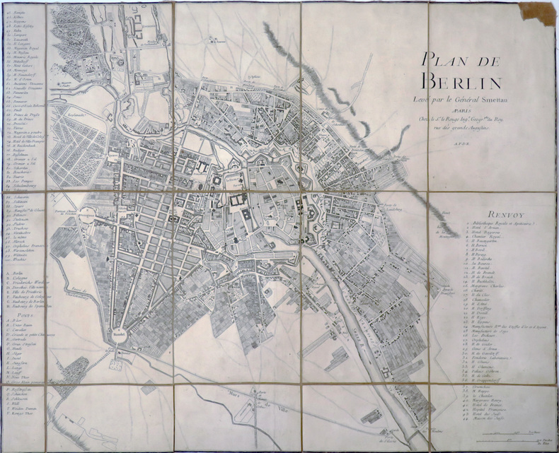
SCHMETTAU (Samuel, Graf von).
[BERLIN] Plan de Berlin levé par le Général Smettau.
Paris, Sr. Le Rouge, [1758]. En 15 sections montées sur toile et pliées, formant un plan de 506 x 611 mm.
书商的参考编号 : LBW-4058
|
|
|
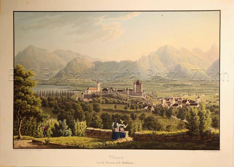
Schmid, David Alois (1791-1861)
Thoun vers Niesen et le Stockhorn.
(Zürich, Keller & Füssli), um 1830. Altkolorierte Aquatinta von Rudolf Bodmer (1805-1841). Bildgrösse: 16 x 24,1 cm. Blattgrösse: 19,4 x 27 cm. + Wichtig: Für unsere Kunden in der EU erfolgt der Versand alle 14 Tage verzollt ab Deutschland / Postbank-Konto in Deutschland vorhanden +, Abb.
书商的参考编号 : 627DG

|
|
|
Schmid, David Alois (1791-1861):
Thoun vers Niesen et le Stockhorn.
(Zürich, Keller & Füssli), um 1830. Altkolorierte Aquatinta von Rudolf Bodmer (1805-1841). Bildgrösse: 16 x 24,1 cm. Blattgrösse: 19,4 x 27 cm.
书商的参考编号 : 627DG
|
|
|
Schmid, Franz (1796-1851)
Aussicht von Zürich über den See nach den Gebirgen der kleinen Kantone. ? Vue depuis Zurich vers le lac et les montagnes de petits Cantons.
(Zürich, Keller, 1829). Aquatinta auf Papier. Bildgrösse: 10,5 x 38,7 cm. Blattgrösse: 13 x 40,5 cm. + Wichtig: Für unsere Kunden in der EU erfolgt der Versand alle 14 Tage verzollt ab Deutschland / Postbank-Konto in Deutschland vorhanden +, bild
书商的参考编号 : 597DG

|
|
|
Schmidt, Erich F.
TEPE HISSAR EXCAVATIONS 1931. The Museum Journal. Volume XXIII, Number 4, 1933.
pp. 323 - 487. Illustrated with numerous folding plates, maps and photographs. Quarto. Original printed wraps, chipped. Lacks spine. Front wrap detached. HOLY LAND BOX 1
|
|
|
Schmidt, L[udwig].
Topographische Karte der Gegenden von Wien. Astronomisch trigonometrisch aufgenommen von L. Schmidt. Wien, Johann Schönberg, [um 1850].
Gest. Karte in 16 Segmenten, auf Leinen aufgezogen und zeitgenössisch ankoloriert. 715:595 mm. Maßstab ca. 1:94 000. Nachstich der erstmals 1807 bei Cappi erschienenen Karte, die "ein Gebiet zwischen Altenmarkt a. d. Triesting (Westen) und Bruck a. d. Leitha (Osten) bzw. zwischen Schloß Schönborn (Norden) und Leobersdorf (Süden) dar[stellte]" (Dörflinger II, 502). "Die Brauchbarkeit der Karte wird dokumentiert durch Ausgaben noch Jahrzehnte später, auf denen dann auch bereits die ersten Eisenbahnlinien (Nordbahn, Südbahn) eingetragen sind" (ebd., 503). Die ÖNB hält einen anderen undatierten Nachstich, der den Titelzusatz "seiner Kays: Majestät Alexander I. [...] gewidmet" trägt und im Katalog "um 1813" angesetzt wird. - Leinen zwischen zwei Segmenten eingerissen, sonst sauber und wohlerhalten. Dörflinger II, 503, Fußn. 56. Vgl. Tooley II, 124.

|
|
|
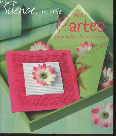
Schneegans Marie-Pierre
"Silence, je crée... mes cartes pour toutes les occasions (Collection ""Silence, je crée..."")"
France Loisirs/Tana. 2005. In-8. Broché. Bon état, Coins frottés, Dos satisfaisant, Intérieur acceptable. 91 pages. Couverture contrepliée. Quelques rousseurs. Nombreuses illustrations et photos en couleurs, in et hors texte.. . . . Classification Dewey : 741.68-Illustrations des cartes postales
书商的参考编号 : RO30354038
|
|
|
Schofield, Daniel (editor)
The Kingdom of Saudi Arabia (fully revised edition)
Inscription on ffep. No other marks. A lovely clean crisp very tight copy with bright boards and gilt lettering and with no bumping to corners. Dust jacket not price clipped or torn or creased. The delightful slip-case with gilt English and Arabic writing and design on a dark green vellum-type background is in excellent condition. 256pp.

|
|
|
SCHOTT Franciscus; PERION Joachim:
Itinerarii Italiae, Germaniaeque libri IIII. Ad hac iter Galliae et Hispaniae. [relié à la suite] Ioachimi Perionii benedictini Cormoeriaceni De rebus gestis, vitisque apostolorum liber.
Coloniae Agrippinae [et] Coloniae, sumptibus Bernardi Gualtheri [et] Theodoricum Baumium, 1620 - 1569. Trois tomes en un volume in-12 de [30]-456 (chiffrée 454)-[10] ; 161-[3] ; 216 pages, plein vélin à recouvrement, titres inscrit à la plume au dos.
书商的参考编号 : 16533

|
|
|
 ?????????
 ?????PDF???
 RSS feed


