|
SPHYROERAS
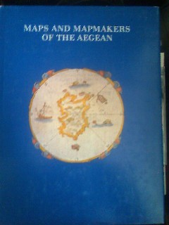
Maps and mapmakers of the aegean
apla6. In-4, relié toilé marron d'édition, jaquette illustrée (legerement frottée sur les coins), livre en tres bon état. 267 pages. Illustré. Éditeur : Athens, Olkos LTD texte en anglais. Date d'édition : 1985
书商的参考编号 : CCC00460
|
|
|
Sphyroeras Vasilis & Avramea Anna & Asdrahas Spyros
Maps and Mapmakers of the Aegean
Athens: Olkos Publishers 1985 New - will be sent to you direct from the publisher in GreeceTranslated by G. Cox J. Solman. The charting of the Aegean Sea or the Greek Archipelago from the 15th up to the 19th century. 236p. Map Index; General Index. 166 color and black & white maps. 1st Greek Edition. Hard Cover. Fine/Fine. Olkos Publishers hardcover
书商的参考编号 : 28012
|
|
|
Sphyroeras, Vasilis & Avramea , Anna & Asdrahas, Spyros
Maps and Mapmakers of the Aegean
Translated by G. Cox, J. Solman. The charting of the Aegean Sea, or the Greek Archipelago, from the 15th up to the 19th century. 236p. Map Index; General Index. 166 color and black & white maps Book
|
|
|
Sphyroeras, Vasilis & Avramea , Anna & Asdrahas, Spyros
Maps and Mapmakers of the Aegean
The charting of the Aegean Sea, or the Greek Archipelago, from the 15th up to the 19th century. English translation by G. Cox & J. Solman. 236p. Map Index; General Index. 166 color and black & white maps Book
|
|
|
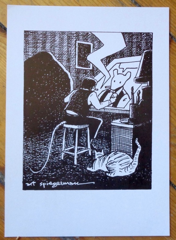
Spiegelman Art:
Self portrait.
Basel, Comix Shop, 1997. Carton d'invitation (auf Deutsch, au format 15 x 21 cm.) au vernissage de l'exposition "Art Spegelman - Prints".
书商的参考编号 : 9049
|
|
|
Spiegl Fritz
FOUR CENTURIES OF LIVERPOOL The Growth of a City A Collection of Maps and Views
Liverpool: Scouse Press 1970. This is the revised "Liverpool Packet No. 2" with the additional maps. Numerous maps and plans - all present and correct- checked against contents list some colour and many folding printed on different colour papers historical notes also present. In original plastic wallet which is a little worn and marked. The title page is faded and has a number written to the reverse otherwise no other marks or inscriptions to maps or notes. Some maps with small creases to corners and some a little browned along edges. A good to very set. 2nd Printing. Paperback. Very Good. 4to. Scouse Press Paperback
书商的参考编号 : 007181
|
|
|
SPK.
[PROPAGANDE SECONDE GUERRE MONDIALE] Confiance... ses amputations se poursuivent méthodiquement.
[entre 1941 et 1942]. Affiche en couleurs de 114,5 x 75 cm.
书商的参考编号 : LBW-8634

|
|
|
SPON M:
Histoire de Genève. Rectifiée & augmentée par d’amples Notes. Avec les actes et autres pièces servant de Preuves à cette Histoire.
A Genève, Chez Fabri & Barrillot, 1730. 2 volumes in-4 de XV-556-[10], 518 pages + 2 grandes planches dépliantes et 1 carte. Plein veau marron moucheté, dos à nerfs ornés de fleurons et roulettes dorés, pièces de titre et tomaison de maroquin havane, tranches rouge.
书商的参考编号 : 2358
|
|
|
SPON [Jacob]; [GAUTIER Antoine (notes)]:
Histoire de Genève. Rectifiée & augmentée par d’amples Notes. Avec les actes et autres pièces servant de Preuves à cette Histoire.
A Genève, Chez Fabri & Barrillot, 1730. 2 volumes in-4 de [4]-XV-556-[2] et [8]-518 pages, plein veau brun, dos à 5 nerfs ornés de fleurons, roulettes. Exemplaire non rogné, reliure pastiche moderne.
书商的参考编号 : 21028

|
|
|
Spofford, Jeremiah.
A GAZETTEER OF MASSACHUSETTS: Containing a General View of the State, with an Historical Sketch of the Principal Events From Its Settlement to the Present Time, and Notices of the Several Towns Alphabetically Arranged. With a Map of the State.
348 p. Folding colored map of Massachusetts. The map could use some minor repairs at folds, etc. 12mo. Contemporary full leather binding. American Imprints 35374; Howes S-839; Sabin 89563. Atlas Case. QUITE SCARCE. **PRICE JUST REDUCED!
|
|
|
Sporrong Ulf, Wennstrom Hans-Fedrik
Maps and Mapping. National Atlas of Sweden
34 cm, rilegatura editoriale, titolo in oro al piatto e al dorso, sovracopertina illustrata; p. 205, numerose illustrazioni e carte geografiche a colori, testo in inglese

|
|
|
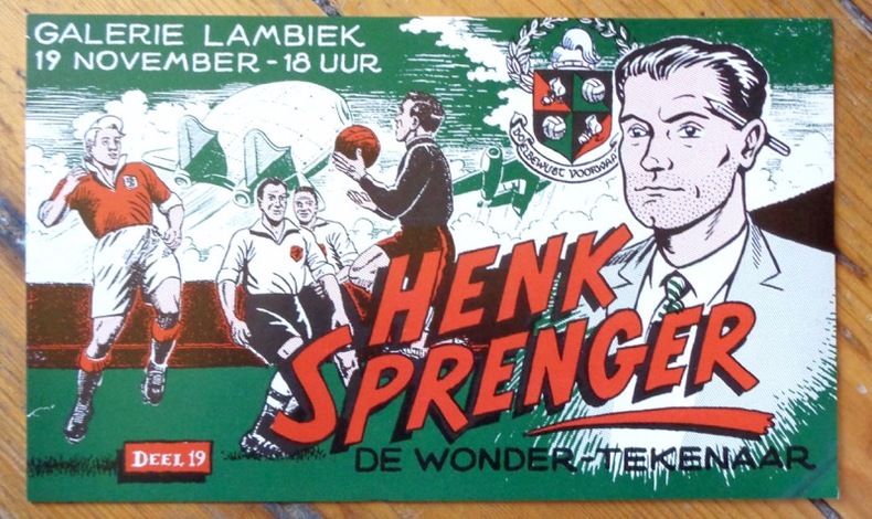
Sprenger Henk:
De wonder-tekenaar.
Galerie Lambiek, sans date. Carton d'invitation à une exposition consacrée au "dessinateur miracle". Format 21,5 x 13 cm., petit pli au coin inférieur.
书商的参考编号 : 9051
|
|
|
Spring Ira; Manning Harvey Photos By Spring Bob And Ira Maps By Sherman Helen
101 Hikes in the North Cascades
Seattle Washington U.S.A. : Mountaineers Books 1979. 0/0. 1979. F. Soft cover. 9780916890827 0/0 null 0916890821 null null 0916890821 Library of Congress: 79-10865 This trade size paperback is a nice tight clean binding. Some cover creases and wear. There is an owner name and other marks inside. 240 pages. . Seattle, Washington, U.S.A. : Mountaineers Books, 1979 paperback
书商的参考编号 : 10111 ???????? : 0916890821 9780916890827

|
|
|
Square One Maps
San Juan Islands WA State
2013-08-01. New. Ships with Tracking Number! INTERNATIONAL WORLDWIDE Shipping available. May be re-issue. Buy with confidence excellent customer service! unknown
书商的参考编号 : 1883735300n ???????? : 1883735300 9781883735302

|
|
|
Square One Maps
San Juan Islands WA State
2013-08-01. Good. Ships with Tracking Number! INTERNATIONAL WORLDWIDE Shipping available. May not contain Access Codes or Supplements. May be re-issue. May be ex-library. Shipping & Handling by region. Buy with confidence excellent customer service! unknown
书商的参考编号 : 1883735300 ???????? : 1883735300 9781883735302

|
|
|
ST BRIEUC
Cartes d'Etat major type 1889 : St Brieuc - St Brieuc S-E
2 cartes 34x53 cm.
|
|
|
St Pierre Brian; Jones Deborah Photographer; Sturman Sally Mara Maps & illus
Perfect Glass of Wine: Choosing Serving and Enjoying Great Wines A
San Francisco: Chronicle Books LLC. Fine in Fine dust jacket 1996. First Edition. Hardcover. Marfree acidfree 1stEd; not written-in underlined reprint/club or ex-library. Thick coated paperboards; heavy-weight unclipped color photographic jacket lite rubbing. Mail SAMEDAY! ; 0.89 x 9.64 x 9.25; 120 pages; Publisher Review: Many people are intimidated by wine. In fact there's nothing more complicated about it than trying the different kinds and seeing what you like. The ultimate test for any wine is purely subjective: Do you like the taste In this practical and elegant guide to wine you'll find the key to answering that question with confidence. A Perfect Glass of Wine reveals how truly easy it is to relax and savor the fruit of the vine. All the wines in the world come from just a few varieties of grape and the grape determines the wine's flavor. Once these categories of flavor are understood all the rest flows as easily as wine into the glass - how to match wine with food how to store and serve it which are the right occasions for a certain type of wine and even how much of a fuss to make over a bottle and how much to . Chronicle Books LLC hardcover
书商的参考编号 : 1678 ???????? : 0811812952 9780811812955

|
|
|
ST. PETERSBURG - COLLINS, WILLIAM.
St. Petersburg.
London, Glasgow & Edinburgh ca. 1870. Coloured lithograph showing a bird's eye view of the city. 22 x 28 cm. Framed and matted.
书商的参考编号 : 38865
|
|
|
St. Louis Area Maps Inc
Wunnenberg's St. Charles County street guide
St. Louis Area Maps. Used - Good. Shows some signs of wear and may have some markings on the inside. St. Louis Area Maps unknown
书商的参考编号 : GRP109108422 ???????? : 187917202x 9781879172029
|
|
|
St. Louis Area Maps Inc
Wunnenberg's 1996 Jefferson County street guide
St. Louis Area Maps Inc. Used - Very Good. Great condition for a used book! Minimal wear. St. Louis Area Maps Inc unknown
书商的参考编号 : GRP109150189 ???????? : 1879172038 9781879172036
|
|
|
ST. PETERSBURG - COLLINS, WILLIAM.
St. Petersburg.
London, Glasgow & Edinburgh ca. 1870. Coloured lithograph showing a bird's eye view of the city. 22 x 28 cm. Framed and matted.
|
|
|
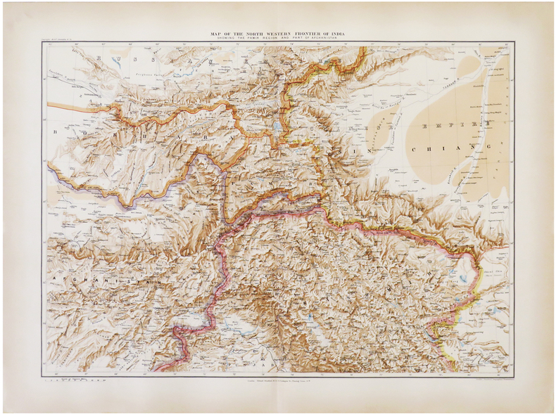
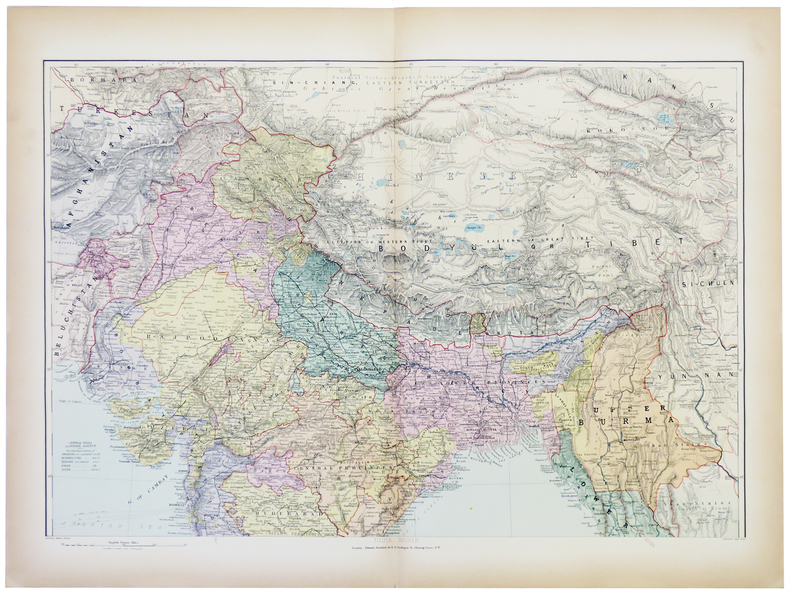
STANFORD (Edward).
[AFGHANISTAN & PAKISTAN] Map of the north western frontier of India showing the Pamir region and part of Afghanistan.
London, Edward Stanford, 1896. 470 x 640 mm.
书商的参考编号 : LBW-6821
|
|
|
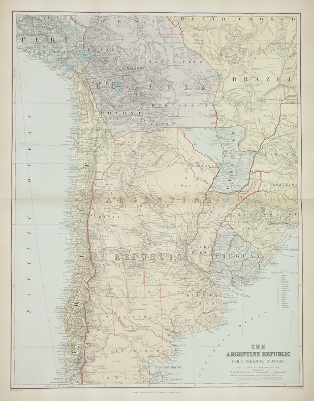
STANFORD (Edward).
[ARGENTINE] The Argentine Republic. Chile, Paraguay, Uruguay.
London, Edward Stanford, [1896]. 660 x 500 mm.
书商的参考编号 : LBW-2879
|
|
|
STANFORD (Edward).
[BIRMANIE] Burma and adjacent countries.
London, Edward Stanford, [1896]. 720 x 520 mm.
书商的参考编号 : LBW-2871

|
|
|
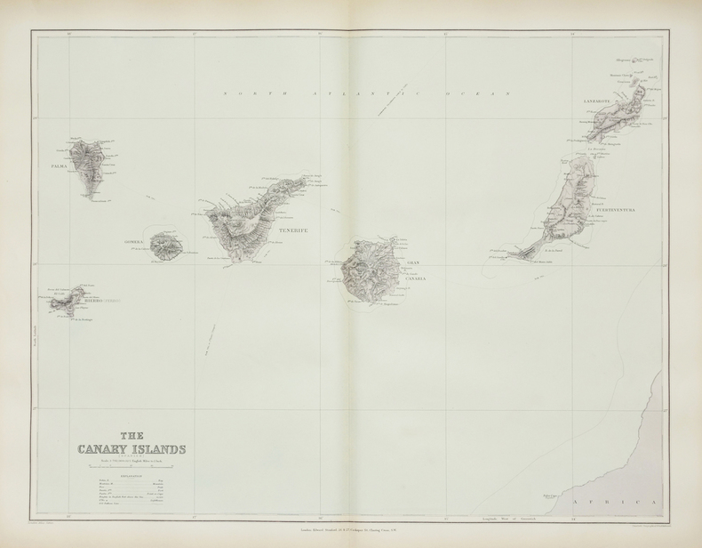
STANFORD (Edward).
[CANARIES] The Canary Islands (Spanish).
London, Edward Stanford, [1896]. 480 x 622 mm.
书商的参考编号 : LBW-2867
|
|
|
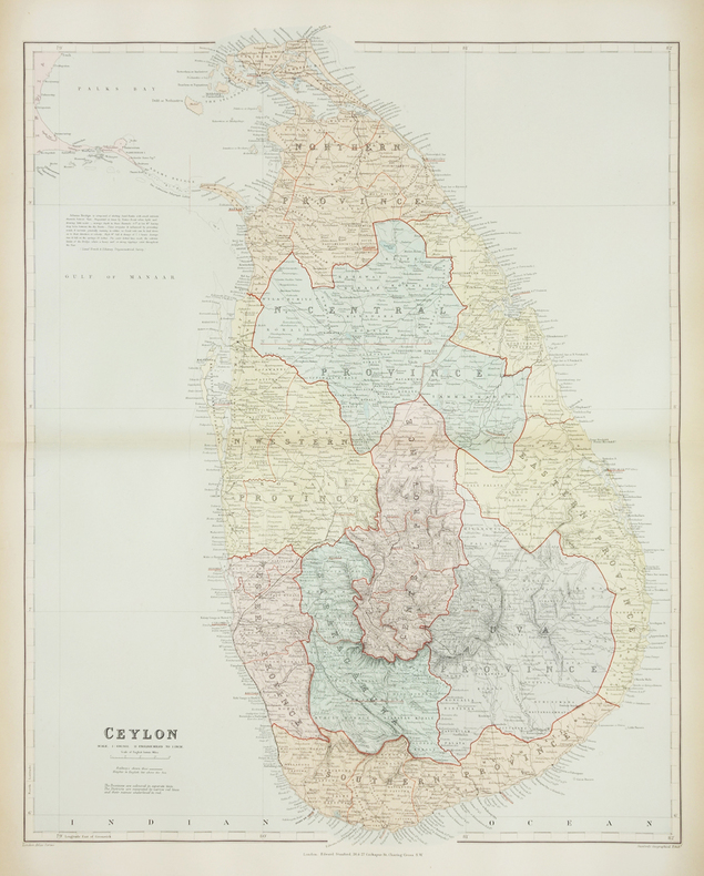
STANFORD (Edward).
[CEYLAN/SRI LANKA] Ceylon.
London, Edward Stanford, [1896]. 640 x 503 mm.
书商的参考编号 : LBW-2872
|
|
|
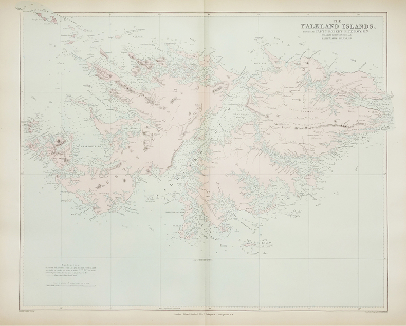
STANFORD (Edward).
[FALKLAND/MALOUINES] The Falkland Islands.
London, Edward Stanford, [1896]. 520 x 630 mm.
书商的参考编号 : LBW-2880
|
|
|
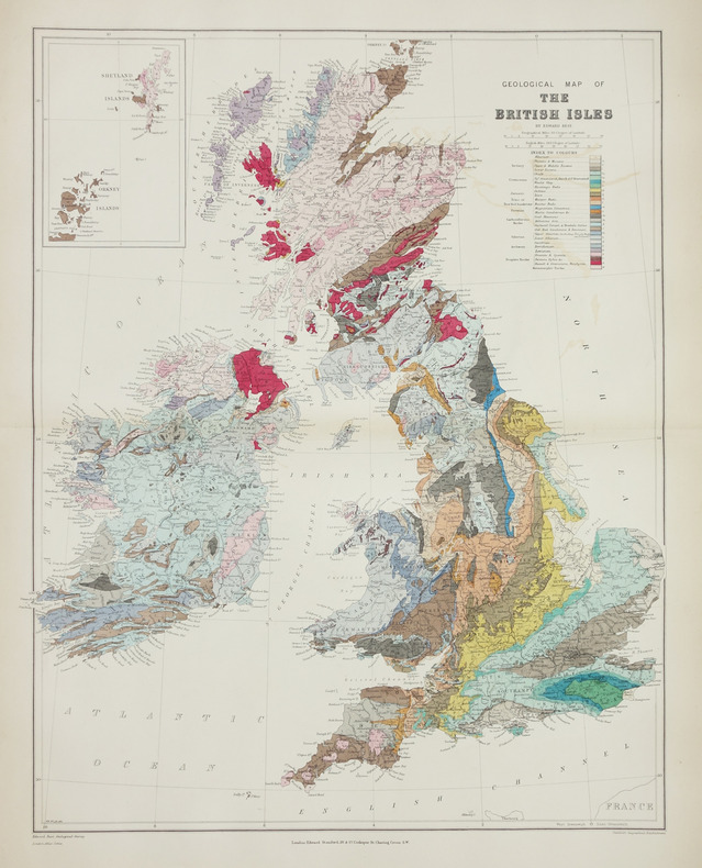
STANFORD (Edward).
[GÉOLOGIE] Geological map of the British Isles.
London, Edward Stanford, [1896]. 610 x 480 mm.
书商的参考编号 : LBW-2865
|
|
|
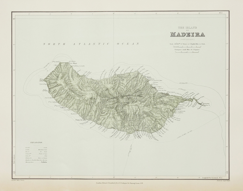
STANFORD (Edward).
[MADERE] The Island of Madeira (Portuguese).
London, Edward Stanford, [1896]. 322 x 406 mm.
书商的参考编号 : LBW-2868
|
|
|
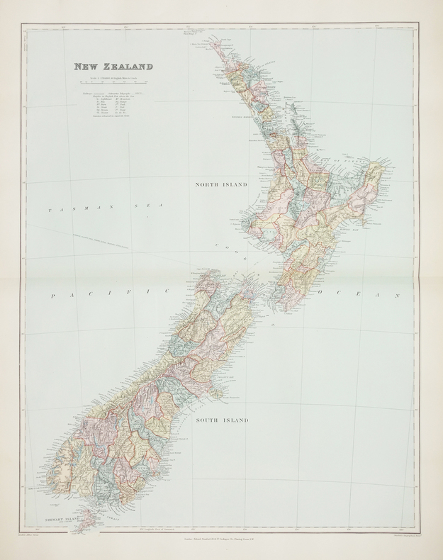
STANFORD (Edward).
[NOUVELLE-ZÉLANDE] New Zealand.
London, Edward Stanford, [1896]. 606 x 470 mm.
书商的参考编号 : LBW-2760
|
|
|
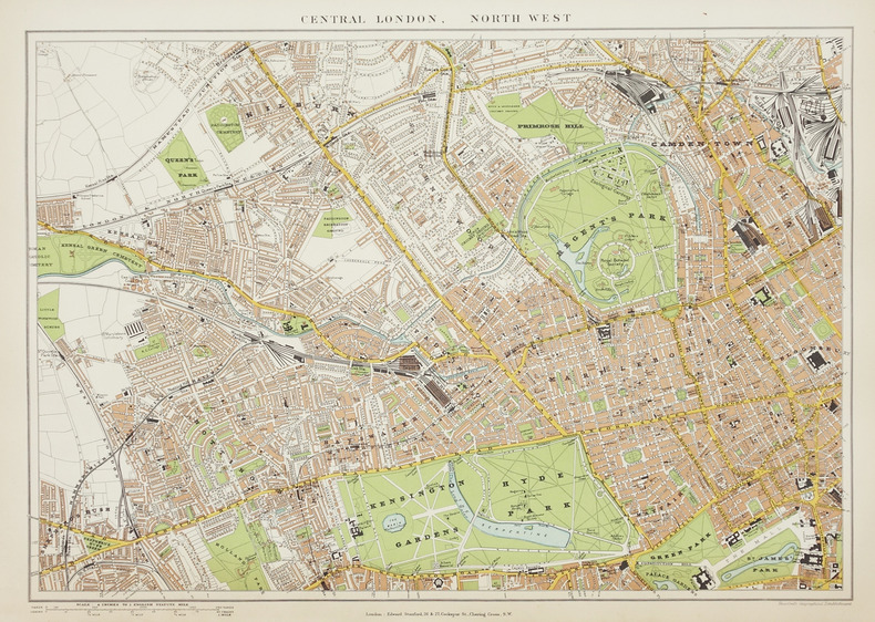
STANFORD (Edward).
[Plan de Londres].
London, Edward Stanford, [1896]. En quatre feuilles séparées, chacune environ 350 x 505 mm.
书商的参考编号 : LBW-2866
|
|
|
STANFORD (Edward).
[TASMANIE & FIDJI] Tasmania - Fiji archipelago.
London, Edward Stanford, [1896]. 539 x 308 mm.
书商的参考编号 : LBW-2744

|
|
|
STANFORD (Edward).
[ÎLES IONIENNES & MALTE] Map of the Ionian Islands and Malta.
London, Edward Stanford, [1896]. 630 x 540 mm.
书商的参考编号 : LBW-2869

|
|
|
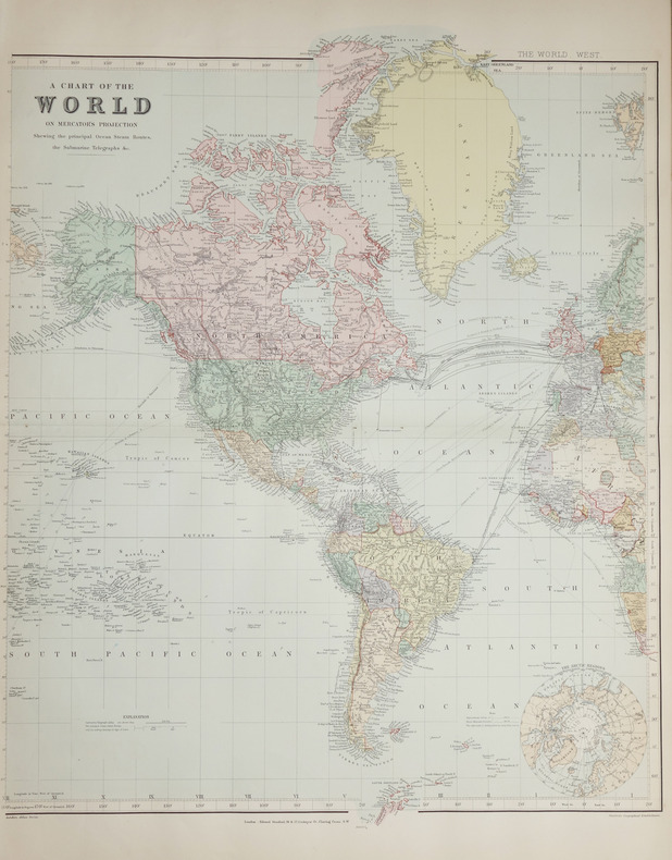
STANFORD (Edward).
A Chart of the World on Mercator's projection.
London, Edward Stanford, [1896]. En deux feuilles non jointes pouvant former une carte de 0,66 x 1,07 m.
书商的参考编号 : LBW-2686
|
|
|
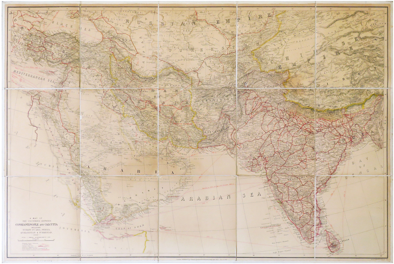
STANFORD (Edward).
A Map of the countries between Constantinople and Calcutta including Turkey in Asia, Persia, Afghanistan & Turkestan.
London, Edward Stanford, 1912. En 15 sections montées sur toile et pliées, formant une carte de 0,68 x 1,02 m.
书商的参考编号 : LBW-6838
|
|
|
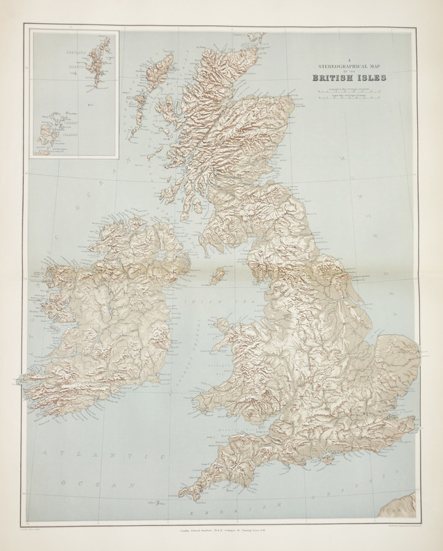
STANFORD (Edward).
A stereographical map of the British Isles.
London, Edward Stanford, [1896]. 605 x 478 mm.
书商的参考编号 : LBW-2864
|
|
|
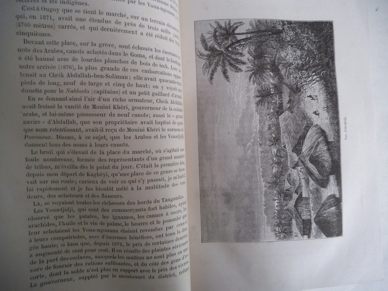
STANLEY Henri M.
A travers le Continent mystérieux
découverte des sources méridionales du Nil, circumnavigation du lac Victoria et du lac Tanganika, descente du fleuve Livingstone ou Congo jusqu’à l’atlantique.Durée de l’expédition 990 jours,distance parcourue 11571 km.Traduit de l’anglais avec l’autorisation de l’auteur.Deux tomes en deux volumes in 8 demi-chagrin rouge d’époque,titre,roulette,filets,dorés.Tome1:faux-titre,frontispice portait de STANLEY,titre,6 pages,IV,Une carte en couleurs Stanley 1874-1877.490 pages,nombreuses illustrations gravées sur bois dans et hors-texte.Six cartes en couleurs dont une très grande dépliante(78x87cm) en fin de volume.Tome 2:Faux-titre,frontispice,titre,544 pages,nombreuses illustrations dans et hors-texte. 3 cartes dont une très grande dépliante, en couleurs(70x87 cm),en fin de volume.Hachette & Cie 1879 édition originale de la traduction française. Quelques petites rousseurs en début et fin de volume,sinon très bon état.
书商的参考编号 : 5674
|
|
|
STANLEY Henri Morton:
A travers le continent mystérieux. Découverte des sources méridionales du Nil. Circumnavigation du lac Victoria et du lac Tanganika. Descente du fleuve Livingstone ou Congo jusqu'à l'Atlantique.
Paris, Librairie Hachette et Cie, 1879. 2 volumes in-4 de [12]-496-[2] et [6]-544 pages, demi-chagrin brun, dos à nerfs.
书商的参考编号 : 20578

|
|
|
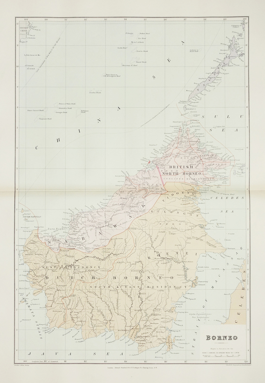
STANFORD (Edward).
Borneo.
London, Edward Stanford, [1896]. 610 x 406 mm.
书商的参考编号 : LBW-2874
|
|
|
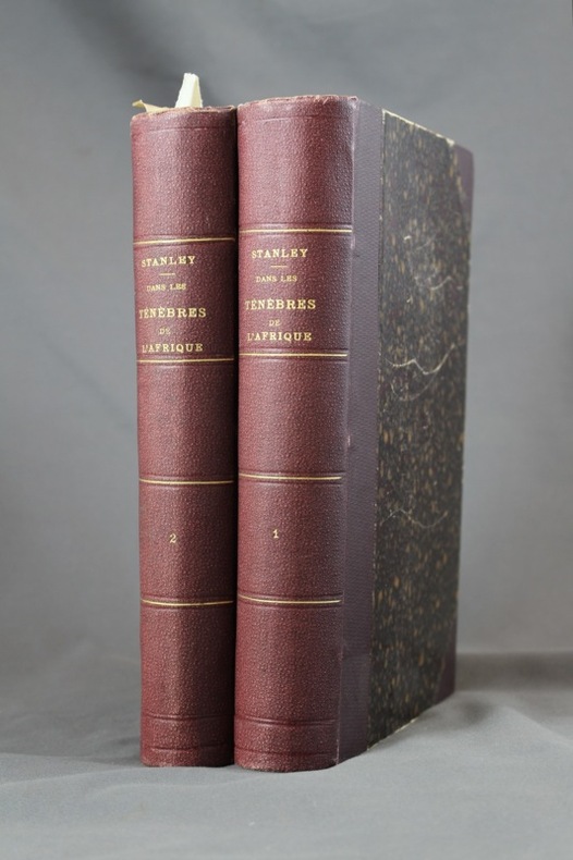
STANLEY Henry Morton:
Dans les ténèbres de l'Afrique. Recherche, délivrance et retraite d'Emin Pacha. Tomes I & II.
Paris, Hachette, 1890. 2 volumes grand in-8 de [8]-518 et [8]-482-[4] pages, demi-percaline aubergine à coins, dos ornés de filets, titre et tomaison dorés. Inscription de possesseur sur garde des 2 vol., plats griffés avec quelques salissures, rousseurs; la carte dépliante à la fin du premier volume est déchirée sur une bonne partie du pli central, proprement et sans perte.
书商的参考编号 : 6971
|
|
|
Stati Sardi in terraferma
Gran Carta degli Stati Sardi in terraferma.N° 63 Sampeyre.
1870 portfolio toile noire éditeur. carte toilée 55 x 74 cm. Torino G. B. Maggi 1870
书商的参考编号 : 16226
|
|
|
Stati Sardi in terraferma
Gran Carta degli Stati Sardi in terraferma.N° 70 Entraunes
1870 portfolio toile noire éditeur. carte toilée 53 x 37 cm. Torino G. B. Maggi 1870
书商的参考编号 : 16227
|
|
|
Stati Sardi in terraferma
Gran Carta degli Stati Sardi in terraferma.N° 79 St Martin d'Entraunes
1870 portfolio toile noire éditeur. carte toilée 53 x 36 cm. Torino G. B. Maggi 1870
书商的参考编号 : 16228
|
|
|
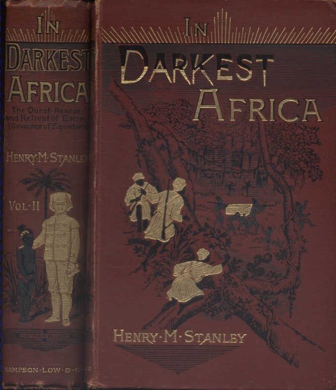
STANLEY Henry M. 150 woodcut illustrations and maps. Decorative cloth bound by Leighton Son & Hodge.
In darkest Africa, or the quest, rescue, and retreat of Emin Governor of Equatoria. Two volumes in good condition.
Couverture rigide. Reliures toile rouge illustrées. 530 + 472 pages. Quelques rousseurs.
书商的参考编号 : 128712
|
|
|
STANFORD (Edward).
India and the adjacent parts of Beluchistan, Afghanistan, Turkestan, the Chinese empire, and Siam.
London, Edward Stanford, [1896]. En deux feuilles non jointes pouvant former une carte de 801 x 676 mm.
书商的参考编号 : LBW-5383
|
|
|
STAYMAN Samuel M.
Le système Stayman de bridge-contrat.
Paris, Grasset, 1956 14 x 21, 269 pp., broché, bon état
书商的参考编号 : 3316
|
|
|
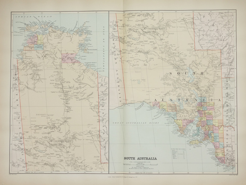
STANFORD (Edward).
South Australia.
London, Edward Stanford, [1896]. 482 x 659 mm.
书商的参考编号 : LBW-2687
|
|
|
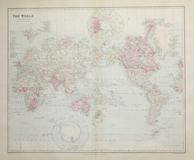
STANFORD (Edward).
The World on Mercator's projection showing the British possessions.
London, Edward Stanford, [1896]. 496 x 603 mm.
书商的参考编号 : LBW-2662
|
|
|
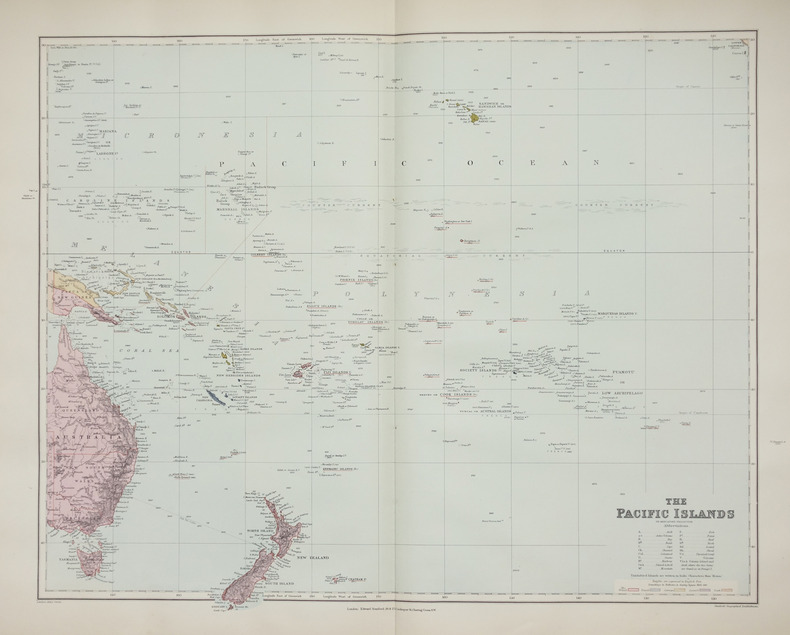
STANFORD (Edward).
The Pacific islands on Mercator's projection.
London, Edward Stanford, [1896]. 480 x 603 mm.
书商的参考编号 : LBW-2658
|
|
|
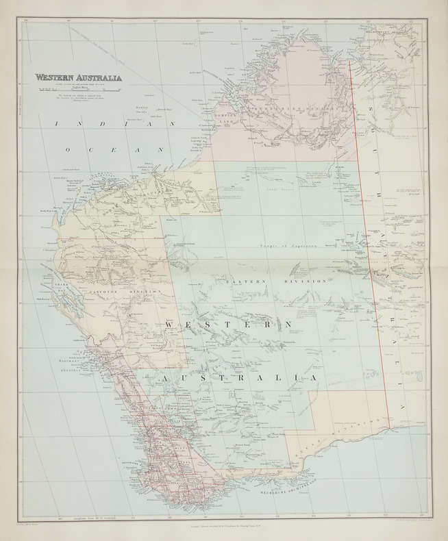
STANFORD (Edward);
Western Australia.
London, Edward Stanford, [1896]. 508 x 628 mm.
书商的参考编号 : LBW-2708
|
|
 ?????????
 ?????PDF???
 RSS feed


