|
|
|
[ROCHAMBEAU, Jean-Baptiste Donatien, de Vimeur comte de].
I. « Plan des ville, citadelle, forts et port de Calais »; II. Cassini. Carte particulière des environs de Lille, Tournay, Valenciennes, Bouchain, Douay, Arras, Béthune. 1745.
[I. France, circa 1780]. II. Bruxelles, chez George Fricx, rue de la Madeleine, imprimeur. 1745. 1780 I: 1 feuille de 1 102 mm par 511 mm, tracée à l'encre et aquarellée ; II: 1 feuille de 420 mm par 456 mm, imprimée en noir. Les deux sont contrecollées sur toile. Cartonnage-étuis d'époque à rabats.
Ссылка продавца : 4944

|
|
|
[RONDEAUX DE SETRY] LOYER.
Plan de la Ville de Rouen renfermée dans sa 1ère enceinte comme elle était sous Raoul et nos premiers ducs qui l'augmentèrent beaucoup du coté du midi et ressérèrent le lit de la rivière de près d'un tiers.
s.d. (XIXème). Plan manuscrit aquarellé (41 x 26 cm), légende des lieux en marge.
Ссылка продавца : 13279

|
|
|
[RONDEAUX DE SETRY] RENAUD (C. R.).
Rouen au X & au XIe Siècle.
1882. Plan manuscrit aquarellé (55 x 35 cm), nombreuses annotations manuscrites reprises sur le plan original.
Ссылка продавца : 9933

|
|
|
[RUCHAT Abraham; THURNEYSEN Emanuel; STANYAN Abraham; ALTMANN Johann Georg:
Etat et délices de la Suisse ou Description historique et géographique des treize cantons suisses et de leurs alliés. Nouvelle édition, corrigée & considérablement augmentée par plusieurs auteurs célèbres, & enrichie de figures en taille douce & de cartes géographiques.
A Neuchâtel, chez Samuel Fauche, 1778. 2 volumes in-4 de [4]-454-[2] et [4]-388 pages, demi-basane blonde, dos lisses ornés de roulettes, filets, fleurons, titre et tomaison dorés, étiquettes de titre et tomaison rouges, tranches jaunes. Dos un peu frottés, mors du premier volume fendu en queue sur 5 cm., premières charnières faibles, un cahier très légèrement déboîté.
Ссылка продавца : 10246
|
|
|
[sans auteur] - RIQUETTI [ou RIQUETI] (Victor, Comte de MIRABEAU).
Atlas de la monarchie prussienne [sous Frédéric le Grand].
A Londres, s.é. [Lejay], 1788. Un fort vol. au format in-folio (433 x 277 mm) de 3 ff. n.fol., [10] cartes gravées sur double-page,, 93 planches gravées + tableaux et 1 f. bl. Ne subsiste plus de la reliure que le carton des plats.
Ссылка продавца : 26048

|
|
|
[sans auteur].
Petit atlas national des 86 départements de la France et de ses colonies.
(Paris), Blaisot, 1835. Un fort vol. au format pt in-4 (263 x 182 mm) de 1 titre-frontispice n.fol. et [99] planches gravées sur double-page. Reliure de l'époque d edemi-basane glacée sapin, dos lisse orné de doubles filets dorés, larges fleurons romantiques dorés, titre doré.
Ссылка продавца : 26317

|
|
|
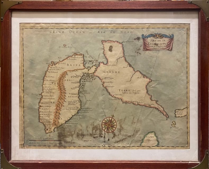
[SANSON D'ABBEVILLE (Nicolas)].
Isle de la Guadeloupe.. Scituée à 16 degrez de Lat .Septentrionale. A Paris chez Pierre Mariette, rue S.Iacques à L'Espérance. Avec Privilège du Roy
Paris, MARIETTE Pierre, (vers 1662) à vue : 32 x 43,5 cm - cadre : 43 x 52.5 cm , Cadre du XXe siècle. Déchirures dont une au coin inférieur gauche et une au niveau inférieur de la pliure centrale. Taches.
Ссылка продавца : 230537
|
|
|
[Saudi Arabia and Yemen].
Collection of USAF Aeronautical Charts. Washington, DC, Army Map Service, 1942 and 1944.
8 charts. 560 x 735 mm, with key printed on the back. Scale 1:1,000,000. Substantial set of first edition U.S. pilot charts from the Second World War. Includes 2 maps of the Arabian Peninsula (668 and 669), depicting the border region of Saudi Arabia, Yemen and the Aden Protectorate and covering the area between the 42nd and 54th meridian east, and between the 16th and 20th parallel north. Also shows the Frasan Islands as well as large parts of the Rub' al Kahli desert with sections marked "unexplored", the city of Salala constituting the easternmost point. - Further, two maps of Iran (429 and 443) between the 53rd and 60th meridian east, and the 28th and 36th parallel north, identifying Kerman, Yazd and Birjand. - The remaining maps cover western Afghanistan (439), labelling Herat and Farah, central India (559), with cities such as Jabalpur, Bhopal and Achalpur, and the Indian Ocean showing the Chagos archipelago (1037) and Comoro Island (1052). - Chart no. 1037 dampstained with loss to the centre, chart no. 669 lacks approx. 5.5 cm, clipped away at upper margin. Remaining maps with occasional small tears, but overall in good condition.
|
|
|
[Saudi Arabia].
Abl Ghamghimah. Series K 502, Sheet NE 39-4, Edition 1-AMS. Washington, D.C., Army Map Service, 1965.
Folding map. Ca. 755 x 570 mm. Scale 1:250,000. Military geological map of 'Abl Ghamghimah in the Eastern Province of Saudi Arabia. Prepared by the U.S. Army after aerial photography in December 1954 and January/February 1955. Reprinted for the UK Ministry of Defence with their stamp: "Limited distribution. U.K. officials are not to release the map outside government service". The chart details the average relative heights of sand dunes as well as sabkhas and water wells. - Occasional light browning.
|
|
|
[Saudi Arabia].
Al Jauf H-37. Potsdam, Ministerium für nationale Verteidigung, 1965/1966.
645 x 590 mm. Scale 1:1,000,000. Topographical map covering the northern part of Saudi Arabia around the town of Jawf (Jauf) and Wadi Sirhan. It shows international boundary, populated places, roads and tracks, railways, wireless telegraph stations, forts, wadis, wells, vegetation and terrain features. Shows also parts of Transjordan and Iraq. Relief shown by hachures, spot heights and gradient tints. - A few brown spots near upper left corner. Very well preserved.
|
|
|
[Scherz, C. F.]
Die Nordsee-Insel Borkum. Nebst ärztlichen Ratschlägen und Winken, betreffend die Seereise, den Aufenthalt auf der Insel und den Gebrauch des Seebades. 10. vermehrte u. verbesserte Aufl.
Emden u. Borkum, W. Haynel, [ 1901]. VIII, 286 S., 22 AnzeigenS. Mit 119 Abb. u. Illustr. im Text u. 1 farbig lithograph., mehrfach gefalt. Plan. 19,5 cm. Farbig illustr. OLn.
Ссылка продавца : 98304

|
|
|
[Scherz, C. F.]
Die Nordsee-Insel Borkum. Nebst ärztlichen Ratschlägen und Winken, betreffend die Seereise, den Aufenthalt auf der Insel und den Gebrauch des Seebades. 10. vermehrte u. verbesserte Aufl.
Emden u. Borkum, W. Haynel, [ 1901]. VIII, 286 S., 22 AnzeigenS. Mit 119 Abb. u. Illustr. im Text u. 1 farbig lithograph., mehrfach gefalt. Plan. 19,5 cm. Farbig illustr. OLn.
Ссылка продавца : 98954
|
|
|
[SEINE-ET-MARNE]
Carte de la Forêt de Fontainebleau. avec un plan de la ville à l'usage des promeneurs, des cyclistes et des automobilistes
Paris, A. Taride, s.d. in-8, broché. Petite mouillure à la couv.
Ссылка продавца : 188829
|
|
|
[SERVICE HYDROGRAPHIQUE DE LA MARINE] BOUQUET DE LA GRYE - INGENIEUR HYDROGRAPHE
CÔTE OCCIDENTALE DE FRANCE : COURS DE LA LOIRE DEPUIS NANTES JUSQU'A SON EMBOUCHURE - 1891 -
Nantes SERVICE HYDROGRAPHIQUE DE LA MARINE 1891 in-8 une carte dépliante entoilée in-octavo, format plié : (24 x 16 cm), plats cartonnés recouvert de percaline bleu-marine, N° 4321 frappé "or" au centre du dos (N° de référence de la carte en bas à droite de la gravure ), divisée en 21 panneaux, format déplié : 105 centimètres de large par 68,5 centimètres de haut, Carte gravée par Emile DELANNE, 1891 Paris SERVICE HYDROGRAPHIQUE DE LA MARINE Editeur ,
Ссылка продавца : 22306
|
|
|
[Shell]
CARTE REGIONALE SHELL N° 1 "NORD - BELGIQUE"
Carte géographique, format ouvert 910 x 660 mm, éditée en 1940, bon état
Ссылка продавца : LFA-126737263
|
|
|
[Siebenbürgen] - Tîrgu Mures.
Libera regiaque civitas siculica Maros Vasarhely. Targu Mures, [1822-]1827.
Kupferstich von Samuel Nagy nach Mikolai Tóth Istvan. 415:780 mm. Unter Passepartout. Prachtvolle und großformatige, als Einzelblatt erschienene Gesamtansicht der Stadt Targu Mures (dt. Neumarkt am Mieresch, ungar. Marosvásárhely) in Siebenbürgen. - Bei der in den Jahren 1822-25 entstandenen Ansicht der Stadt aus der Vogelschau handelt es sich um die bis dahin genaueste topographische Aufnahme der Stadt, die bis zum Beginn des 20. Jahrhunderts unübertroffen bleiben sollte. Vorangegangen waren dem vorliegenden Blatt lediglich zwei kleinere und recht ungenaue Veduten von 1736 bzw. 1750; die früheste bei Nebehay/Wagner genannte Ansicht der Stadt datiert überhaupt erst von 1840. Die eingedruckte Legende im unteren weißen Rand benennt die wichtigsten Gebäude und Monumente, dazwischen ein Adler das Stadtwappen haltend. - Breitrandig mit umlaufendem Plattenrand und sehr sauber. Minimale Randläsuren außerhalb des Passepartoutausschnittes fachmännisch restauriert. Von größter Seltenheit. Keresztes Gyula. Marosvásárhely látképe és házsorainak képe Mikolai Tóth István rajzai alapján, Milléniumi megemlékezés, Juventus Kiadó, Marosvásárhely, 2000, SS. 230-237.

|
|
|
[Southern Palestine].
Seetzens Entwurf einer Original Charte von Dschebal (Gebalene) und Scharah- (Seir-) Gebirge. Nach mündlichen Nachrichten [...] mit Hinzufügung der alten Namen von Fr. Kruse. [Berlin, G. Reimer, 1859].
Lithographed map, single sheet. 455 x 560 mm (image size), 516 x 645 mm (sheet size). Scarce lithographed map of southern Palestine showing the travel route of the German orientalist Ulrich Jasper Seetzen (1767-1811), designating landmarks like Petra and Saint Catherine's Monastery on the Sinai Peninsula, as well as geological features. The main map shows Seetzen's itinerary from the Be'er Sheva area to its intersection with the Egyptian caravan road from Mecca to Cairo, flanked in the east by Al-Sharah mountains and the Gebalene region. An inset depicts the continuation of the route from there to Mount Sinai, while another contains a detailed plan of the mountain. Features comments on soil fertility as well as labels of notable settlements, mountains, streams, and wall remains encountered along the route. - Prepared by A. Bräunig, the map was issued as plate 3 in the fourth volume of Seetzen's posthumous travelogue series "Reisen durch Syrien, Palästina, Phönicien, die Transjordan-Länder, Arabia Petraea und Unter-Aegypten", published from 1855 to 1859. - Very well preserved. OCLC 5061964.
|
|
|
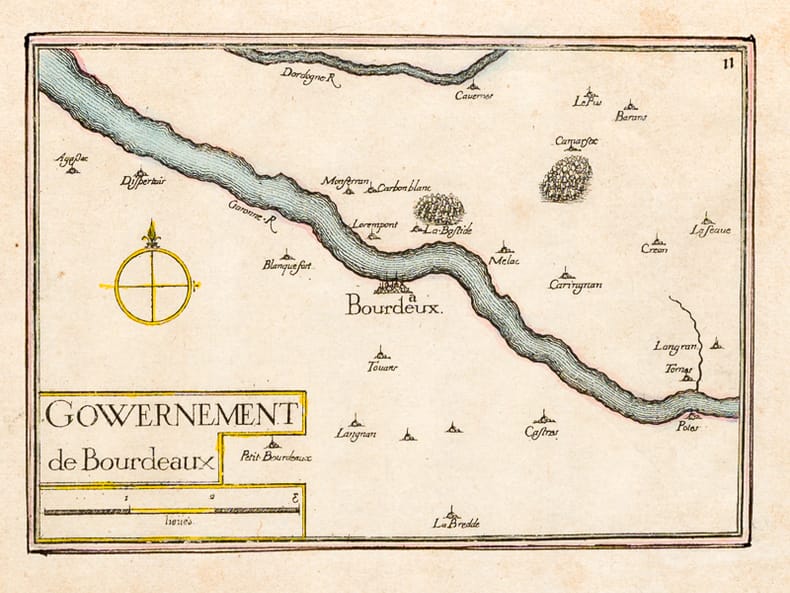
[TASSIN, Nicolas ; TASSIN, Christophe ]
Gouvernement de Bourdeaux [ Carte du Gouvernement de Bordeaux ] [ Edition originale ]
1 carte rehaussée en couleurs sous cadre vitré format 22 x 18,5 cm, gravure format (à vue) 19,5 x 14,5 cm, s.d. [ circa 1634 ]
Ссылка продавца : 62936
|
|
|
[Timbres Magazine]
TIMBRES MAGAZINE - L'OFFICIEL DE LA PHILATELIE n° 99 (Mars 2009)
Revue mensuelle concernant la philatélie : environ 110 pages en couleurs, format 300 x 210 mm, illustrée, brochée couverture couleurs + fiches détachables
Ссылка продавца : LFA01da2
|
|
|
[Timbres Magazine]
TIMBRES MAGAZINE - L'OFFICIEL DE LA PHILATELIE n°60 (Septembre 2005)
Revue mensuelle concernant la philatélie : environ 110 pages en couleurs, format 300 x 210 mm, illustrée, brochée couverture couleurs + fiches détachables
Ссылка продавца : LFA01804
|
|
|
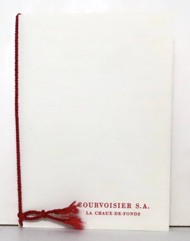
[Timbres]:
4 timbres Helvetia / Pro Juventute.
La Chaux-de-Fonds, Courvoisier, 1957. Ravissante petite plaquette de 4 pages et 2 serpentes, brochée sur cordon et au coeur de laquelle se nichent 4 timbres (non obliétérés) de 1957.
Ссылка продавца : 16628
|
|
|
[TOULON]
Plan de la ville de Toulon indiquant les agrandissements au nord et à l'ouest.
Toulon, Rumèbe, s.d. (c. 1860) 48 x 56, replié au format in-12, sous couverture imprimée. Déchirure à la couverture.
Ссылка продавца : 218540
|
|
|
[United Arab Emirates].
United Arab Emirates 1:50,000 [and] 1:100,000. Abu Dhabi, Military Survey, Armed Forces, 1990-1992.
7 colour printed maps. Scale 1:50,000 and 1:1,000,000. In English and Arabic. Folded. First edition. A set of exceedingly rare UAE topographic maps, compiled from 1:30,000 scale aerial photography taken during 1986 and 1987, presumably based on UK versions. The maps show international boundaries, tracks and paths, bridges, historical landmarks, schools, tree and date plantations, mangroves, oil and gas injection wells, mosques and cemeteries, emergency telephones, water pipelines and tanks, cliffs and rocky areas, as well as other details encountered in the vast desert. Occasionally the average relative height of the dunes is given, reaching up to 45 metres at certain points. - The 6 maps of the 1:50,000 series are sheets number NF-40-01-14, NF-40-01-22, NF-40-01-34, and NF-40-02-11, as well as NG-40-13-54, and NG-40-13-63. The maps of this series "were used extensively for UTM [Universal Transverse Mercator projection coordinate system] Zone 39 rectification. These maps have a local UAE national grid which is equivalent to the UTM grid if a bias of 2,150,000 m in the y-dimension and 150,000 m in the x-dimension are added" (Jensen). The single map of the 1:100,000 series, dating from 1992, is sheet number NG-40-136. - Some pencil marks and circles. The 1:50,000 scaled maps have a stamped six-digit number and a round stamp in Arabic type on the reverse; the 1:100,000 scaled map has a square stamp in Arabic type on the reverse. A few small tears and creases; occasional adhesive tape; paper variously pierced. No copies traceable in libraries internationally. Jensen [et al.], Coastal Environmental Sensitivity Mapping for Oil Spills in the United Arab Emirates [...] 8.
|
|
|
[VACCINATION].-
Paris. Institut Pasteur, la Salle d'Inoculation.-
Carte postale sans nom d'éditeur. Beau plan, très animé, 9 personnes dont l'opérateur et un personnage en uniforme qui semble prendre des notes. Avant 1914. Carte postale (137 x 90mm), écrite au verso, non timbrée. Bel exemplaire.
Ссылка продавца : ORD-10546
|
|
|
[Venedig].
Rialtobrücke mit möbeltransportierender Gondel im Vordergrund. Venedig, um 1890.
Originalfotografie auf strukturiertem Papier. 315:570 mm. Hinter Glas gerahmt. Rahmen mit Originaletikett des Wiener Rahmenmachers Heinrich Klingseis in der Gumpendorferstraße.
|
|
|
[Viennensia - Harmonietheater].
Plan der Umgebung des Orpheum's im Masse 1:720. [Wohl Wien, um 1870].
725:590 mm. Lithogr. Faltplan in 30 Segmenten, auf Leinen aufgezogen. Im originaler goldgepr. Leinenmappe der Wiener Feuerwehr. Von der Feuerwehr der Stadt Wien gedruckter Straßenplan, der die Zufahrt zum Musiktheater "Orpheum" in der Wasagasse sowie die Lage der Hydranten und die Stellplätze für Mannschafts-, Schlauch-, Lösch-, Rüstwagen und Dampfspritze veranschaulicht. Zeigt auch Grundrisse aller Stockwerke des Hauses. Der dargestellte Bereich des 9. Bezirks reicht von der Beethovengasse bis zur Grünentorgasse. - Das 1864/65 von Otto Wagner erbaute Harmonietheater wurde 1866 eröffnet; in diesem Jahr hatte Ludwig Anzengruber unter dem Namen "Gruber" seinen erster Auftritt. Schon 1868 zum "Orpheum" umgestaltet, erlebte das Haus 1872 als "Danzers Orpheum" seine große Blüte. 1900 renoviert und in ein intimes Theater umgestaltet, wurde es 1908 als Sprechbühne mit dem Namen "Neue Wiener Bühne" eröffnet und 1928 geschlossen.

|
|
|
[VILA I DINARÉS, Pau].
Miscel·lània Pau Vila. Biografia. Bibliografia. Treballs d' Homenatge de la Societat Catalana de Geografia. Pròleg per Josep Iglésies.
Granollers, Editorial Montblanc-Martin, 1975. 4to. mayor; 2 hs., 546 pp. Numerosas ilustraciones fotográficas y mapas plegados fuera de texto. Cubiertas originales.

|
|
|
[VIN, CARTES POSTALES]
de Kintzheim à Cleebourg-La route du vin d'alsace, les plus belles cartes postales (die elsassische weinstrasse).
Strasbourg, DIFAL, 1991; in-4, 126 pp., cartonnage de l'éditeur. De Kintzheim à Cleebourg (tome 2) texte bilingue très bon état avec sa jaquette.
Ссылка продавца : 202204346
|
|
|
[VIN, CARTES POSTALES]
La route du vin d'alsace, les plus belles cartes postales (die elsassische weinstrasse).
Strasbourg, DIFAL, 1991; in-4, 126 pp., cartonnage d'éditeur avec jaquette (neuf sous blister). De Kintzheim àà Cleebourg (tome 2) texte bilingue.
Ссылка продавца : 200916116
|
|
|
[VIN, CARTES POSTALES]
La route du vin d'alsace, les plus belles cartes postales (die elsassische weinstrasse).
Strasbourg, DIFAL, 1991; in-4, 126 pp., cartonnage d'éditeur avec jaquette (neuf sous blister). De Kintzheim àà Cleebourg (tome 2) texte bilingue.
Ссылка продавца : 200916114
|
|
|
[VIN, CARTES POSTALES]
La route du vin d'alsace, les plus belles cartes postales (die elsassische weinstrasse).
Strasbourg, DIFAL, 1991; in-4, 126 pp., cartonnage d'éditeur avec jaquette (neuf sous blister). De Kintzheim àà Cleebourg (tome 2) texte bilingue.
Ссылка продавца : 200916113
|
|
|
[VIN, CARTES POSTALES]
La route du vin d'alsace, les plus belles cartes postales (die elsassische weinstrasse).
Strasbourg, DIFAL, 1991; in-4, 126 pp., cartonnage d'éditeur avec jaquette (neuf sous blister). De Kintzheim àà Cleebourg (tome 2) texte bilingue.
Ссылка продавца : 200916112
|
|
|
[VIN, CARTES POSTALES]
La route du vin d'alsace, les plus belles cartes postales (die elsassische weinstrasse).
Strasbourg, DIFAL, 1991; in-4, 126 pp., cartonnage d'éditeur avec jaquette (neuf sous blister). De Kintzheim àà Cleebourg (tome 2) texte bilingue.
Ссылка продавца : 200916111
|
|
|
[VIN, CARTES POSTALES]
La route du vin d'alsace, les plus belles cartes postales (die elsassische weinstrasse).
Strasbourg, DIFAL, 1991; in-4, 126 pp., cartonnage d'éditeur avec jaquette (neuf sous blister). De Kintzheim àà Cleebourg (tome 2) texte bilingue.
Ссылка продавца : 200916110
|
|
|
[VIN, CARTES POSTALES]
La route du vin d'alsace, les plus belles cartes postales (die elsassische weinstrasse).
Strasbourg, DIFAL, 1991; in-4, 126 pp., cartonnage d'éditeur avec jaquette (neuf sous blister). De Kintzheim àà Cleebourg (tome 2) texte bilingue.
Ссылка продавца : 200916109
|
|
|
[VIN, CARTES POSTALES]
La route du vin d'alsace, les plus belles cartes postales (die elsassische weinstrasse).
Strasbourg, DIFAL, 1991; in-4, 126 pp., cartonnage d'éditeur avec jaquette (neuf sous blister). De Kintzheim àà Cleebourg (tome 2) texte bilingue.
Ссылка продавца : 200916108
|
|
|
[VIN, CARTES POSTALES]
La route du vin d'alsace, les plus belles cartes postales (die elsassische weinstrasse).
Strasbourg, DIFAL, 1991; in-4, 126 pp., cartonnage d'éditeur avec jaquette (neuf sous blister). De Kintzheim àà Cleebourg (tome 2) texte bilingue.
Ссылка продавца : 200916107
|
|
|
[VIN, CARTES POSTALES]
La route du vin d'alsace, les plus belles cartes postales (die elsassische weinstrasse).
Strasbourg, DIFAL, 1991; in-4, 126 pp., cartonnage d'éditeur avec jaquette (neuf). De Kintzheim àà Cleebourg (tome 2) texte bilingue.
Ссылка продавца : 200916105
|
|
|
[VIN] MONTORGUEIL Georges; FOREST Louis:
Monseigneur le vin.
Paris, Etablissements Nicolas, 1925-1927. 4 volumes in-8, reliés en 3 volumes, demi-toile lie-de-vin, pièces de titre verte, couvertures conservées; têtes grises.
Ссылка продавца : 19045
|
|
|
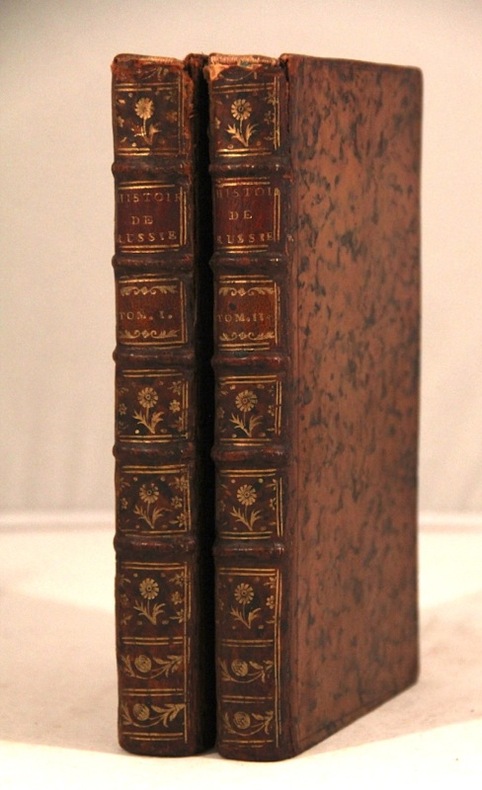
[VOLTAIRE François Marie Arouet]:
Histoire de l'Empire de Russie sous Pierre le Grand, par l'auteur de l'histoire de Charles XII.
sans lieu [Genève], sans nom [Cramer], 1759 - 1763. 2 volumes in-8 de XXXIX, 302p., + [2]ff., XVI, 318p. plein veau marbré brun, dos à nerfs orné de filets et fleurons dorés, pièces de titre et tomaison rouge, coiffes sup. manquantes, mors un peu fendus, tampon répété sur les deux page de titre "L. Derôme". Le titre de la première partie est imprimé en rouge et noir, celui de la seconde partie en noir. Sans l'errata du tome 1er, mais les 3 fautes ont été corrigées.
Ссылка продавца : 5671
|
|
|
[Wien-Plan v. 1547].
Bonifaz Wohlmuth’s Steinmetzten und Baumeister Kaiser Ferdinands I., Grundriss der Stadt-Wien vom Jahre 1547. Gezeichnet von Albert Camesina [...] Herausgegeben durch den Alterthums-Verein zu Wien im Jahre 1857 und 1858. Wien, k. k. Hof- und Staatsdruckerei, 1856-1858.
Farblithographie in 9 Blättern nach der kolorierten Originalfederzeichnung im Historischen Museum der Stadt Wien, bezeichnet “Alb: Camesina fe: 1856”. Auf Leinen als Wandkarte aufgezogen. 188:228 cm. Der von Albert Camesina (1806-1881) lithographierte und in kleiner Auflage gedruckte Plan erschien über zwei Jahre in einzelnen Lieferungen, was - neben dem übergroßen Format der Wandkarte und der verhältnismäßig kleinen Auflage - einen der Hauptgründe für seine Seltenheit darstellt. Der Wienplan des Mitarbeiters Augustin Hirschvogels Bonifaz Wolmut “stellte eine Kombination von ausgeführten und projektierten Festungsanlagen zur Diskussion. Darüber hinaus ergeben die detaillierte Wiedergabe des Grundrisses der Innenstadt [...] und die in freier Perspektive festgehaltenen Vorstadtränder eine grundlegende Dokumentation Wiens (Wien im Mittelalter, Kat. des Historischen Museums der Stadt Wien, 1975/6, Nr. 364). - Nur zwei der neun Segmente unbedeutend fleckig, am rechten unteren Rand etwas bestoßen, im Ganzen aber von sehr ansprechender Erhaltung. Fischler, Historischer Atlas des Wiener Stadtbildes, 12f. Oppl, Wien im Bild historischer Karten, Tafel 5.

|
|
|
[Wien-Plan v. 1547].
Bonifaz Wohlmuth’s Steinmetzten und Baumeister Kaiser Ferdinands I., Grundriss der Stadt-Wien vom Jahre 1547. Gezeichnet von Albert Camesina [...] Herausgegeben durch den Alterthums-Verein zu Wien im Jahre 1857 und 1858. Wien, k. k. Hof- und Staatsdruckerei, 1856-1858.
Farblithographie in 9 Blättern nach der kolorierten Originalfederzeichnung im Historischen Museum der Stadt Wien, bezeichnet "Alb: Camesina fe: 1856". Einzeln unter Passepartouts montiert. Jeweils 700:850 mm. Der von Albert Camesina (1806-1881) lithographierte und in kleiner Auflage gedruckte Plan erschien über zwei Jahre in einzelnen Lieferungen, was - neben dem übergroßen Format und der verhältnismäßig kleinen Auflage - einen der Hauptgründe für seine Seltenheit darstellt. Der Wienplan des Mitarbeiters Augustin Hirschvogels Bonifaz Wolmut “stellte eine Kombination von ausgeführten und projektierten Festungsanlagen zur Diskussion. Darüber hinaus ergeben die detaillierte Wiedergabe des Grundrisses der Innenstadt [...] und die in freier Perspektive festgehaltenen Vorstadtränder eine grundlegende Dokumentation Wiens (Wien im Mittelalter, Kat. des Historischen Museums der Stadt Wien, 1975/6, Nr. 364). - Tadelloses u. fleckenfreies, in den originalen Einzelsegmenten erhaltenes Exemplar. Fischler, Historischer Atlas des Wiener Stadtbildes, 12f. Oppl, Wien im Bild historischer Karten, Tafel 5.

|
|
|
[Wien].
Vue de Vienne prise du coté du chateau de Schönbrunn. Paris, Guérin, ca. 1830.
Kolorierte Umrissradierung. Unter Glas gerahmt. 630:840 mm. Prachtvolle Gesamtansicht der Stadt Wien, von der Westseite gezeichnet von Högl, gest. von Schwartz. - Ansprechendes, großformatiges Blatt im Originalkolorit der Zeit.

|
|
|
[Yemen].
Manuscript map of Yemen Vilayet. [Probably Istanbul, ca. 1915].
Ca. 230 x 190 mm. Original hand-coloured map on tissue paper. In Ottoman script and Arabic. Hand-drawn map of the Yemen vilayet, distinctly outlining the sanjaks of Sana'a, Ta'izz, Hudeyde, and Asir, bordered by the Arabian Desert, the Hejaz vilayet, the Red Sea, and the Umman Sea. Maps such as this, executed on thin tracing paper, were commonly made as educational tools at elite Ottoman schools and universities during the early 20th century, although few such specimens survive. The manuscript notes suggest that the map was used for military purposes during the last Ottoman imperial period. - At the beginning of the 20th century, the vilayet covered an area of 200,000 square kilometers, its population having reached 2,500,000 by 1885. When World War I broke out, Imam Yahya remained nominally loyal to the Sultan but at the same time strove to negotiate with Britain. Turkish forces withdrew in 1918, and Imam Yahya strengthened his control over northern Yemen, creating the Mutawakkilite Kingdom of Yemen. - Very well preserved.
|
|
|
[YOUGOSLAVIE]:
Royaume de Yougoslavie 1919-1929.
Beograd, Bureau central de presse auprès de la présidence du conseil des ministres, 1930. In-8 broché de LXIV-48 pages. couverture de papier fort, écru, orné des armes du Royaume.
Ссылка продавца : 20709

|
|
|
[ZURLAUBEN Beat Fidel Anton von]:
Tableaux de la Suisse ou voyage pittoresque fait les treize cantons et états alliés du corps helvétique.
Genève, Slatkine, 1977. 4 volumes grand in-folio de [12]-10-[2]-134-[4]; [6]-p.135 à 368-LXVI-[2]; [8]-322-[2] et [6]- p. 323 à 578-[4]-II-7-8-129 (table analytique) pages, plein skyvertex vert, dos lisses ornés de roulettes, encadrements, fleurons, titre et tomaison dorés, étiquettes de titre et tomaison noires, triple roulettes dorées ornant les plats. Un coin un peu tapé, pour le reste en belle condition.
Ссылка продавца : 9738

|
|
|
A cura di D. Salvadori Guidi.
Guida alla scoperta delle opere d?arte del ?900 a Firenze. Progetto IRRSAE Toscana.
cm. 17 x 24, xxvi-262 pp. con 171 ill. in b.n. e 83 a col. n.t. Cultura e memoria L'opera ? preceduta da una parte introduttiva che consente un inquadramento storico-artistico sulla situazione fiorentina e toscana delle arti visive di questo secolo. Il lavoro ? organizzato in schede, relative a collezioni o singole opere, in cui sono riportati dati generali, notizie storico-artistiche, dati tecnici e descrizioni semplici, che consentono per? anche una lettura formale, sia pur breve, delle opere. Le schede sono suddivise per quartieri, all'interno di ognuno dei quali esse sono segnalate secondo un percorso indicato in una cartina allegata. This work is preceded by an introduction giving an historical artistic outline of the Florentine and Tuscan situation of this century's visive art. The work is organized in cards, relating to collections or single works, providing general information, historical artistic notes, technical data and simple descriptions which permit a formal reading, even if brief, of the works themselves. The cards are divided into districts where the actual works are to be found according to an itinerary marked out on an enclosed map. 780 gr. xxvi-262 p.
|
|
|
A cura di D. Salvadori Guidi.
Guida alla scoperta delle opere d?arte del ?900 nella provincia di Firenze. Progetto IRRSAE Toscana.
cm. 17 x 24, xvi-214 pp. con 62 ill. a colori, 129 in b.n. e 1 pieghevole. Cultura e memoria Questo lavoro si presenta come una guida organizzata in ordine alfabetico per Comuni, all?interno dei quali si indica un itinerario preferenziale e possibile, che invita alla scoperta delle opere dal ?900 a oggi presenti nel territorio della provincia in luoghi visitabili. Offre una documentazione variata e ampia sulle modalit? con cui si muove il territorio della provincia nei confronti del mondo artistico contemporaneo locale e non. A guide book offering preferential and possible itineraries through the various Communes, listed in alphabetical order, inviting one to discover works of art of the early 20th century to the present day. A vast and as yet unpublished selection of documents of these works of art to be found in the Province of Florence. 575 gr. xvi-214 p.
|
|
|
A Field-Officer of Cavalry [Sir Digby Mackworth]:
Diary of a Tour Through Southern India, Egypt, and Palestine, in the Years 1821 and 1822.
London, J. Hatchard and Son, 1823. In-8 de VIII-372 pages, plein veau à grains long caramel, dos à nerfs orné de filets dorés, pièce de titre noire, tranches mouchetées rouge. Un petite accroc au premier plat et une légère fente au second mors.
Ссылка продавца : 16001
|
|
|
A Guide to the Civil War Maps in the National Archives National Archives Archives
A Guide to the Civil War Maps in the National Archives National
New. unknown
Ссылка продавца : 12114-122 ISBN : 0911333363 9780911333367
|
|
|
 Получить результаты поиска по электронной почте
 Загрузить результаты в формате PDF
  RSS-канал


