|
Author Not Stated
Rand, McNally & Co.'s 1895 Map of the Main Portion of Minneapolis
Outside dimensions 14.5" x 10.5" Circa 1902. Centerfold. Light wear. Please see our photo for details. Book

|
|
|
Author Not Stated
Rand, McNally & Co.'s 1895 Map of the Main Portion of Baltimore, Maryland - in Colour
Railroads and street car lines indicated. Outside dimensions 14.5" x 10.5" Circa 1902. Centerfold. Light wear. Please see our photo for details. Book

|
|
|
Author Not Stated
Rand, McNally & Co.'s 1901 Colour Map of the State of Oklahoma and Indian Territory
Outside dimensions 14.5" x 10.5". Circa 1902. Centerfold. Light wear. Please see our photo for details. Book

|
|
|
Author Not Stated
Rand, McNally & Co.'s 1901 Colour Map of the State of Rhode Island
Outside dimensions 14.5" x 10.5". Circa 1902. Centerfold. Light wear. Please see our photo for details. Book

|
|
|
Author Not Stated
Rand, McNally & Co.'s 1901 Colour State Map of Florida
Outside dimensions 14.5" x 10.5". Circa 1902. Centerfold. Light wear. Please see our photo for details. Book

|
|
|
Author Not Stated
Rand, McNally & Co.'s 1901 Map of the "Western Portion of Oklahoma"/ Indian Territory and Oklahoma
Outside dimensions 14.5" x 10.5". Circa 1902. Centerfold. Light wear. Please see our photo for details. Book

|
|
|
Author Not Stated
Rand, McNally & Co.'s 1901 State Map of Illinois - In Colour
Outside dimensions 14.5" x 10.5". Circa 1902. Centerfold. Light wear. Some soiling to lower left corner. Please see our photo for details. Book

|
|
|
Author Not Stated
Rand, McNally & Co.'s 1901 State Map of Indiana - In Colour
Outside dimensions 14.5" x 10.5". Circa 1902. Centerfold. Light wear. Please see our photo for details. Book

|
|
|
Author Not Stated
Rand, McNally and Co.'s 1895 Colour Map of the State of Pennsylvania
Outside dimensions 14.5" x 10.5" Circa 1902. Centerfold. Light wear. Please see our photo for details. Book

|
|
|
Author Not Stated
Rand, McNally and Co.'s 1901 Colour Map of the Main Portion of Boston, Massachusetts
Outside dimensions 14.5" x 10.5". Circa 1902. Centerfold. Light wear. Please see our photo for details. Book

|
|
|
Author Not Stated
River Engineering Plate - Circa 1902
Outside dimensions 14.5" x 10.5". Circa 1902. Displays details of: The River Tyne; The River Seine; The River Maas; The Mississippi Delta; The Delta of the Danube; and more. Centerfold. Light wear. Please see our photo for details. Book

|
|
|
Author Not Stated
Sketch Map Showing the Administrative and Political Divisions of the Dominions of the Hungarian Crown According to Article XXXIII of the Legislature of the Year 1876
Outside dimensions 14.5" x 10.5". Circa 1902. Centerfold. Light wear. Bit of soiling along top edage. Please see our photo for details. Book

|
|
|
Author Not Stated
The Canadian Thresherman and Farmer Handy Atlas of The World
120 pages consisting of 89 pages of colour maps of the world, several colour diagramatic graphs, etc., and 25 pages of textual data including distances, historical items, cities and towns. The Canadian Thresherman and Farmer was published in Winnipeg from 1910 to 1919 by E.H. Heath and billed itself as 'Canada's Farm Machinery Magazine'. One can well imagine this atlas was intended to offer a view of the distant world to isolated farmers toiling on the vast expanse of Canadian prairie. Includes a detailed two-page map and profile of the newly completed engineering marvel known as the Panama Canal. Occasional ink writing to contents. Hinges open. Name atop front free endpaper. Somewhat above-average wear to publisher's maroon cloth. A worthy and uncommon surviving copy of this vintage Canadian atlas. Book

|
|
|
Author Not Stated
The Forum Romanum - and Its Surrounding Buildings
Outside dimensions 14.5" x 10.5". Circa 1902. Centerfold. Light wear. Please see our photo for details. Book

|
|
|
Author Not Stated
The Official Illustrated Guide to the District Adjacent to the North Staffordshire Railway / Picturesque Staffordshire and Surrounding Districts - Rambles on the Hills and in the Valleys
XIV, 154 pages. Index. Six nice maps plus one more on back cover. Printed upon glossy stock. Many nice black and white photos. "The main idea has been to dispel, by means of facts and photographs, the notion held by many people that the county is 'bleak and stony'." - from Preface. Above-average external wear and soiling. Unmarked. A worthy vintage copy. Book

|
|
|
Author Not Stated
The Tartan Map - With List of Septs of the Clans
Folds out to measure approximately 40"x30". Average wear. Unmarked. Attractive and interesting reference. Circa 1975? Book

|
|
|
Author Not Stated
Two Maps of the Kingdom of Prussia: 1786 and 1866
Outside dimensions 14.5" x 10.5". Circa 1902. Centerfold. Light wear. Please see our photo for details. Book

|
|
|
Author Not Stated
Vacation Guidebook 1963-1964: The Exclusive Guidebook to Northern Ontario
80 pages. Provides colour maps and information on accommodation, entertainment, bush pilots, fishing regulations, and more. Dozens of great vintage ads for related local businesses. Nice colour photo ad for Thitfield Lodge, Hotel & Motel inside front cover. Back cover ad for Sudbury sponsored by their Chamber of Commerce features colour photo of molten slag being poured with belching smokestacks in background (Say what?). Other nice ads for Caswell Motor Hotels, Rusty Myers Flying Service, Camp Beaverhead, Camp Manitou, Dalseg's Shopping Centre, Swenson's Camp, Sabourin Lake Lodge (in colour), Barney's Ball Lake and God's Lake Lodges, Doug Hook's Separation Lake Camp, Sault Airways, Wawa's Lakeview Hotel, The Kitchener Hotel in Parry Sound, Moose Lake Lodge, Eden Roc Motel, Larry's Tavern in Pointe Au Baril, Red Pines Lodge, and dozens more. Somewhat above-average wear. Bit of writing atop front cover and small bookseller's stamp inside back cover. A great vintage item sure to help readers recount happy vacation times spent in Northern Ontario many moons ago. Book

|
|
|
Author Not Stated
Visitor's Guide: Victoria, Vancouver Island, Vancouver - Sightseeing Maps
64 pages. Undated but appears to be early 1960s. Many colour photos and other illustrations. Provides a comprehensive snapshot of the many tourist attractions and services of these areas several decades ago. Unmarked with average wear. A great piece for those interested in the history of the tourism industry in these regions. Book

|
|
|
Automobile Association/Macmillan
Corfu and the Ionian Islands Traveller's Map Including a Plan of Corfu Town
London: Macmillan Folded Map. As New. Map. Macmillan paperback
書籍販売業者の参照番号
: 12591 ISBN : 0749500646 9780749500641
|
|
|
Automobile Association/Macmillan
Malta and Gozo Traveller's Map Includingplans of Valletta Sliema and St.Paul's Bay
London: Macmillan Folded Map. As New. Map. Macmillan paperback
書籍販売業者の参照番号
: 19538 ISBN : 074950062X 9780749500627
|
|
|
AUTOMOBILE MAPS ADVERTISING.
Motor map of England & Wales. Scale and reference to sectional maps. Perrier. French natural sparkling table water obtainable at every good hotel and club in the world by Special Appointment to H.M. King George V.
London: George Philip & Son Ltd. ca. 1920. 4to. 15 colour maps & 1 distance timetable 12 retaining Perrier tabs at upper fore-edge printed on thick stock including index map to card sections w/ Perrier advertising on borders and map showing principal roads leading through and out of London. Preserved in original wooden travel case covered in green cloth w/ flap & two black snaps early plastic window mounted in front to display the maps Perrier lettering in silver & red on front & back minor rubbing & corners some minor fraying at hinges of flap very minor scuffing still a VG piece. First edition thus of this scarce promotional advertising Jazz Era automobile map by Perrier sparkling water. The maps show the trunk roads main roads smaller tracks railways & stations distances from London marked in black and the distances between towns marked in red. The maps appear to date around 1920 and before 1923 or so when maps and atlases published by George Philip & Son began using the British letter & number classification system. The earlier versions of the Perrier advertising motor maps were sectional maps mounted on linen that could be folded and those date prior to the ascension of George V to the throne. A wonderful piece of early Automobilia and Perrier promotions. George Philip & Son, Ltd., hardcover
書籍販売業者の参照番号
: 46424
|
|
|
AUTOMOBILES: MAPS
The Photomobile Tourist; Oregon Washington Idaho.
Seattle: Photomobile Tourist Company 1919. First edition. Tall octavo. 416 pp. with photographs ads and text on every page. Publisher's flexible red cloth with gilt lettering to spine and front cover. A very good and clean copy with minor extremity wear.In 1919 automobile travel over distances was a challenge due to poor roads and a real lack of signage. This book provides the automobilist a guide to destinations in the Pacific Northwest using both words and photographic images The images in essence were the real guide on where to turn and what to see as road signs were very few and far between. They are laid out in the format of a piece of a film along the inner margins showing the driver the path by way of visual keys. "The road data is presented in the most interesting manner ever conceived. The marginal pictures are faithful reproductions of actual photographs taken from an automobile and represent in minute detail mile after mile of the road as the driver sees it. The Photomobile Tourist is more than a mere road guide; it is a perpetual reminder of the run over every every trip it covers and its memoranda pages give it a cumulative personal interest as a pictorial diary" From the introduction. In many ways it is a guidebook to the ghost roads of the West as when the street and highway roads improved with age these old trails likely became abandoned or were relegated to being mere roads. Although it proclaim to be a guide for "Oregon Washington and Idaho" the book also eccompasses British Columbia and Montana and Yellowstone. The book also contains full page maps but they are mainly of psychological importance A plethora of ads for local businesses are interspersed throughout and well lengthy descriptive prose passages extolling the glory of the Northwest. OCLC located 13 copies. Photomobile Tourist Company hardcover
書籍販売業者の参照番号
: 74508
|
|
|
Automobile Association
AA Road atlas of Great Britain
Elephant folio, 92 pages, colour maps. Covers creased. eng
|
|
|
Automobile Association
Bristol Street By Street
16mo, 172 pages, colour maps. eng
|
|
|
Automobile Association/Macmillan
Corfu and the Ionian Islands Traveller's Map, Including a Plan of Corfu Town
Large fold-out map Scale 1"1000 Map
|
|
|
Automobile Association/Macmillan
Malta and Gozo Traveller's Map, Including plans of Valletta, Sliema and St.Paul's Bay
A large-scale map designed to help visitors to plan their holidays and explore Malta and Gozo. It contains town plans, hotels and details of local amenities and places of interest. Information in English, Deutsch, Italiano, Franc?ais Undated c.2004? Map
|
|
|
AUTRIVE Valérie
"Votre avenir en 32 cartes; des révélations directes, des méthodes de voyance infaillibles, acquérir une maîtrise parfaite."
Paris, Editions Trajectoire, 2000. 16 x 24, 303 pp., très nombreuses figures, 2 tableaux, broché, très bon état.
書籍販売業者の参照番号
: 49174
|
|
|
AUTUN
Carte allemande.
1 feuille 80x66 cm. Tache en marge.
|
|
|
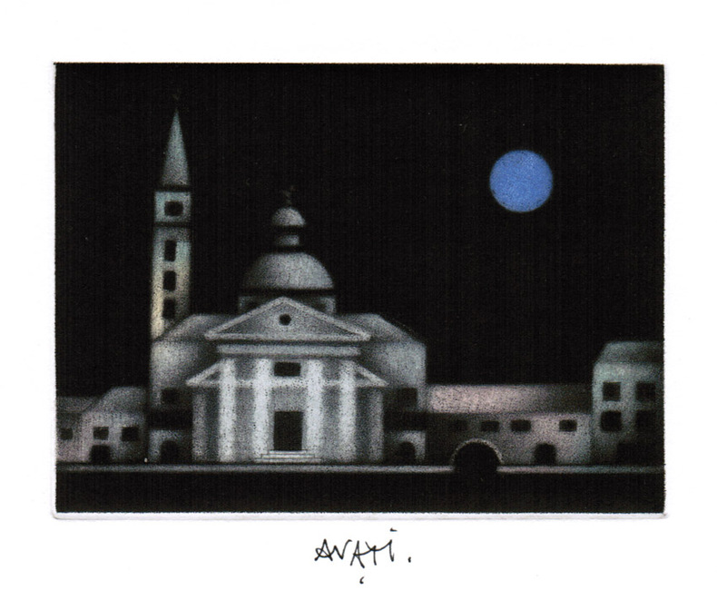
AVATI (Mario).
Carte de voeux illustrée d'une gravure originale signée.
Paris Galerie Sagot-Le Garrec 1980 1 vol. Broché Carte de voeux dépliante sur Arches illustrée d'une belle eau-forte en couleurs (13 x 17 cm) signée par Avati. En parfait état.
書籍販売業者の参照番号
: 109147
|
|
|
AVATI (Mario).
Carte de voeux illustrée d'une gravure originale signée.
Paris Galerie Sagot-Le Garrec 1980 1 vol. Broché Carte de voeux dépliante sur Arches illustrée d'une belle eau-forte en couleurs (13 x 17 cm) signée par Avati. En parfait état.
書籍販売業者の参照番号
: 109147
|
|
|
Avati, Mario
Carte de voeux pour 1992 : gravure à la manière noire
1992 Gravure en couleurs à la manière noire tirée en carte de voeux. 149 x 122 mm, sujet : 119 x 89 mm, signée à la plume, mention "Bon [sic] année 1992" à la plume au premier plat.
書籍販売業者の参照番号
: 1893
|
|
|
Avec Cartes Michelin
Le Guide Illustré De La France
France loisirs Sans date.
書籍販売業者の参照番号
: 500128836

|
|
|
AVELINE "il vecchio" Pierre (Pargi 1656 circa - 1722)
Profil de la Ville de Rome
Panorama di Roma preso dal Gianicolo, firmata "Aveline fecit et excudit", edita a Parigi presso Charpentier."La veduta panoramica di Roma è presa dal Gianicolo e raffigura sulla sinistra il complesso del Vaticano e Castel Sant'Angelo. AL centro il fitto tessuto urbano cittadino dal quale emergono torri e cupole non sempre riconoscibili. L'intera veduta è infatti condotta con grafia molto essenziale e immediata di non grande impatto visivo" (cfr. Barbara Jatta in "Roma Veduta" p. 193). La veduta viene attribuita dalla Jatta - soprattutto per motivi temporali legati all'editore Charpentier crediamo - ad Antoine Aveline "il giovane". La famiglia Aveline, appartenente alla borghesia parigina, lavorò per oltre due secoli nel campo artistico ed incisorio; visto il ripetersi dei nomi di battesimo e il fatto che apponevano la generica firma Aveline, si è spesso fatta confusione fra i sui vari componenti. Tuttavia l'imprint Aveline fecit et excudit lascia credere che l'edizione Charpentier sia il secondo stato (di tre) della lastra, che in seguito fu ristampata anche da Chereau. Quindi riteniamo più probabile - anche per lo stile grafico - attribuirla a Pierre Aveline e la data di stampa posta a circa il 1720 circa. Particolare curioso, la veduta non include il Colosseo. Nel margine inferiore, legenda di 47 numeri. Acquaforte, con ampli margini, consueta piega centrale, sporadiche e piccole ossidazioni nei margini bianchi nel complesso in ottimo stato di conservazione. Panorama of Rome taken from the Janiculum Hill, signed "Aveline fecit et excudit", published in Paris at Charpentier. The panoramic view of Rome is taken from the Janiculum Hill and depicts on the left the Vatican complex and Castel Sant'Angelo. At the center the dense urban fabric from which towers and domes emerge not always recognizable. The entire view is in fact conducted with very essential and immediate handwriting of not great visual impact (see Barbara Jatta in "Roma Veduta" p. 193). The view is attributed by Jatta to Antoine Aveline "the young". The Aveline family worked for over two centuries in the field of art and engraving; given the repetition of first names and the fact that they affixed the generic signature Aveline, there has often been confusion among the various members. However, the imprint Aveline fecit et excudit leads us to believe that the Charpentier edition is the second state (of three) of the plate, which was later reprinted also by Chereau. Therefore we think it more probable - also for the graphic style - to attribute it to Pierre Aveline and the date of printing placed at about 1720. Curious detail: the view does not include the Colosseum. In the lower margin, legend of 47 numbers. Etching, with wide margins, usual central fold, sporadic and small oxidations in the white margins, on the whole in very good condition. Arrigoni Bertarelli (1939): p. 20, n. 154; B. Jatta in "Roma Veduta", p. 193, n. 45; Marigiiani (2007), p. 262, n. 175.

|
|
|
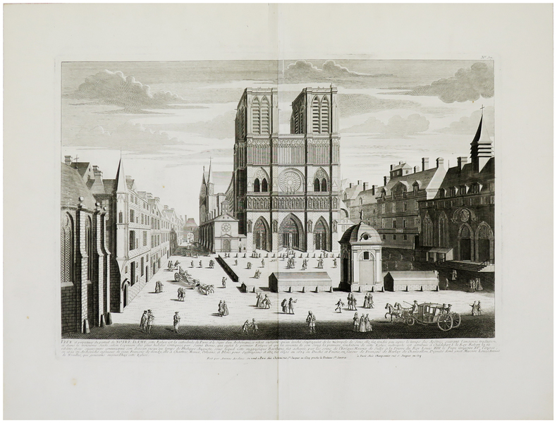
AVELINE (Antoine) & CHÉREAU (Jacques).
Veûe et perpectives du portail de Notre Dame.
Paris, Chéreau, [circa 1740]. 352 x 508 mm.
書籍販売業者の参照番号
: LBW-962
|
|
|
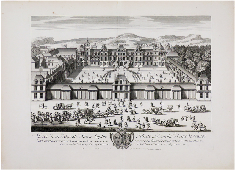
AVELINE (Antoine).
[FONTAINEBLEAU] Veuë et perspective du château de Fontainebleau du côté de l'entrée de la Cour du Cheval Blanc.
[circa 1740]. 380 x 510 mm.
書籍販売業者の参照番号
: LBW-6532
|
|
|
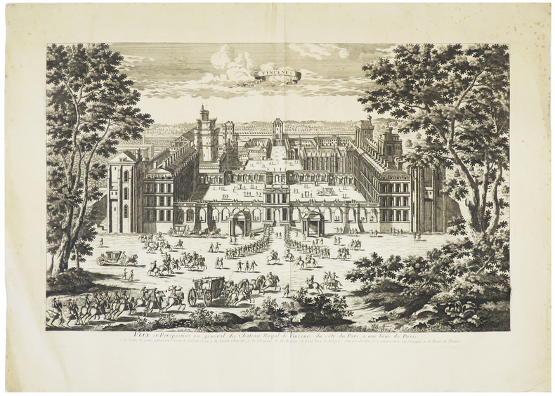
AVELINE (Antoine).
[VINCENNES] Veüe et perspective en général du château royal de Vincenes, du côté du parc à une lieüe de Paris.
Paris, [circa 1740]. 333 x 516 mm.
書籍販売業者の参照番号
: LBW-5738
|
|
|
AVELINE (Antoine).
Veûe et perspectives du portail de Notre Dame.
[circa 1740]. 352 x 511 mm.
書籍販売業者の参照番号
: LBW-3228
|
|
|
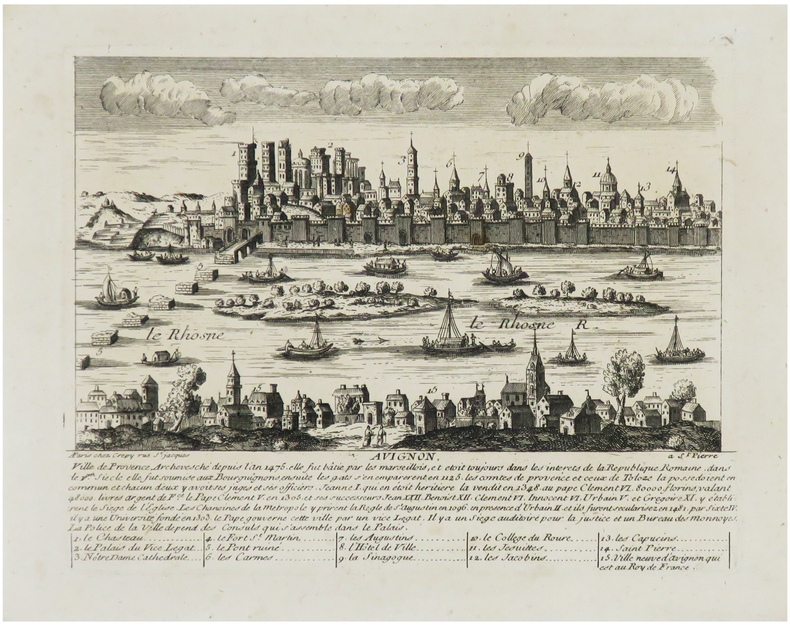
AVELINE (Pierre) & CRÉPY (Louis).
[AVIGNON] Avignon, ville de Provence, archevesché depuis l'an 1475.
Paris, Crépy, [circa 1720]. 176 x 204 mm.
書籍販売業者の参照番号
: LBW-6830
|
|
|
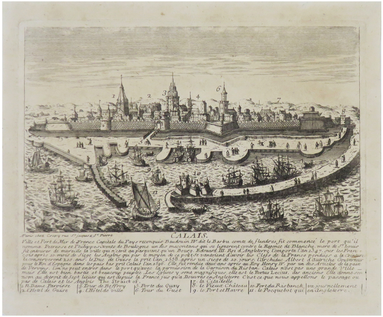
AVELINE (Pierre) & CRÉPY (Louis).
[CALAIS] Calais, ville et port de mer de France, capital du Pays reconquis.
Paris, Crépy, [circa 1720]. 176x 230 mm.
書籍販売業者の参照番号
: LBW-6818
|
|
|
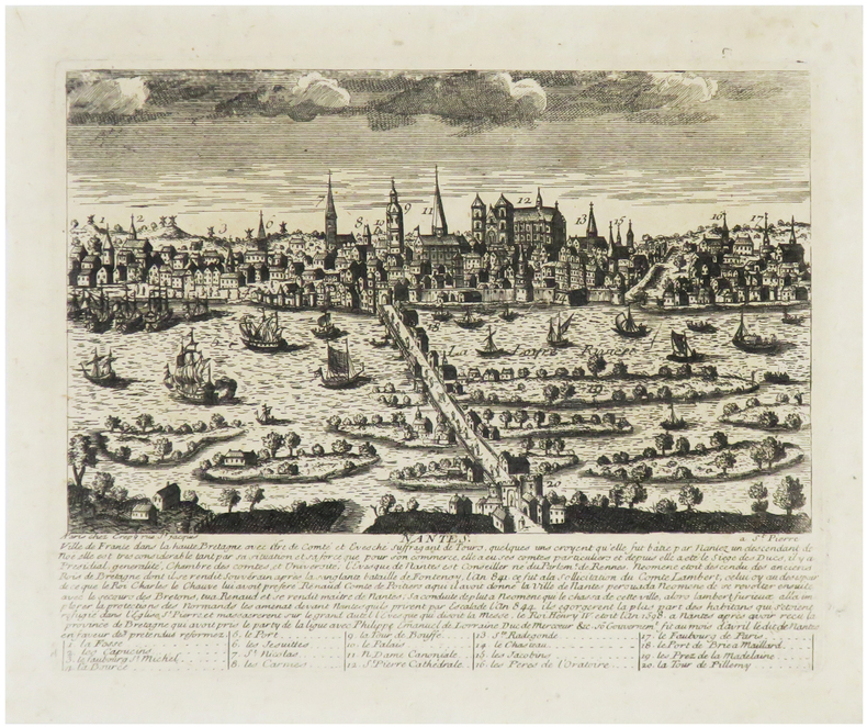
AVELINE (Pierre) & CRÉPY (Louis).
[NANTES] Nantes, ville de France dans la haute Bretagne.
Paris, Crépy, [circa 1720]. 176x 220 mm.
書籍販売業者の参照番号
: LBW-6814
|
|
|
AVELINE (Pierre) & CRÉPY (Louis).
[VENISE] Venise, ville d'Italie et république souveraine du golfe qui porte son nom.
Paris, Crépy, [circa 1720]. 166x 212 mm.
書籍販売業者の参照番号
: LBW-6862

|
|
|
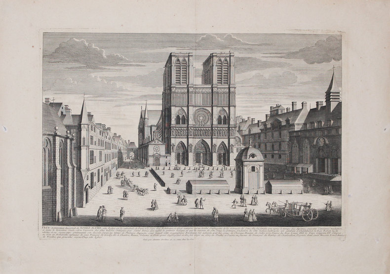
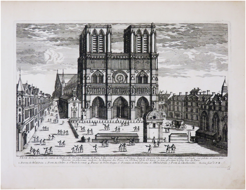
AVELINE (Pierre).
[NOTRE-DAME] Veue de la principale entrée de l'église de Nôtre Dame de Paris, bâtie sous le règne de Philippe Auguste environ l'an 1200.
[circa 1690]. 207 x 305 mm.
書籍販売業者の参照番号
: LBW-7969
|
|
|
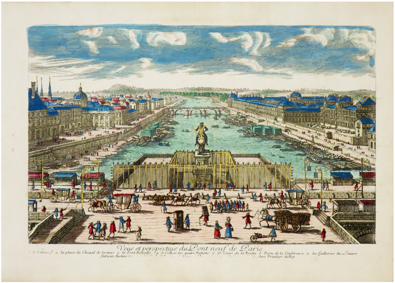
AVELINE (Pierre).
[PONT-NEUF] Veüe et perspective du Pont Neuf de Paris.
[circa 1690]. 166x 212 mm.
書籍販売業者の参照番号
: LBW-6971
|
|
|
AVELINE (Pierre).
Constantinople ville de Romanie et capitale de l'empire des Turcs.
[1692]. 206 x 317 mm.
書籍販売業者の参照番号
: LBW-706

|
|
|
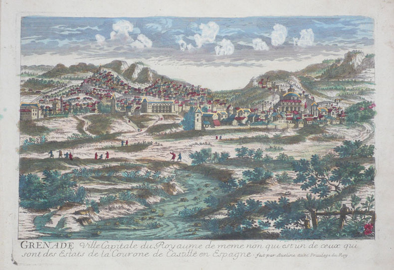
AVELINE (Pierre).
Grenade ville capitale du royaume de meme non qui est un de ceux qui sont des estats de la Courone de Castille en Espagne.
[circa 1690]. 215 x 313 mm.
書籍販売業者の参照番号
: LBW-946
|
|
|
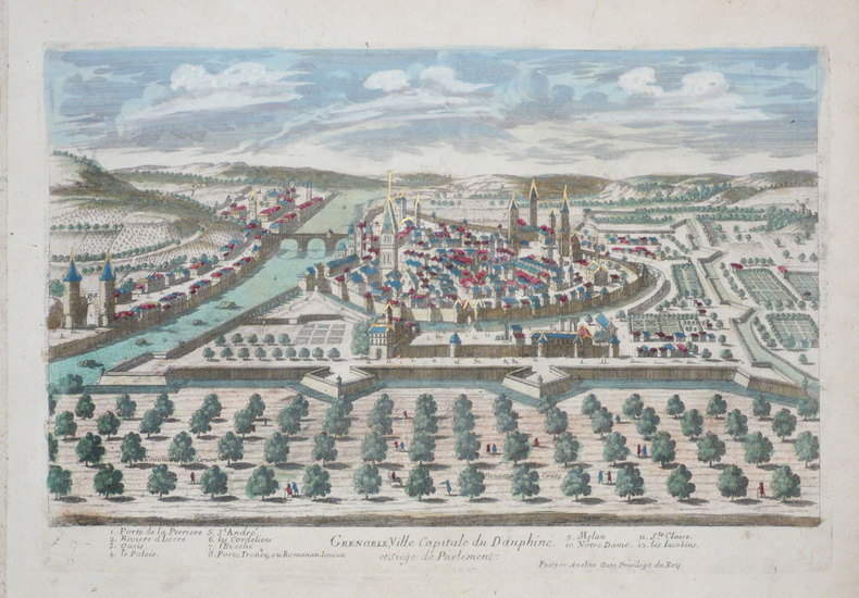
AVELINE (Pierre).
Grenoble, ville capitale de Dauphiné et siège de parlement.
[circa 1690]. 212 x 312 mm.
書籍販売業者の参照番号
: LBW-1287
|
|
|
AVELINE (Pierre).
Inspruck ville d’Allemagne capitale du comté de Tirol.
[circa 1695]. 209 x 307 mm.
書籍販売業者の参照番号
: LBW-793

|
|
|
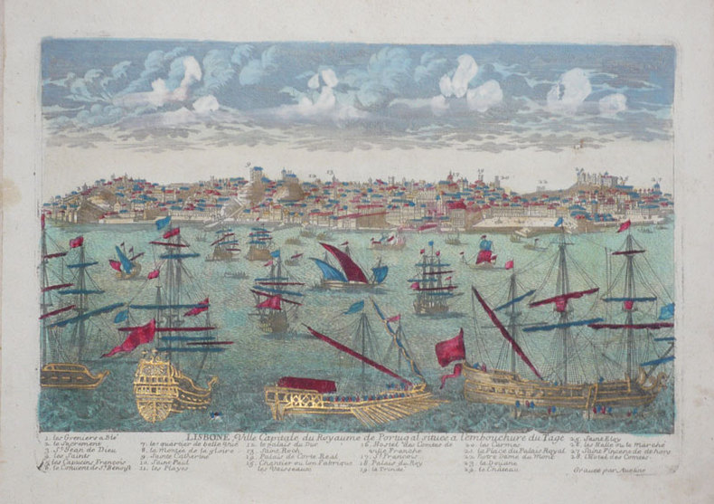
AVELINE (Pierre).
Lisbone, ville capitale du royaume de Portugal située à l'embouchure du Tage.
[circa 1690]. 210 x 305 mm.
書籍販売業者の参照番号
: LBW-945
|
|
|
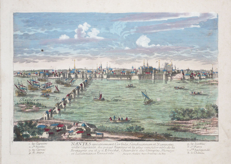
AVELINE (Pierre).
Nantes ancienement Corbilo, Condivineum et Namnetes, ville capitale du pays nantois et la plus considérable de la Bretagne ou il y a Eveché, Chambre des Comptes, Monoye et Lieutenance Générale.
[circa 1690]. 216 x 309 mm.
書籍販売業者の参照番号
: LBW-1286
|
|
 検索結果のメールを受信する
 PDFファイルの検索結果をダウンロード
 RSSフィード


