|
Bellin Jacques Nicolas Pugsley William H. William Howard WH. Pugsley Collection of Early Canadian Maps W. H.
Carte reduite du Golphe de St. Laurent : contenant l'Isle de Terre-Neuve et partie de la Coste des Esquimaux l'Isle Royale l'Isle St. Jean et celle d'Anticosti & ca. 1754
2019. Paperback. New. Lang: - French. Reprinted in 2019 with the help of original edition published long back 1754. This book is Printed in black & white sewing binding for longer life with Matt laminated multi-Colour Soft Cover HARDCOVER EDITION IS ALSO AVAILABLE Printed on high quality Paper re-sized as per Current standards professionally processed without changing its contents. As these are old books we processed each page manually and make them readable but in some cases some pages which are blur or missing or black spots. If it is multi volume set then it is only single volume if you wish to order a specific or all the volumes you may contact us. We expect that you will understand our compulsion in these books. We found this book important for the readers who want to know more about our old treasure so we brought it back to the shelves. Any type of Customisation is possible with extra charges. Hope you will like it and give your comments and suggestions. paperback
Referenz des Buchhändlers : PB1111007010922
|
|
|
Bellin Jacques Nicolas Pugsley William H. William Howard WH. Pugsley Collection of Early Canadian Maps W. H.
Carte reduite du Golphe de St. Laurent : contenant l'Isle de Terre-Neuve et partie de la Coste des Esquimaux l'Isle Royale l'Isle St. Jean et celle d'Anticosti & ca. 1754 Hardcover
2019. Hardcover. New. Lang: - French. Reprinted in 2019 with the help of original edition published long back 1754. This book is Printed in black & white Hardcover sewing binding for longer life with Matt laminated multi-Colour Dust Cover Printed on high quality Paper re-sized as per Current standards professionally processed without changing its contents. As these are old books we processed each page manually and make them readable but in some cases some pages which are blur or missing or black spots. If it is multi volume set then it is only single volume if you wish to order a specific or all the volumes you may contact us. We expect that you will understand our compulsion in these books. We found this book important for the readers who want to know more about our old treasure so we brought it back to the shelves. Any type of Customisation is possible with extra charges. Hope you will like it and give your comments and suggestions. hardcover
Referenz des Buchhändlers : 1111007010922
|
|
|
Bellin Jacques Nicolas France. Depot des cartes et plans de la marine France. Ministere de la marine. fmo RIBRL
Observations sur la Carte de l'isle de Saint Domingue et de ses débouquemens : dressée au Dépôt des plans de la Marine pour le service des vaisseaux du roy. Par ordre de M. Rouillé secretaire d'etat ayant le département de la Marine 1750 1750 Leather Bound
2019. Leather Bound. New. Leather Binding on Spine and Corners with Golden Leaf Printing on round Spine. Reprinted in 2019 with the help of original edition published long back 1750. This book is printed in black & white sewing binding for longer life Printed on high quality Paper re-sized as per Current standards professionally processed without changing its contents. As these are old books we processed each page manually and make them readable but in some cases some pages which are blur or missing or black spots. If it is multi volume set then it is only single volume if you wish to order a specific or all the volumes you may contact us. We expect that you will understand our compulsion in these books. We found this book important for the readers who want to know more about our old treasure so we brought it back to the shelves. Hope you will like it and give your comments and suggestions. Lang: - fre Pages 18. EXTRA 10 DAYS APART FROM THE NORMAL SHIPPING PERIOD WILL BE REQUIRED FOR LEATHER BOUND BOOKS. FOLIO EDITION IS ALSO AVAILABLE. hardcover
Referenz des Buchhändlers : LB1111008296610
|
|
|
Bellin Jacques Nicolas Pugsley William H. William Howard donor WH. Pugsley Collection of Early Canadian Maps Homann Erb
Partie occidentale de la Nouvelle France ou du Canada 1755 Leather Bound
2019. Leather Bound. New. Leather Binding on Spine and Corners with Golden Leaf Printing on round Spine extra customization on request like complete leather Golden Screen printing in Front Color Leather Colored book etc. Reprinted in 2019 with the help of original edition published long back 1755. This book is printed in black & white sewing binding for longer life Printed on high quality Paper re-sized as per Current standards professionally processed without changing its contents. As these are old books we processed each page manually and make them readable but in some cases some pages which are blur or missing or black spots. If it is multi volume set then it is only single volume if you wish to order a specific or all the volumes you may contact us. We expect that you will understand our compulsion in these books. We found this book important for the readers who want to know more about our old treasure so we brought it back to the shelves. Hope you will like it and give your comments and suggestions. Lang: - French. EXTRA 10 DAYS APART FROM THE NORMAL SHIPPING PERIOD WILL BE REQUIRED FOR LEATHER BOUND BOOKS. COMPLETE LEATHER WILL COST YOU EXTRA US$ 25 APART FROM THE LEATHER BOUND BOOKS. hardcover
Referenz des Buchhändlers : LB1111007010936
|
|
|
Bellin Jacques Nicolas Pugsley William H. William Howard donor WH. Pugsley Collection of Early Canadian Maps Homann Erb
Partie occidentale de la Nouvelle France ou du Canada 1755 FULL LEATHER BOUND
2019. SUPER DELUXE EDITION. New. Antique look with Golden Leaf Printing and embossing with round Spine completely handmade bindingextra customization on request like Color Leather Colored book special gold leaf printing etc. Reprinted in 2019 with the help of original edition published long back 1755. This book is printed in black & white sewing binding for longer life Printed on high quality Paper re-sized as per Current standards professionally processed without changing its contents. As these are old books we processed each page manually and make them readable but in some cases some pages which are blur or missing or black spots. If it is multi volume set then it is only single volume if you wish to order a specific or all the volumes you may contact us. We expect that you will understand our compulsion in these books. We found this book important for the readers who want to know more about our old treasure in old look so we brought it back to the shelves. Hope you will like it and give your comments and suggestions. Lang: - French. EXTRA 10 DAYS APART FROM THE NORMAL SHIPPING PERIOD WILL BE REQUIRED. Normal Hardbound Edition is also available on request. unknown
Referenz des Buchhändlers : SD1111007010936
|
|
|
Bellin Jacques Nicolas Pugsley William H. William Howard donor WH. Pugsley Collection of Early Canadian Maps Homann Erb
Partie occidentale de la Nouvelle France ou du Canada 1755
2019. Paperback. New. Lang: - French. Reprinted in 2019 with the help of original edition published long back 1755. This book is Printed in black & white sewing binding for longer life with Matt laminated multi-Colour Soft Cover HARDCOVER EDITION IS ALSO AVAILABLE Printed on high quality Paper re-sized as per Current standards professionally processed without changing its contents. As these are old books we processed each page manually and make them readable but in some cases some pages which are blur or missing or black spots. If it is multi volume set then it is only single volume if you wish to order a specific or all the volumes you may contact us. We expect that you will understand our compulsion in these books. We found this book important for the readers who want to know more about our old treasure so we brought it back to the shelves. Any type of Customisation is possible with extra charges. Hope you will like it and give your comments and suggestions. paperback
Referenz des Buchhändlers : PB1111007010936
|
|
|
Bellin Jacques Nicolas Pugsley William H. William Howard donor WH. Pugsley Collection of Early Canadian Maps Homann Erb
Partie occidentale de la Nouvelle France ou du Canada 1755 Hardcover
2019. Hardcover. New. Lang: - French. Reprinted in 2019 with the help of original edition published long back 1755. This book is Printed in black & white Hardcover sewing binding for longer life with Matt laminated multi-Colour Dust Cover Printed on high quality Paper re-sized as per Current standards professionally processed without changing its contents. As these are old books we processed each page manually and make them readable but in some cases some pages which are blur or missing or black spots. If it is multi volume set then it is only single volume if you wish to order a specific or all the volumes you may contact us. We expect that you will understand our compulsion in these books. We found this book important for the readers who want to know more about our old treasure so we brought it back to the shelves. Any type of Customisation is possible with extra charges. Hope you will like it and give your comments and suggestions. hardcover
Referenz des Buchhändlers : 1111007010936
|
|
|
Bellin, Jacques-Nicolas
Deuxieme Carte des Isles de la Sonde. Sunda-Inseln; Java, Bali. Borneo... (1760). [Altkolorierter Kupferstich, gerahmt / handcoloured copper engraving, framed].
o.J. [3 Warenabbildungen] (Jacques-Nicolas Bellin, geb. 1703 in Paris, gest. 21. März 1772 in Versailles, französischer Kartograph, Ingenieur-Geog
Referenz des Buchhändlers : 66108CB

|
|
|
Belling, Lawrence N.
Seychelles : Iles D'amour : Islands of Love (Signed By Chief Minister)
Inscribed on title page from the Chief Minister James R Mancham to Tom Pendry MP. No other marks or inscriptions to contents. No creasing to covers or to spine. A very clean very tight copy with bright cream boards, faint coloured mark to rear and no bumping to corners. 128pp. An account of the Islands of the Seychelles published for the visitor. Very well illustrated. Text in English and French.

|
|
|
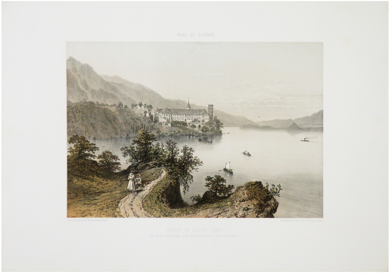
BENOIST (Félix).
[ABBAYE de HAUTECOMBE] Abbaye de Haute-Combe, sur le Lac du Bourget, près d'Aix-les-Bains. (Dép.t de la Savoie).
Nantes, Charpentier, [1864]. 257 x 327 mm.
Referenz des Buchhändlers : LBW-7184
|
|
|
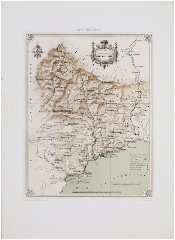
BENOIST (Félix).
[ALPES-MARITIMES] Carte du département des Alpes-Maritimes.
Nantes, Charpentier, [1863]. 350 x 262 mm.
Referenz des Buchhändlers : LBW-7594
|
|
|
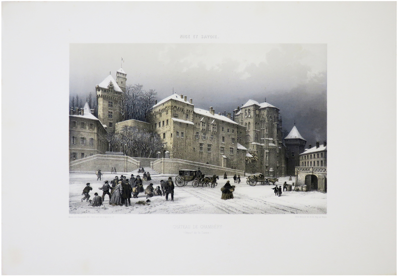
BENOIST (Félix).
[CHAMBÉRY] Château de Chambéry. (Dép.t de la Savoie).
Nantes, Charpentier, [1864]. 248 x 319 mm.
Referenz des Buchhändlers : LBW-7232
|
|
|
BENOIST (Félix).
[CHAMONIX] La Mer de Glace et la vallée de Chamonix. Vue prise du Chapeau. (Dép.t de la H.te Savoie).
Nantes, Charpentier, [1864]. 253 x 323 mm.
Referenz des Buchhändlers : LBW-7233

|
|
|
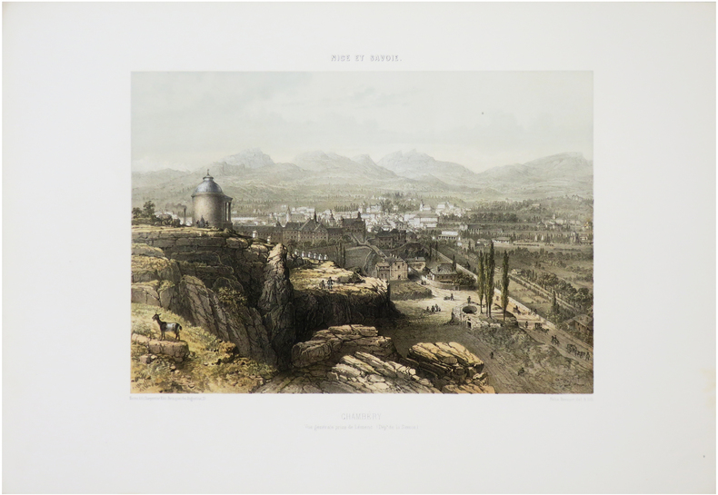
BENOIST (Félix).
[CHAMBÉRY] Chambéry. Vue générale prise de Lémenc. (Dép.t de la Savoie).
Nantes, Charpentier, [1864]. 259 x 313 mm.
Referenz des Buchhändlers : LBW-7234
|
|
|
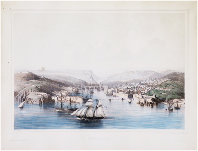
BENOIST (Philippe).
[CRIMÉE/SÉBASTOPOL] Sébastopol.
Paris, Wild, [1854]. 445 x 616 mm.
Referenz des Buchhändlers : LBW-7694
|
|
|
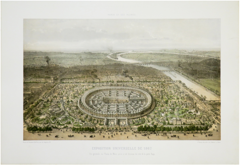
BENOIST (Philippe).
[EXPOSITION UNIVERSELLE] Paris et ses ruines. Exposition universelle de 1867. Vue générale du Champ de Mars, prise à vol d'oiseau du côté de la porte Rapp.
Nantes, Charpentier, [1872]. 287 x 403 mm.
Referenz des Buchhändlers : LBW-7281
|
|
|
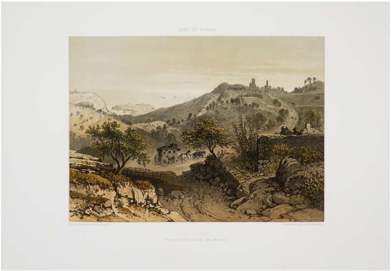
BENOIST (Félix).
[LA TURBIE & MONACO] La Turbie. Route de la Corniche et Monaco. (Alpes-Maritimes).
Nantes, Charpentier, [1863]. 260 x 316 mm.
Referenz des Buchhändlers : LBW-7536
|
|
|
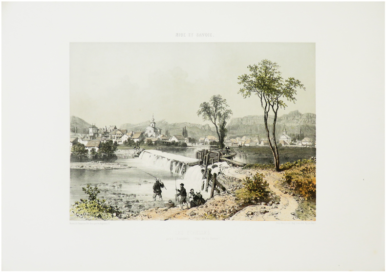
BENOIST (Félix).
[LES ÉCHELLES] Les Échelles, près Chambéry. (Dép.t de la Savoie).
Nantes, Charpentier, [1864]. 262 x 310 mm.
Referenz des Buchhändlers : LBW-7175
|
|
|
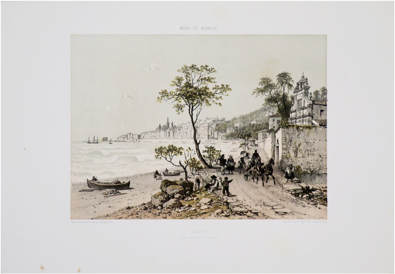
BENOIST (Félix).
[MENTON] Menton (Dép.t des Alpes maritimes).
Nantes, Charpentier, [1863]. 262 x 316 mm.
Referenz des Buchhändlers : LBW-7555
|
|
|
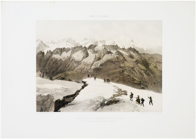
BENOIST (Félix).
[MONT-BLANC] Le Mont Blanc et la chaîne des Aiguilles Rouges. Vue prise du sommet du Buet. (Dép.t de la H.te Savoie).
Nantes, Charpentier, [1864]. 263 x 312 mm.
Referenz des Buchhändlers : LBW-7182
|
|
|
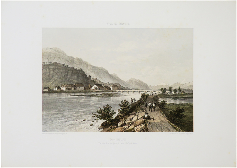
BENOIST (Félix).
[MONTMÉLIAN] Montmélian. Vue prise de la rive gauche de l'Isère. (Dép.t de la Savoie).
Nantes, Charpentier, [1864]. 249 x 312 mm.
Referenz des Buchhändlers : LBW-7231
|
|
|
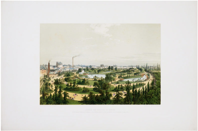
BENOIST (Félix).
[NANTES] Jardin des Plantes de Nantes nouvellement agrandi et embelli. Vue générale prise du côté de l'entrée, sur le boulevard de Sébastopol.
[1860]. 252 x 340 mm.
Referenz des Buchhändlers : LBW-6518
|
|
|
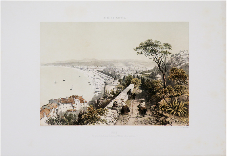
BENOIST (Félix).
[NICE] Nice. Vue prise de l'extrémité du Mont Boron (Dép.t des Alpes maritimes).
Nantes, Charpentier, [1863]. 270 x 321 mm.
Referenz des Buchhändlers : LBW-7568

|
|
|
BENOIST (Félix).
[NICE] Nice. Vue prise de la hauteur de l'ancien château. (Alpes maritimes).
Nantes, Charpentier, [1863]. 260 x 320 mm.
Referenz des Buchhändlers : LBW-7587
|
|
|
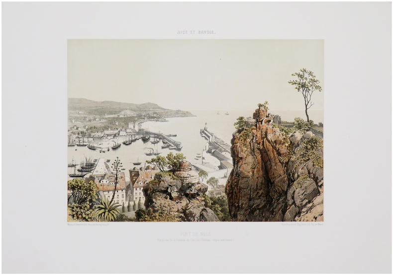
BENOIST (Félix).
[NICE] Port de Nice. Vue prise de la hauteur de l'ancien château. (Alpes maritimes).
Nantes, Charpentier, [1863]. 260 x 316 mm.
Referenz des Buchhändlers : LBW-7591
|
|
|
BENOIST (Félix).
[NICE] Nice. Vue prise de la Villa Venanson (Dép.t des Alpes maritimes).
Nantes, Charpentier, [1863]. 255 x 313 mm.
Referenz des Buchhändlers : LBW-7592

|
|
|
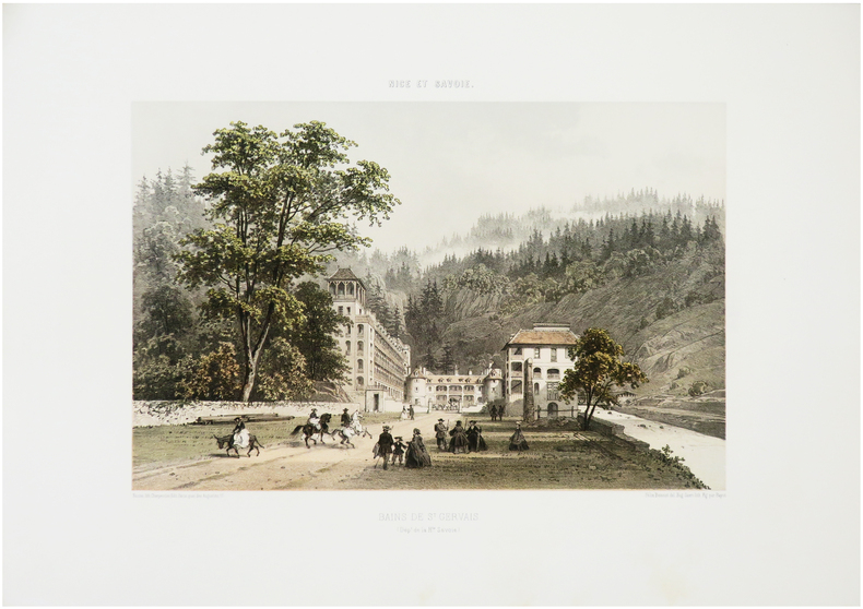
BENOIST (Félix).
[SAINT-GERVAIS-les-BAINS] Bains de S.t Gervais. (Dép.t de la H.te Savoie).
Nantes, Charpentier, [1864]. 255 x 333 mm.
Referenz des Buchhändlers : LBW-7190
|
|
|
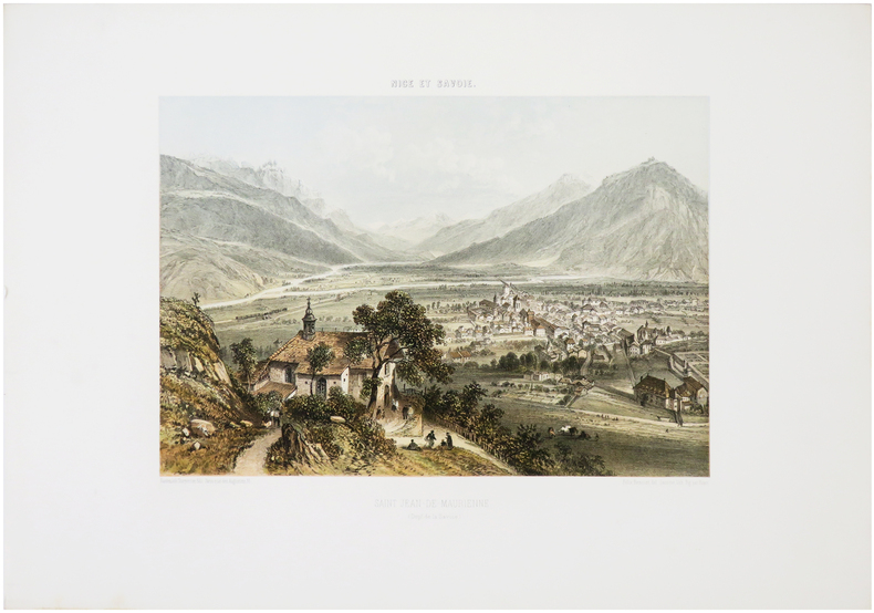
BENOIST (Félix).
[SAINT-JEAN-de-MAURIENNE] Saint Jean-de-Maurienne. (Dép.t de la Savoie).
Nantes, Charpentier, [1864]. 247 x 307 mm.
Referenz des Buchhändlers : LBW-7230
|
|
|
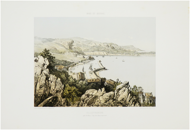
BENOIST (Félix).
[VILLEFRANCHE-sur-MER] Villefranche près de Nice. (Dép.t des Alpes-Maritimes).
Nantes, Charpentier, [1863]. 270 x 315 mm.
Referenz des Buchhändlers : LBW-7543
|
|
|
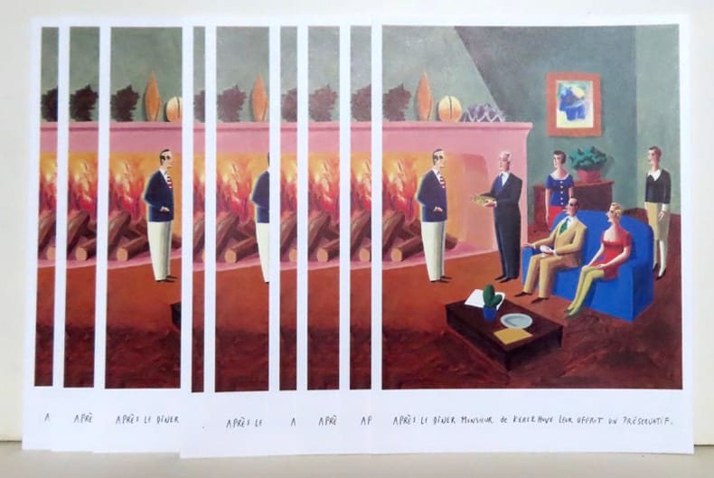
Benoît Van Innis:
Après le dîner Monsieur de Kerckhuve leur offrit un préservatif.
Carouge, Fondation du présent et les auteurs, 1991. 10 x la même grande carte postale (16x22), représentant une illustration extraite de l'album "Les aventures du latex, la bande dessinée européenne s'empare du préservatif".
Referenz des Buchhändlers : 19832
|
|
|
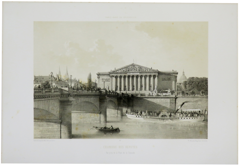
BENOIST (Philippe).
Chambre des Députés. Vue prise de la Place de la Concorde.
Paris, Henri Charpentier, [1861]. 279 x 357 mm.
Referenz des Buchhändlers : LBW-5515
|
|
|
BENJOWSKY Moritz August von; FORSTER Georg (trad.):
Des Grafen Moritz August von Benjowsky Begebenheiten und Reisen. Zweiter Band. Fahrt durch das Stille Meer über Japan und Formosa nach China; und Errichtung einer fransosischen Colonie zu Madagascar.
Leipzig, Dykische Buchhandlung, 1791. Petit in-8 de [6]-602 pages, cartonnage gris, étiquette manuscrite au dos, en grande partie effacée, tranches mouchetées. Premier et dernier cahier déboîtés mais parfaitement solidaires. Quelques rousseurs.
Referenz des Buchhändlers : 10281
|
|
|
Benn André:
Ex-libris.
Genève, Librairie Jérémiah. Ex-libris au format 13 x 19 cm., à l'état de neuf.
Referenz des Buchhändlers : 5415

|
|
|
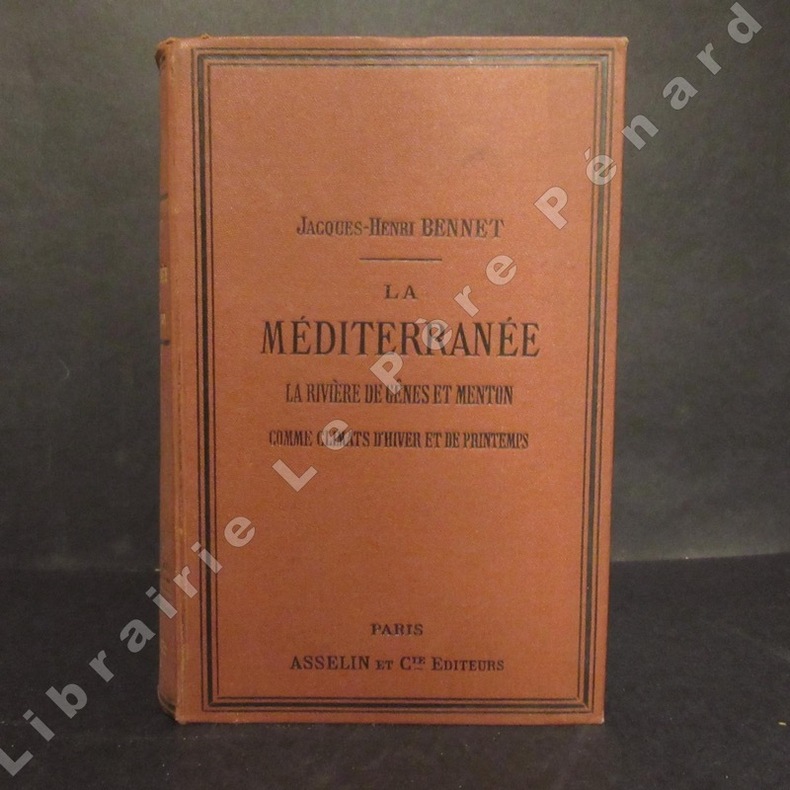
BENNET, Jacques-Henri
La Méditerranée. La rivière de Gênes et Menton comme climats d'hiver et de printemps.
1880 A Paris, Chez Asselin et Cie, Libraires de la Faculté de médecine - 1880 - Fort in-12 (12x18cm environ), pleine percaline rouge, encadrements des plats à froid, titre doré au dos avec décor à froid - Gardes bleues, tranches mouchetées - 432 p. - Avec des gravures in et hors texte, certaines dépliantes - Belles cartes en couleurs dépliantes en début d'ouvrage
Referenz des Buchhändlers : 109633
|
|
|
Benjamin HANNUNA
Le GUIDE MARABOUT du POKER
Un ouvrage de 192 pages, format 115 x 180 mm, illustré, broché couverture couleurs, publié en 1979, Marabout
Referenz des Buchhändlers : LFA-126720427
|
|
|
BENOIST (Philippe).
Les Invalides. Façade principale du côté de l'esplanade.
Paris, Henri Charpentier, [1861]. 290 x 363 mm.
Referenz des Buchhändlers : LBW-5513

|
|
|
Bensard Eva Fransoua
Ma petite histoire de la Bretagne
PLACE VICTOIRES 2017 64 pages 24 8x26 4x1 4cm. 2017. Relié. 64 pages.
Referenz des Buchhändlers : 500137438

|
|
|
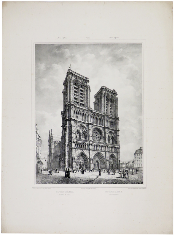
BENOIST (Philippe) & JACOTTET (Louis-Julien).
Notre-Dame. Cathédrale de Paris - Notre-Dame. Paris' Cathedral.
[circa 1840]. 390 x 280 mm.
Referenz des Buchhändlers : LBW-5673
|
|
|
BENOIST (Philippe).
Palais de l'Industrie. Entrée principale.
Paris, Henri Charpentier, [1861]. 278 x 358 mm.
Referenz des Buchhändlers : LBW-5511

|
|
|
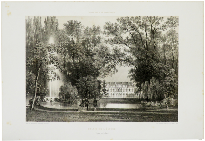
BENOIST (Félix).
Palais de l'Élysée. (Façade sur le parc).
Paris, Henri Charpentier, [1861]. 294 x 366 mm.
Referenz des Buchhändlers : LBW-5512
|
|
|
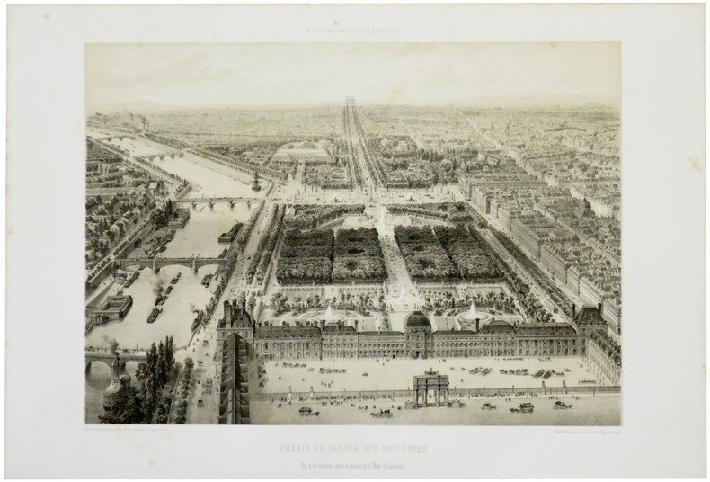
BENOIST (Félix).
Palais et Jardin des Tuileries. Vue à vol d'oiseau, prise au dessus de la Place du Carrousel.
Paris, Henri Charpentier, [1861]. 307 x 373 mm.
Referenz des Buchhändlers : LBW-5516
|
|
|
BENOIST (Philippe).
Palais de l'Industrie aux Champs Élysées à Paris.
Paris & Londres, Goupil & C.e & E. Gambart, 1er mai 1855. 390 x 970 mm.
Referenz des Buchhändlers : LBW-8153

|
|
|
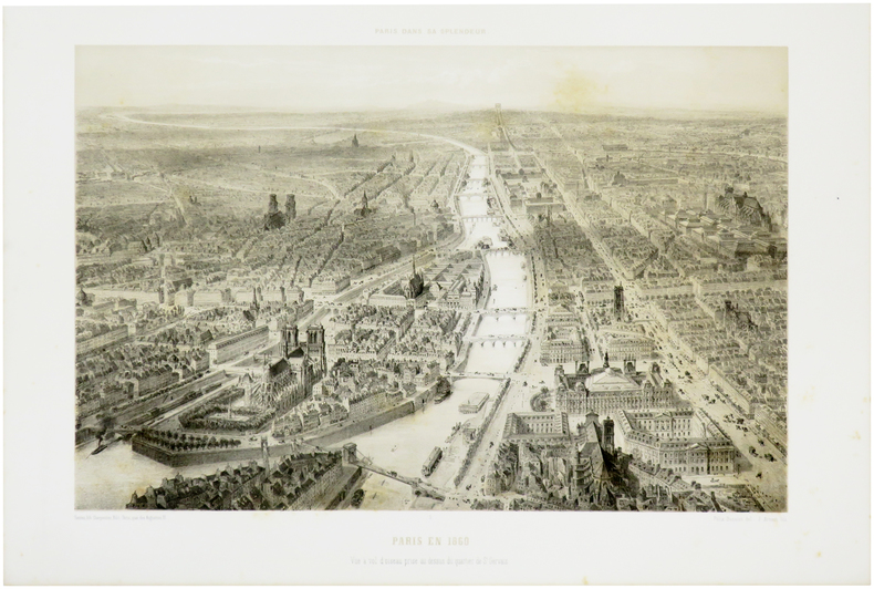
BENOIST (Félix).
Paris en 1860. Vue à vol d'oiseau prise au dessus du quartier de S.t Gervais.
Paris, Henri Charpentier, [1861]. 303 x 399 mm.
Referenz des Buchhändlers : LBW-5508
|
|
|
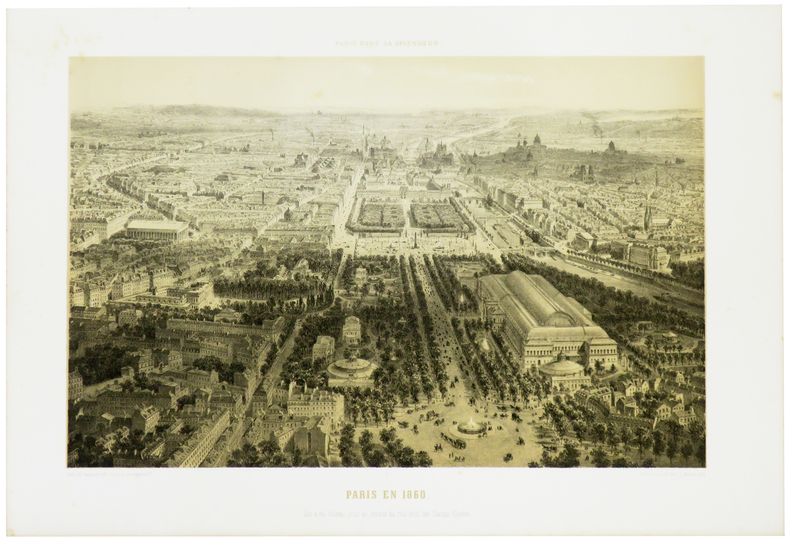
BENOIST (Félix).
Paris en 1860. Vue à vol d'oiseau, prise au dessus du rond-point des Champs-Élysées.
Paris, Henri Charpentier, [1861]. 293 x 400 mm.
Referenz des Buchhändlers : LBW-5509
|
|
|
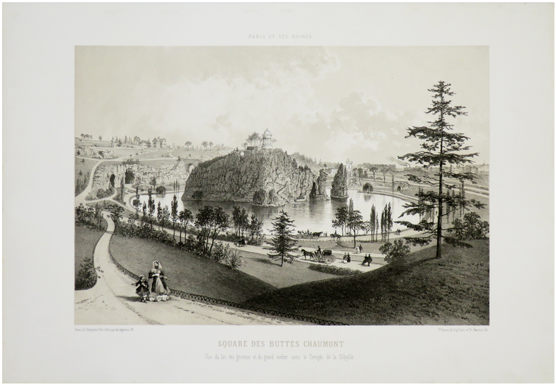
BENOIST (Félix).
Paris et ses ruines. Square des Buttes Chaumont. Vue du lac, des grottes et du grand rocher avec le Temple de Sibylle.
Nantes, Charpentier, [1872]. 287 x 365 mm.
Referenz des Buchhändlers : LBW-7280
|
|
|
Ben Younes, Alia and Habib
All Tunisia : Collection All Africa
Very faint marking to title page. No other marks or inscriptions. Creasing and minor rubbing to covers. Very clean very tight pages. 128pp. History and tourist guide to Tunisia, very well illustrated.

|
|
|
BENARD Robert (Parigi 1734-1777)
Carte Reduite du Globe Terrestre
Mappa del mondo, basata sulla proiezione di Mercator, disegnata da Seguin e pubblicata da Robert Benard.Incisa da J. B. L. Aubert, la mappa fa parte dei Voyages autour du Monde et vers les deux Poles par Terre et par Mer, di Pierre Marie François de Pages, stampato nel 1782.Nato da una famiglia nobile, l'ufficiale di marina francese Pierre Marie François de Pages fece un viaggio di cinque anni in tutto il mondo, tra il 1767 e il 1771. Successivamente partecipò a un viaggio di due anni al Polo Sud, tra il 1773 e il 1774. Alla fine ho fatto un viaggio al Polo Nord nel 1776. Questi viaggi sono stati raccontati nella sua pubblicazione del 1782.Incisione in rame, solite pieghe di carta, altrimenti in buone condizioni. Map of the World on Mercator's projection by Seguit and Robert Benard.Engraved by J. B. L. Aubert the map is part of the Voyages autour du Monde et vers les deux Poles par Terre et par Mer, by Pierre Marie François de Pages, printed in 1782.Born of noble family, a French naval officer, Pierre Marie François de Pages, made a five-year voyage around the world, between 1767 and 1771. Subsequently he took part in a two year voyage to the South Pole, between 1773 and 1774. Finally he made a trip to the North Pole in 1776. These voyages were recounted in his publication of 1782. Engraving, usual folds, otherwise in good condition.

|
|
|
Benchmark Maps & Atlases
Alaska Benchmark Road & Recreation 2016 Atlas
Benchmark Maps 2016. Paperback. New. 2016 edition. 144 pages. 15.50x10.80x0.50 inches. Benchmark Maps paperback
Referenz des Buchhändlers : __0929591143 ISBN : 0929591143 9780929591148

|
|
|
Benchmark Maps
Albuquerque Street Atlas
Benchmark Maps 2000. Paperback. Good. Disclaimer:A copy that has been read but remains in clean condition. All pages are intact and the cover is intact. The spine may show signs of wear. Pages can include limited notes and highlighting and the copy can include previous owner inscriptions. At ThriftBooks our motto is: Read More Spend Less.Dust jacket quality is not guaranteed. Benchmark Maps paperback
Referenz des Buchhändlers : G0929591526I3N00 ISBN : 0929591526 9780929591520

|
|
|
Benchmark Maps
Arizona Benchmark Road & Recreation Atlas
2018-01-05. New. Ships with Tracking Number! INTERNATIONAL WORLDWIDE Shipping available. May be re-issue. Buy with confidence excellent customer service! unknown
Referenz des Buchhändlers : 0929591186n ISBN : 0929591186 9780929591186

|
|
 Per e-mail erhalten
 Als pdf-Dokument herunterladen
 RSS feed


