|
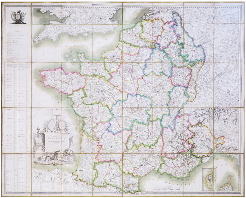
BELLEYME (Pierre de).
Carte de la France divisée en 108 départements, et subdivisée en arrondissemens communaux présentée à l'Assemblée Nationale. Corrigée en l'an VIII.
Paris, M. de Belleyme, 1791-1800 [1802]. En 40 sections montées sur toile et pliées, formant une carte de 1,31 x 1,63 m ; onglet de vélin portant le titre manuscrit ; étiquette au dos de l'éditeur parisien Goujon ; sous étui de papier marbré vert avec titre à froid sur le premier plat.
书商的参考编号 : LBW-6945
|
|
|
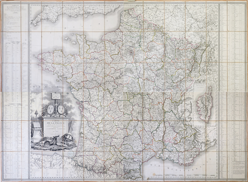
BELLEYME (Pierre de).
Carte de la France divisée en 83 départements et subdivisée en districts avec les chefs-lieux de cantons présentée à l'Assemblée Nationale et au Roi.
Paris, Vignon, 1791. En 4 feuilles non jointes, coupées en sections montées sur toile et pliées, formant une carte de 1,15 x 1,58 m ; étiquette en forme de médaillon de l'éditeur parisien Vignon, collée sous le titre, onglets de vélin numérotés.
书商的参考编号 : LBW-4323
|
|
|
BELLICAUD (Docteur).-
Nouveau traité de Bridge-Plafond. Edition nouvelle entièrement refondue et considérablement augmentée.
P., Stock, 1931, in 12 broché, 327pp. ; couverture fanée.
书商的参考编号 : 30821
|
|
|
BELLIN Jacques Nicolas Sur les Manuscrits du Depot des Cartes De la Marine
Carte Des Isles Philippines
Paris. Map. Copper engraving with hand coloring. Image measures 7.75 x 11". This map of the Philippines shows the southern half of the archipelago including the large islands of Palawan and Mindanao and the smaller islands of the Visayas. The coastlines are detailed with great care while pictorial mountains describe the volcanic topography of the region. To the left of the decorative title cartouche is a note that reads in rough translation "It is said that there are many islands of different sizes in this region of which neither the expanse the number nor the location is known." The map was published in Bellin's "Petit Atlas Maritime" which covered the coasts and important port cities of the known world. This map is in excellent condition with no chips or tears. Dark impression on bright paper. Minor offsetting in lower right corner. Jacques Nicolas Bellin 1703-1772 was the official hydrographer to the French king and the first person to hold the title of "Ing�nieur de la Marine of the Depot des cartes et plans de la Marine" chief engineer of the French Hydrographical Office. He was particularly well known for his maps of the French Empire especially the territories in North America. This map is a fine example of his detailed work. Paris unknown
书商的参考编号 : 243652

|
|
|
Bellin Jacques Nicolas Pugsley William H. William Howard WH. Pugsley Collection of Early Canadian Maps W. H.
Carte reduite du Golphe de St. Laurent : contenant l'Isle de Terre-Neuve et partie de la Coste des Esquimaux l'Isle Royale l'Isle St. Jean et celle d'Anticosti & ca. 1754 Leather Bound
2019. Leather Bound. New. Leather Binding on Spine and Corners with Golden Leaf Printing on round Spine extra customization on request like complete leather Golden Screen printing in Front Color Leather Colored book etc. Reprinted in 2019 with the help of original edition published long back 1754. This book is printed in black & white sewing binding for longer life Printed on high quality Paper re-sized as per Current standards professionally processed without changing its contents. As these are old books we processed each page manually and make them readable but in some cases some pages which are blur or missing or black spots. If it is multi volume set then it is only single volume if you wish to order a specific or all the volumes you may contact us. We expect that you will understand our compulsion in these books. We found this book important for the readers who want to know more about our old treasure so we brought it back to the shelves. Hope you will like it and give your comments and suggestions. Lang: - French. EXTRA 10 DAYS APART FROM THE NORMAL SHIPPING PERIOD WILL BE REQUIRED FOR LEATHER BOUND BOOKS. COMPLETE LEATHER WILL COST YOU EXTRA US$ 25 APART FROM THE LEATHER BOUND BOOKS. hardcover
书商的参考编号 : LB1111007010922
|
|
|
Bellin Jacques Nicolas Pugsley William H. William Howard WH. Pugsley Collection of Early Canadian Maps W. H.
Carte reduite du Golphe de St. Laurent : contenant l'Isle de Terre-Neuve et partie de la Coste des Esquimaux l'Isle Royale l'Isle St. Jean et celle d'Anticosti & ca. 1754 FULL LEATHER BOUND
2019. SUPER DELUXE EDITION. New. Antique look with Golden Leaf Printing and embossing with round Spine completely handmade bindingextra customization on request like Color Leather Colored book special gold leaf printing etc. Reprinted in 2019 with the help of original edition published long back 1754. This book is printed in black & white sewing binding for longer life Printed on high quality Paper re-sized as per Current standards professionally processed without changing its contents. As these are old books we processed each page manually and make them readable but in some cases some pages which are blur or missing or black spots. If it is multi volume set then it is only single volume if you wish to order a specific or all the volumes you may contact us. We expect that you will understand our compulsion in these books. We found this book important for the readers who want to know more about our old treasure in old look so we brought it back to the shelves. Hope you will like it and give your comments and suggestions. Lang: - French. EXTRA 10 DAYS APART FROM THE NORMAL SHIPPING PERIOD WILL BE REQUIRED. Normal Hardbound Edition is also available on request. unknown
书商的参考编号 : SD1111007010922
|
|
|
Bellin Jacques Nicolas Pugsley William H. William Howard WH. Pugsley Collection of Early Canadian Maps W. H.
Carte reduite du Golphe de St. Laurent : contenant l'Isle de Terre-Neuve et partie de la Coste des Esquimaux l'Isle Royale l'Isle St. Jean et celle d'Anticosti & ca. 1754
2019. Paperback. New. Lang: - French. Reprinted in 2019 with the help of original edition published long back 1754. This book is Printed in black & white sewing binding for longer life with Matt laminated multi-Colour Soft Cover HARDCOVER EDITION IS ALSO AVAILABLE Printed on high quality Paper re-sized as per Current standards professionally processed without changing its contents. As these are old books we processed each page manually and make them readable but in some cases some pages which are blur or missing or black spots. If it is multi volume set then it is only single volume if you wish to order a specific or all the volumes you may contact us. We expect that you will understand our compulsion in these books. We found this book important for the readers who want to know more about our old treasure so we brought it back to the shelves. Any type of Customisation is possible with extra charges. Hope you will like it and give your comments and suggestions. paperback
书商的参考编号 : PB1111007010922
|
|
|
Bellin Jacques Nicolas Pugsley William H. William Howard WH. Pugsley Collection of Early Canadian Maps W. H.
Carte reduite du Golphe de St. Laurent : contenant l'Isle de Terre-Neuve et partie de la Coste des Esquimaux l'Isle Royale l'Isle St. Jean et celle d'Anticosti & ca. 1754 Hardcover
2019. Hardcover. New. Lang: - French. Reprinted in 2019 with the help of original edition published long back 1754. This book is Printed in black & white Hardcover sewing binding for longer life with Matt laminated multi-Colour Dust Cover Printed on high quality Paper re-sized as per Current standards professionally processed without changing its contents. As these are old books we processed each page manually and make them readable but in some cases some pages which are blur or missing or black spots. If it is multi volume set then it is only single volume if you wish to order a specific or all the volumes you may contact us. We expect that you will understand our compulsion in these books. We found this book important for the readers who want to know more about our old treasure so we brought it back to the shelves. Any type of Customisation is possible with extra charges. Hope you will like it and give your comments and suggestions. hardcover
书商的参考编号 : 1111007010922
|
|
|
Bellin Jacques Nicolas France. Depot des cartes et plans de la marine France. Ministere de la marine. fmo RIBRL
Observations sur la Carte de l'isle de Saint Domingue et de ses débouquemens : dressée au Dépôt des plans de la Marine pour le service des vaisseaux du roy. Par ordre de M. Rouillé secretaire d'etat ayant le département de la Marine 1750 1750 Leather Bound
2019. Leather Bound. New. Leather Binding on Spine and Corners with Golden Leaf Printing on round Spine. Reprinted in 2019 with the help of original edition published long back 1750. This book is printed in black & white sewing binding for longer life Printed on high quality Paper re-sized as per Current standards professionally processed without changing its contents. As these are old books we processed each page manually and make them readable but in some cases some pages which are blur or missing or black spots. If it is multi volume set then it is only single volume if you wish to order a specific or all the volumes you may contact us. We expect that you will understand our compulsion in these books. We found this book important for the readers who want to know more about our old treasure so we brought it back to the shelves. Hope you will like it and give your comments and suggestions. Lang: - fre Pages 18. EXTRA 10 DAYS APART FROM THE NORMAL SHIPPING PERIOD WILL BE REQUIRED FOR LEATHER BOUND BOOKS. FOLIO EDITION IS ALSO AVAILABLE. hardcover
书商的参考编号 : LB1111008296610
|
|
|
Bellin Jacques Nicolas Pugsley William H. William Howard donor WH. Pugsley Collection of Early Canadian Maps Homann Erb
Partie occidentale de la Nouvelle France ou du Canada 1755 Leather Bound
2019. Leather Bound. New. Leather Binding on Spine and Corners with Golden Leaf Printing on round Spine extra customization on request like complete leather Golden Screen printing in Front Color Leather Colored book etc. Reprinted in 2019 with the help of original edition published long back 1755. This book is printed in black & white sewing binding for longer life Printed on high quality Paper re-sized as per Current standards professionally processed without changing its contents. As these are old books we processed each page manually and make them readable but in some cases some pages which are blur or missing or black spots. If it is multi volume set then it is only single volume if you wish to order a specific or all the volumes you may contact us. We expect that you will understand our compulsion in these books. We found this book important for the readers who want to know more about our old treasure so we brought it back to the shelves. Hope you will like it and give your comments and suggestions. Lang: - French. EXTRA 10 DAYS APART FROM THE NORMAL SHIPPING PERIOD WILL BE REQUIRED FOR LEATHER BOUND BOOKS. COMPLETE LEATHER WILL COST YOU EXTRA US$ 25 APART FROM THE LEATHER BOUND BOOKS. hardcover
书商的参考编号 : LB1111007010936
|
|
|
Bellin Jacques Nicolas Pugsley William H. William Howard donor WH. Pugsley Collection of Early Canadian Maps Homann Erb
Partie occidentale de la Nouvelle France ou du Canada 1755 FULL LEATHER BOUND
2019. SUPER DELUXE EDITION. New. Antique look with Golden Leaf Printing and embossing with round Spine completely handmade bindingextra customization on request like Color Leather Colored book special gold leaf printing etc. Reprinted in 2019 with the help of original edition published long back 1755. This book is printed in black & white sewing binding for longer life Printed on high quality Paper re-sized as per Current standards professionally processed without changing its contents. As these are old books we processed each page manually and make them readable but in some cases some pages which are blur or missing or black spots. If it is multi volume set then it is only single volume if you wish to order a specific or all the volumes you may contact us. We expect that you will understand our compulsion in these books. We found this book important for the readers who want to know more about our old treasure in old look so we brought it back to the shelves. Hope you will like it and give your comments and suggestions. Lang: - French. EXTRA 10 DAYS APART FROM THE NORMAL SHIPPING PERIOD WILL BE REQUIRED. Normal Hardbound Edition is also available on request. unknown
书商的参考编号 : SD1111007010936
|
|
|
Bellin Jacques Nicolas Pugsley William H. William Howard donor WH. Pugsley Collection of Early Canadian Maps Homann Erb
Partie occidentale de la Nouvelle France ou du Canada 1755
2019. Paperback. New. Lang: - French. Reprinted in 2019 with the help of original edition published long back 1755. This book is Printed in black & white sewing binding for longer life with Matt laminated multi-Colour Soft Cover HARDCOVER EDITION IS ALSO AVAILABLE Printed on high quality Paper re-sized as per Current standards professionally processed without changing its contents. As these are old books we processed each page manually and make them readable but in some cases some pages which are blur or missing or black spots. If it is multi volume set then it is only single volume if you wish to order a specific or all the volumes you may contact us. We expect that you will understand our compulsion in these books. We found this book important for the readers who want to know more about our old treasure so we brought it back to the shelves. Any type of Customisation is possible with extra charges. Hope you will like it and give your comments and suggestions. paperback
书商的参考编号 : PB1111007010936
|
|
|
Bellin Jacques Nicolas Pugsley William H. William Howard donor WH. Pugsley Collection of Early Canadian Maps Homann Erb
Partie occidentale de la Nouvelle France ou du Canada 1755 Hardcover
2019. Hardcover. New. Lang: - French. Reprinted in 2019 with the help of original edition published long back 1755. This book is Printed in black & white Hardcover sewing binding for longer life with Matt laminated multi-Colour Dust Cover Printed on high quality Paper re-sized as per Current standards professionally processed without changing its contents. As these are old books we processed each page manually and make them readable but in some cases some pages which are blur or missing or black spots. If it is multi volume set then it is only single volume if you wish to order a specific or all the volumes you may contact us. We expect that you will understand our compulsion in these books. We found this book important for the readers who want to know more about our old treasure so we brought it back to the shelves. Any type of Customisation is possible with extra charges. Hope you will like it and give your comments and suggestions. hardcover
书商的参考编号 : 1111007010936
|
|
|
BELLIN (Jacques Nicolas).
PLAN DE ROUEN ET DES ENVIRONS.
S. l., Croisey (graveur), sd. (1764). Plan gravé de 23,5 x 34,5 cm (cuvette), avec de belles marges et rehauts de couleurs.
书商的参考编号 : 9372
|
|
|
BELLIN (Jacques Nicolas).
PLAN DE ROUEN ET DES ENVIRONS.
S. l., Croisey (graveur), sd. (1764). Plan gravé de 23,5 x 34,5 cm (cuvette), avec marges.
书商的参考编号 : 9375
|
|
|
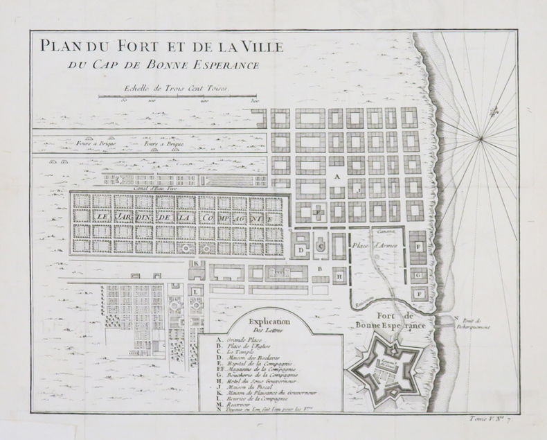
BELLIN (Jacques-Nicolas).
[AFRIQUE du SUD/LE CAP] Plan du fort et de la ville du Cap de Bonne Espérance.
[circa 1760]. 209 x 265 mm.
书商的参考编号 : LBW-4532
|
|
|
BELLIN (Jacques-Nicolas).
[AFRIQUE DU SUD] Carte de la baye de Saldana ou Saldane.
[circa 1760]. 200 x 278 mm.
书商的参考编号 : LBW024b7
|
|
|
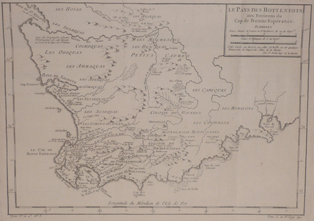
BELLIN (Jacques-Nicolas).
[AFRIQUE DU SUD] Le pays des Hottentots aux environs du Cap de Bonne Espérance.
[circa 1760]. 245 x 348 mm.
书商的参考编号 : LBW024b8
|
|
|
BELLIN (Jacques-Nicolas).
[ALGERIE] Plan de la ville forts et port d'Alger.
[1764]. 211 x 169 mm.
书商的参考编号 : LBW01b58
|
|
|
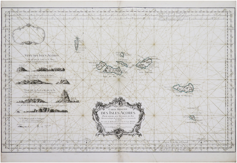
BELLIN (Jacques-Nicolas).
[AÇORES] Carte réduite des Isles Açores.
Paris, M. Bellin, 1755. 557 x 897 mm.
书商的参考编号 : LBW-8147
|
|
|
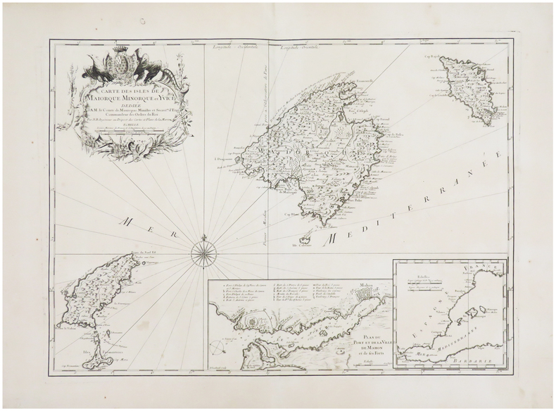
BELLIN (Jacques-Nicolas).
[BALÉARES/MINORQUE] Carte des isles de Maiorque Minorque et Yvice.
Paris, 1740. 408 x 563 mm.
书商的参考编号 : LBW-6526
|
|
|
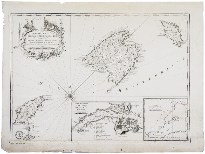
BELLIN (Jacques-Nicolas).
[BALÉARES] Carte des isles de Maiorque Minorque et Yvice.
[Paris], 1740-1756. 410 x 576 mm.
书商的参考编号 : LBW-5915
|
|
|
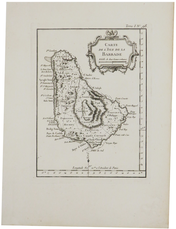
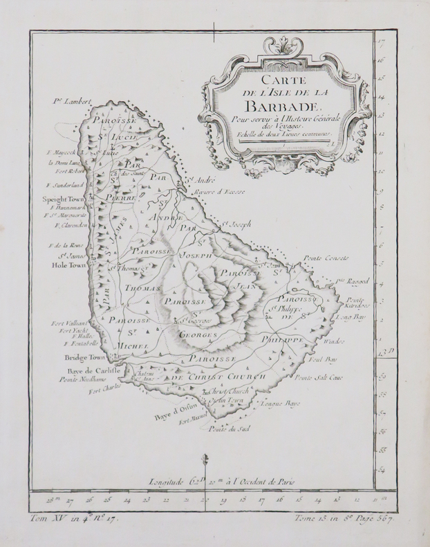
BELLIN (Jacques-Nicolas).
[BARBADE] Carte de l'isle de la Barbade.
1764. 200 x 147 mm.
书商的参考编号 : LBW-2370
|
|
|
BELLIN (Jacques-Nicolas).
[BARBADE] Carte de l'isle de la Barbade.
[circa 1770]. 199 x 149 mm.
书商的参考编号 : LBW-4879
|
|
|
BELLIN (Jacques-Nicolas).
[BELLE-ÎLE-en-MER] Carte de l'isle de Belle Isle.
[Paris], 1764. 215 x 355 mm.
书商的参考编号 : LBW-8294

|
|
|
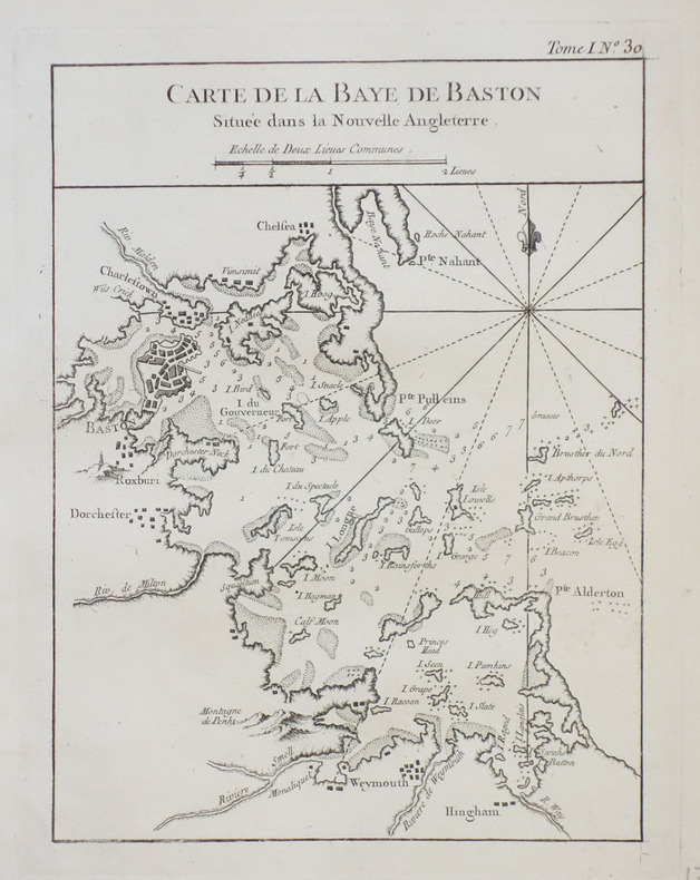
BELLIN (Jacques-Nicolas).
[BOSTON] Carte de la baye de Baston située dans la Nouvelle Angleterre.
1764. 211 x 161 mm.
书商的参考编号 : LBW-2386
|
|
|
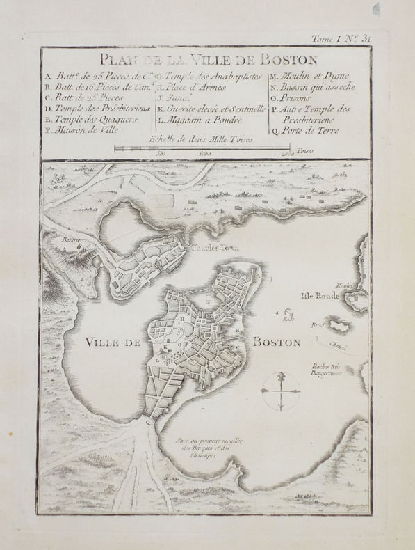
BELLIN (Jacques-Nicolas).
[BOSTON] Plan de la ville de Boston et ses environs.
1764. 212 x 152 mm.
书商的参考编号 : LBW-2398
|
|
|
BELLIN (Jacques-Nicolas).
[BRESIL] Plan de la ville de St. Salvador capitale du Brésil.
[circa 1760]. 191 x 300 mm.
书商的参考编号 : LBW-2341

|
|
|
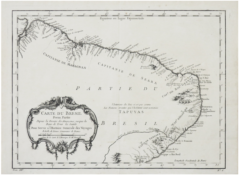
BELLIN (Jacques-Nicolas).
[BRÉSIL] Carte du Brésil, prem. partie. Depuis la rivière des Amazones jusqu'à la Baye de Tous les Saints.
[circa 1750]. 238 x 323 mm.
书商的参考编号 : LBW-6382
|
|
|
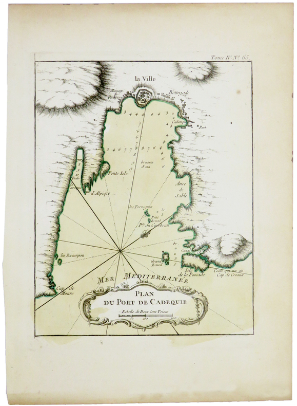
BELLIN (Jacques-Nicolas).
[CADAQUÉS] Plan du port de Cadequie.
[1764]. 220 x 175 mm.
书商的参考编号 : LBW-5420
|
|
|
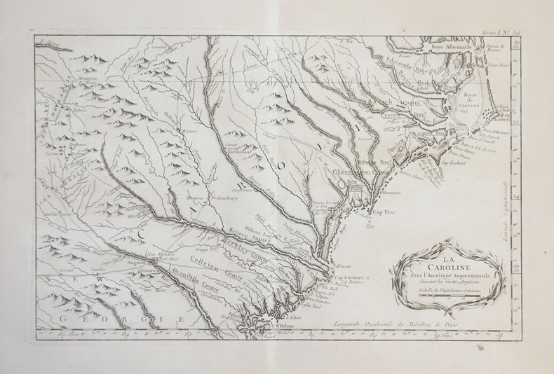
BELLIN (Jacques-Nicolas).
[CAROLINE du NORD et du SUD] La Caroline dans l'Amérique septentrionale suivant les cartes angloises.
1764. 224 x 355 mm.
书商的参考编号 : LBW-2394
|
|
|
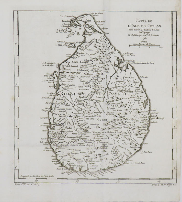
BELLIN (Jacques-Nicolas).
[CEYLAN/SRI LANKA] Carte de l'isle de Ceylan.
1750. 258 x 246 mm.
书商的参考编号 : LBW-4786
|
|
|
BELLIN (Jacques-Nicolas).
[CORSE] Carte de l'isle de Corse.
1768. 591 x 872 mm.
书商的参考编号 : LBW-4950

|
|
|
BELLIN (Jacques-Nicolas).
[CORSE] Carte de la province d'Ajaccio et fief d'Istria en quatre feuilles.
[1769]. En quatre feuilles d'environ 230-240 x 275-300 mm.
书商的参考编号 : LBW002d4

|
|
|
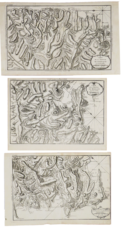
BELLIN (Jacques-Nicolas).
[CORSE] Carte de la province de Bonifacio en trois feuilles.
[1769]. En trois feuilles de 235 x 340-380 mm.
书商的参考编号 : LBW002de
|
|
|
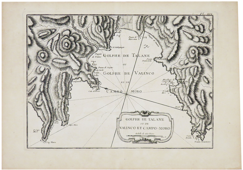
BELLIN (Jacques-Nicolas).
[CORSE] Golphe de Talane ou de Valinco et Campo-Moro.
[1769]. 210 x 288 mm.
书商的参考编号 : LBW002d5
|
|
|
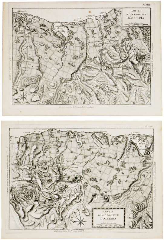
BELLIN (Jacques-Nicolas).
[CORSE] Partie de la province d'Alleria.
[1769]. En deux feuilles d'environ 225 x 325 mm.
书商的参考编号 : LBW002dd
|
|
|
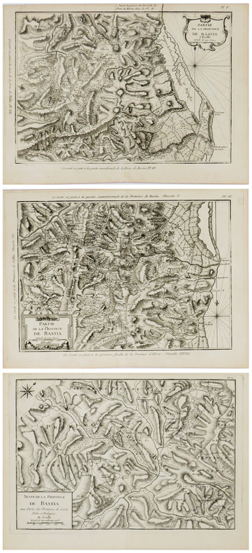
BELLIN (Jacques-Nicolas).
[CORSE] Partie de la province de Bastia. En trois feuilles.
[1769]. En trois feuilles d'environ 220 x 320 mm.
书商的参考编号 : LBW002cf
|
|
|
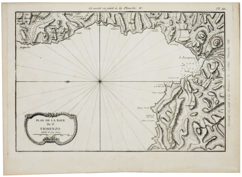
BELLIN (Jacques-Nicolas).
[CORSE] Plan de la baye de St. Fiorenzo.
[1769]. 216 x 322 mm.
书商的参考编号 : LBW002cd
|
|
|
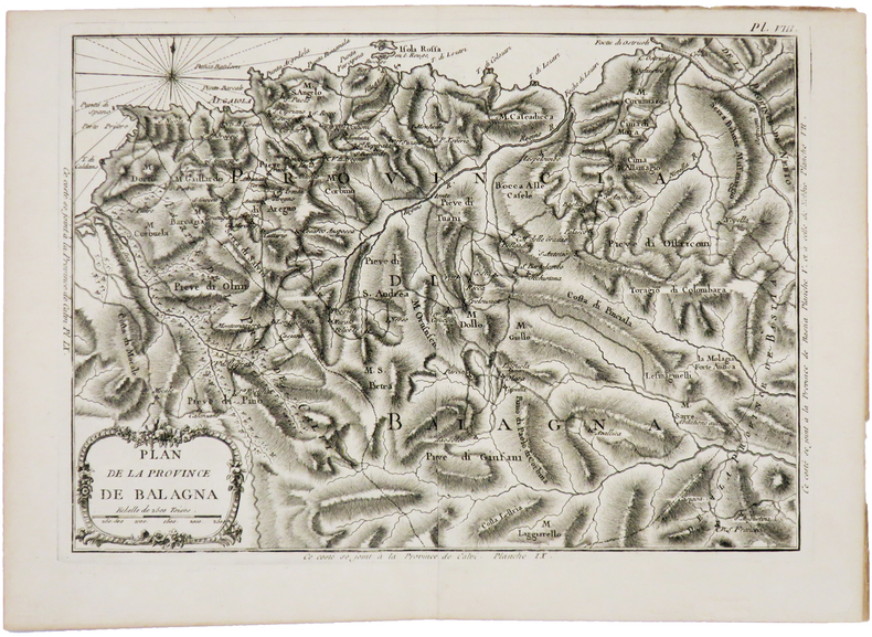
BELLIN (Jacques-Nicolas).
[CORSE] Plan de la province de Balagna.
[1769]. 222 x 310 mm.
书商的参考编号 : LBW002d1
|
|
|
BELLIN (Jacques-Nicolas).
[CORSE] Plan de la ville de Corté dans l'isle de Corse.
[1769]. 218 x 177 mm.
书商的参考编号 : LBW002e1

|
|
|
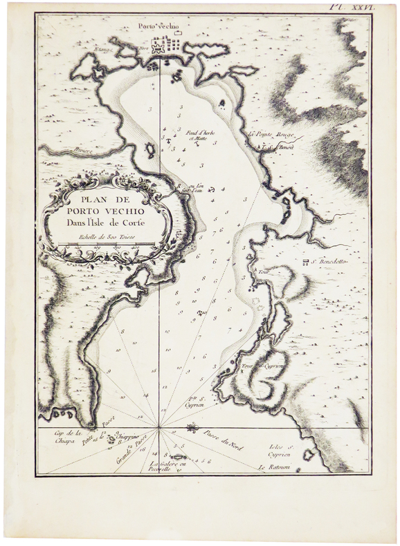
BELLIN (Jacques-Nicolas).
[CORSE] Plan de Porto Vechio dans l'isle de Corse.
[1769]. 229 x 167 mm.
书商的参考编号 : LBW002db
|
|
|
BELLIN (Jacques-Nicolas).
[CORSE] Plan des bouches de Bonifacio et partie de la coste, depuis Porto Vecchio jusqu'à Bonifacio.
[1769]. 210 x 288 mm.
书商的参考编号 : LBW002dc

|
|
|
BELLIN (Jacques-Nicolas).
[CORSE] Plan du golfe de Ventilegne et partie de la coste jusqu'à Bonifacio.
[1769]. 222 x 310 mm.
书商的参考编号 : LBW002d9

|
|
|
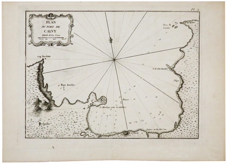
BELLIN (Jacques-Nicolas).
[CORSE] Plan du port de Calvy.
[1769]. 212 x 286 mm.
书商的参考编号 : LBW002d2
|
|
|
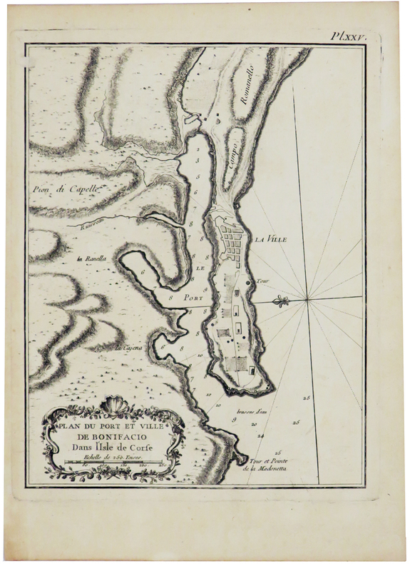
BELLIN (Jacques-Nicolas).
[CORSE] Plan du port et ville de Bonifacio dans l'isle de Corse.
[1769]. 212 x 163 mm.
书商的参考编号 : LBW002da
|
|
|
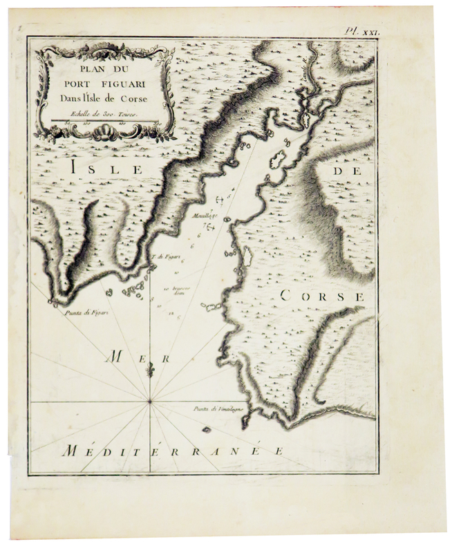
BELLIN (Jacques-Nicolas).
[CORSE] Plan du port Figuari dans l'isle de Corse.
[1769]. 218 x 177 mm.
书商的参考编号 : LBW002d7
|
|
|
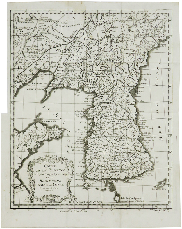
BELLIN (Jacques-Nicolas).
[CORÉE] Carte de la province de Quan-Tong ou Lyau-Tong et du royaume de Kau-Li ou Corée.
[circa 1760]. 267 x 213 mm.
书商的参考编号 : LBW-6854
|
|
|
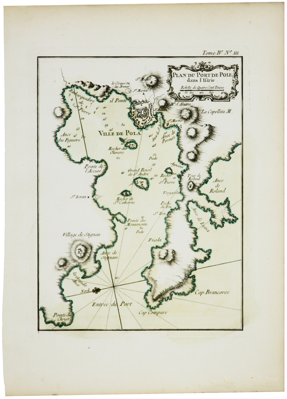
BELLIN (Jacques-Nicolas).
[CROATIE/ISTRIE] Plan du port de Pole dans l'Istrie.
[1764]. 224 x 168 mm.
书商的参考编号 : LBW-5878
|
|
|
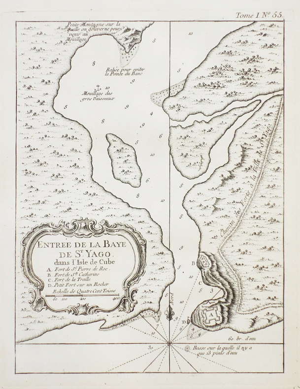
BELLIN (Jacques-Nicolas).
[CUBA] Entrée de la baye de St. Yago dans l'isle de Cube.
[1764]. 217 x 168 mm.
书商的参考编号 : LBW-2374
|
|
 ?????????
 ?????PDF???
 RSS feed


